Allsnow
-
Posts
26,462 -
Joined
-
Last visited
Content Type
Profiles
Blogs
Forums
American Weather
Media Demo
Store
Gallery
Everything posted by Allsnow
-
Nice look with higher hgts nosing down into Greenland

-
It’s happens with the American guidance inside 100 hours with S/W energy. It becomes progressive and weak because it’s focusing on the next vort coming
- 373 replies
-
- 3
-

-
- heavy rain
- wind event
- (and 2 more)
-
Lots of model chaos going on with this storm. The American guidance is now showing its progressive bias.
-
GFS progressive bias on show now with getting the first system out of the way and trying to make the second one a thing. Don’t fall for it
- 373 replies
-
- 1
-
-
- heavy rain
- wind event
- (and 2 more)
-

December 2020 General Discussions & Observations Thread
Allsnow replied to bluewave's topic in New York City Metro
That’s a legit cold shot coming with the wave 1 strat hit. We should have shots at snow between the 10th-20th. Looks like overrunning stuff and clippers -
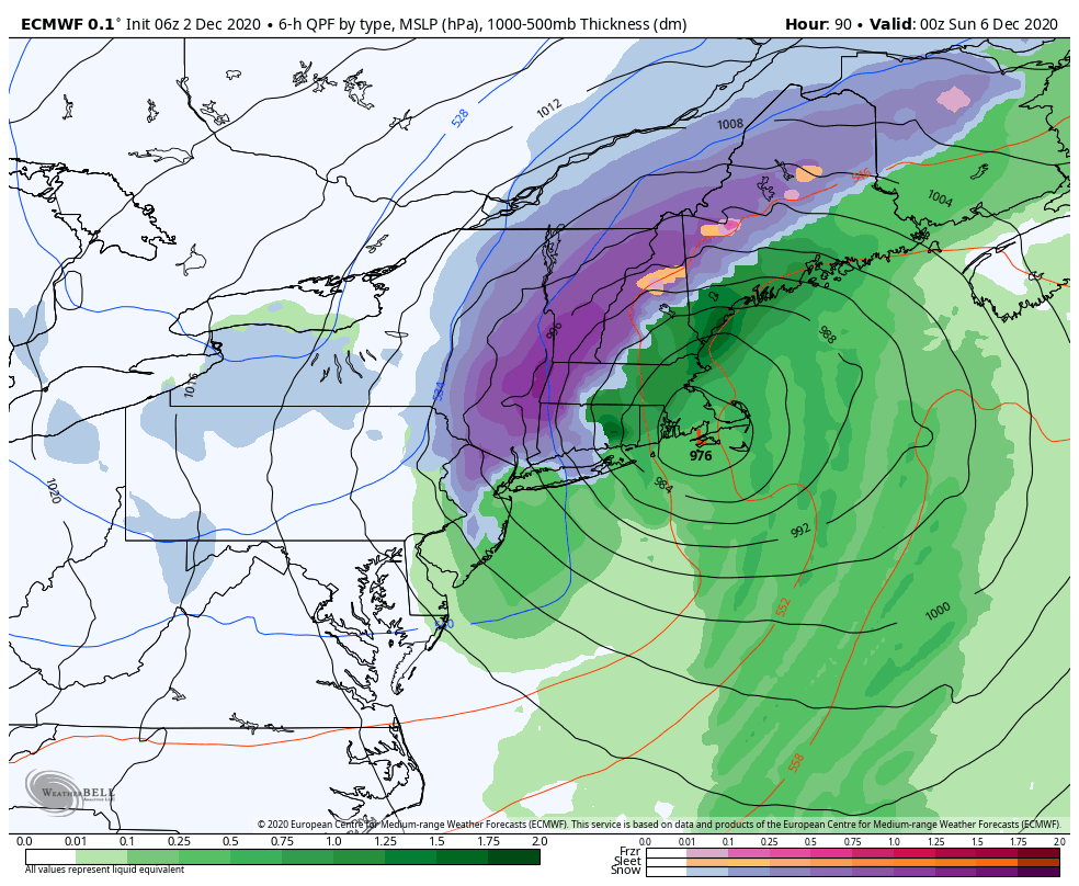
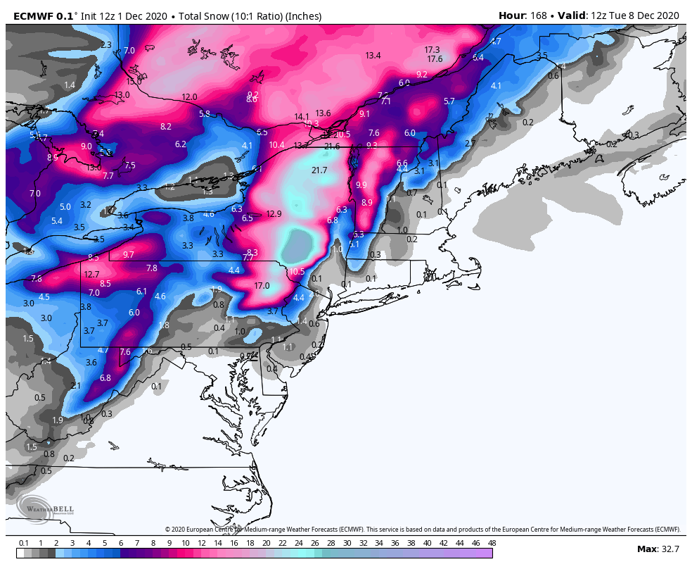
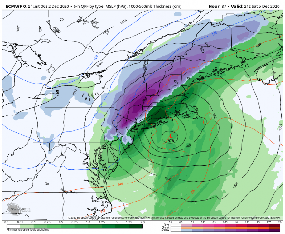
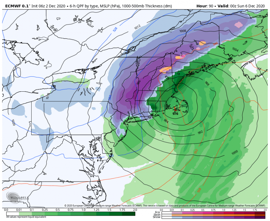
06z euro crushes NW Jersey and gets flakes down to LI This is a perfect track for snow all the way to the coast but the airmass is putrid. Look like we will crack the cutter/hugger tracks with this one @bluewave
- 373 replies
-
- 5
-
-

-
- heavy rain
- wind event
- (and 2 more)
-
December 2020 General Discussions & Observations Thread
Allsnow replied to bluewave's topic in New York City Metro
We are not going to sustain a ridge out there for weeks on end. Need to make the most of our opportunities when we have it. A ridge kissing the west coast up into the artic works also. Which is what the ensembles have. -
December 2020 General Discussions & Observations Thread
Allsnow replied to bluewave's topic in New York City Metro
Initially it will dump there as the ridge rolls forward and pac reshuffles. Show those maps pass that hour lol -
December 2020 General Discussions & Observations Thread
Allsnow replied to bluewave's topic in New York City Metro
-
December 2020 General Discussions & Observations Thread
Allsnow replied to bluewave's topic in New York City Metro
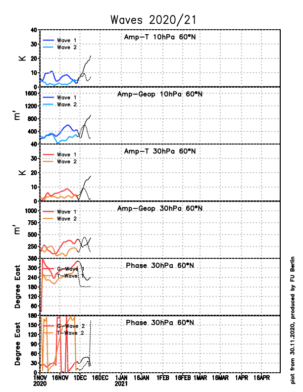
I’m talking about the wave 1 hit on the strat. It’s throwing a punch at the SPV and getting it off the pole. This will open the artic flood gates at a piece of the TPV goes into Hudson Bay -
December 2020 General Discussions & Observations Thread
Allsnow replied to bluewave's topic in New York City Metro
-
December 2020 General Discussions & Observations Thread
Allsnow replied to bluewave's topic in New York City Metro
-
December 2020 General Discussions & Observations Thread
Allsnow replied to bluewave's topic in New York City Metro
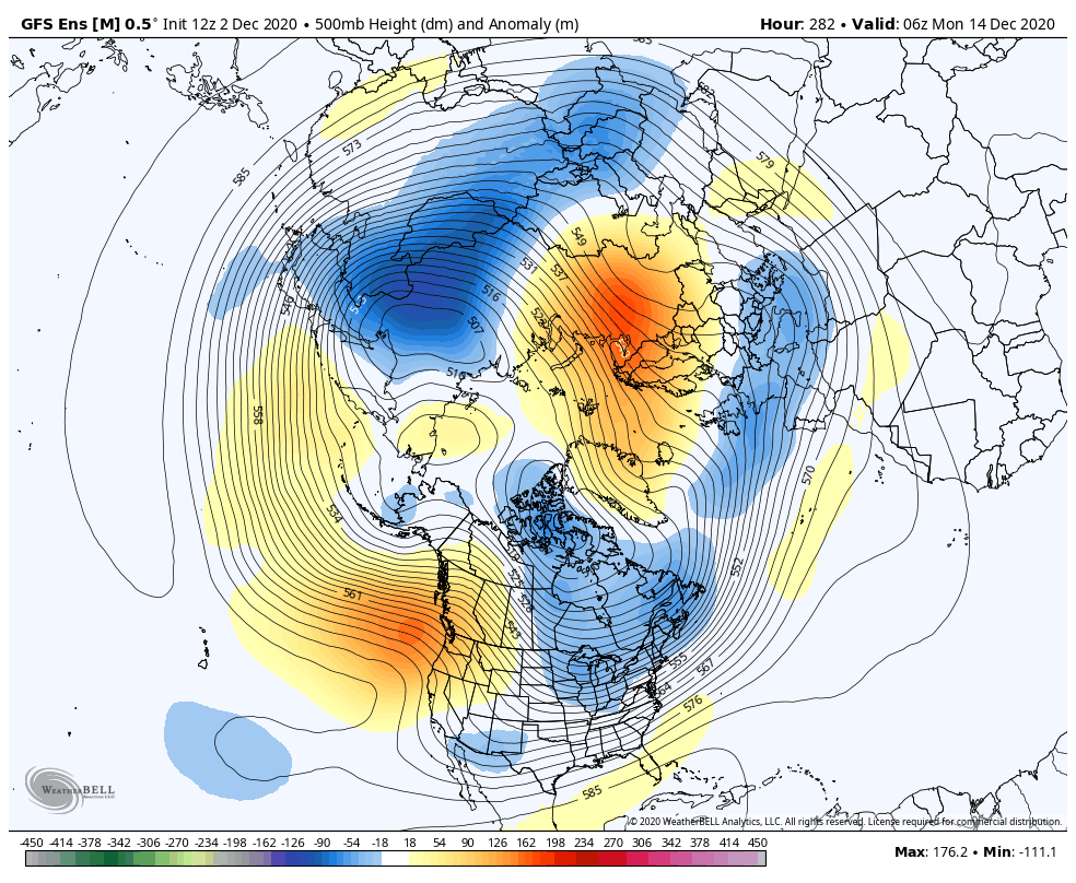
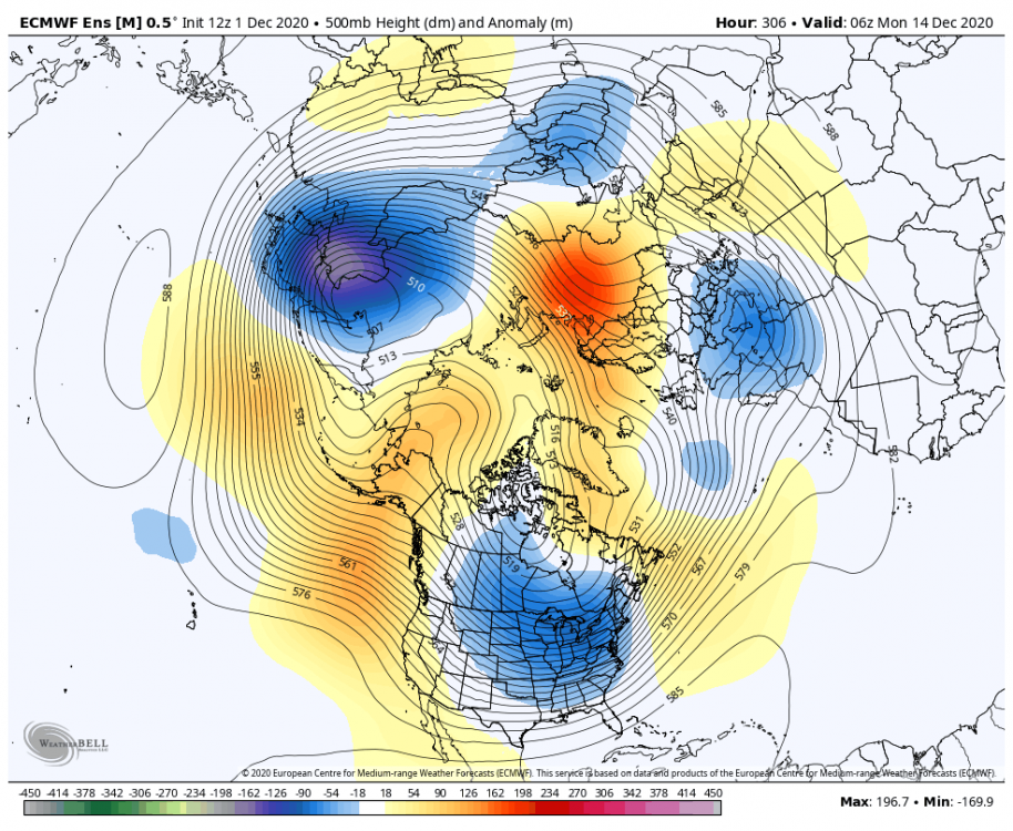
All the ensembles now bring a piece of the TPV into Canada. This is a result of the strat hit. Looks cold mid month with no Niña pattern in sight. Look at -epo on all three of Them -
December 2020 General Discussions & Observations Thread
Allsnow replied to bluewave's topic in New York City Metro
-
December 2020 General Discussions & Observations Thread
Allsnow replied to bluewave's topic in New York City Metro
What a look!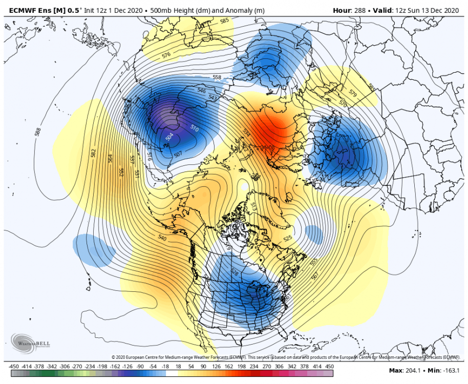
-
December 2020 General Discussions & Observations Thread
Allsnow replied to bluewave's topic in New York City Metro
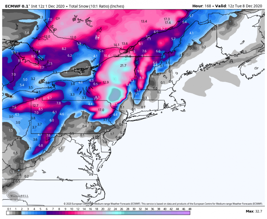
Eps 990 south of LI. Idv have some big hits for northeast PA up into UNY -
December 2020 General Discussions & Observations Thread
Allsnow replied to bluewave's topic in New York City Metro
Watch this costal take a perfect snow track and be rain for the coast. The airmass just blows -
December 2020 General Discussions & Observations Thread
Allsnow replied to bluewave's topic in New York City Metro
Wow.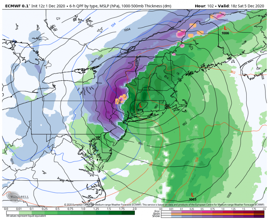
-
December 2020 General Discussions & Observations Thread
Allsnow replied to bluewave's topic in New York City Metro
-
December 2020 General Discussions & Observations Thread
Allsnow replied to bluewave's topic in New York City Metro
It’s a shame we can’t get the first shortwave to trend weaker because the energy diving in early next week is potent. It just gets buried now in the base of the trough. Sunday has potential in the far interior to produce snow -
December 2020 General Discussions & Observations Thread
Allsnow replied to bluewave's topic in New York City Metro
It’s finally here! -
December 2020 General Discussions & Observations Thread
Allsnow replied to bluewave's topic in New York City Metro
Nice snowstorm d12 on the gfs op. Fantasy range and will probably change but shows the potential with the pattern -
December 2020 General Discussions & Observations Thread
Allsnow replied to bluewave's topic in New York City Metro
Important tweet for the second half of December. The mjo wave in the Niña phases can’t gain strength because of the standing wave in IO -
December 2020 General Discussions & Observations Thread
Allsnow replied to bluewave's topic in New York City Metro
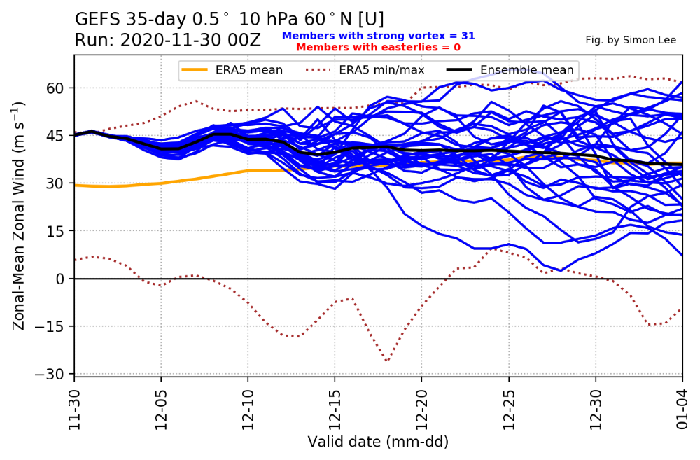
With those conflicting signals a wave 1 displacement of the SPV off the pole IMO will lead to a artic outbreak towards mid month. This is something that happen in 13/14 as punches were thrown at the vortex. I’m not calling for a 13/14 winter just that I expect colder air to come. This is supported by the eps and GEFS.
-
December 2020 General Discussions & Observations Thread
Allsnow replied to bluewave's topic in New York City Metro
So are day 10 operational models. They are always changing. So much for those Niña southeast ridge calls to start December Gef and eps continue to weaken the SPV by mid month.