Allsnow
-
Posts
26,462 -
Joined
-
Last visited
Content Type
Profiles
Blogs
Forums
American Weather
Media Demo
Store
Gallery
Everything posted by Allsnow
-

December 2020 General Discussions & Observations Thread
Allsnow replied to bluewave's topic in New York City Metro
This is a absolutely ridiculous post...did you mean to post this? -
December 2020 General Discussions & Observations Thread
Allsnow replied to bluewave's topic in New York City Metro
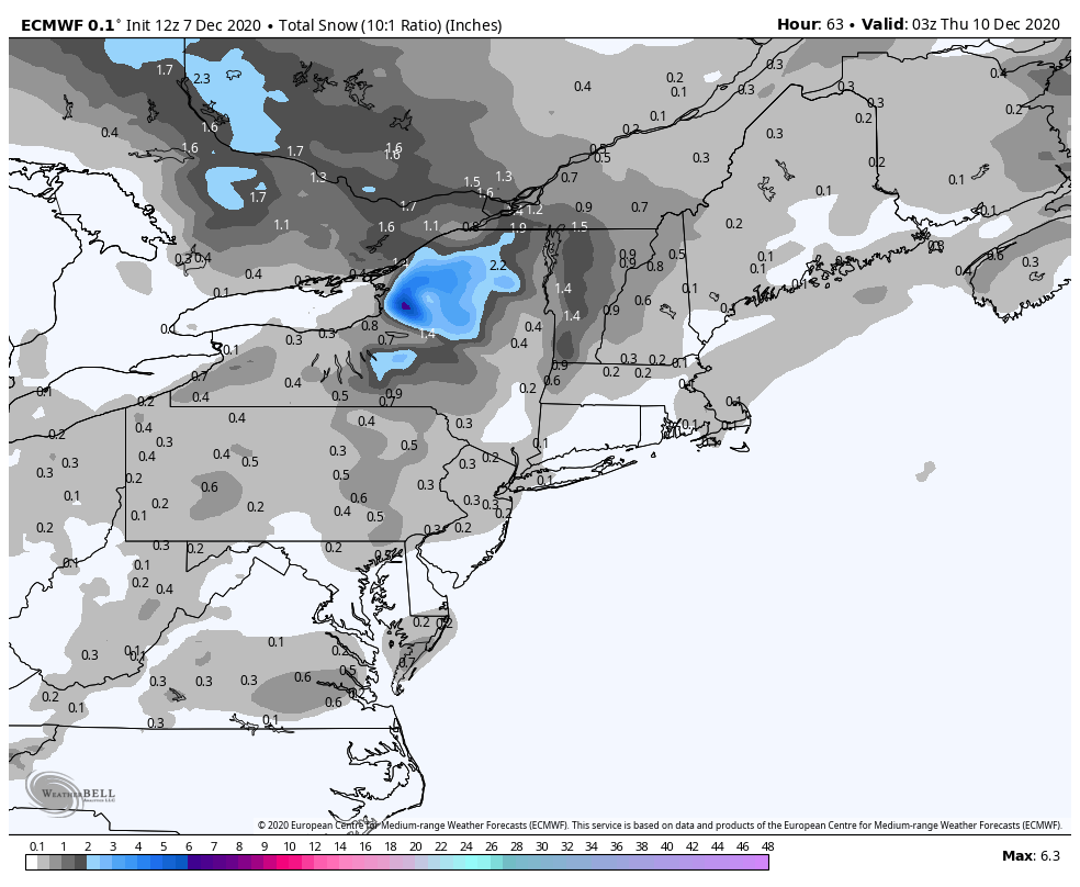
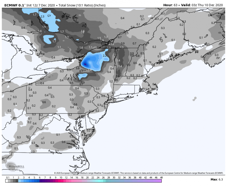
Light snow for nyc Wednesday morning.
-
December 2020 General Discussions & Observations Thread
Allsnow replied to bluewave's topic in New York City Metro
That’s a accurate chart of what’s going on currently. As of now no secondary peak is imminent. The eastern pac has actually warmed over the last few weeks. -
December 2020 General Discussions & Observations Thread
Allsnow replied to bluewave's topic in New York City Metro
-
December 2020 General Discussions & Observations Thread
Allsnow replied to bluewave's topic in New York City Metro
This isn’t going to be last winter where the PV gained strength and the mjo went wild at the end of December. The vortex is going to stay in Canada which will keep them cold. All we would need is something to buckle the flow to get the cold here. This December is acting more like a niño then Niña. Perhaps we get a niño January/February instead then. Who knows -
December 2020 General Discussions & Observations Thread
Allsnow replied to bluewave's topic in New York City Metro
Not according to the this. We peaked in October and will be moderate for the winter.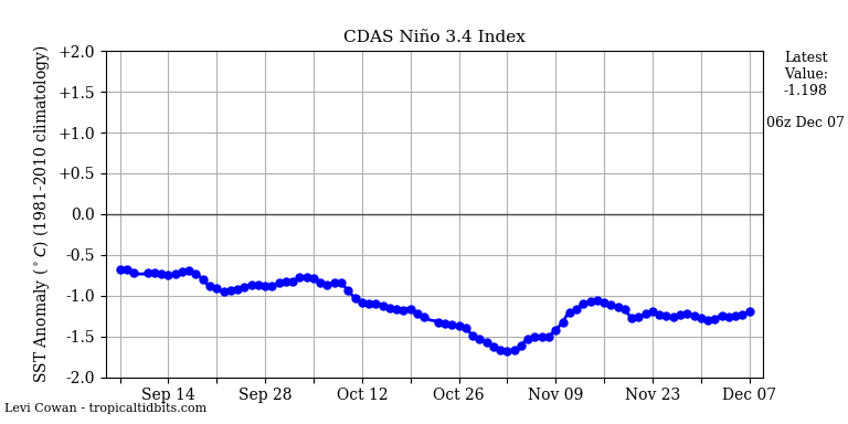
-
December 2020 General Discussions & Observations Thread
Allsnow replied to bluewave's topic in New York City Metro
Which was forecasted I believe from early last week. It was never supposed to be super below normal. The warmth was expected by the weekend. I believe I even posted about it. The following week won’t be cold because we lost the -epo look -
December 2020 General Discussions & Observations Thread
Allsnow replied to bluewave's topic in New York City Metro
I didn’t really say anything about cold in my post lol. I agree, lately it has been the theme. But I do think the models did a good job calling for this week to be cold. Its just going to be dry so no snow means nobody will care. -
December 2020 General Discussions & Observations Thread
Allsnow replied to bluewave's topic in New York City Metro
Yeah, I would favor above normal. If we can keep Canada cold (which it looks like) we should be okay going forward. This isn’t last winter where the Pv strengthened and mjo went crazy at the end of December. -
December 2020 General Discussions & Observations Thread
Allsnow replied to bluewave's topic in New York City Metro
Something to look at going forward is how the PV will start to weaken after mid month. The mjo is also to forecast to die off in 5. If we can get the Pv to control the pattern things could become more favorable end of December into January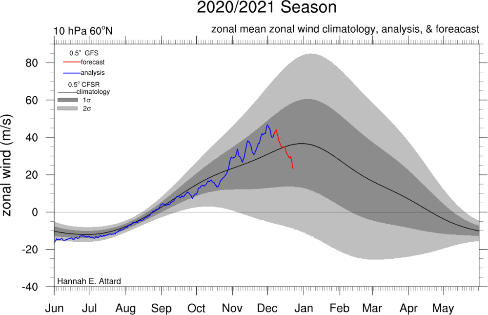
-
December 2020 General Discussions & Observations Thread
Allsnow replied to bluewave's topic in New York City Metro
The eps was breaking off a piece of the energy out west to try and keep us cool this weekend. It corrected earlier last week. -
December 2020 General Discussions & Observations Thread
Allsnow replied to bluewave's topic in New York City Metro
Not if we continue with a bad mjo and -AAM -
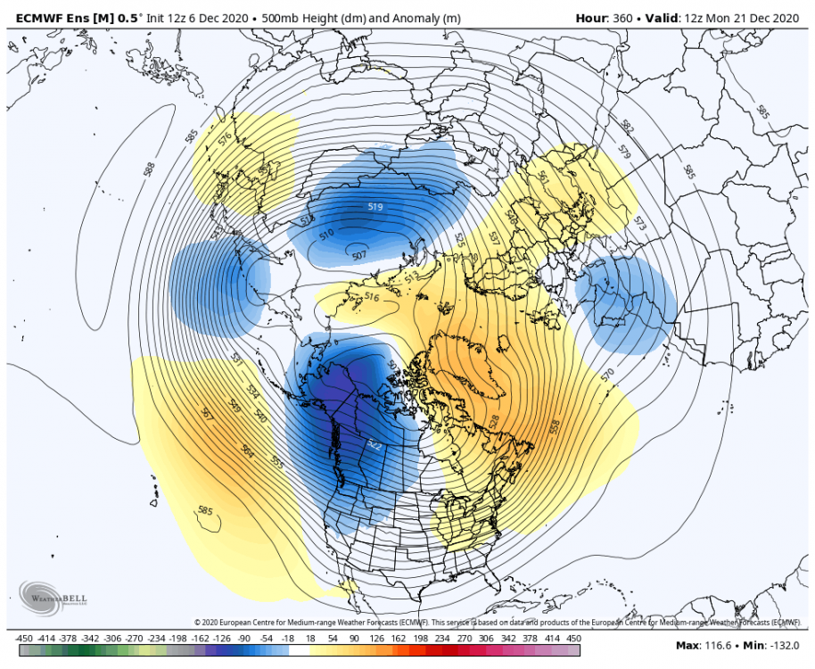
All I’m saying is it looks hostile around that timeframe. The mjo forcing is bad and the -AAM keeps the Niña look. I don’t think it’s a surprise that we are getting more of a Niña look for late December. TBD how bad it gets. As long as you keep the vortex in Canada you just need to buckle the flow. I’m not trying to steal your snow
-
December 2020 General Discussions & Observations Thread
Allsnow replied to bluewave's topic in New York City Metro
@michsnowfreak https://www.ecmwf.int/en/forecasts/charts/catalogue/ -
@bluewave I believe has a site where you can view it for free.
-
The pig isn’t in Ak. It’s still in Canada so it protects them from getting flooded with pac puke. If that would to happen you can write off the following two weeks IMO. Not saying I expect that
-
No, but the idea of the pattern getting awful around that time has support.
-
December 2020 General Discussions & Observations Thread
Allsnow replied to bluewave's topic in New York City Metro
No it didn’t... -
Yeah, it’s been a rough stretch down here as well. Kphl hasn’t had a inch of snow in 21 months
-
December 2020 General Discussions & Observations Thread
Allsnow replied to bluewave's topic in New York City Metro

-
Christmas looks toasty
-
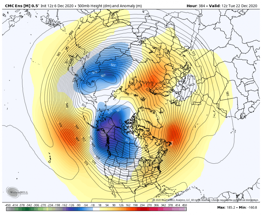
December 2020 General Discussions & Observations Thread
Allsnow replied to bluewave's topic in New York City Metro
-
The GEFS were the first to back away from the better look mid month. The eps continues to show a good pattern in the 11-15 until it went towards the GEFS yesterday. The models have been chasing this -epo/blocking pattern for a while now. In reality we just end up with more of the same. We really need something to shake things up.
-
December 2020 General Discussions & Observations Thread
Allsnow replied to bluewave's topic in New York City Metro
The MJO is croaking in 4/5 that’s not good for sustainable cold. We need something to shake the pattern up or it’s very meh. Lots of 40/50’s with rain -
December 2020 General Discussions & Observations Thread
Allsnow replied to bluewave's topic in New York City Metro
Yep. That ULL really produced at night for the 2nd part