Allsnow
-
Posts
26,462 -
Joined
-
Last visited
Content Type
Profiles
Blogs
Forums
American Weather
Media Demo
Store
Gallery
Everything posted by Allsnow
-

December 2020 General Discussions & Observations Thread
Allsnow replied to bluewave's topic in New York City Metro
With The wave 1 strat hit expect growing confidence of a artic outbreak towards mid month.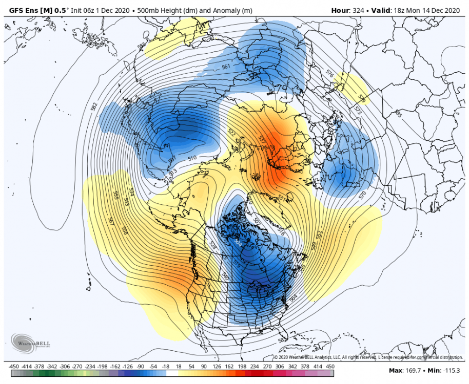
-
December 2020 General Discussions & Observations Thread
Allsnow replied to bluewave's topic in New York City Metro
GEFS like the eps is pushing the TPV towards Hudson Bay

-
December 2020 General Discussions & Observations Thread
Allsnow replied to bluewave's topic in New York City Metro
Those are operational runs at day 10. They will always be changing. Use the ensembles that far out. -
December 2020 General Discussions & Observations Thread
Allsnow replied to bluewave's topic in New York City Metro
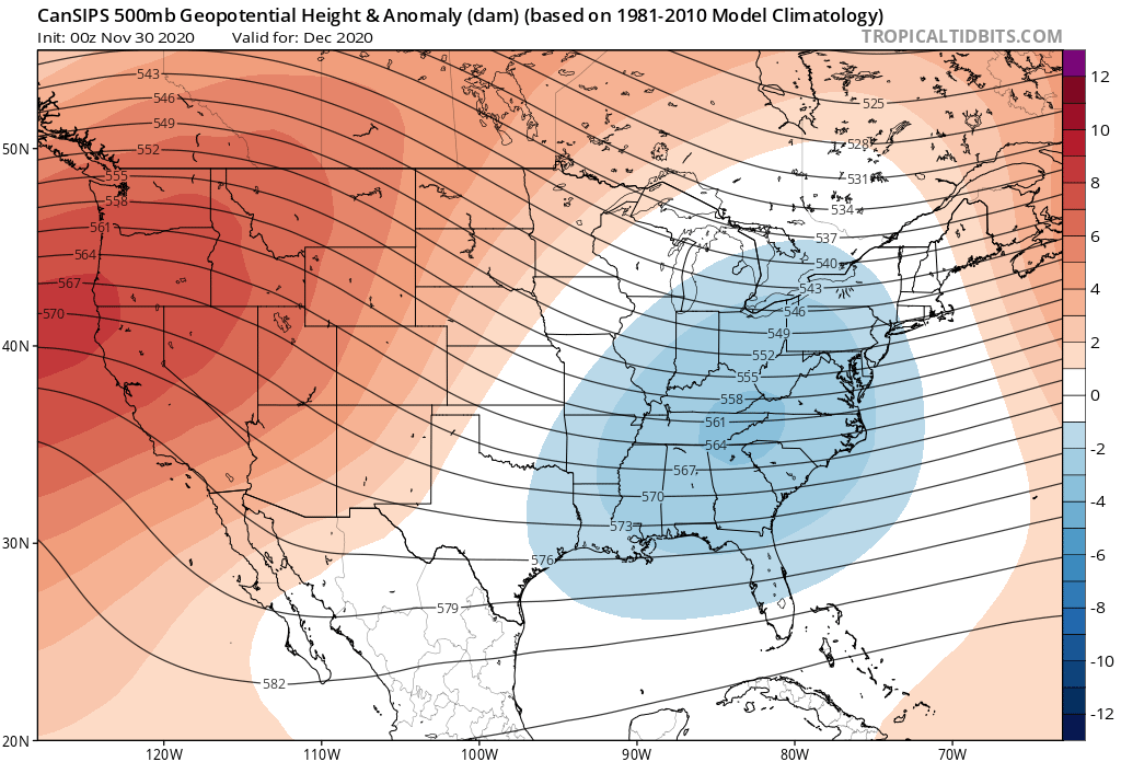
December pattern on the cansips now. That’s a quick change
-
December 2020 General Discussions & Observations Thread
Allsnow replied to bluewave's topic in New York City Metro
Pretty nice euro run overnight that offers snow chances. The pattern also looks great after the pna ridge rolls forward and we get more of a -epo/-nao pattern
-
We keep kicking the can in the Niña pattern. Let’s hope it stays in week 4-5 fantasyland
-
December 2020 General Discussions & Observations Thread
Allsnow replied to bluewave's topic in New York City Metro
It’s silly to look at that extended model with any type of seriousness -
December 2020 General Discussions & Observations Thread
Allsnow replied to bluewave's topic in New York City Metro
-
December 2020 General Discussions & Observations Thread
Allsnow replied to bluewave's topic in New York City Metro
That’s the gfs -
December 2020 General Discussions & Observations Thread
Allsnow replied to bluewave's topic in New York City Metro
-
December 2020 General Discussions & Observations Thread
Allsnow replied to bluewave's topic in New York City Metro
@NEG NAO closer look at the system the euro has. If we get the northern stream to dive in then it can work. The southern energy alone won’t cut it with temps -
December 2020 General Discussions & Observations Thread
Allsnow replied to bluewave's topic in New York City Metro
That’s not the storm he is talking about. The storm for the 5th is a non event on the euro. -
I remember March 14 was real cold/dry. We had MJO phases 5/6 (cold in March) and a lobe of the Pv sat over Maine. Lol
-
December 2020 General Discussions & Observations Thread
Allsnow replied to bluewave's topic in New York City Metro
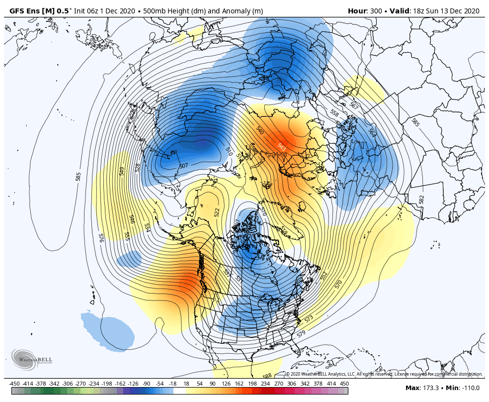
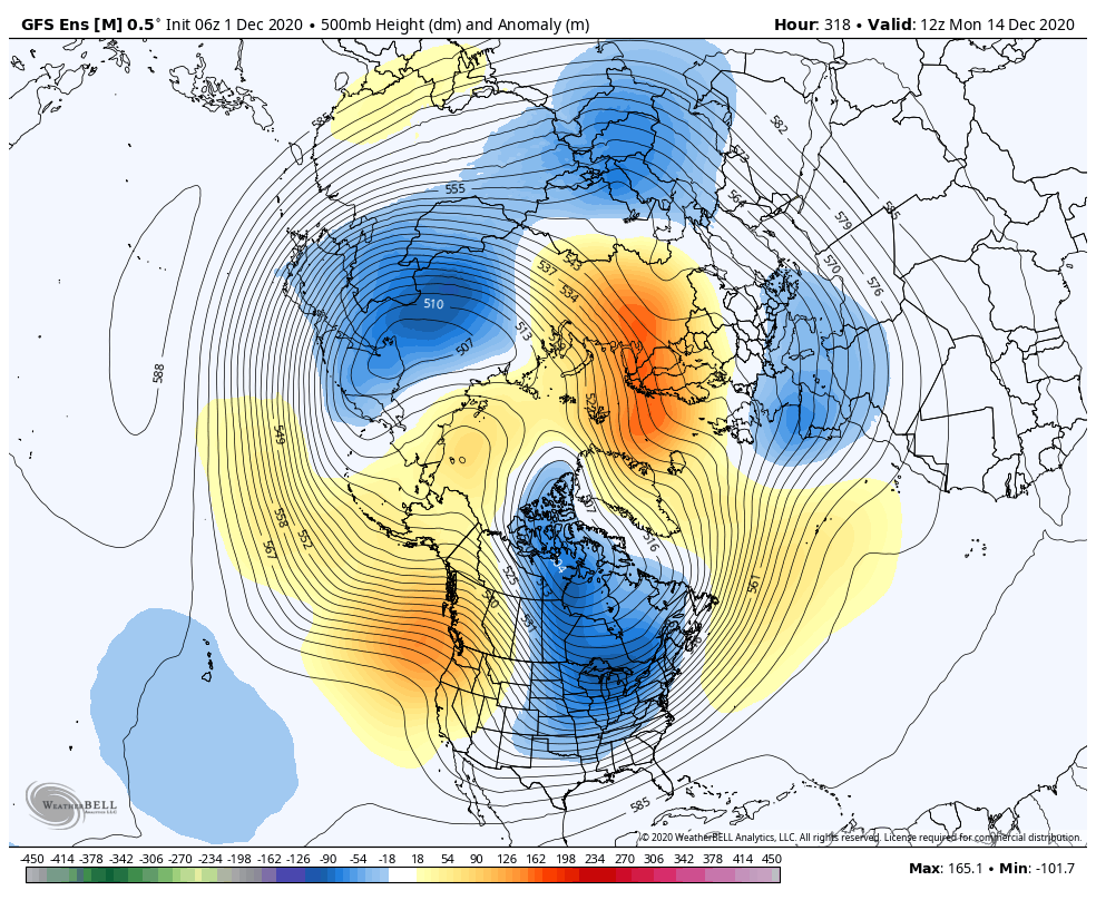
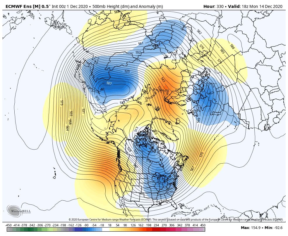
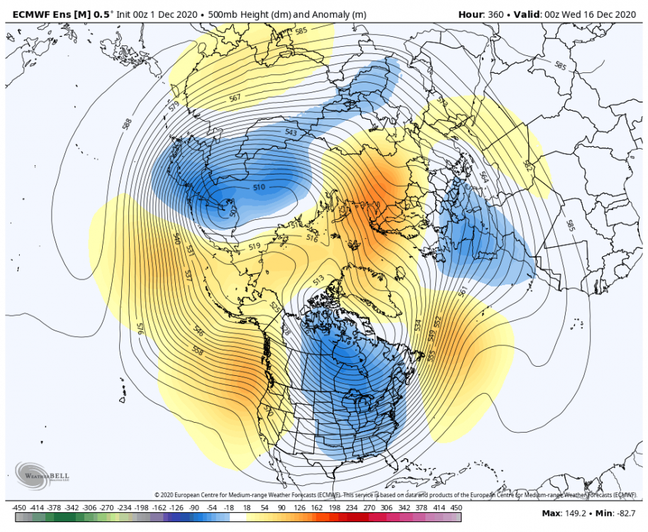
Some real nice looks on the ensemble guidance for December. Both the eps and GEFS have the ridge kissing the west coast going up into the pole -
Absolutely. 13/14 was filled with jabs on a weak Pv we never had a SSW.
-
December 2020 General Discussions & Observations Thread
Allsnow replied to bluewave's topic in New York City Metro
That system has no chance to be snow here. The 12z euro doesn’t even have a storm for the 5th now. We need to watch the energy diving into the trough between the 7-8th as that has potential with cold around -
Yeah. Usually means a shot of artic air is coming into states. We don’t need a split to sustained winter. 13/14 was filled with jabs to the Pv
-
Looks like a bit of a reshuffle in between the 10th-12th. Something models have pick up on as the ridge retrogrades off the west coast.
-
December 2020 General Discussions & Observations Thread
Allsnow replied to bluewave's topic in New York City Metro
This is the first period to watch. Virtual snow for bluewave -
We are definitely going to get more of a Niña pattern for the second half of the month. With the eps look, I definitely could see that typical Niña snow gradient. We will have cold around with chances. I just hope we can keep the southeast ridge at bay, selfishly for my location. I would much rather be in Sne then nj for this lol.
-
Yeah, eps was more of a -epo pattern with overrunning/quick hitting stuff. The GEFS have the -epo along with -+pna which would provide a higher ceiling. Hopefully we get a compromise between the two.
-
December 2020 General Discussions & Observations Thread
Allsnow replied to bluewave's topic in New York City Metro
I would watch the Sunday into Tuesday timeframe. Lots of energy diving into the trough with cold around. -
The vortex is positioned nicely to get cold down here, unlike last year.
-
-
November 2020 General Discussions & Observations Thread
Allsnow replied to Rtd208's topic in New York City Metro
@donsutherland1 where does November rank for the other major climate zones in the northeast? Orh,bos, and phl