Allsnow
-
Posts
26,462 -
Joined
-
Last visited
Content Type
Profiles
Blogs
Forums
American Weather
Media Demo
Store
Gallery
Everything posted by Allsnow
-
January 2019? I believe we had a southern slider that dropped 6-12 in the mid Atlantic
-

December 2020 General Discussions & Observations Thread
Allsnow replied to bluewave's topic in New York City Metro
That’s because the models were figuring out where the low pressures were. It was only cold underneath the cutoffs -
December 2020 General Discussions & Observations Thread
Allsnow replied to bluewave's topic in New York City Metro
Yeah. Winter has been out west the last two years. A Niña like pattern will do that. Their has not been much winter outside of Maine in the east. -pna/dateline ridge/ strong vortex is a recipe for cutters -
December 2020 General Discussions & Observations Thread
Allsnow replied to bluewave's topic in New York City Metro
Eps continues to look great after the 5th. We even get some poleward ridging with a hint of a -nao. So about that Niña December? Lol -
December 2020 General Discussions & Observations Thread
Allsnow replied to bluewave's topic in New York City Metro
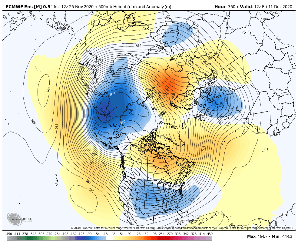
That’s a overrunning pattern imo. A full blown Niña look would have a ridge in the Aleutians. We also have a hint of a -nao with a split flow. This is the Niña composite for December p5 -
December 2020 General Discussions & Observations Thread
Allsnow replied to bluewave's topic in New York City Metro
We missed one storm last December because surface temps were between 33-34. -
December 2020 General Discussions & Observations Thread
Allsnow replied to bluewave's topic in New York City Metro
I would need a new shovel by now if we received all the virtual snow the models had the last two years. IMO that means nothing -
December 2020 General Discussions & Observations Thread
Allsnow replied to bluewave's topic in New York City Metro
Still not signs of a Niña pattern or southeast ridge on the ensembles -
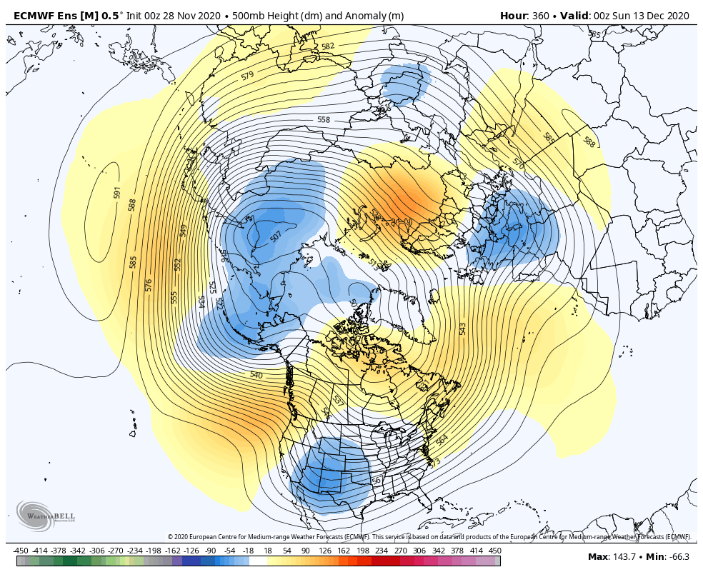
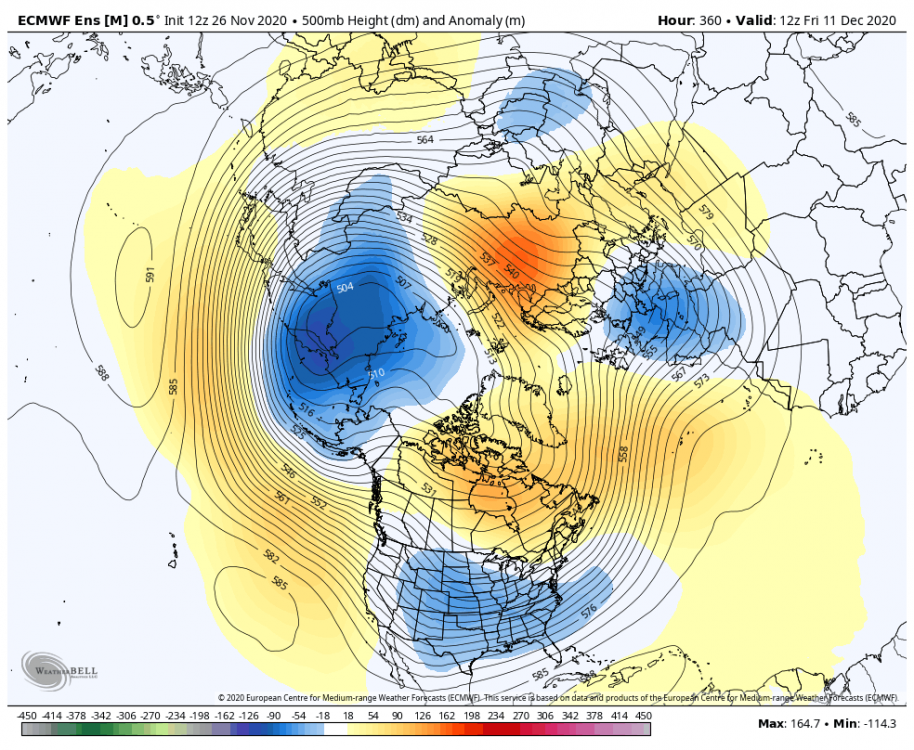
This is not a bad look at the eps. This snap shot Is after the ridge retrogrades west. It’s more of a overrunning threat with some high lat blocking. It’s definitely not the GEFS but not a Niña look yet.

-
The first two systems never had a chance for us. Hopefully we get a threat in 5th-10th timeframe with a better airmass
-
December 2020 General Discussions & Observations Thread
Allsnow replied to bluewave's topic in New York City Metro
So you’re saying no snowfall for the entire month of December? -
December 2020 General Discussions & Observations Thread
Allsnow replied to bluewave's topic in New York City Metro
-
December 2020 General Discussions & Observations Thread
Allsnow replied to bluewave's topic in New York City Metro
-
December 2020 General Discussions & Observations Thread
Allsnow replied to bluewave's topic in New York City Metro
-
December 2020 General Discussions & Observations Thread
Allsnow replied to bluewave's topic in New York City Metro
Nice post. Overall I’m more positive for this winter then I was a month ago. I don’t think 95/96 is walking into the door but 11/12 isn’t either -
December 2020 General Discussions & Observations Thread
Allsnow replied to bluewave's topic in New York City Metro
The Niña will not make it to strong status and it looks like we are near peak
-
December 2020 General Discussions & Observations Thread
Allsnow replied to bluewave's topic in New York City Metro
Yep. Niña look comes back week 4. Week 3 looks great with pna and -nao. -
Lol. That’s good
-
Yeah, that’s at the very end of the run. I just would have liked to see some higher hgts in Ak. We lost the Aleutian low. But as @ORH_wxman said the pna is nice before the end of the run
-
Meh
-
December 2020 General Discussions & Observations Thread
Allsnow replied to bluewave's topic in New York City Metro
This is what I mean with the ridge moving west and establishing a cross Polar flow/-epo. All the ensembles don’t roll the ridge over which would pump the southeast ridge. -
December 2020 General Discussions & Observations Thread
Allsnow replied to bluewave's topic in New York City Metro
-
December 2020 General Discussions & Observations Thread
Allsnow replied to bluewave's topic in New York City Metro
-
December 2020 General Discussions & Observations Thread
Allsnow replied to bluewave's topic in New York City Metro
I think our best shot of snow will be as the pna ridge starts to retrograde west into Ak. This will allow colder air to enter the eastern US. With a active southern jet and colder air in Canada we will have our chances. I welcome this pattern change as it’s diff then anything we have seen in the last two years. -
I think our best shot is when the pna ridge starts to move west. It will allow colder air into Canada and the southeast ridge will still be a bay, at least at first.