wdrag
-
Posts
5,603 -
Joined
-
Last visited
Content Type
Profiles
Blogs
Forums
American Weather
Media Demo
Store
Gallery
Everything posted by wdrag
-
Reminder on why threads for NYC CP may be started below advisory level expectations. From a weather underground publication - Nov 1 2025: 6. You should pay close attention to light snowfall forecasts too: It's human nature to focus on the snow forecasts with high amounts, or just the highest total in, say, a "three to six-inch" forecast. But don't underestimate the hazard from light snow. According to a study released in 2019, 54% of deadly snow-related traffic accidents in the U.S. occurred where snowfall was too light or didn't last long enough to prompt the National Weather Service to issue a winter storm warning or winter weather advisory.

-
We as a science of modeling are not good beyond two weeks... missing out on the extremes potential. Most on here will see marked improvements later this century. Todays D6 is about as good as the D1 when I was kid in the late 50s.
-
What we know when we look back.. Blend of Model gust tool was 15 MPH conservative---just not a valid-useful product for this situation. I even checked the 19z issuance yesterday--- cant use it for this kind of CAA pattern with 35 MB difference between the departing New England low and the Central Plains high pressure system.
-
Was still blasting well after midnight... max gusts since 2AM this morning. Also news accounts of trees down in Queens etc. KACK: Nantucket, Nantucket Memorial Airport, MA, United States [48kt, 25m/s] KBDR: Bridgeport, CT, United States [45kt, 23m/s] KBOS: Boston, Logan Intl Arpt, MA, United States [43kt, 22m/s] KBVY: Beverly, Beverly Municipal Airport, MA, United States [42kt, 22m/s] KCQX: Chatham, Chatham Municipal Airport, MA, United States [42kt, 22m/s] KEWB: New Bedford, New Bedford Regional Airport, MA, United States [41kt, 21m/s] KEWR: Newark, Newark Intl Arpt, NJ, United States [46kt, 24m/s] KFOK: Westhampton Beach, NY, United States [43kt, 22m/s] KFRG: Farmingdale, Republic Airport, NY, United States [44kt, 23m/s] KGON: Groton/New London, CT, United States [47kt, 24m/s] KHPN: White Plains, NY, United States [41kt, 21m/s] KHWV: Shirley, Brookhaven Airport, NY, United States [43kt, 22m/s] KISP: Islip, Long Island Mac Arthur Airport, NY, United States [43kt, 22m/s] KJFK: JFK Intl Arpt, NY, United States [42kt, 22m/s] KLGA: New York, La Guardia Airport, NY, United States [47kt, 24m/s] KMDT: Harrisburg, Harrisburg Intl Arpt, PA, United States [40kt, 21m/s] KMTP: Montauk, Montauk Airport, NY, United States [41kt, 21m/s] KNHK: Patuxent River, Naval Air Stn, MD, United States [43kt, 22m/s] KOQU: N. Kingston / Quonset, RI, United States [45kt, 23m/s] KORH: Worcester, Worcester Regional Airport, MA, United States [44kt, 23m/s] KPVC: Provincetown, MA, United States [43kt, 22m/s] KPVD: Providence, RI, United States [44kt, 23m/s]
- 68 replies
-
- 1
-

-
- wind damage
- power outages
- (and 1 more)
-
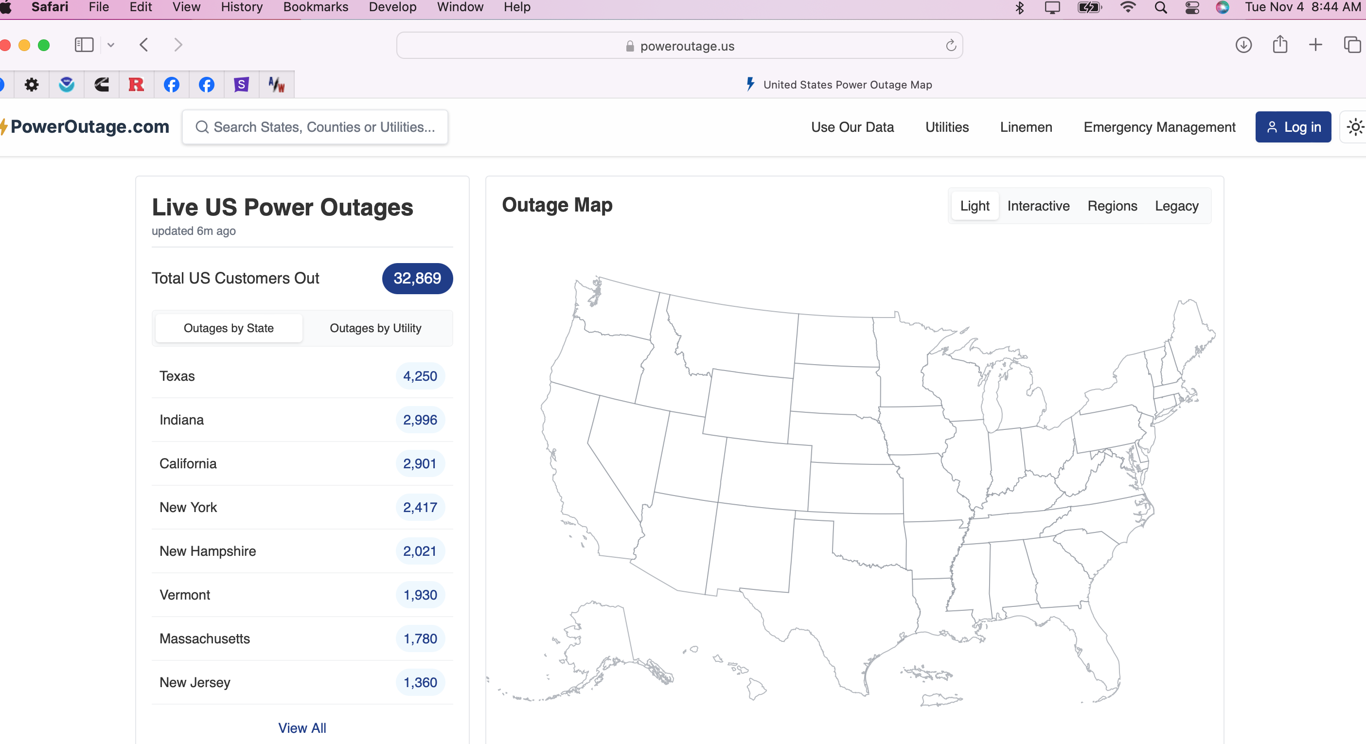
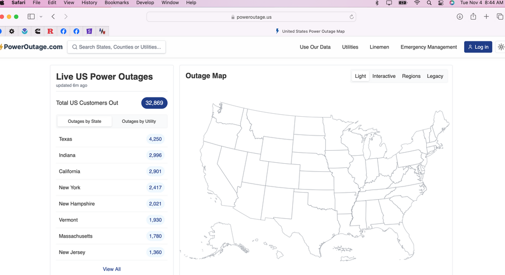
Meters without power at midnight... Pennsylvania87,394 New Jersey15,711
- 68 replies
-
- 1
-
-
- wind damage
- power outages
- (and 1 more)
-
That above shows max gusts around NYC metro around 54-55 MPH, LGA and TEB. Most ASOS 45-50 MPH in our subforum.
-
Past 3 hrs sampler... max gusts. (NYS MESONET and NJ CLIMATE sites less) KAVP: Wilkes-Barre/Scranton, PA, United States [47kt, 24m/s] KBGM: Binghamton, Binghamton Regional Airport, NY, United States [49kt, 25m/s] KBWI: Baltimore, MD, United States [41kt, 21m/s] KCDW: Caldwell, Essex County Airport, NJ, United States [43kt, 22m/s] KCXY: Harrisburg, Capital City Airport, PA, United States [47kt, 24m/s] KDCA: Reagan National Airport, DC, United States [40kt, 21m/s] KDUB: Dubois, WY, United States [47kt, 24m/s] KEKN: Elkins, WV, United States [40kt, 21m/s] KEWR: Newark, Newark Intl Arpt, NJ, United States [42kt, 22m/s] KFRG: Farmingdale, Republic Airport, NY, United States [42kt, 22m/s] KHGR: Hagerstown, MD, United States [45kt, 23m/s] KHLG: Wheeling, Wheeling Ohio County Airport, WV, United States [42kt, 22m/s] KILG: Wilmington, New Castle County Airport, DE, United States [41kt, 21m/s] KIPT: Williamsport, PA, United States [45kt, 23m/s] KISP: Islip, Long Island Mac Arthur Airport, NY, United States [40kt, 21m/s] KJFK: JFK Intl Arpt, NY, United States [41kt, 21m/s] KLGA: New York, La Guardia Airport, NY, United States [47kt, 24m/s] KLNS: Lancaster, Lancaster Airport, PA, United States [47kt, 24m/s] KMGJ: Montgomery, Orange County Airport, NY, United States [40kt, 21m/s] \\ KMPO: Mount Pocono, PA, United States [49kt, 25m/s] KMRB: Martinsburg, WV, United States [40kt, 21m/s] KNEL: Lakehurst, NJ, United States [40kt, 21m/s] KPHL: Philadelphia, Philadelphia Intl Arpt, PA, United States [48kt, 25m/s] KRDG: Reading, Reading Regional Airport, PA, United States [44kt, 23m/s]] KSEG: Selinsgrove, Penn Valley Airport, PA, United States [42kt, 22m/s] KSMQ: Somerville, NJ, United States [43kt, 22m/s] KTEB: Teterboro, Teterboro Airport, NJ, United States [48kt, 25m/s] KWRI: Mcguire AFB, NJ, United States [41kt, 21m/s]
- 68 replies
-
- 2
-
-
- wind damage
- power outages
- (and 1 more)
-
At least 5 stations in PA-NYS Apps westward are gusting 40-47KT near 7PM. Not sure how this will translate to our area and my confidence is less than yesterday for the thread headline but it will be a close for iso 50 KT easter LI I think. Power outages 7PM as a baseline. Pennsylvania6,439 New York4,518
- 68 replies
-
- 1
-
-
- wind damage
- power outages
- (and 1 more)
-
There has been some small decrease in modeled winds tonight... I think the advisory covers it. 45 KT at BUF recently at 40 KT JST. Slowly increasing,
-
No changes from my view on the coming wind event tonight. Please continue to follow NWS advisories-warnings. I'll try and post info later this evening. May slightly update the thread headline at 5PM but otherwise all damage OBS in this thread tonight-thanks. Overall trend since yesterday, imo is wind advisory 40-45 kt gusts for 1-3 hours, except warning 50 KT ridges and eastern LI.
- 68 replies
-
- 1
-
-
- wind damage
- power outages
- (and 1 more)
-
00z/5 CMCE and EPS offer a widespread light snow cover to the I84 corridor around 11/10. Could be this amplifying 5H trough crossing the east coast or the following Alberta clipper around 11/12-13. Also, I think at least one or 2 more wind advisory events between 11/10-11/16.
-
Thread started for tomorrow night... might need pinning? Thank you very much. OBS for the wind event will go right into this thread...I'll probably adjust it for OBS in the headline at 6PM tomorrow.
-
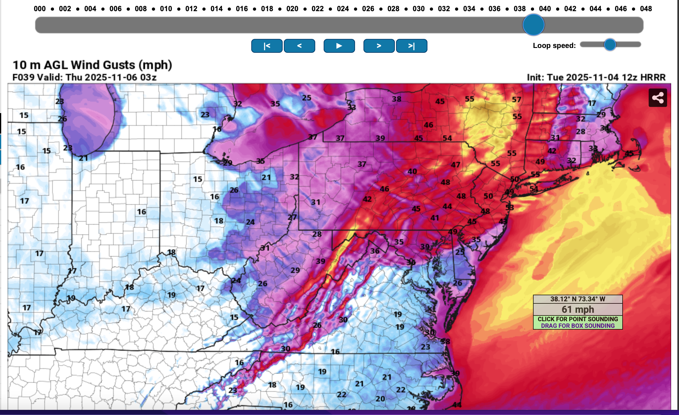
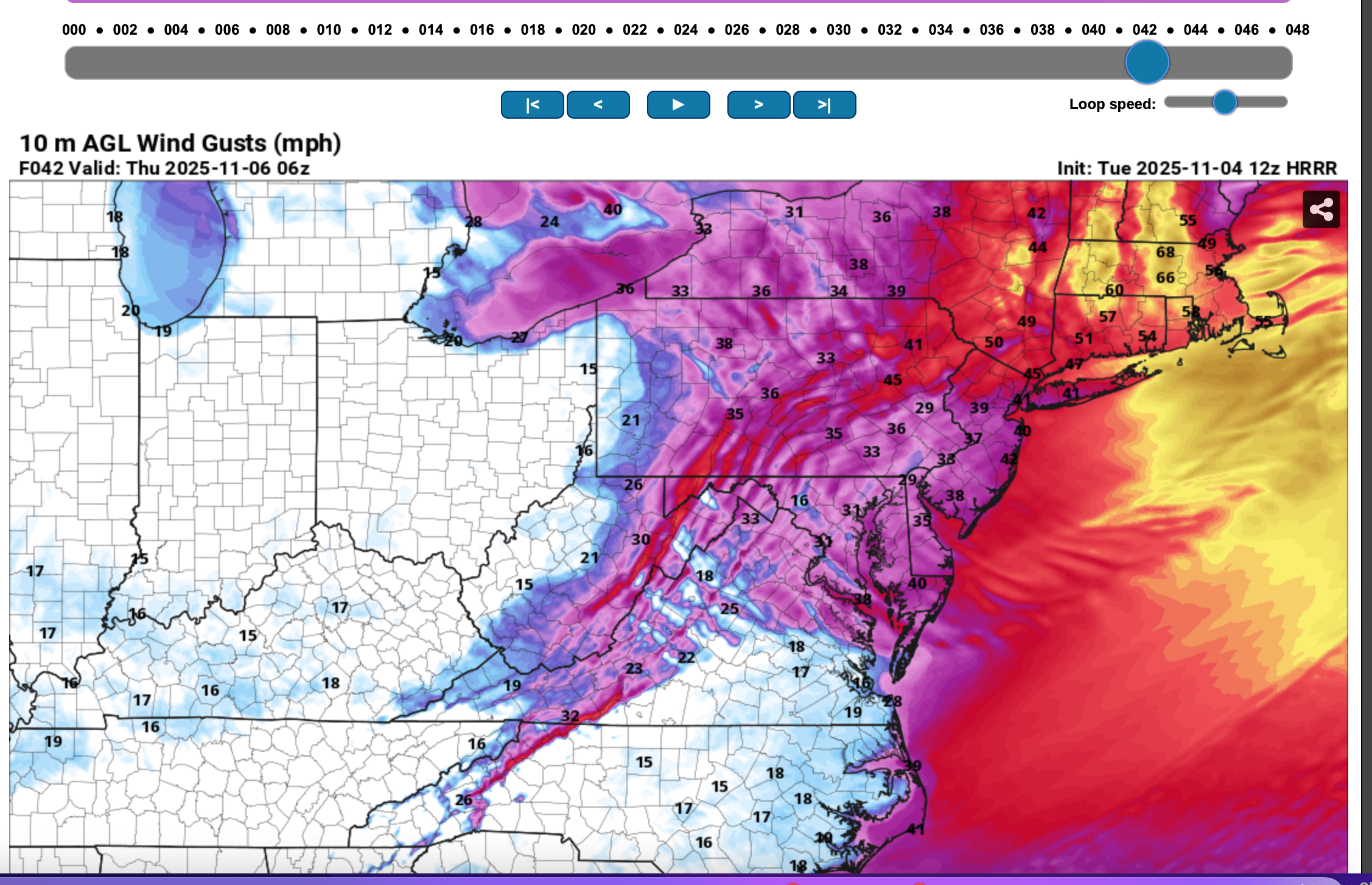
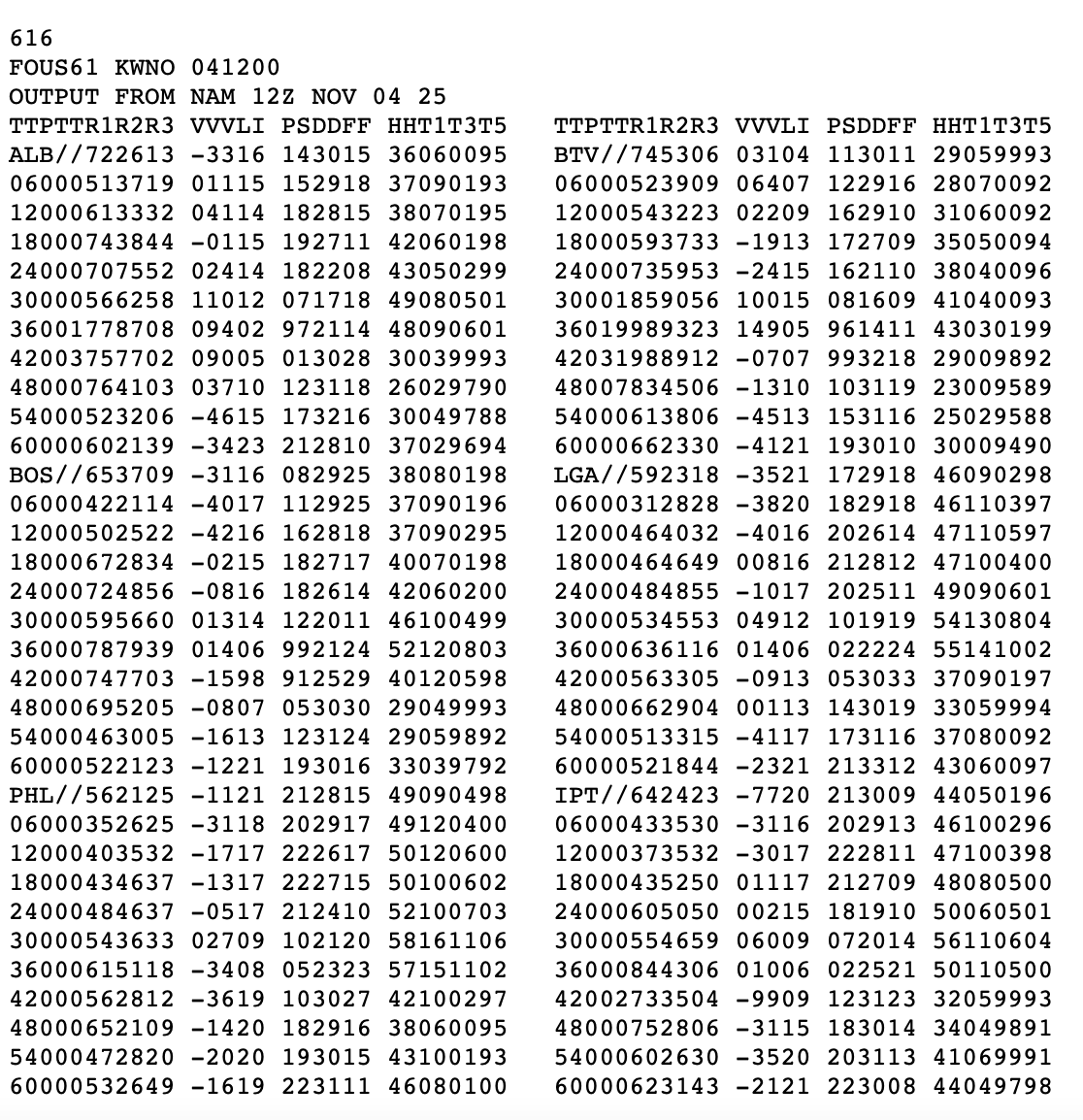
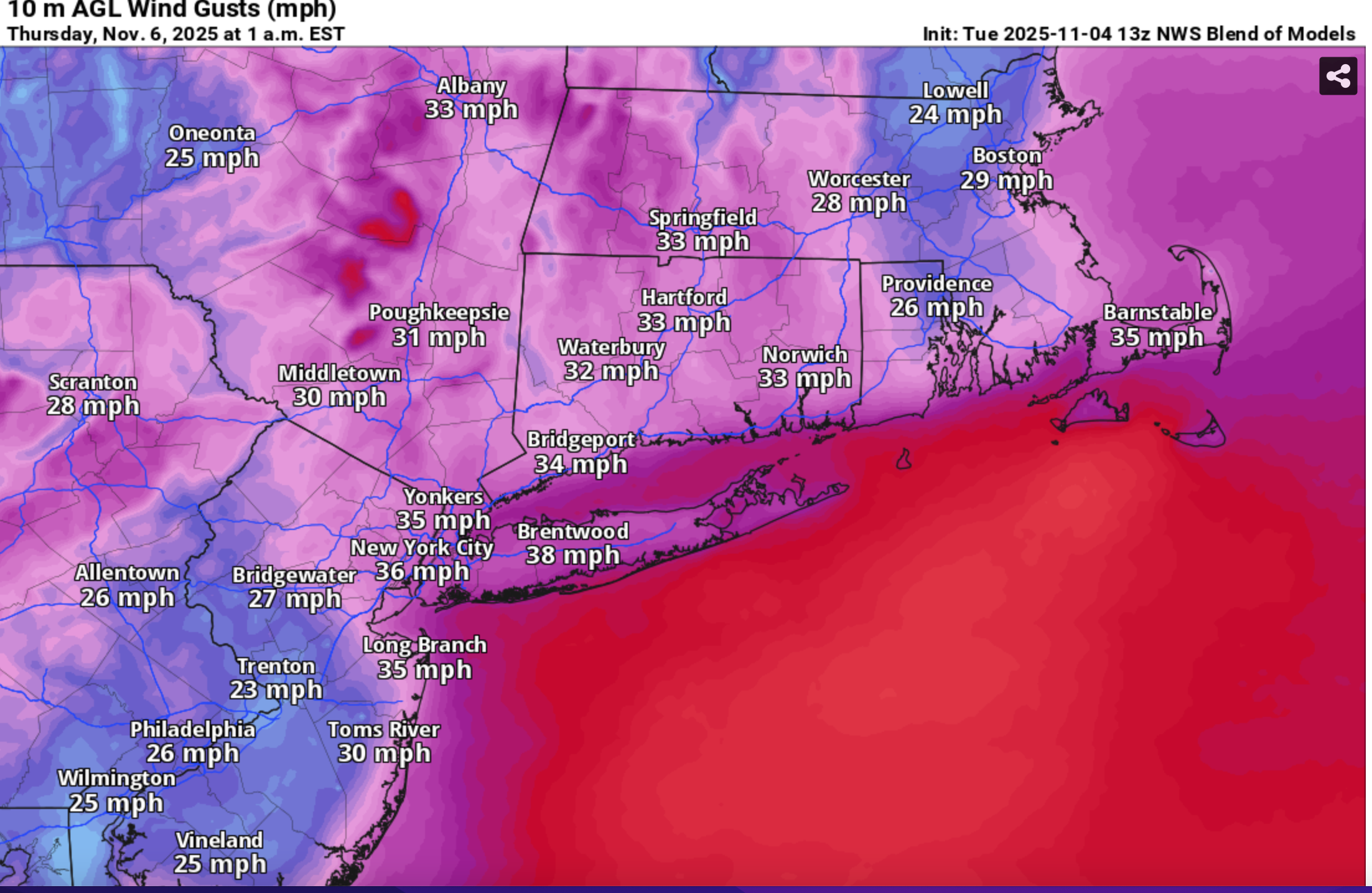
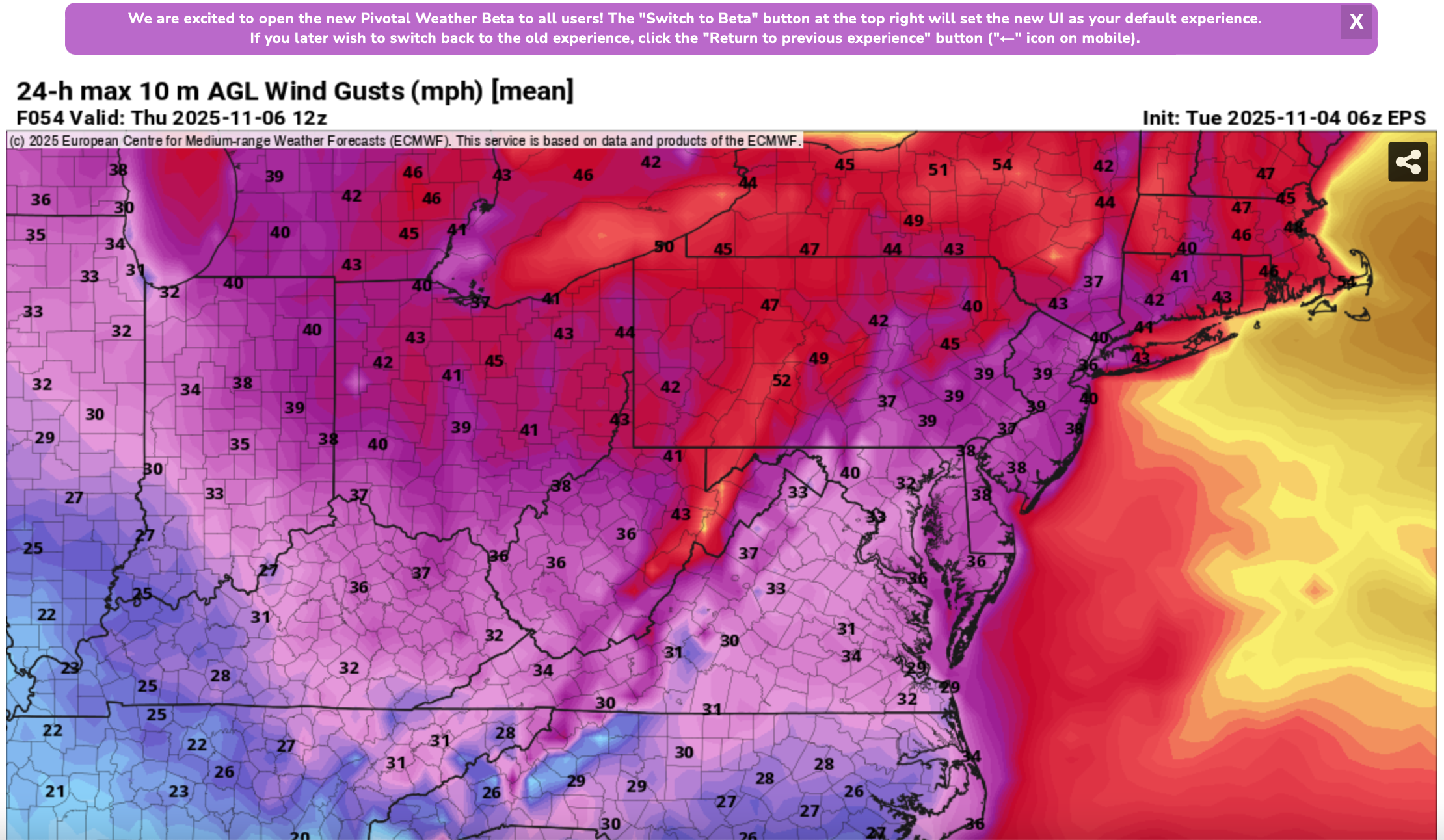
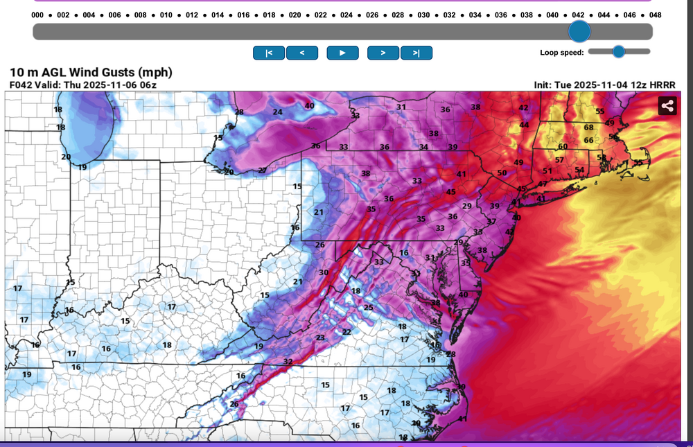
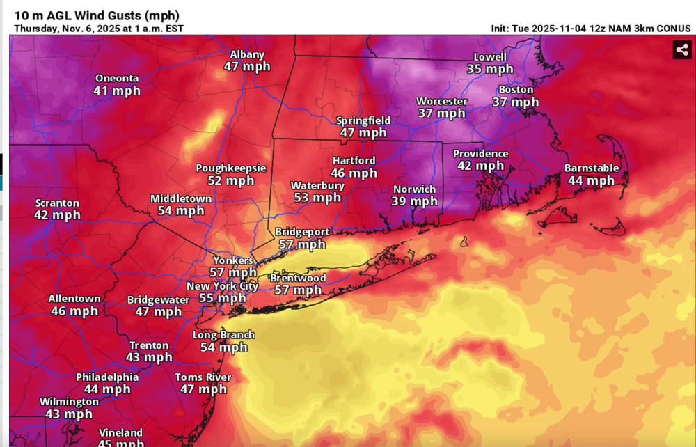
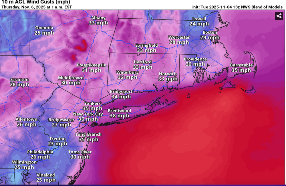
Please follow whatever NWS OKX PHI ALY and BOX issues on the coming Wednesday night wind and tides. From our subforum standpoint have tagged wind damage for Wednesday night's brief but significant wind event associated with a 55-65KT 850 MB Cold Air Advection jet overhead. No guarantees, so the worst case 12z/4 HRRR and NAM suite max wind gusts should be 5 MPH too high but nevertheless, we should see more power outages than this morning (attached), and I expect at least a few night time -Thursday morning detours travel delays due to downed tree branches especially ridges and through NYS-CT. This will impact air travel for arrival departures Wednesday evening possibly into Thursday morning. Lapse rates look unstable for a few hours Wednesday evening up to at least 900MB, with strong subsidence drying in the wake of the Wednesday evening cold frontal passage adding to momentum transfer. A 12 hour 500MB HFC of over 150M amplifies in its east-southeast trek across NYS into New England Wednesday evening, briefly increasing the nw 850MB jet behind it to 65 kt or a bit higher. PA/NJ look to be on the southern fringe of the greatest impact which should be NYS and New England. It's an early call so no guarantees but I think its worth an eventual wind Watch or Advisory. I expect at least half the airports in the NYC metro area to hit at least 40 kt, possibly reaching 50 KT? Wind gust potential diminishes rapidly in our NYC subforum area by dawn Thursday. BLOWOUT Tide Thursday morning?: There is a chance that parts of the east facing coasts at just after midnight Thursday morning's LOW tide cycle will see a blow out tide less than -1.6' MLLW because of this brief period of wnw wind. Added HRRR max gusts at 10P/5 and 1A/6, the 12z/4 FOUS with my own personal trigger of 27KT BL wind as a threshold of wind event concerns, the 844AM today power outages with the relatively light sub 40KT gusts. Then I added the 3K NAM sampler max wind gusts, the more conservative Blend Of Models wind gust forecast and the the EPS marginal advisory wind gust modeled prediction. 1058A/4


- 68 replies
-
- 5
-

-
-
- wind damage
- power outages
- (and 1 more)
-
Wind advisory potential continues Wednesday night...40-50 MPH gusts, near 60 briefly on the ridges. Power outages of some sort return. Might need some predawn Thu detours to destinations. Not sure of the power outages count Wed night... not major but not nil either. Blowout tide potential both low tides Thu as we move into lunar larger tide cycles. No thread til or if OKX issues.
-
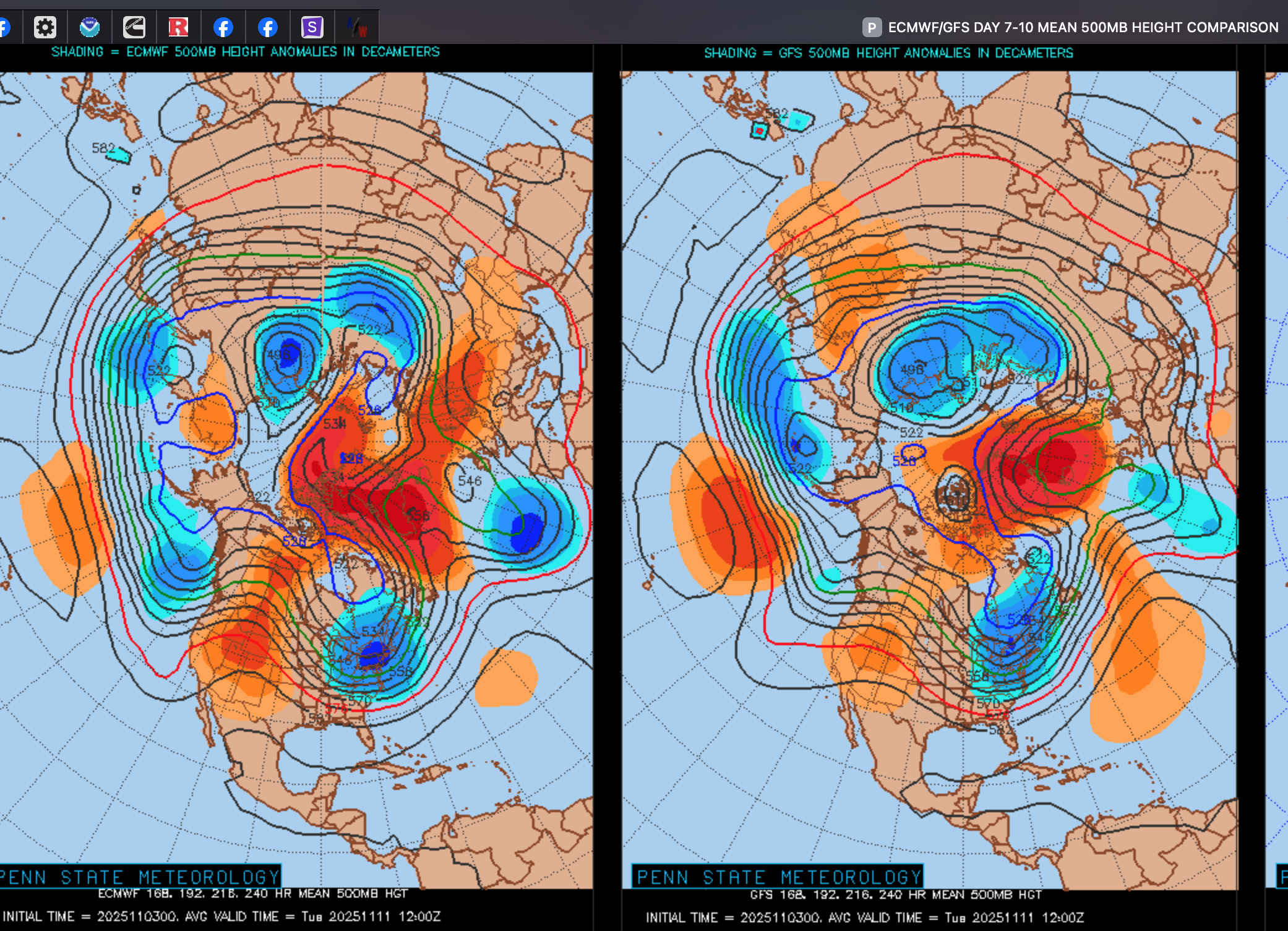
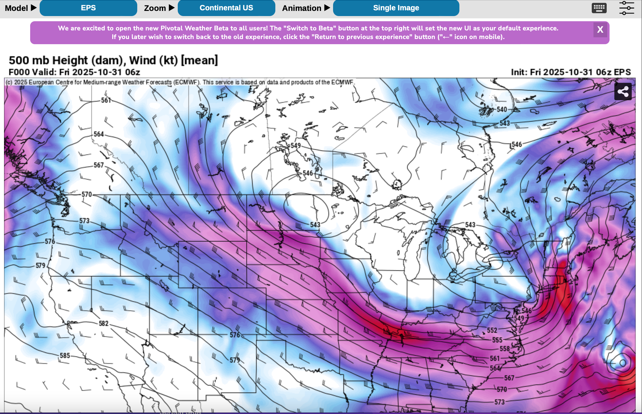
I need to make a correction to my stmt 2 days ago: "block now gone". The block reforms Greenland and northern Canada Thursday (6th) onward and should linger through at least the 15th I need to keep two things in mind... 1) it's further N than the one we just finished this past week so still looks like N of 40N lows (not pressing storm track far enough south) 2) NO southern streamer short wave so far and so I think we're going to need the block to depress (relocate further s than now projected). We need the southern streamer for a coastal low Am looking to sometime between Sun Nov 9-Thursday Nov 13 for a first possible widespread minor snow cover, on grass, INLAND II84 corridor. Not unusual for first time in Nov. I liked Don's snow stats through Nov 15 in CP... but for now I cant see anything more than a T in the air if we get lucky. In the meantime: sort of looks to me like a wind advisory event Wed night-Thu morning Nov 5-6 Subsequently maybe a BLOWOUT tide Thursday morning? I added the 7-10day 00z/3 MEAN 5H.. block evident but a little far north, I think.

-
I look back at these sensor wind gusts... Just seemed to me much more power outages, normally associated with somewhat higher gusts. Need a study of wind gusts with soil moisture, leaf status, direction (east vs nw or w)
-
From Mt Holly for nearby NJ/PA ...Hunterdon County... Readington 40 MPH 0154 PM 10/31 AWOS ...Mercer County... Trenton 48 MPH 0515 PM 10/31 ASOS ...Middlesex County... Perth Amboy 46 MPH 0109 PM 10/31 WXFLOW ...Monmouth County... 1.0 NW Keansburg 47 MPH 1257 PM 10/31 HADS Sea Girt 44 MPH 1150 AM 10/31 NJWXNET SEA BRIGHT 43 MPH 1240 PM 10/31 CWOP Monmouth 43 MPH 0203 PM 10/31 WXFLOW Cream Ridge 41 MPH 0150 PM 10/31 NJWXNET Belmar Farmdale 40 MPH 0308 PM 10/31 AWOS ...Morris County... Denville 53 MPH 0303 PM 10/31 CWOP Morristown 44 MPH 0255 PM 10/31 AWOS ...Ocean County... Mantoloking 50 MPH 0316 PM 10/31 WXFLOW Harvey Cedars 48 MPH 0335 PM 10/31 NJWXNET Beach Haven 46 MPH 0111 PM 10/31 CWOP Trixies 45 MPH 1220 PM 10/31 WXFLOW Rutgers 44 MPH 0142 PM 10/31 WXFLOW Toms River 43 MPH 1122 AM 10/31 AWOS Seaside Heights 42 MPH 1223 PM 10/31 WXFLOW Seaside Heights 42 MPH 0310 PM 10/31 NJWXNET North Beach Haven 42 MPH 0515 PM 10/31 CWOP Tuckerton 41 MPH 0326 PM 10/31 WXFLOW ...Sussex County... High Point Monument 41 MPH 0305 PM 10/31 NJWXNET ...Pennsylvania... ...Berks County... LENHARTSVILLE 51 MPH 0530 PM 10/31 CWOP Reading 44 MPH 0407 PM 10/31 ASOS ...Bucks County... Doylestown 44 MPH 0132 PM 10/31 ASOS Burlington NOS 42 MPH 0330 PM 10/31 NOS-PORTS Newbold NOS 40 MPH 1212 PM 10/31 NOS-PORTS ...Chester County... WEST BRANDYWINE 47 MPH 1036 AM 10/31 CWOP White Clay Creek West Grove- 47 MPH 0140 PM 10/31 DEOS2 West Chester 41 MPH 0320 PM 10/31 AWOS ...Lehigh County... Lehigh Valley Intl Airport 43 MPH 0452 PM 10/31 ASOS ...Monroe County... Mt. Pocono 46 MPH 0459 PM 10/31 ASOS
-
524 NOUS41 KOKX 010137 PNSOKX CTZ005>012-NJZ002-004-006-103>108-NYZ067>075-078>081-176>179- 011345- Public Information Statement National Weather Service New York NY 937 PM EDT Fri Oct 31 2025 ...HIGHEST WIND REPORTS TODAY... Location Speed Time/Date Provider ...Connecticut... ...Fairfield County... Bridgeport Airport 44 MPH 0229 PM 10/31 ASOS Danbury Airport 41 MPH 1120 AM 10/31 ASOS ...New Haven County... Lighthouse Point 45 MPH 0311 PM 10/31 WXFLOW Stony Creek 40 MPH 0330 PM 10/31 CWOP ...New Jersey... ...Bergen County... Teterboro Airport 46 MPH 0315 PM 10/31 ASOS ...Essex County... Caldwell 47 MPH 0130 PM 10/31 ASOS ...Hudson County... Bayonne 40 MPH 0122 PM 10/31 WXFLOW ...Union County... Newark Airport 53 MPH 0339 PM 10/31 ASOS Linden Airport 43 MPH 0155 PM 10/31 AWOS ...New York... ...Bronx County... Fordham 47 MPH 0355 PM 10/31 NYSM ...Kings County... Brooklyn College 48 MPH 0340 PM 10/31 NYSM South Slope 47 MPH 0347 PM 10/31 CWOP ...Nassau County... Bayville 52 MPH 0356 PM 10/31 WXFLOW Wantagh 47 MPH 0355 PM 10/31 NYSM 1 ESE Long Beach 42 MPH 1030 AM 10/31 AWS Massapequa 41 MPH 0334 PM 10/31 CWOP 0.8 NW Uniondale 40 MPH 0230 PM 10/31 MESOWEST ...New York (Manhattan) County... Midtown Manhattan 40 MPH 0200 PM 10/31 NYSM ...Orange County... Montgomery Airport 46 MPH 0246 PM 10/31 AWOS Warwick 42 MPH 0405 PM 10/31 NYSM Stewart Airport 40 MPH 0345 PM 10/31 AWOS ...Queens County... NYC/JFK Airport 49 MPH 0315 PM 10/31 ASOS NYC/La Guardia 47 MPH 0331 PM 10/31 ASOS Kew Garden Hills 47 MPH 0340 PM 10/31 NYSM Breezy Point 41 MPH 0352 PM 10/31 WXFLOW ...Richmond County... 2 SE Elizabeth 49 MPH 0330 PM 10/31 NDBC College of Staten Island 46 MPH 0140 PM 10/31 NYSM ...Rockland County... Suffern 42 MPH 0320 PM 10/31 NYSM ...Suffolk County... Montauk 58 MPH 0823 PM 10/31 ASOS Stony Brook 57 MPH 0248 PM 10/31 CWOP Great Gull Island 53 MPH 0353 PM 10/31 WXFLOW Fair Harbor 51 MPH 0239 PM 10/31 CWOP Eatons Neck 50 MPH 0233 PM 10/31 WXFLOW Westhampton Airport 48 MPH 0332 PM 10/31 ASOS Fishers Island Airport 46 MPH 1238 PM 10/31 WXFLOW Islip Airport 46 MPH 0248 PM 10/31 ASOS Orient 46 MPH 0405 PM 10/31 CWOP Farmingdale Airport 45 MPH 0227 PM 10/31 ASOS Fire Island CG 45 MPH 0335 PM 10/31 WXFLOW Southold 45 MPH 0345 PM 10/31 CWOP East Moriches CG 44 MPH 1105 AM 10/31 WXFLOW Shirley Airport 44 MPH 0318 PM 10/31 ASOS West Gilgo Beach 43 MPH 0410 PM 10/31 CWOP Baiting Hollow 43 MPH 0410 PM 10/31 CWOP Brookhaven 41 MPH 0245 PM 10/31 CWOP Blue Point 40 MPH 0300 PM 10/31 WXFLOW ...Westchester County... Tappan Zee Light 14 40 MPH 0234 PM 10/31 WXFLOW White Plains Airport 40 MPH 0302 PM 10/31 ASOS ...Maritime Stations... ...Connecticut... Stongington Outer Breakwater 50 MPH 1207 PM 10/31 WXFLOW 1 ESE Norwalk 44 MPH 0237 PM 10/31 WXFLOW ...New Jersey... Jersey City 55 MPH 0218 PM 10/31 CWOP ...New York... Robbins Reef, NJ 52 MPH 0330 PM 10/31 NOS-PORTS Shinnecock 50 MPH 1120 AM 10/31 WXFLOW 26 SSE Robert Moses State Pa 49 MPH 0220 PM 10/31 NDBC Kings Point 46 MPH 0400 PM 10/31 NOS-NWLON 15 S Atlantic Beach 45 MPH 0230 PM 10/31 NDBC Point O Woods YC 45 MPH 0347 PM 10/31 WXFLOW Northport 43 MPH 0215 PM 10/31 DAVIS Larchmont Harbor 43 MPH 0357 PM 10/31 WXFLOW Fire Island CG 42 MPH 0336 PM 10/31 WXFLOW &&
-
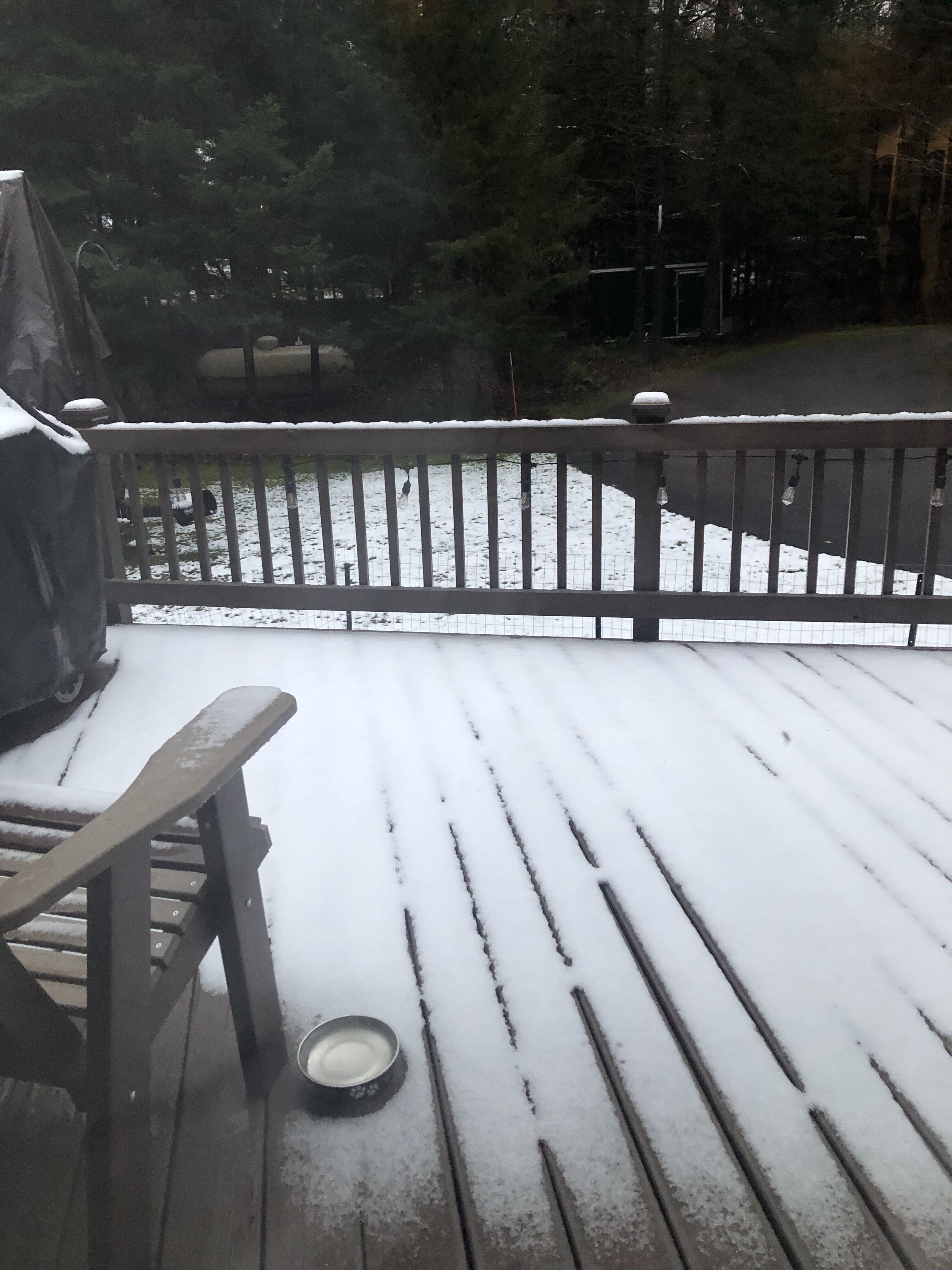
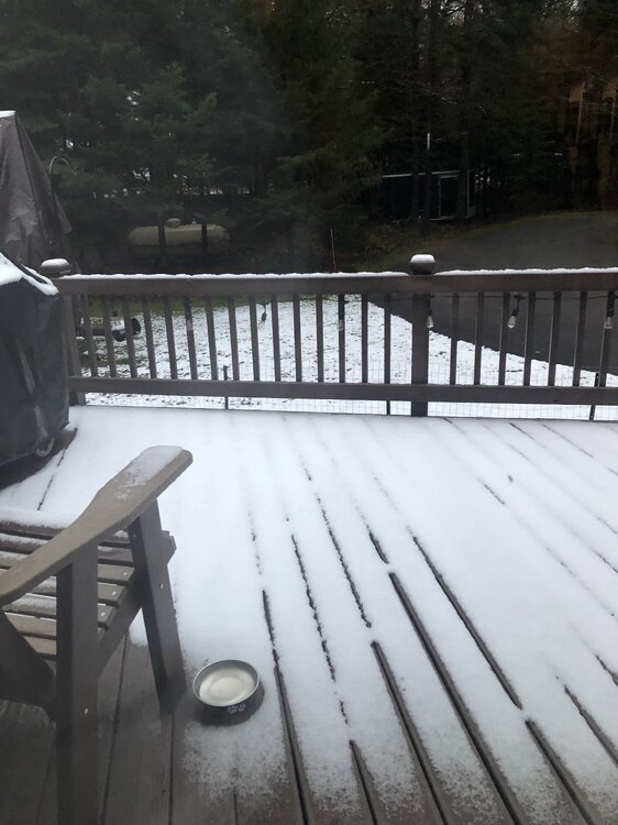
Added the monthly outlook update from Oct 31 to the topic. Canadian block gone now for at least a couple weeks so maybe the extreme potential down here is reduced til later Nov? Fast flow USA/Candian border suggesting frequent gusty CFP's next 10 days. Attached snowfall in Old Forge NY this Nov 1 morning, just to whet your CP appetite. I hope we get more than a half inch this winter in the park.
-
ALL OKX climate OCT sites above normal except CP min about 0.3". Recovered much of the monthly rainfall in 24 hours.
-
Much more extensive and longer lasting than anticipated here in NYS/nw NJ... had a 3.75 hr outage at 210A today.
-
Intensity skews the Ambient too high... Light rain usually very close but when it gets intense, the automated gage runs too high. At least it rained
- 246 replies
-
- 2
-
-
- heavy rain
- damaging wind? squalls?
- (and 2 more)
-
Yes criteria gusts at many of the ASOS's 40-43 kt as of 3PM ish. Conversion factors on the 06z models except ECMWF were too weak. Multi NWS office Wind Advisory verifies! Power outages today, almost twice that of yesterday-see below. We've had a brief outage in Wantage NJ. Most of the branches I've seen down in Sussex County from Wantage, Andover-Hopatcong are the 1-2" dead ones but one larger in Hopatcong was being removed around 130PM. Outages by StateOutages by Utility New Jersey20,356 New York18,472 Pennsylvania17,100
-
Branches down SC NJ
-
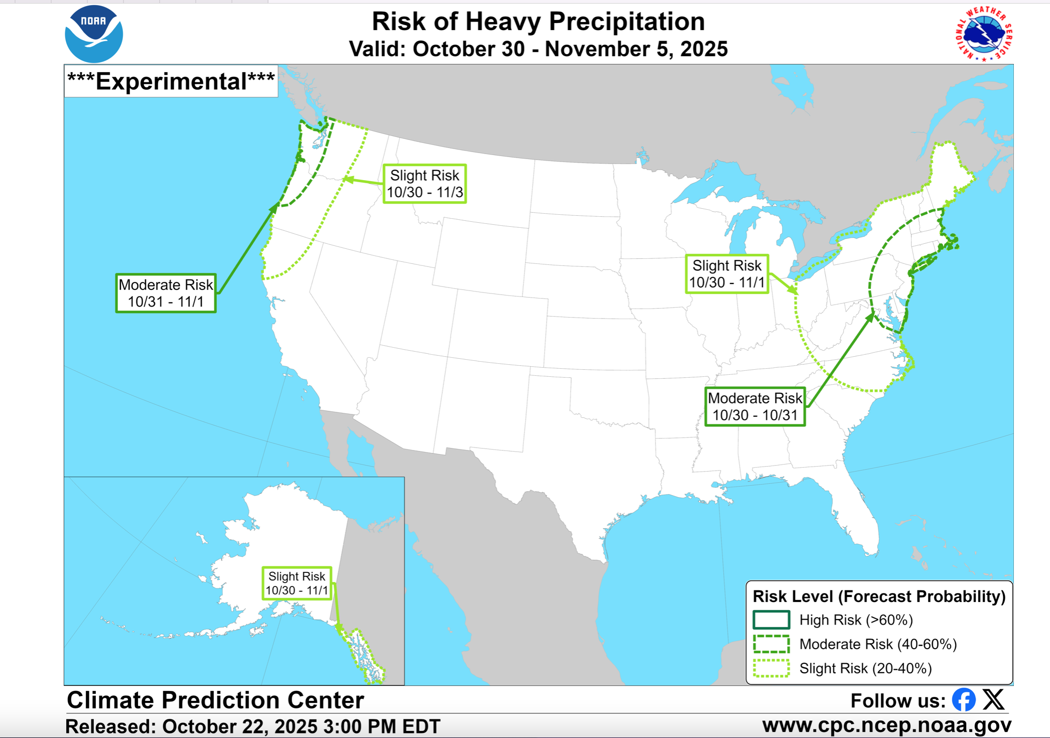
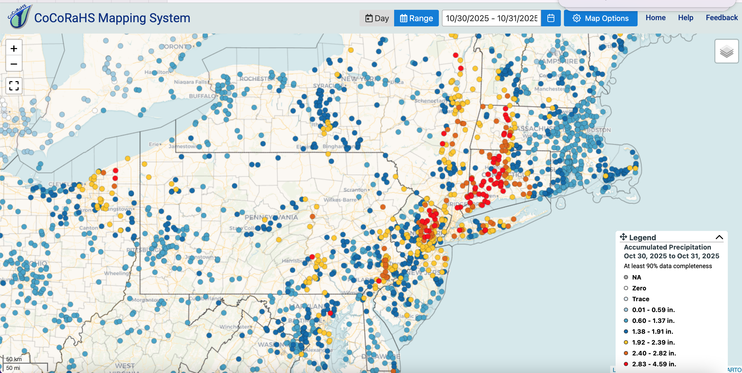
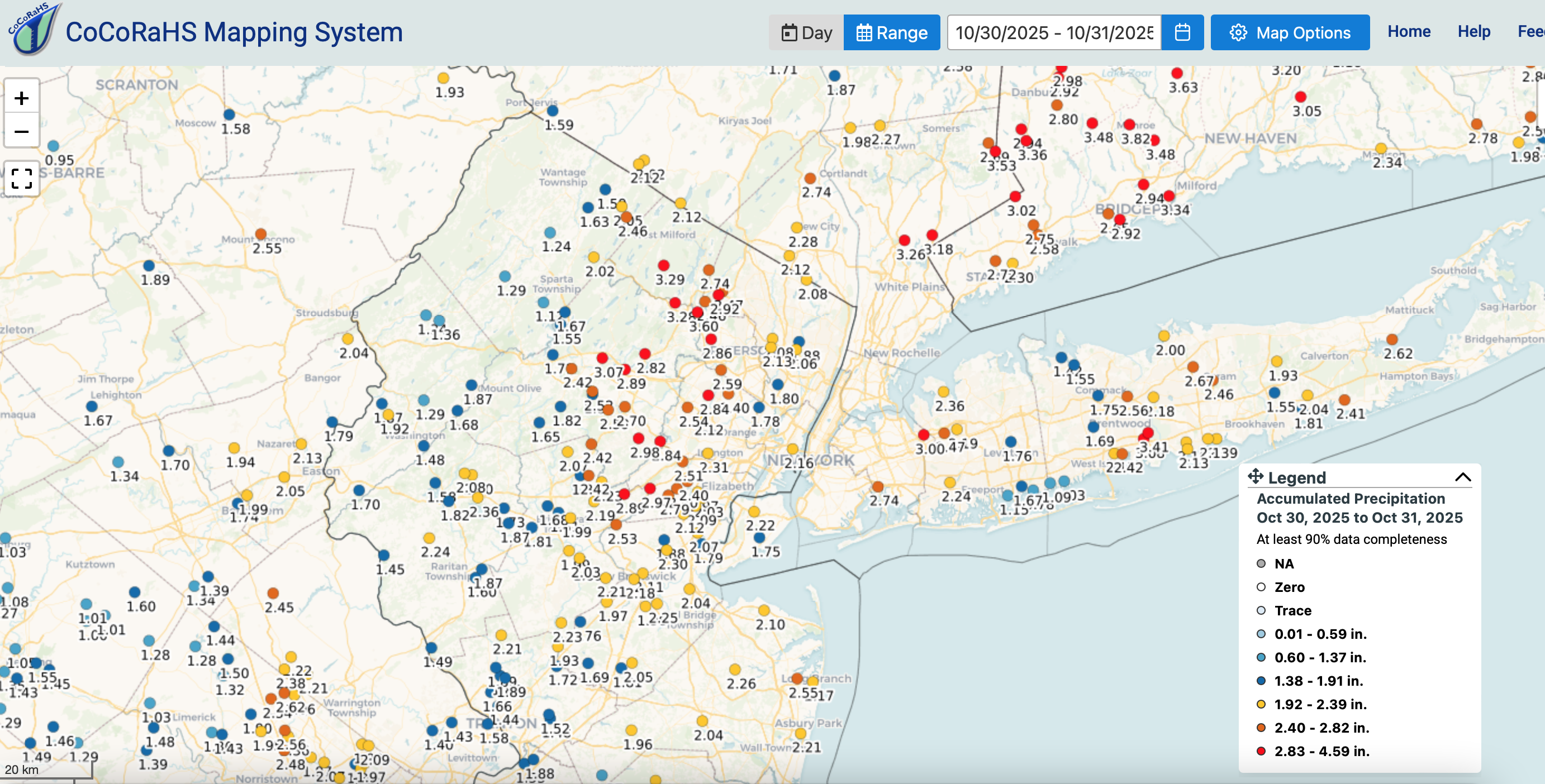
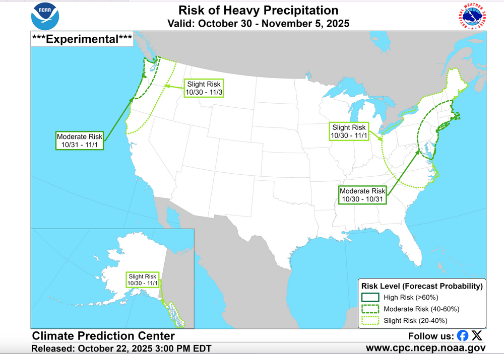
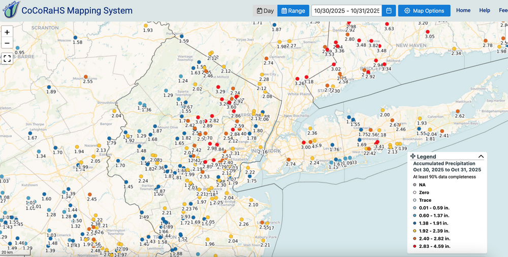
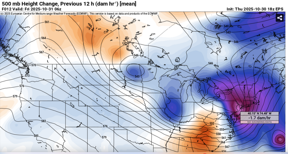
Summary message: I could not go back to review the OHP between 16z-20z/30 for the unfortunate fatalities related to only very short fuse prediction of 1" in 15 minutes over NYC... results as cellar fatalities, again, as in prior city FF. That's the part that didnt work out in the thread. Otherwise see graphics below 1) CPC D8 1"+ heavy rain forecast (MDT risk) 2) CoCoRaHs region red and orange dot verification of the main axis of heavy rain (see legend) 3) NYC subforum rainfall 4) EPS 06z/31 5H... note negative tilt lobe to NJ 5) EPS 18z/30 12 hr 170M HFC over NJ... large 12 hr HFC's need to be contended with as event concerns...given adequate moisture. You can use these graphics to go back to p1 of this thread to verify the Sunday 10/26 post. Modeling was helpful for sure. GEFS rainfall and max gusts were terrible as compared to the EPS and EPSAI modeling.


- 246 replies
-
- 3
-
-
-
- heavy rain
- damaging wind? squalls?
- (and 2 more)