wdrag
-
Posts
5,603 -
Joined
-
Last visited
Content Type
Profiles
Blogs
Forums
American Weather
Media Demo
Store
Gallery
Everything posted by wdrag
-
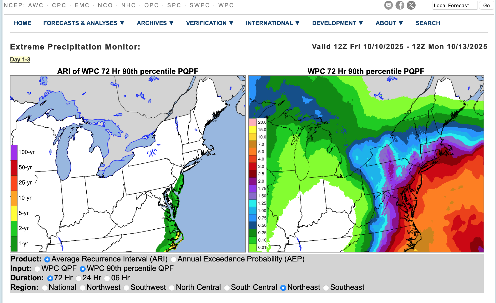
fwiw: Average Return Interval on the 10z/10 WPC 72 hour FCST qpf... NJ coast every 1-2 years.

-
All the watches and alerts were posted by NWS yesterday afternoon (9th/20z). Not changing this headline. Am not thinking any different-likely not worse than posted. Will adjust this as an OBS thread tomorrow. BUT... if anything, am not seeing the kind of phaser that was implied approaching thread post time (740PM Wed eve). Ensembling suggests the Great Lakes closed low short wave is tracking a little too far northeast to completely phase with the southern trough... instead a weaker wet windy scenario with impacts but certainly no greater than the thread headline. There is still time for the worst case coastal hugger scenario but am thinking that this won't be quite as alarming... welcomed rain, a few power outages and certainly moderate coastal flooding for 1 to possibly 3 high tide cycles. While major is still possible, I think less chance of major than what I saw 2 days ago. Again... still a problem for the involved coastal communities. On tidal predictions: when you look at the various model predictions, the GEFS suite is worst, and associated with the more closer coastal hugger scenario. I now have to consider the NAM/EPS/ECAI scenarios of a little further east (00z/10 cycle trends) On tides: am not sure why a few folks are saying astronomically large departures---NOT TRUE. We're out of the full moon phase. Someone please clarify. So, a decent storm but unless modeling changes... am not changing headline as written and presuming everyone has enough information to plan/avoid/mitigate the coming adverse impacts. Will recheck late today...
- 731 replies
-
- 5
-

-

-
- heavy rain
- damaging wind
- (and 2 more)
-
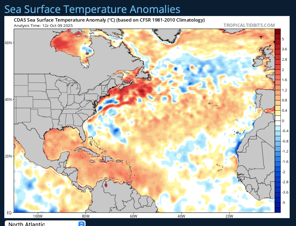
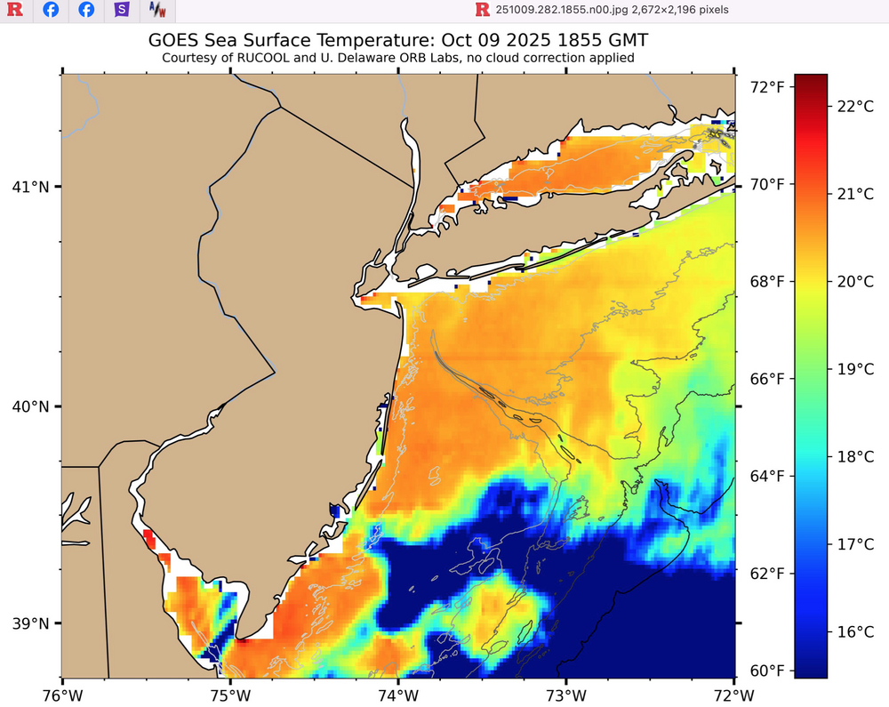
Following up on your post: I took a look at SST anomaly at 12z/9 this morning. VERY warm departures and water temps right now SDHook, Entrance to NY Harbor around 68. I think we're talking fairly steep lapse rates in the BL Sunday-Monday permitting pretty decent downward transfer of gusts. Two graphics attached. Surface temps should be in the range of 57-63F on the NJ coast and probably LI north shore as well 18z Sun-18z Mon. That is cooler than the SST. Using 12z EC OP model sounding - I see what appears to me a fairly unstable lowest 50 MB. That is only the 12z/9 EC OP. (did not attach the sounding-its predictive and still 72-96 hours distant). We'll see how intense the wind fields evolve etc but needs to be monitored for watch/warn process and resultant water and power outage situation on the coasts. No coastal hugger, much less impact.

- 731 replies
-
- 3
-
-
- heavy rain
- damaging wind
- (and 2 more)
-
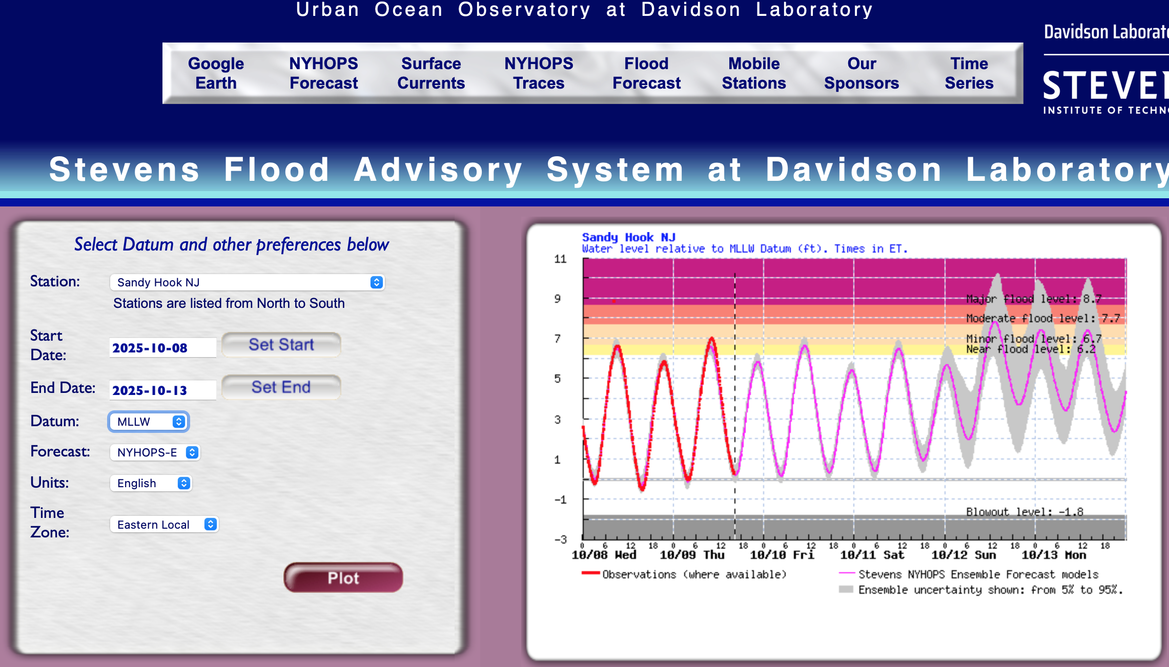
Still MUCH time for adjustments. The ensembles are all damped out out with variable solutions so believing an op cycle straightforward is not recommended. The EC OP is in the high end impact group with almost an eye circulation off Cape May come late Monday but for now, in the back of my mind but not barking it as the more likely solution. Someone mentioned the deformation zone as a potential area of concern for surprise high amounts. I am in agreement. Therefore am thinking along and north of the eventual 8H-7H circulation will be large, which eventually favors much of our area, especially NNJ-LI and not a big trim in s CT. Evolution uncertainty. Not upgrading to spot 6" amount in NNJ (Ocean County northwestward) but monitoring circulation development and staying as initially posted last several days and in this thread last evening. LONG ways away. Added 12z/9 NYHOPS tidal expectation at Sandy Hook as an example. The outlier is MAJOR. the more likely scenario at this 3-4 day juncture is MDT for at least one cycle at Sandy Hook, as exampled. Recent water level bias has been a couple inches one the low side of reality, from what I can tell. Checking back later this evening or tomorrow morning.

- 731 replies
-
- 3
-
-
- heavy rain
- damaging wind
- (and 2 more)
-
So far, outlooks for the season seem to be heavily biased on the negative side... as some will say, underperforming, for US hits. Still time of course.
-
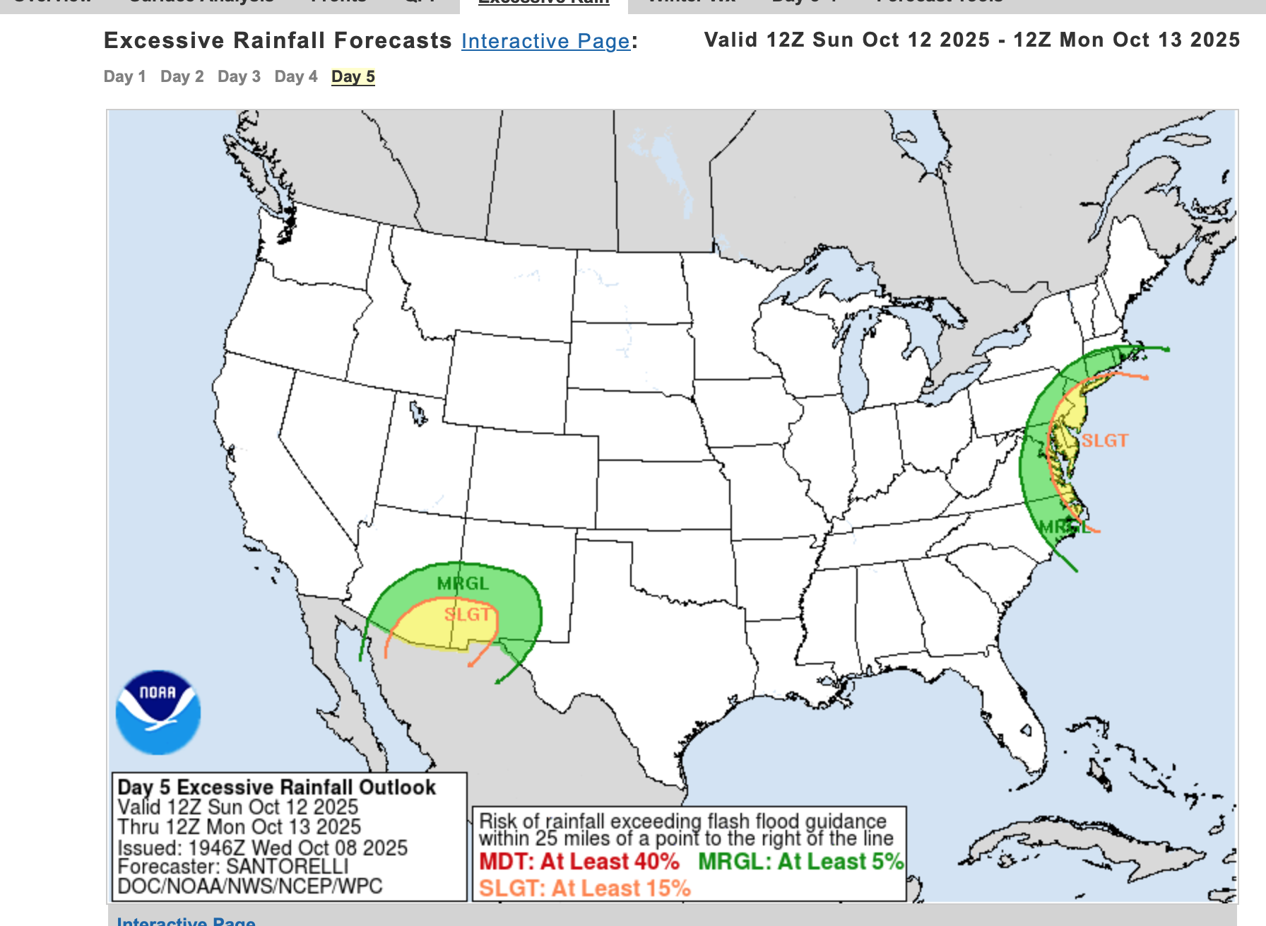
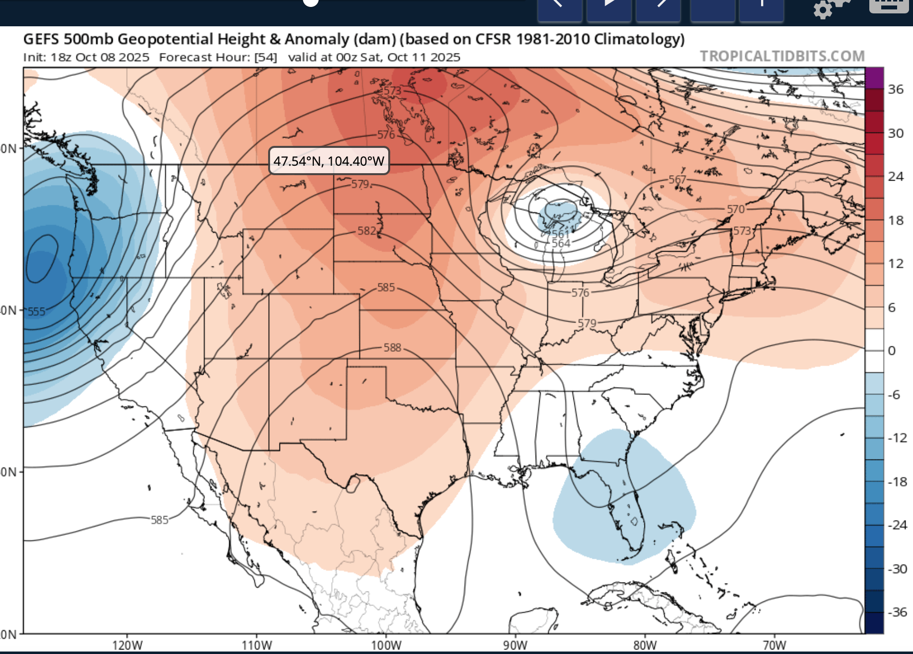
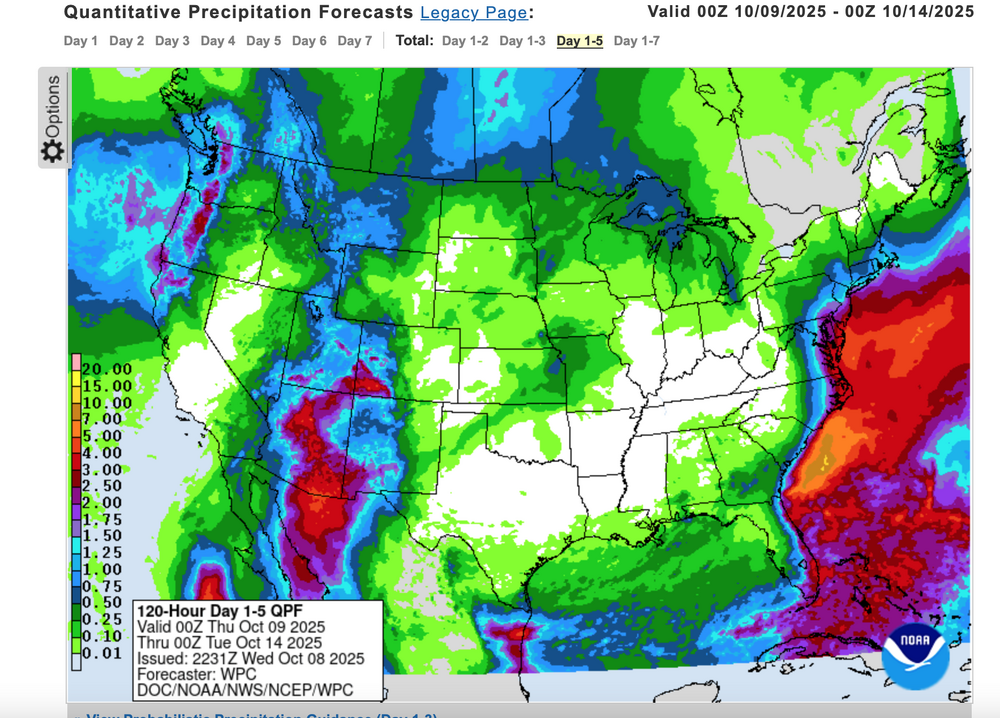
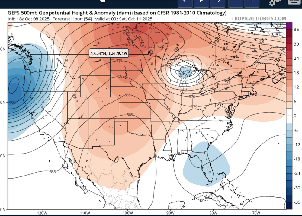
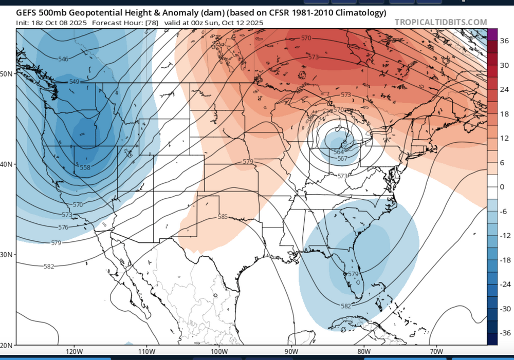
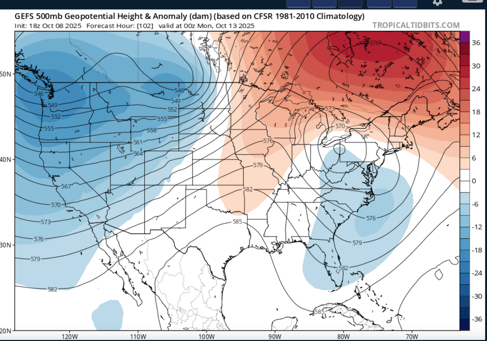
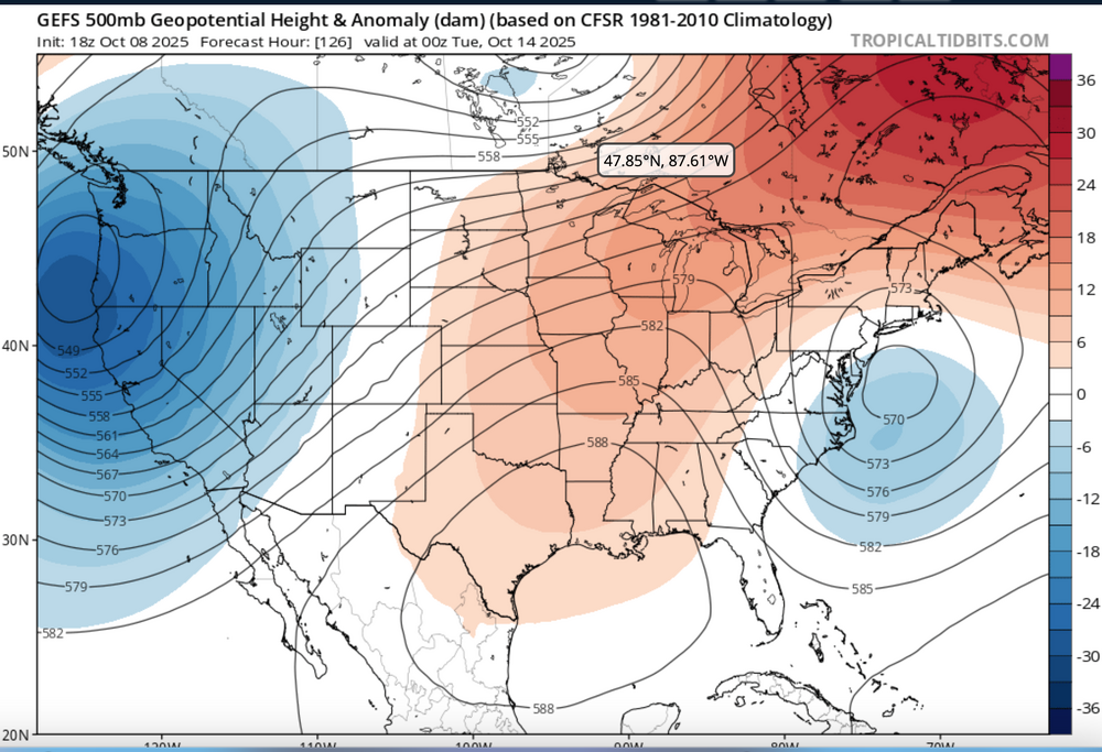
Nor'easter coming Sunday-Monday though track uncertain ranging from coastal hugger e of NJ worst case scenario to further southeast and less impact. Graphics added are the Wednesday afternoon's WPC 5 day rainfall forecast ending 00z Tue 10/14, The WPC D5 concerns for excessive rainfall issued this Wednesday afternoon - Isolated 4" in the slight risk area but general 1-2" foreseen for much of the NYC subforum between 6AM EDT Sunday and 6AM Tuesday. Also added 4 successive 24 hr forecasts of the evolving 18z/8 GEFS 5H field which I hope repeats this winter... a phaser with a southeastward diving cold core strong short wave through the Great Lakes this weekend that ingests-draws northward - the moist trough currently developing along the se USA coast and results in a fairly intense storm along the mid Atlantic coast by Sunday. The EC EPS 24 hr max wind gust tool has been cyclically consistently offering 60+ MPH in the western Atlantic and 50+ MPH along parts of the NJ-LI coasts. If this occurs, in conjunction with heavy rainfall, fully leaved tree branches would break or even uproot in some locations. No guarantees on wind strength at this time The strong chilly high pressure system that is developing into our area now will become part of a eastern Canada block and set up a strong easterly gradient over our area and should result in multiple cycles of at least minor coastal flooding with a pretty strong potential for at least one high tide cycle moderate coastal flooding (even outlier LOW PROB spotty major) for either the midday Sunday or midday Monday high tide cycle along the NJ coast. Full moon is past us so the astronomical higher tide cycles are lowering and helps reduce the chance of more than moderate coastal flooding. Still this is 4-5 days away, so intensity, track and system evolution are not locked into a worst case scenario and will ultimately determine impacts. Erosion will occur...severity unknown. It appears the ECAI has been most cyclically stable predicting this storm for our NYC subforum dating back to I think the 00z/4 cycle. Did not look at standard deviations departures of the 850 MB inflow but suffice to say, its stronger that normal. PWAT generally near 1.5" minimizes potential for much greater than 4" though the 2" PWAT axis lies just offshore. Thread headline Original thread headline below, adjusted 422 PM Saturday 10/11 "Potentially" powerful Nor'easter Sun-Mon 10/12-13/25 with needed rain-especially south of I84, and fairly high impact sct coastal gusts 50+ MPH and possibly moderate or greater coastal flooding at the midday Sun and Monday high tide cycles. posted 741PM/8

- 731 replies
-
- 9
-
-
-
- heavy rain
- damaging wind
- (and 2 more)
-
Yes... I want to do some outside work while still daylight but all ensembles now on board, despite the 12z/8 CMCE OP OTS. widespread wind driven 1", iso MAX 4 12z Sun-12z Tue G 50-60 Mph LI NJ coasts, beach erosion, multiple cycles of at least MINOR CF, with potential for major NJ coast Sun and Mon highest tide cycles. Probably start it around 8P.
-
SUBTROPICAL low for the e coast this week-early next week? Will this get some sort of NWS identity in the very near future if modeling continues on course (GFS/EC). ? This is where NWS-NHC step in. I accept their definition. It is tropical moisture late this week unleashed by a developing cold core aloft (7h-5h as example this weekend) and the cold air bordering the system to the west and north. . I've been out of NWS since 2018 but this might get an identity of some sort. Little question in my mind regarding potential high impact along the coasts for LI-NJ southward and maybe across to the SNE coast? I just want ECAI which has been consistent cyclically for an event since the 06z/4 cycle (see trop tidbits for `12z Monday Oct 13)
-
.44 here in Wantage midnight-6A.
-
This is where NWS-NHC step in. I accept their definition. It is tropical moisture late this week unleashed by a developing cold core aloft (7h-5h as example this weekend) and the cold air bordering the system to the west and north. NWS OKX (or elsewhere) step in. I've been out of NWS since 2018 but this might get an identity of some sort. Little question in my mind regarding potential high impact along the coasts for LI-NJ southward and maybe across to the SNE coast? I just want ECAI which has been consistent cyclically for an event since the 06z/4 cycle (see trop tidbits for `12z Monday Oct 13)
-
Just waiting on 06z EPS/EPSAI... looks good, in large part due to shortwave diving se through the Great Lakes late this week forcing a closed low there, then ingesting the separate southeastern USA 5H trough-rain area. Doesnt look like a tropical system to me but a pretty strong nor'easter Noon Sunday-Noon Tuesday. 1-4" NJ/LI w G 50-60 MPH, power outages from fully leaved tree branches breaking, and coastal flooding Sun-Mon high tide, with potential for one of these midday high tide cycles MDT coastal flooding (low prob spot Major). Less impacts CT/NYS but still beneficial. Canadian is a no show so far and I do want to see EC AI become bigger again. Still a chance the brunt escapes s NJ-Delmarva.
-
Dont think this will miss but will wait til the 06z/8 cycles are in tomorrow morning to start a thread for 1-4" of rain NJ/LI and less north with G 50-60 MPH coast Monday. ECAI I think will go back solid hit by tomorrow morning. If it does not, then will leave this as a general 0.1-1.5" rain and no thread. I think a clue to further N is the 12z/7 GEFS showing the closed 5H low starting in the Great Lakes Sat night and then it may become the dominant driver instead of further S. Something I'm watching but not yet completely sold. I'm prepared for periods of rain here in nw NJ 18z Sun-18z Tue...something like that. gotta run and cut the summer cone flowers.
-
12z/5 ECAI looks like the outlier now as 12z-18z/5 global trend is south or nil for Sun-Tue. If this ends up nil, it would undermine my confidence in the still consistent soaking EC AI. Waiting it out a day or so.
-
Back from a week in the PAC NW (SEA-SFO). Seeing cyclic consistency in the EC-AI op strong nor'easter hit since 00z/5 (6 consecutive cycles). EPS EPS AI gaining confidence (50-60 MPH gusts potential coastal spots s LI and NJ, as well as 1-4" rain). BUT as noted previously by others, a little early to be sure though WPC D7 QPF has accepted the likelihood of a significant storm. BOM has not. Also duration of event is in doubt from a decent 18 hr hit to a lengthy 60 hour event. Too soon for a thread but many are monitoring. Have a day and will recheck tomorrow morning.
-
September 2025 OBS-Discussion centered NYC subforum
wdrag replied to wdrag's topic in New York City Metro
Saw the much less than modeled rainfall totals for this past week. Maybe we get more tonight and tomorrow which was in the original consideration. Still a bit dissatisfying totals -
Any TC rain hits? Any early season interior high terrain snow acc late in the month? Do we experience above normal rainfall for October?
-
September 2025 OBS-Discussion centered NYC subforum
wdrag replied to wdrag's topic in New York City Metro
I didnt start a thread... bit marginal for iso 5" by 12z Friday but certainly a general 1-3" event coming with uncertainty on best axis 5. Someone will probably get into an iso FF situation- water rescues etc but its not widespread enough for me to thread. Of continuing interest for me is additional rainfall Friday-Sunday morning per closed low connection to our south. If that happens... we could be blessed with another 0.1-1.5" N to S. across our subforum. It seems to me the front will hang up closer to us than now modeled. -
September 2025 OBS-Discussion centered NYC subforum
wdrag replied to wdrag's topic in New York City Metro
Continuing review for a possible thread 6PM today for 22z/24-12z/26.Pprior posts by Bluewave have it right. 1-3 iso 5 possible. Getting complex. The closed low OH Valley will happen and looking like we get something addition from it 18z Sat-18z Sun. Thereafter, uncertainty greater but as noted previously, tropics get involved with the east coast trough-W Atcl ridge. At a minimum, I would not be fishing in the coastal waters next Tue-Wed. Even if the tropics peel east-shunted s, the large cool high settling into New England sets up the potential for an early season modest gale on the CW s of LI and e of NJ, assisted by the larger BL temp lapse rate. Offline most of the day. 0.24 here in this part of nw NJ last evening. -
September 2025 OBS-Discussion centered NYC subforum
wdrag replied to wdrag's topic in New York City Metro
for now-no thread on the oncoming early Tuesday morning WPC D1-3 1-3" and SPC D1 and D3 marginal svr. Anything after Friday morning is in doubt. Think it best to happen in the 60 hr window 18z today-06z Fri. -
September 2025 OBS-Discussion centered NYC subforum
wdrag replied to wdrag's topic in New York City Metro
Glad it worked out despite off by 4 miles on storms... and much thanks for the followup review (including dance)! -
September 2025 OBS-Discussion centered NYC subforum
wdrag replied to wdrag's topic in New York City Metro
No thread attm--maybe something delayed now til late Tuesday???: need more ensemble support but still looking at widespread 1-3 rainfall totals Tuesday afternoon-next Sunday with iso 5+ POSSIBLE. Depends on evolution and track of developing UA low Ohio Valley middle and end of next week... ie stall the showery late Tuesday surface CFP just to our south Wed-Sunday with weak waves of low pressure. LONG Ways off but am not too alarmed by the recent dryness... happens and then a blast of rain. We do need that OH Valley Upper Level (5H for example) LOW to form and eject across NJ next Sunday as it finally weakens. Otherwise wait til October. All ensembles 1+. My greatest doubt is Fri-Sun...whether the tilt to the trough is more positive than what I thought yesterday, not permitting the Fri-Sun portion of the qpf into our area but shunting it further south across the Delmarva?? Yes, am aware that this OH Valley trough and eventual eastward progress might build the w ATLC ridge enough to permit a tropical threat late Sun-next Tuesday=this paragraph said with little confidence but awareness. For now... lets get some beneficial rain in here Tue-Thu. I haven't checked on the svr threat. Have a day. -
September 2025 OBS-Discussion centered NYC subforum
wdrag replied to wdrag's topic in New York City Metro
No thread attm--maybe something late Monday???: need more ensemble support but looking at widespread 1-3 rainfall totals Tuesday afternoon-next Sunday with iso 5+ POSSIBLE. Depends on evolution and track of developing UA low Ohio Valley middle and end of next week... ie stall the showery late Tuesday surface CFP just to our south Wed-Sunday with weak waves of low pressure. LONG Ways off but am not too alarmed by the recent dryness... happens and then a blast of rain. We do need that OH Valley LOW to form and eject across NJ next Sunday as it finally weakens. Otherwise wait til October. -
September 2025 OBS-Discussion centered NYC subforum
wdrag replied to wdrag's topic in New York City Metro
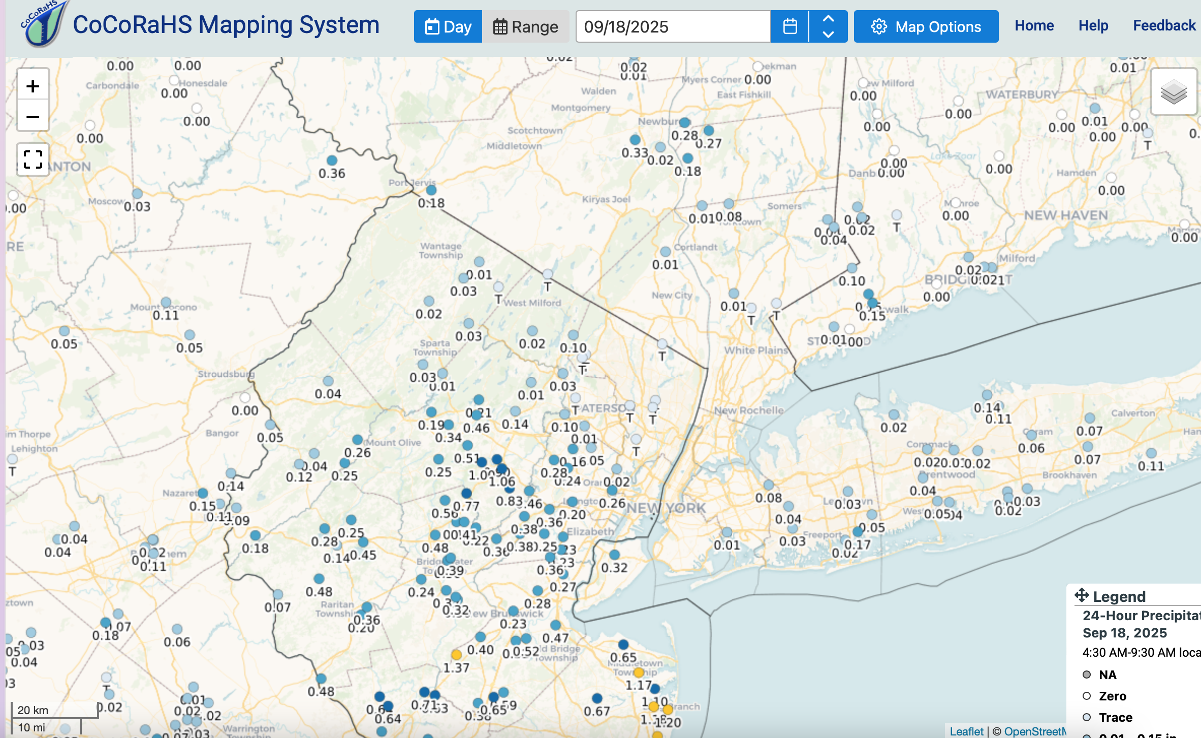
CoCoRaHs after 6A 9/17/25. Isolated near 2" Wall Township in Monmouth.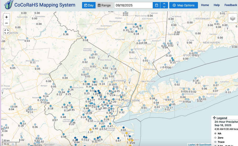
-
September 2025 OBS-Discussion centered NYC subforum
wdrag replied to wdrag's topic in New York City Metro
Wantage NJ this part. about 0.10. (NOT zero). -
September 2025 OBS-Discussion centered NYC subforum
wdrag replied to wdrag's topic in New York City Metro
Around 3/4” now in parts of Monmouth County past 6 hours and spotty hourly amounts, Over 1/4”. Finally got going.