wdrag
-
Posts
5,603 -
Joined
-
Last visited
Content Type
Profiles
Blogs
Forums
American Weather
Media Demo
Store
Gallery
Everything posted by wdrag
-
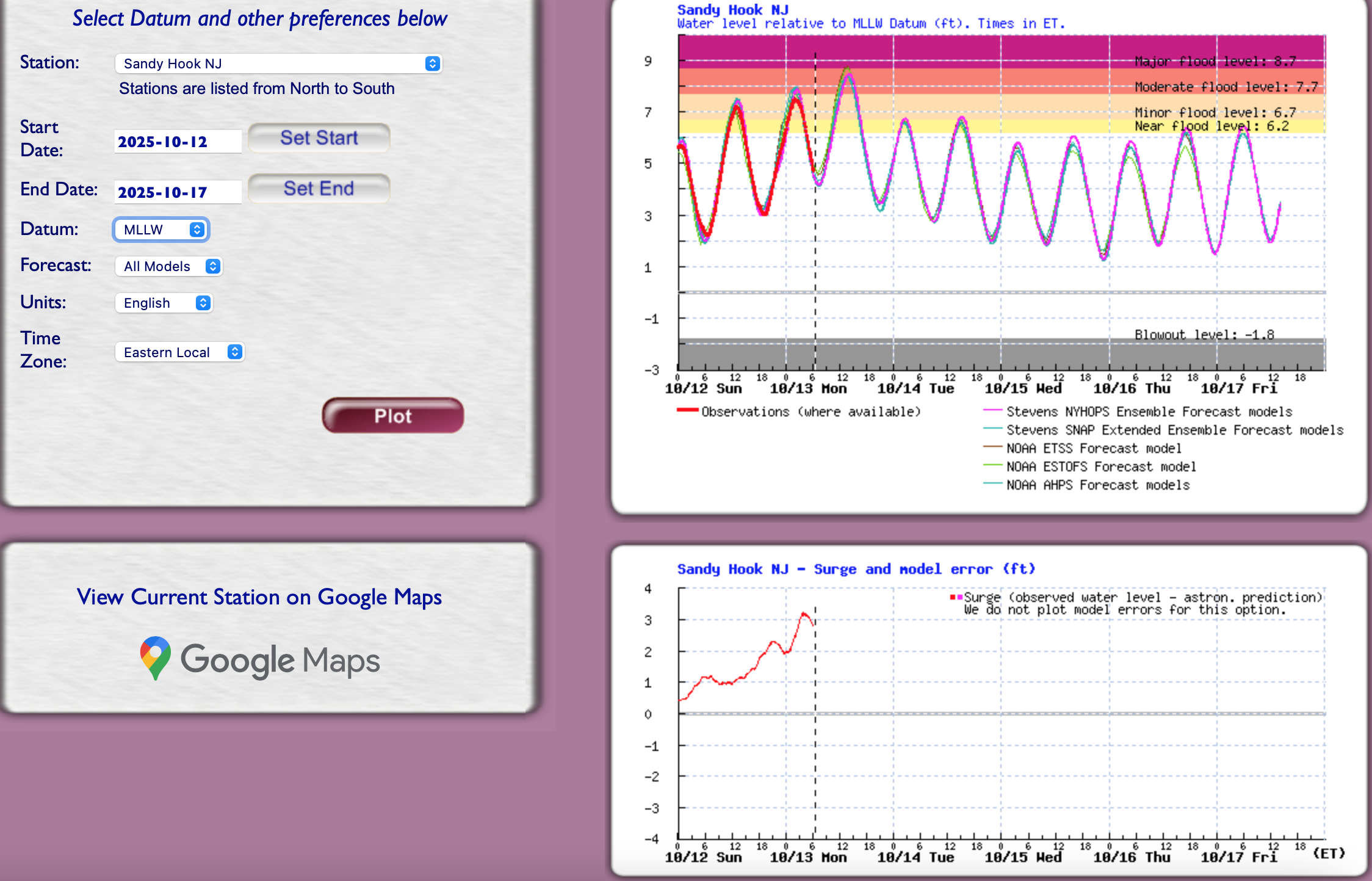
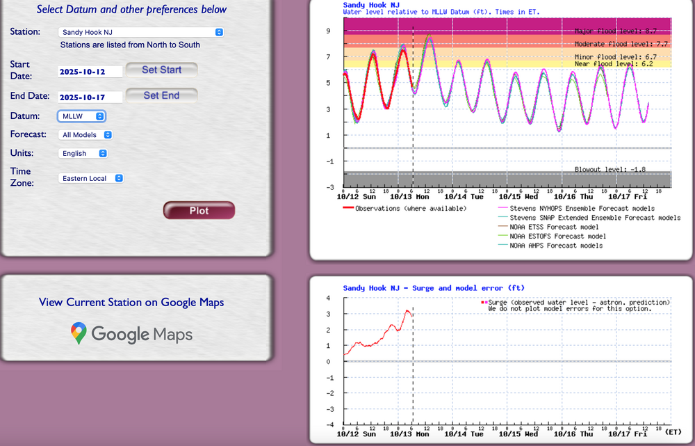
We'll await the official readings but at Sandy Hook... I think the max came in near 7.8 MLLW or on the cusp of minor-moderate CF threshold... statistically.
-
8.92,at 1242pm ish is a 6 min spike of a foot and unrealistic. until NWS blesses it, I’d rely on the smooth tidal curve
-
I don’t think so. Follow NWS. Thanks. Lost power for 75 min At 11. Catching up
- 731 replies
-
- 1
-

-
- heavy rain
- damaging wind
- (and 2 more)
-
Tidal: am virtually certain moderate CF develops at Sandy Hook area midday... long duration of minor tidal inundation. Tides still running 3' above predicted at 940A. Should make about 8' MLLW there. Not sure what OKX has but follow what ever they have including the datums they select.
- 731 replies
-
- 1
-
-
- heavy rain
- damaging wind
- (and 2 more)
-
I believe... it'll all get ironed out tomorrow morning OKX PNS and official climate site data inclusive of CoCoRaHs. Enjoy the nasty chilly day.
- 731 replies
-
- 4
-
-
- heavy rain
- damaging wind
- (and 2 more)
-
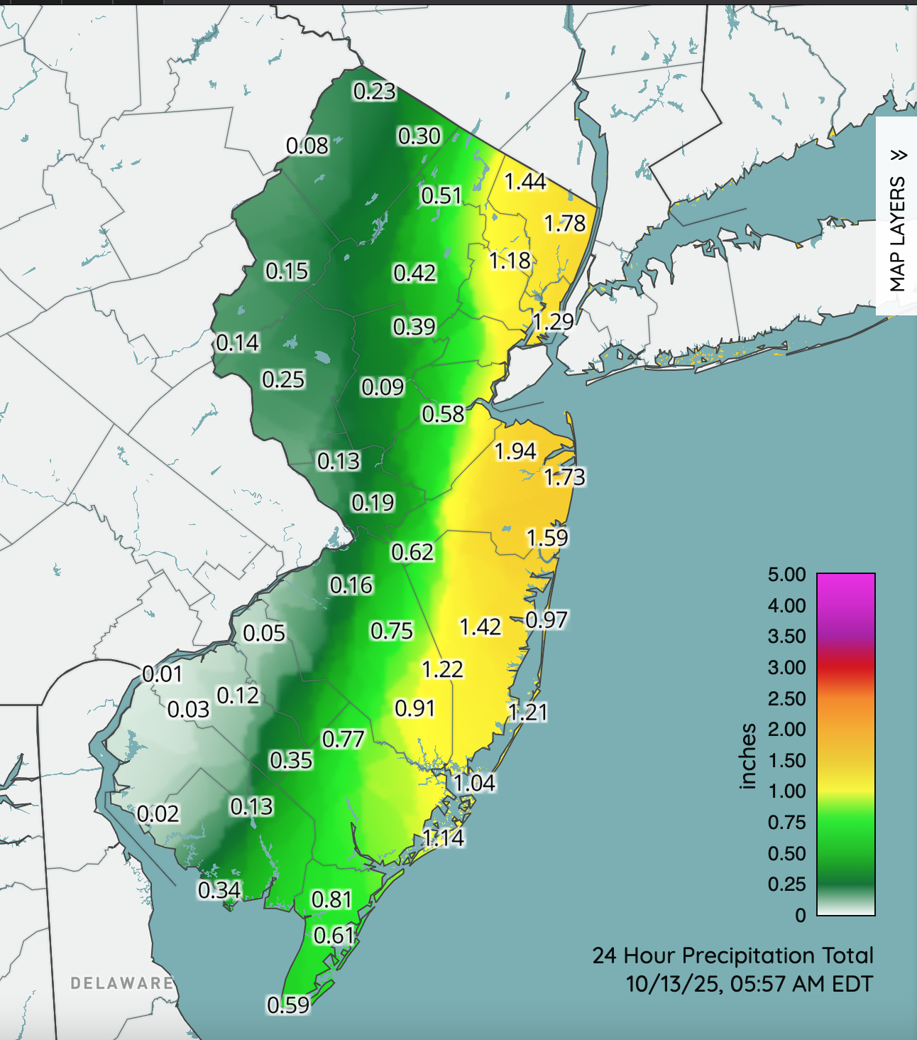
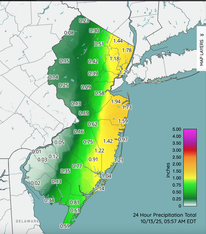
If this were winter...I'd say wait to crow until midnight tonight. MUCH more to come today. 1-2", iso heavier coasts and even interior will do ok. Convection developing per HRRR - might be quite a nasty afternoon parts of coasts. Am pretty sure some parts Li and eastern Nj will end up with 4". CoCoRaHs two day. .31 Wantage since 5P yesterday. Two day .4, heading for .6-1.0 three day totals by tomorrow morning. Click for more detail.
- 731 replies
-
- 2
-
-
- heavy rain
- damaging wind
- (and 2 more)
-
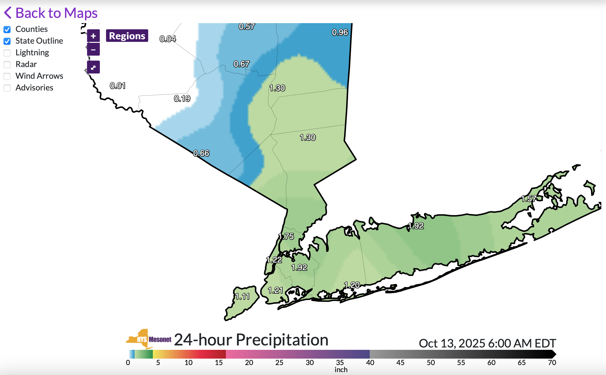
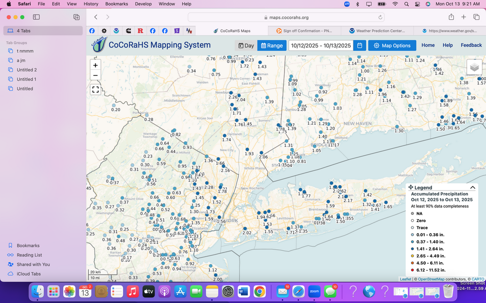
Officially past 2 inches for the entire event Sat-now at Holmdell NJ, Queens and Stony Brook on LI. Suggests to me that iso 4 within the realm of possibility. Otherwise bigger amounts of at least 4" will probably be coastal RI out to Cape Cod.
- 731 replies
-
- 1
-
-
- heavy rain
- damaging wind
- (and 2 more)
-
Isolated spots may be pick up an additional 2" between now and 8PM, along the coasts... IF convection emerges this afternoon as modeled by the HRRR. Looks like pretty good impact, travel wise per TV reports and what has been posted here this morning. Anticipate DELAYS and maybe some detours. Will post a summary report tomorrow morning around 9A, for CoCoRaHs 3 day totals but looking good. Wind driven rains this morning... intermittent in some spots.
- 731 replies
-
- 2
-
-
- heavy rain
- damaging wind
- (and 2 more)
-
Added the most likely scenario for the afternoon high tide, SANDY HOOK representing the onshore packed in water. Rainfall runoff and backed up streams that empty into the Atlantic will exacerbate the flooding this afternoon. So far, no official storm reports that I can see from OKX.
- 731 replies
-
- 3
-
-

-
- heavy rain
- damaging wind
- (and 2 more)
-
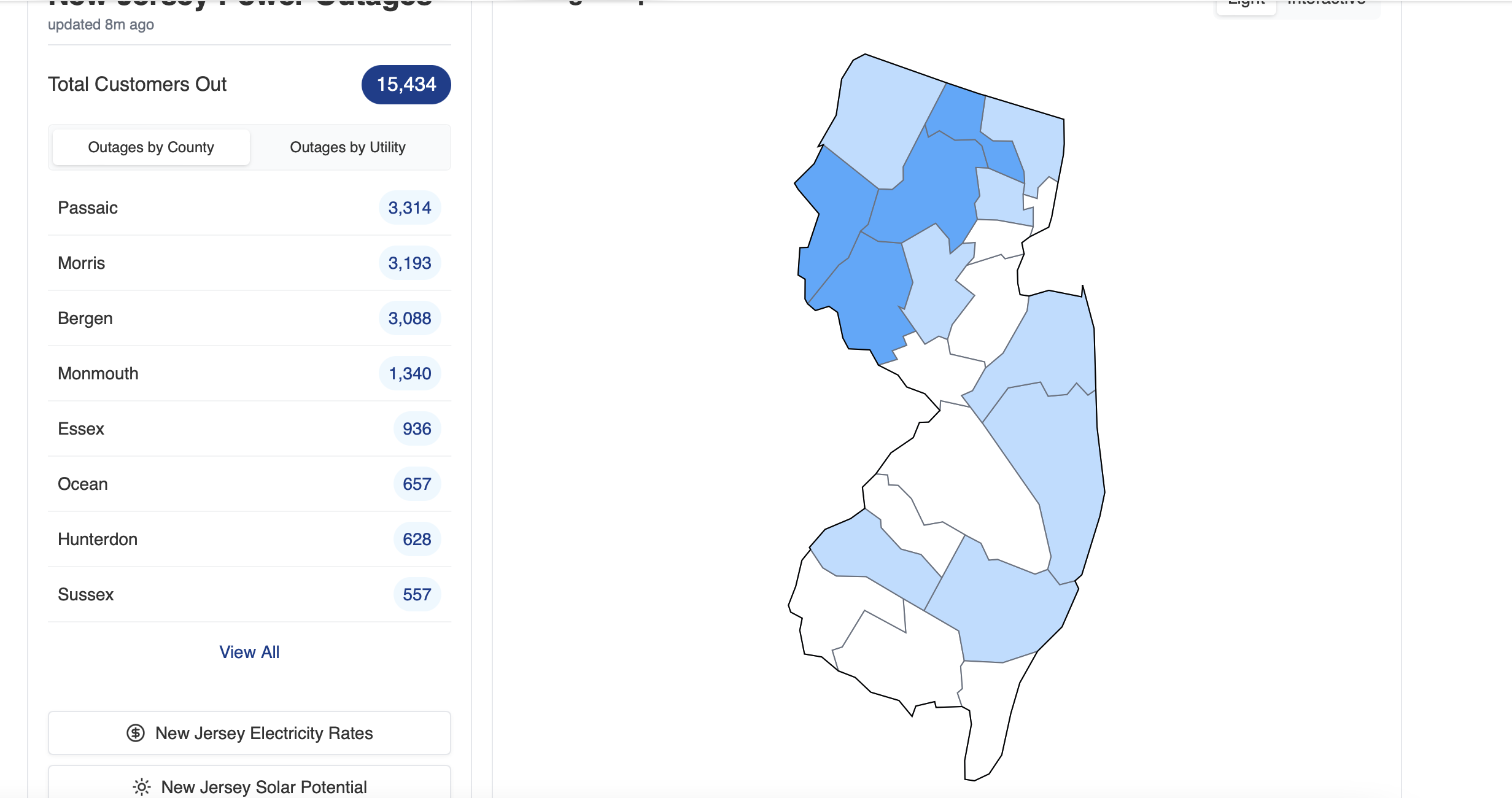
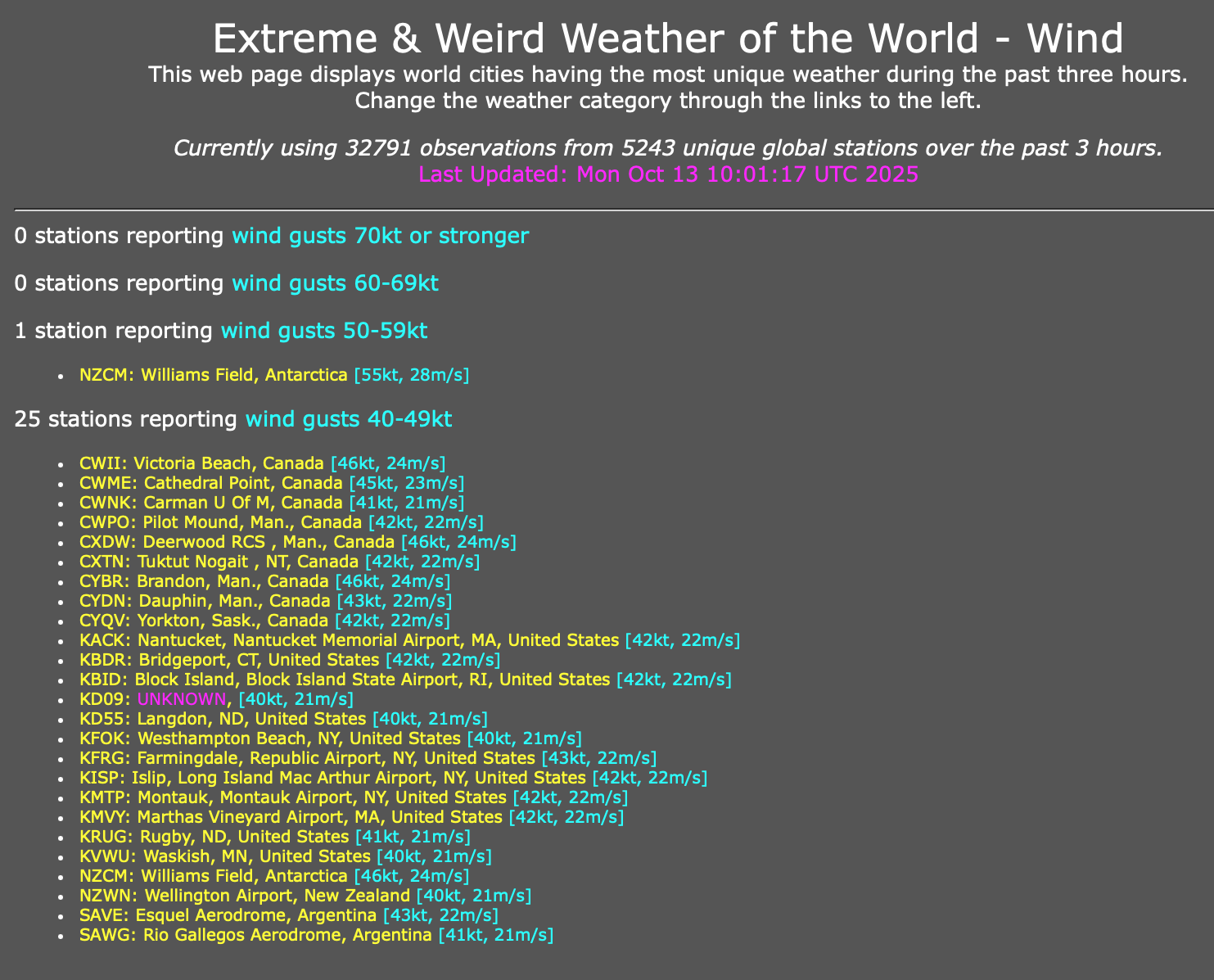
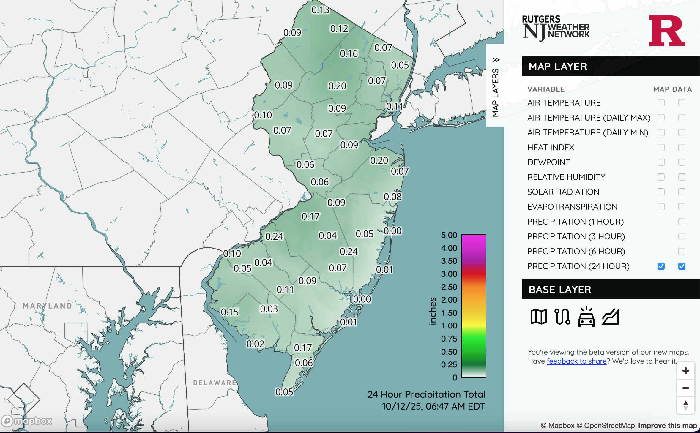
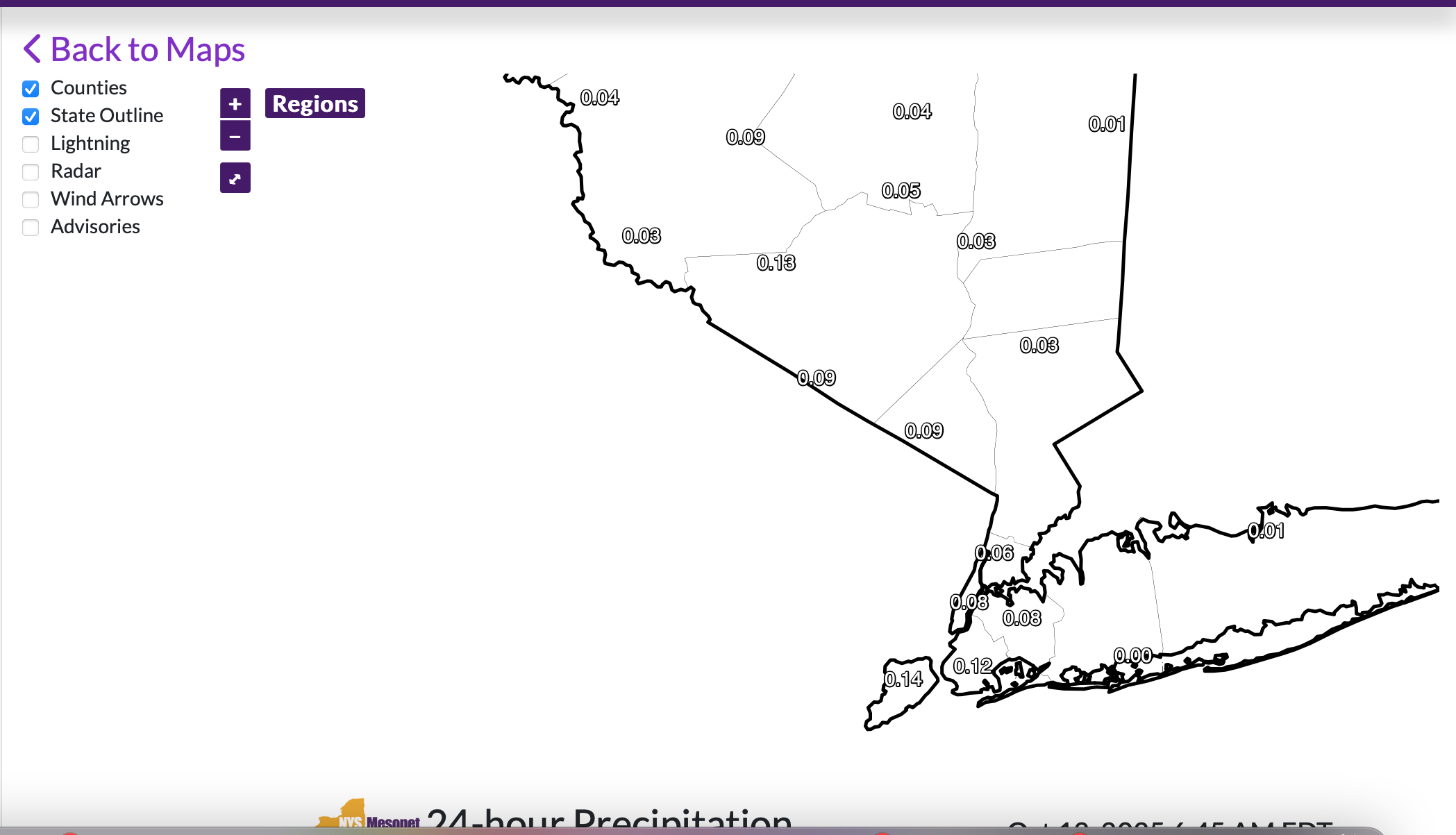
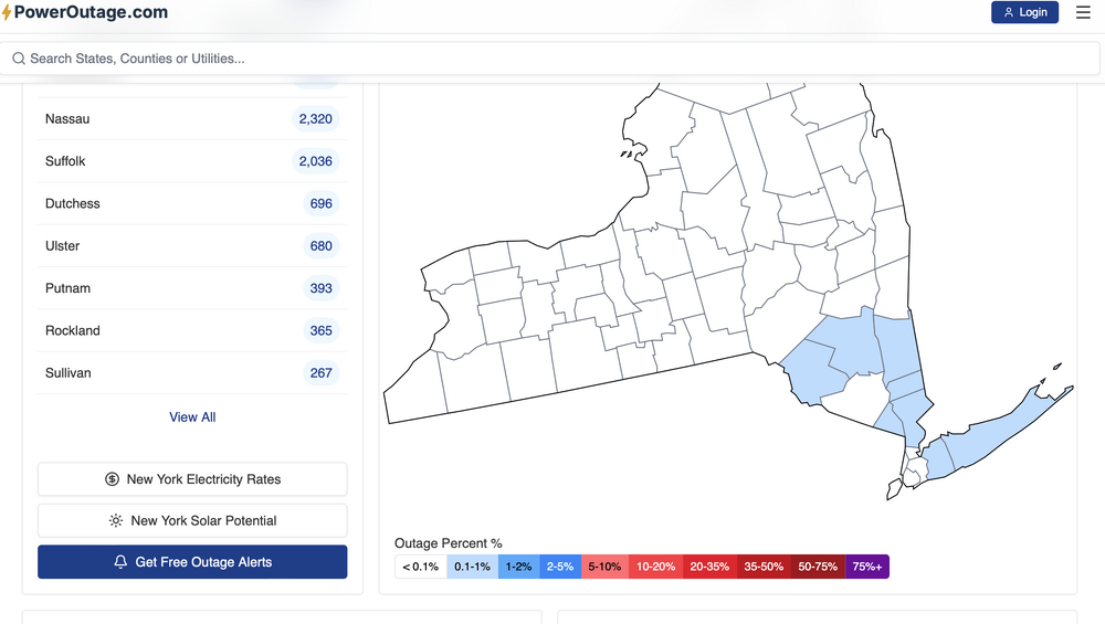
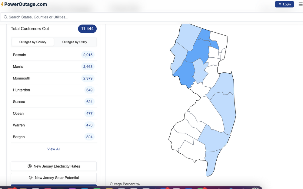
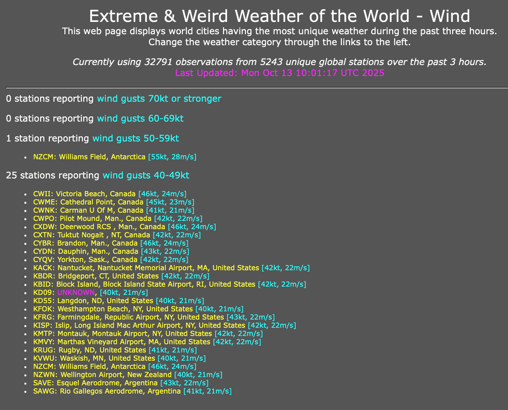
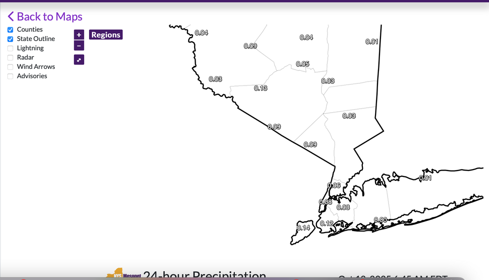
Visuals with power problems, even in nw NJ at 620AM Rides running 3' a move normal right now so a very good chance of moderate coastal flooding with the midday-afternoon high tide. Winds a little lower than expected on LI but the Fire MIN GUST tool from SPC HREF set the bottom line very well. So... here are some visuals on rainfall, power outages and airport gusts 46MPH or greater the past 3 hours ending around 6AM.


- 731 replies
-
- 9
-
-
-
- heavy rain
- damaging wind
- (and 2 more)
-
Wrong. You asked. Think it’s moving west now in NNJ
- 731 replies
-
- 3
-
-
- heavy rain
- damaging wind
- (and 2 more)
-
Cancelled Skylands Halloween Festival of Lights tonight... smart move. Think we may see iso 45 MPH early Monday. already has a few power outages in the county. Nothing major down the coast on power. Think the bigger PO will be up here LI and NJ coasts overnight.
- 731 replies
-
- 1
-
-
- heavy rain
- damaging wind
- (and 2 more)
-
Sometimes the straight laced Drag has to laugh. Good one.
- 731 replies
-
- 2
-

-
- heavy rain
- damaging wind
- (and 2 more)
-
Everywhere under the rain shield per OKX/DIX/JFK/EWR radars its raining with up to 0.2" past 3 hours in se NJ. mPing would break helpful next 36 hours.
- 731 replies
-
- 1
-
-
- heavy rain
- damaging wind
- (and 2 more)
-
fwiw: gust up to 50 MPH Little Egg Harbor NJ. 3" limbs reported broken at 1055A vicinity Orange NJ per mPing. Unsure of the mPing report Follow NWS... coastal situation appears on previous NWS track.
- 731 replies
-
- 1
-
-
- heavy rain
- damaging wind
- (and 2 more)
-
Follow NWS warnings and statements... am asking for no message confusion from the non government mets. A serious problem is developing for the NJ/LI coasts. In my retired state...hype sometimes is valuable and I think for our coastal residents, it's warranted for mitigating adverse impacts this afternoon through Monday night. No significant changes in the p1 outlook or thread title... if anything the thread title might be too conservative? Operationally: am not relying on the 00z/12 EC...too slow. I think 00z/12 ECAI look is much better. Tides seem to be running almost 2' above normal now. Winds are gusting to gale force along the NJ coast southward to the Carolinas. Rainfall for the past 24 hours is sampled by climate sites attached. I will try at times to monitor and post reality, but have a celebration of life service this afternoon, and two grandchildren 3-5 years old tonight-Columbus Day. You all have it... I think it best to keep NWS messaging similar. If you individually want to ignore... that is your ultimate responsibility. Try not to put first responders in jeopardy. Thanks. 707A/12

- 731 replies
-
- 11
-
-
-
- heavy rain
- damaging wind
- (and 2 more)
-
Thread headline 425 PM Sat 10/11/25 adjusted with little change in expectations-potential from the Wednesday evening origination. Will check back Sunday morning. Little more that I can contribute.
- 731 replies
-
- 7
-
-
-

-
- heavy rain
- damaging wind
- (and 2 more)
-
So far most of LI/se NYS and NJ .01 to .24" since 6AM ish.
- 731 replies
-
- 2
-
-
- heavy rain
- damaging wind
- (and 2 more)
-
Comments: Strength of storm not dependent on Lowest Pres but pressure gradient (MB between high and low at least 1kt/mb-my own rule of thumb) Not sure of the average return interval for an October northeast wind coastal wind event of G50 MPH? This looks to be a bit above average nor'easter in winter taking into account: qpf, coastal flood and wind gusts impact on travel. We shall see what wind and water do for any power outages... tomorrow night Monday morning? Unknown. If there is tree branch on your car... or in the road. MINIMUM gusts NJ coast and s Coast LI should be 40-45 MPH per 12z/11 SPC HREF. Suggestion is to stay with NWS messaging and not confuse the issue-mislead. Preparedness can be important.
- 731 replies
-
- 11
-
-
-
- heavy rain
- damaging wind
- (and 2 more)
-
Will update headline for OBS for NWS Warned fairly powerful Nor'easter etc around 5PM. Keep the info flowing. all good.
- 731 replies
-
- 1
-
-
- heavy rain
- damaging wind
- (and 2 more)
-
Follow NWS warnings and statements. Probably a good idea to plan altnerate travel plans Sunday afternoon-Monday night. Air travel will be impact as well roads. Deeper bands of heavier gusty rains Sunday night-Monday morning then low top steady light-briefly mdt rain Mon afternoon-night. I could be in error on my take but what am prepared for in the NYC subforum. Am not exactly sure what is out by NWS. I think they have the CFWRNG's out, if not...going to happen, probably 3 cycles of MDT, possibly a major in there Monday-also dependent on the sub basins, especially packing in on the northeast wind. Follow NWS. Coastal flooding also will have a river runoff component at the interface between incoming ocean waves, wind, elevated water level and dealing with 1-3" of rainfall runoff attempt into the ocean-marshes etc. My guess is that the HWA will convert to warnings on the coasts, for sct G50-60MPH, with the warning approach from my view, exacerbated by wet coastal ground, uproots and fully leaved wet leaves breaking branches Sunday evening-Monday. Could see few g45 MPH western NJ/se NYS and CT as well Sun night-Monday morning. Isolated inland flood warning in NJ (Ocean-Monmouth) Monday morning???? if some of the outlier model 4-6" materializes. Rainfall dependent. Modeling and WPC has consistently highlighted Ocean and Monmouth counties for biggest rainfall past few days. WPC trimmed qpf slightly in its early morning forecast. I'm expecting a little more than what they have, similar to early yesterday's 10z/10 forecast. Back later in the day. Will convert headline this afternoon to add OBS, but do add OBS rainfall from today when it occurs.
- 731 replies
-
- 4
-
-
-
- heavy rain
- damaging wind
- (and 2 more)
-
Good Saturday morning everyone, I've no change to thread headline. Too much guidance argues against softening the implied results. Once our most reliable global models say its gone, then I'll grudgingly accept... but am glad to wake up to a modeled decent nor'easter on the way. I've checked latest SREF/BOM/as well as all global ensembles that we often use and am not buying into the weaker eastward Canadian/ICON/UKMET ensembles...though they are within the realm of possibility. Even today... anyone noticing sprinkles out there on LI or the NJ coast now... see radar. It's going to rain later on today in NJ/EPA (iso 0.1-0.2)...not everywhere but this is the first part of the instability burst aloft as PW increases, drawn northward by the sewd moving Great Lakes closed LOW at 5H/7H. Eventually we get a break tonight or tomorrow morning, then the real deal begins Sunday afternoon with max impact risk, I think Monday. Everything stated on p1 of this thread continues. Modeling wavers but overall... beneficial rain is coming with the mesoscale models later today forward helping focus where iso 4" occurs (for now preferably Ocean/Monmouth but it could be anywhere where persistent moderate rain occurs) with general persistent 850MB ELY inflow of 40-maybe 50KT Sunday-Monday.
- 731 replies
-
- 10
-
-
-
- heavy rain
- damaging wind
- (and 2 more)
-
Noting the 18z EC and ECAI OP holding the northern stream closed low entity stronger and longer likely negating a phase with the Se USA trof. Will reword-soften the headline if ensembles and 00z-06z/11 cycles continue similarly eastward. For now, I dont know how this resolves. Checking back tomorrow.
- 731 replies
-
- 2
-
-
-
- heavy rain
- damaging wind
- (and 2 more)
-
12z NAM as others have said previously this page: Heavy qpf is slated for our NYC subforum, especially e PA/NJ/LI..wind driven pelting rain. 12z NAM is more of a hugger so that can change but what I noted in that cycle... 7H FGEN shift northward well up into central New England Monday. They are going to get some decent mid level rain. I'm trying to attach the 850MB FGEN LOOP. Note a couple things: 850 FGEN trying to get sct showers going se NYS/NJ Saturday and then the big dump from 66hours on to 84 hrs... nearly stationary decent 850 MB FGEN with 70KT 850 MB easterly inflow band... no wonder spot nearly 8" near Toms River. Modeling will change but if indeed the 850 and 7H low are passing across the Delmarva...we get hit hard. Just want to make sure it doesn't fritter eastward. vertically stacked lows Delmarva to s NJ/s of LI are our sweet spot with heaviest qpf often spilling further nw than modeled. Now lets see what future cycles will offer as well as other modeling. https://www.tropicaltidbits.com/analysis/models/?model=namconus®ion=neus&pkg=temp_adv_fgen_850&runtime=2025101012&fh=84
- 731 replies
-
- 3
-
-
- heavy rain
- damaging wind
- (and 2 more)