wdrag
-
Posts
5,603 -
Joined
-
Last visited
Content Type
Profiles
Blogs
Forums
American Weather
Media Demo
Store
Gallery
Everything posted by wdrag
-
July 2025 Discussion-OBS - seasonable summer variability
wdrag replied to wdrag's topic in New York City Metro
No thread from me on the around 100F (near record) heat vicinity NYC-EWR next two days---this July thread suffices. No thread from me on the 20z Wed-20z Friday probably 1-4" needed short term rainfall near and northwest of I95...isolated higher possible. Mainstem flood threat minimal. However several small area FFW possible Thursday CT/NYS/NNJ-LI, especially if SVR develops? If it looks worse tomorrow morning, will thread but for now relatively routine: fun for us but nothing extraordinary yet projected. SPC has marginal risk Wednesday and no SVR Thursday. That may need adjustment with time. WPC has a slight risk excessive Thursday and I like that---just not willing to overcommit a thread at this time. This based on on modeling seen through 00z/29 and WPC products available at 553A/29. Wish you a safe day. -
July 2025 Discussion-OBS - seasonable summer variability
wdrag replied to wdrag's topic in New York City Metro
Don's pre-summer outlook of a statistically significantly warmer than normal summer looks like it will come to pass with June-July at KEWR top 6. Very good statistical call barring a chilly August. Waiting on a thread til tomorrow morning for two 100F days at KEWR, (for me unexpected in lae June), to be followed by a potential widespread 1-4" forum rainfall with iso 8"... EPS through 12z/28 cycle continues strong on this, though edging northward. I also have to think there has to be a stripe of svr near the boundary Thursday? Just too early for me to be sure the EPS is going to be mostly correct. From what I can tell, WPC is so far, accepting the EPS solution. -
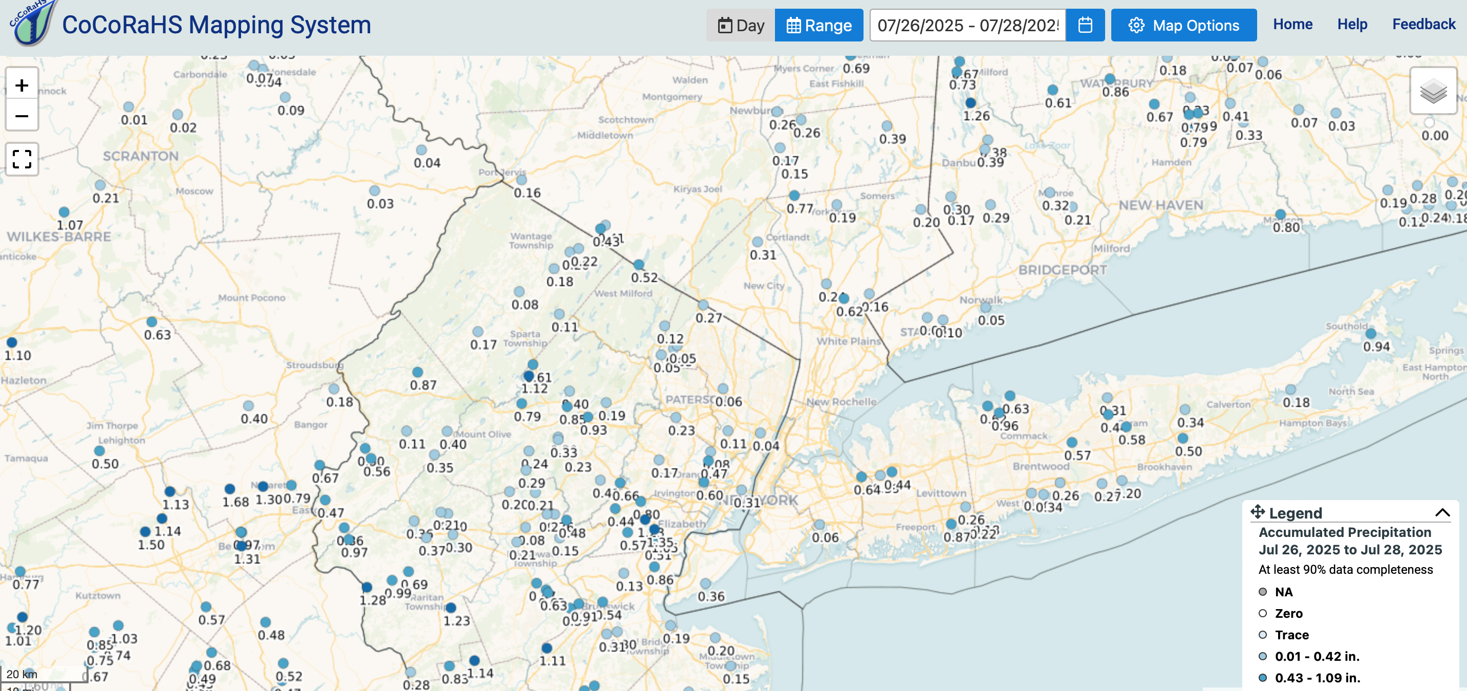
CoCoRaHs rainfall for the Fri-Sun period. Much less than anticipated MAX rainfall. Click for clarity.
-
July 2025 Discussion-OBS - seasonable summer variability
wdrag replied to wdrag's topic in New York City Metro
No thread from me on Tue-Fri til the last minute (Tue morning?). GFS MOS seems a little cool on the maxes Tue and Wed and too low on chance of rain Thu, maybe Fri too. GEFS coming up on qpf now... all ensembles under 2.5" but the EC OP Max #'s are interesting the past two cycles (isolated over 7" location-location?) -
CoCoRaHs totals will be added sometime late this morning.
-
July 2025 Discussion-OBS - seasonable summer variability
wdrag replied to wdrag's topic in New York City Metro
EPS 95-100 TUE and WED. central LI west. Also a 50-60% prob of 1+" in 24 hrs for NJ Thu into Fri. Not threading yet but may combine Tue-Fri morning for the two probable 100"s at KEWR Tue and Wed and a heavy rain event I95 corridor sewd later Wed-Fri... most ensembles not buying the cyclically repetitive EPS R+. Worthy of. monitoring. -
General failure of todays part of the thread. Occurrence too far south.
-
Seemingly capped now... looks pathetic unless something gets going around 2P. Sunday portion of the thread...looking as a failure on my part.
-
Continues interesting... esp NJ. Yes clusters split us north and south and not what I wanted to see at 6A. Still should be some big storms this afternoon in NJ with potential for a small pocket of 4" just southwest of NYC in NJ.
-
July 2025 Discussion-OBS - seasonable summer variability
wdrag replied to wdrag's topic in New York City Metro
Monitoring potential 100F KEWR into central LI Tue-Wed, before a possible widespread heavy rain event late Wed-early Fri when it cools considerably. NWS heat products eventually for Wednesday as well, HI up near 105 then when the worst HI of the next 4 days. -
July 2025 Discussion-OBS - seasonable summer variability
wdrag replied to wdrag's topic in New York City Metro
Not sure if anyone is noticing... near 100 possible central LI Wed... EC past several cycles. then its all done for 10 days. -
Am fairly satisfied with D1... plenty of svr and narrow streaks of 1-1.5". Even 100 at KEWR and daily RER's here and there. Letting late Sat-Sunday play out. Am confident pockets of FF-SVR, ,mainly NJ-LI... Buoyancy will pretty good, better Bulk Shear and larger PW near 2.4". Let's see what happens.
-
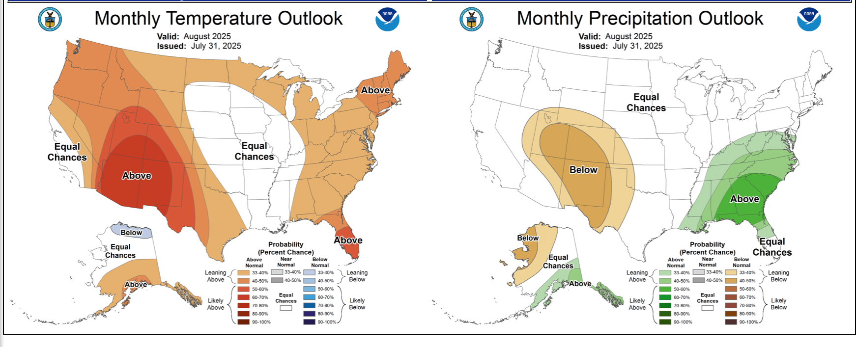
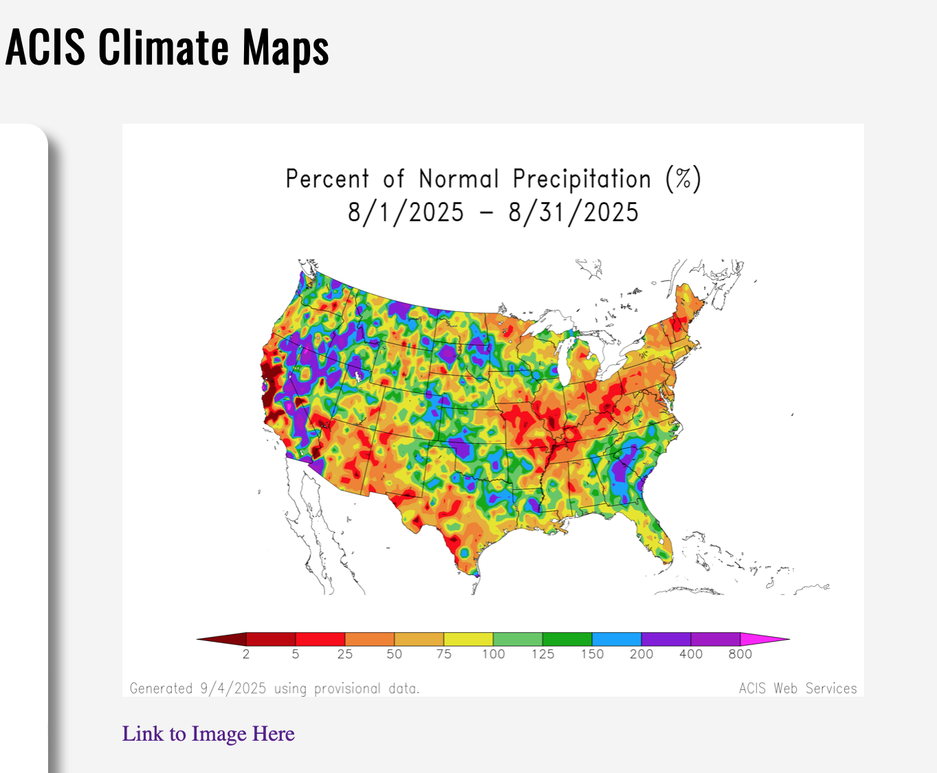
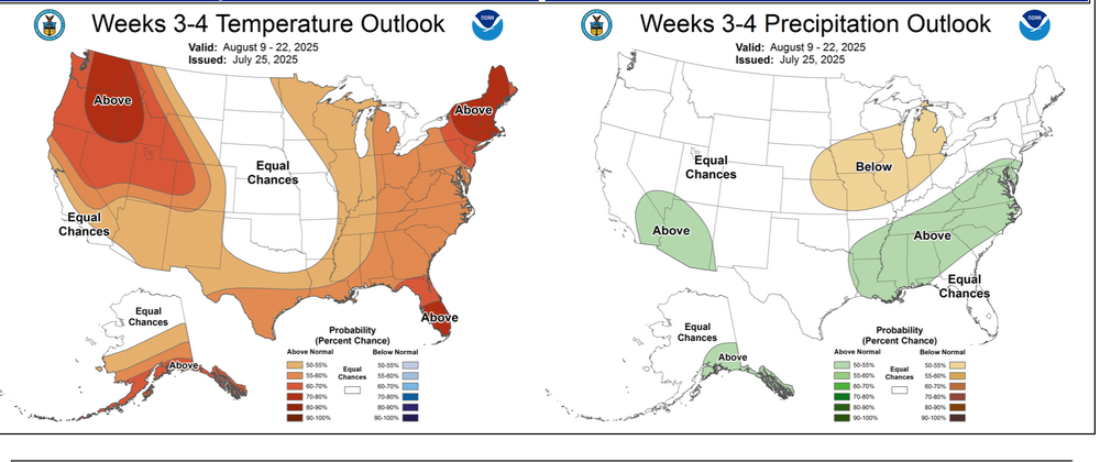
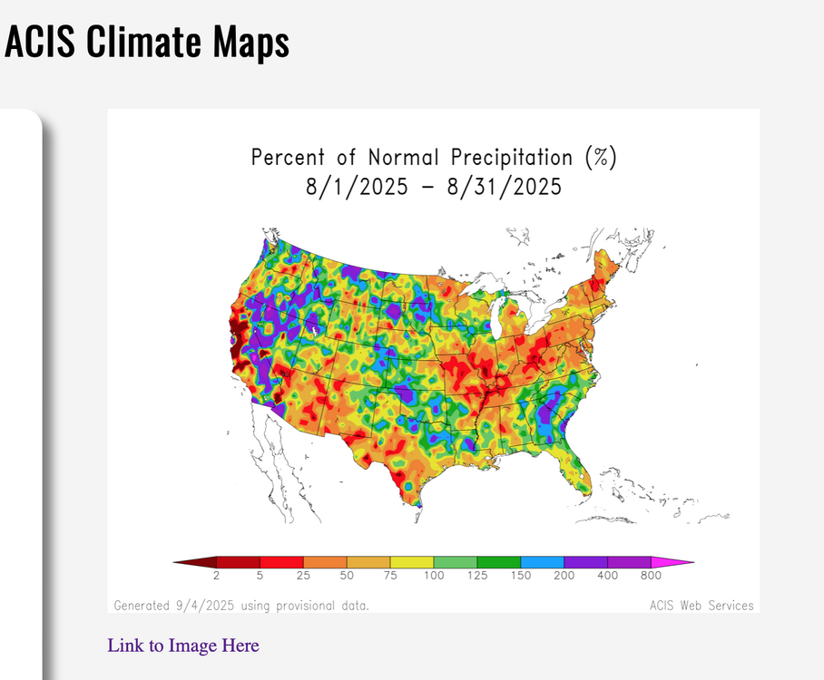
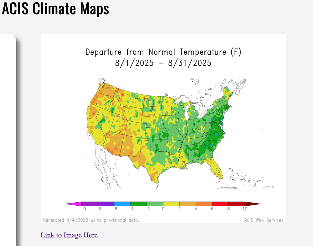
5H Trough generally in the eastern half of the USA this month with a strong ridge in the Rockies, possibly shifting west? Tropics eventually should get going... but impact up here in the NYC subforum unknown to this poster. Added the 7/31 August outlook by CPC on 8/1/25-948AM. Final monthly departures added Sept 5. August monthly outlook in the eastern USA was poor on temps, and somewhat ok on qpf. Just didnt pick up on the extremes.

-
Potency continues for two events... MAY? add up to an isolated 5" storm today by Sunday night along with damaging wind-power outages-local detours. Follow NWS warning products. SPC has a slight risk for SVR today and nothing for Sunday which (imo only) may be underplayed for NJ on Sunday.. WPC has marginal risk for FF this afternoon-evening, again Saturday night-Sunday. Today: Large low level lapse rates may make up for lack of deep instability in a 95-100F max temp environment this afternoon. Fairly progressive sewd moving event but PW around 2" suggests wet microbursts mainly 4P-8P Sunday: low pressure focuses lift Sunday in a potentially more widespread FF event, especially NJ-LI. While instability a little less, the convergence with PWAT almost 2.4" may more than compensate. Be alert traveling late today and Sunday and have alternate plans for delays. Note: There might be late Saturday afternoon heavy showers in north central NJ s of i80 but the real deal is Sunday midnight-3PM. I have not included Tuesday's severe potential---in another thread early next week if my assessment is correct.
-
July 2025 Discussion-OBS - seasonable summer variability
wdrag replied to wdrag's topic in New York City Metro
No thread Fri-Sun but have no changes on expectations...NYC-KEWR 100F has the least certainty. sct svr, iso FF both Fri afternoon-Sunday. Iso 72 hr total 5+. Will recheck with a little more time to digest tomorrow morning 6A. Plan on active Fri aft and Sunday. -
July 2025 Discussion-OBS - seasonable summer variability
wdrag replied to wdrag's topic in New York City Metro
RJAY led the way a few weeks ago. He gets the cred. Very nice pic -
July 2025 Discussion-OBS - seasonable summer variability
wdrag replied to wdrag's topic in New York City Metro
Pretty good chance will issue a thread for Fri-Sun at 8P this evening. Includes SVR FF potential Fri afternoon (in my opinion only-despite weak 5-7H lapse rates T/TD spreads of 30F at max heating 2PM Fri will favor downdrafts-downbursts---especially near NYC) as well as 'possible' first 100F NYC since 2012; and SVR FF Sunday with spot 5" 72 hr total by 06z/Monday. I know the group think is that CP is viewed as a cooling center relative to surroundings. However, EC continues pushing 100 for NYC. We'll see if its too aggressive. -
July 2025 Discussion-OBS - seasonable summer variability
wdrag replied to wdrag's topic in New York City Metro
No threading tonight but continues to look interesting to me Fri-Sun and next Tue before an extended cool down develops late next week. No Aug thread from myself til late Fri afternoon after the CPC week 3-4 issues. -
July 2025 Discussion-OBS - seasonable summer variability
wdrag replied to wdrag's topic in New York City Metro
No threads yet on the following: Fairly widespread SVR late Fri. Spot 5" totals 18z Fri-06z Mon, inclusive of several short duration FF events, primarily Sunday. This may include embedded iso svr. Last chance for 100F this year Newark-NYC seems like this Friday but above normal mean of 90+ occurrences at hand for KEWR as 90+ reoccurs Saturday and Tuesday July 29. Tuesday: nw flow svr event. August: seasonable variability again as per July with a cooler than normal first week, then seemingly wetter and warmer than normal last 3 weeks of Aug as the w Atlantic ridge builds in response to the strong 5H heat ridge near the Rockies, possibly edging west toward the end of the month. Support from 00z/22 GEFS qpf through 700+ hours as seen on Pivotal and spot check of ECMWF INT and the July 17 CPC 1 month outlook. This suggests to me probably no more 100 at KEWR but plenty of 90-95 after the first week of August. Will check in tomorrow -
July 2025 Discussion-OBS - seasonable summer variability
wdrag replied to wdrag's topic in New York City Metro
Fun times ahead for the extremists. As mentioned in several earlier posts this past page or two... EPS is going ahead with two or three 100+ days at KEWR Fri-Sun and an active potential FF pattern Sun-Mon. No thread at this time but the 95+ heat returns with only one caveat...return flow cloud-moisture mid week might temper the actual temp a bit. No thread at this time due to the more seasonably normal nature of the coming events though if it looks like 5+ is assured in some spots, will then thread. NYC 100+ would also need a thread (from my view) but too early for me to confidently express. 579DM 1000-500MB thickness prompts the concerns late this week-weekend. --- In the meantime, I was involved in the FFW results yesterday (Sunday) morning 7/20 , near Lakewood-Point Pleasant NJ where a solid 2-3" drenching occurred 5-630AM. Was lucky not stranded on Arnold St Pt Pleasant (hub cap deep runoff). That was the event I was looking for in the prior long range. but was too small to thread. Back home...have a day. -
July 2025 Discussion-OBS - seasonable summer variability
wdrag replied to wdrag's topic in New York City Metro
for now nd maybe never: no Sat night-Sun thread (FF/SVR). Will review again Fri and Sat morning. Have a day. -
July 2025 Discussion-OBS - seasonable summer variability
wdrag replied to wdrag's topic in New York City Metro
No thread for this afternoon-Thursday activity. Small chance isolated 4+ along the southern edge of NYC subforum (I-195) but not threading. Could be isolated severe per SPC. My main concern is Sunday...combined period of excessive rain and possibly two separate episodes of severe (warm front early morning and cold front in the afternoon). SVR not currently outlooked in the northeast but I think it will be in a day or two. EPS combo plot as seen on Pivotal is of interest. -
I saw the OKX update with the 6+ amounts, many via CoCoRaHs. Thank you. WXUNDERGROUND amounts like my AWN sensor are not qc'd and overall can run a little high in the intense rainfall situations...(stratus plastic is my qc) BUT wxunderground platforms are very good data points that I think warrant consideration by all-especially searching for wx related problems.
-
July 2025 Discussion-OBS - seasonable summer variability
wdrag replied to wdrag's topic in New York City Metro
No new thread til st least 730AM Wednesday. Possibly none till Saturday -
Thanks for the CoCoRaHs posts. That takes care of whatever official posts might have overlooked.