wdrag
-
Posts
5,603 -
Joined
-
Last visited
Content Type
Profiles
Blogs
Forums
American Weather
Media Demo
Store
Gallery
Everything posted by wdrag
-
NJ now up to 15000 meters without power
-
fwiw... and I need to check some guidance but tomorrows 100+ should reach NYC and much of interior w LI. Airmass overhead entire area is similar. Too much real estate for the cooler seabreeze to mitigate before 3PM, especially after a head start tomorrow morning at sunrise of 80+. Pretty good chance interior NJ hits 100 on Wed before storms.
-
No July thread yet... but thinking on it next several days but need go check some stuff. Looks active to me
-
Low this morning Wantage NJ. 76. Dewpoint 74.
-
.01 the part of Wantage at 1030A/22. had rolls of thunder for 3 hours but less than anticipated rainfall.
-
Shower-thunderstorm-cloud debris event today has suppressing impact on MAX T here... hoping we can reach 90-92 at 530P. How it plays exactly I dont know. 00z/06z/22 M-W GEFS and NWS BOM numbers a little less than the amped EPS. Can't be sure what happens and for now stay the course...but offer hope that this heat episode might not be quite as dire as headlined but still significant life impact in our area. Urging: Continue preparedness as stated in NWS products. Seems like better chance for the headline 4 day period verifying in Philly--DC areas. They're pretty used to this mid summer but no doubt it's still a vigorous potent early season heat episode. Action packed afternoon-evenings late Wed 6/25 into early July and lawns-gardens will have brief significant dousings etc. In essence... headline confidence slightly lower but will let the numbers decide the next 4 days.
-
12z/21,EPS continues 100+ Mon_Tue and 100 Wed. Tomorrow 94-99. So despite the EC op cooler its overall ensemble agreement is not large. Continue as is stated. My guess ERs will be deluged with heat related illness next 4-5 days. No fun if you can’t urinate. Think it’s a catheter before you discharge from the ER. You don’t want to have to deal with that til you’re very old. hydrate properly. Follow the call to actions.
-
Agreed. Ensembles smooth this out. I did notice BOM several dege cooler than EPS.
-
That’s a start. Everyone has seen single op model back door interruption 12z Mon NAm and TUE EC
-
Newark I think hit 90 before 2PM
-
Perfect. Thank you very much Don!
-
Perfect. Thank you very much Don!
-
-
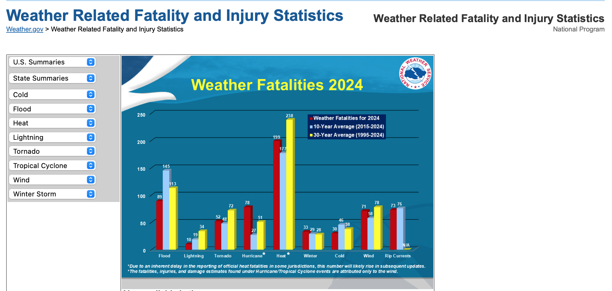
My concern with this east coast heatwave is heat related fatalities... I could be reading this wrong and someone else can post more realistic perspective.
-
Looks to me like action packed 10 days ahead. Maybe someone can add the latest on EFI temp here, as well as all time record max NYC, EWR... last time 100 NYC. We already have the basics in the opener graphics. Noting PWAT near 2" Wed eve-Thu morning. Could be local wet microbursts and FF in our area but that is not intentionally covered in this thread. May add it early next week but only if it includes Wed. This thread is first and foremost dedicated to coming heat in our NYC suboforum and whether the EPS over did it? I am always cautious on extremes as I was in Sandy... and here too but we have to use the science to the best of our ability to mitigate adverse impact. and the science is improving. Brownouts coming NYC? This 4 day period is human-pet threat, especially the vulnerable young-old, limited cognitio and wherewithal. Good to prepare to to monitor and assist where needed. HW I think begins I95 corridor in NJ today with first 90. Probably my last on this today
-
but consider that forecasters do not like egg on their face so to speak... none of us like to be wrong. In this case confidence is high that problems will develop of the magnitude described. Yes watch is less confident than warning,
-
Busy w granddaughter but I think terminology has changed. UNUSUAL for NWS to issue a watch 3-6 days in advance. Confidence high on problems. In the Deep South they might handle it better?? but here its sudden onset and magnitude. Ensembles continue 100+ for the I95 corridor.
-
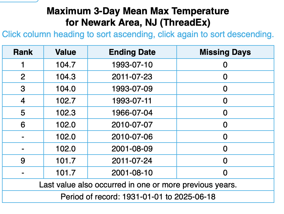
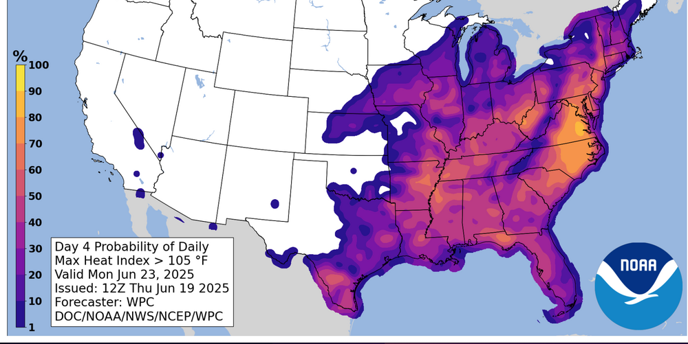
Model guidance (especially European) for days has been forecasting 100 degree heat, with the potential suppressants being early developing daily sea breezes and/or thunderstorms-clouds debris. While severe storms cause damage, excessive heat can cause fatalities if not properly prepared. Please follow NWS guidance and advise of local officials-cooling centers, hydrating etc as this heat wave develops. The Heat Wave 'may' break next Thu-Fri before reasserting for another opportunity at 100F next weekend - June 28-29. June record stats in the 90+ year Period of Record (POR)... 100+. Newark 2 days, NYC CP 1. Yearly warmest 3 day max temp period ever in Newark over the 90+ period of record. We MAY??? crack top 10. See attached graphic. Added Preparedness statistics graphic...believe--especially urban centers which may not cool below 82 degrees Monday and Tuesday nights. HEAT on average is the highest fatality hazard. WPC statistical probability of MAX HI on the 23rd is added... from the graphic you can see that is a 50-70% chance in the interior. post completed 1105PM/19
-
I will start a thread on what may be the hottest stretch of our summer (KEWR Mean temp and 2-3 100 degree days interior between Sun-Wed), with 1-2 days of 100 NYC in this period. Beyond, this heat wave, it (90 or higher) possibly lasts through all of June and another surge of 100+ heat 28-30. I'll concentrate on the Sun-Wed period for a start. Thread may not post til after 10P. 90 not likely tomorrow in the interior but I think a decent chance of starting Saturday afternoon.
-
Long daylight. Max t could be 11a or 5P. I’ll check tonight but I think mcs will rise through by sunrise Sunday
-
am rushing so won't make a final decision for 2-3 100F days M-W KEWR area (interior NJ in our subforum). Probably a pretty good chance for NYC to get at least one but want to rereview at 9P. Heat wave officially begins interior NJ Suun, possibly touching 90 Sat). HW ends sometime between Thu-Sat next week dependent on backdoor. No time to assess SVR. Use among your tools SPC and BOM. Have a day, Walt
-
I haven't had a chance to review all the posts last 4 hours, but from my vantage point. THREE 100 deg days in June is still a possibility INLAND NJ-NYS/CT, BUT, same caveats as yesterday... pattern isobars show quite a bit of weakness so its easier to Seabreeze early in the season, plus T STORM cloud cover debris is unknown. (not sure how EC spreads 100 so far inland across LI/NYC next week and so I have to expect some tempering of those excessive projections in the weekend updates). I think 00z/18 GFS MEX MOS is wayyy too cool on daytimes for KEWR but its something to keep in mind. Thursday max at KEWR is my decision break point on any 100 degree thread for next week that would possibly issue Thursday evening. I've no plans to thread tomorrows fairly widespread severe wind potential along I95. Am pretty sure we'll see a a nw flow MCS - iso severe in NY metro early Sunday morning as the warm front returns. My KEWR 90 degree days are Thu, possibly both Sat/Sun, certainly Mon-Wed and then maybe again Thu and Sat of next week with 3 100's possibly??? embedded between Mon-Sat of next week. SVR potential in slow moving deluges wherever sea breezes intersect next Mon-Tue (if not capped). Noticed besides the 2-4K J ML Cape early next week- there are rather large 7H-5H lapse rates. IF something goes, would be microburst w hail/wind/ flooding...thats IFFFF.
-
Have briefly scanned 12z EC... unbelievable next week. Just have to play it conservative but as above ... am in agreement. My north Jersey senior softball (age 60-68 and 69-80+) for Tue morning... probably 250 players idled for the second Tue in a row by wet ground. Next week, heat warning may preclude a second game at 1130A and just a 10A. just for the fun of it.
-
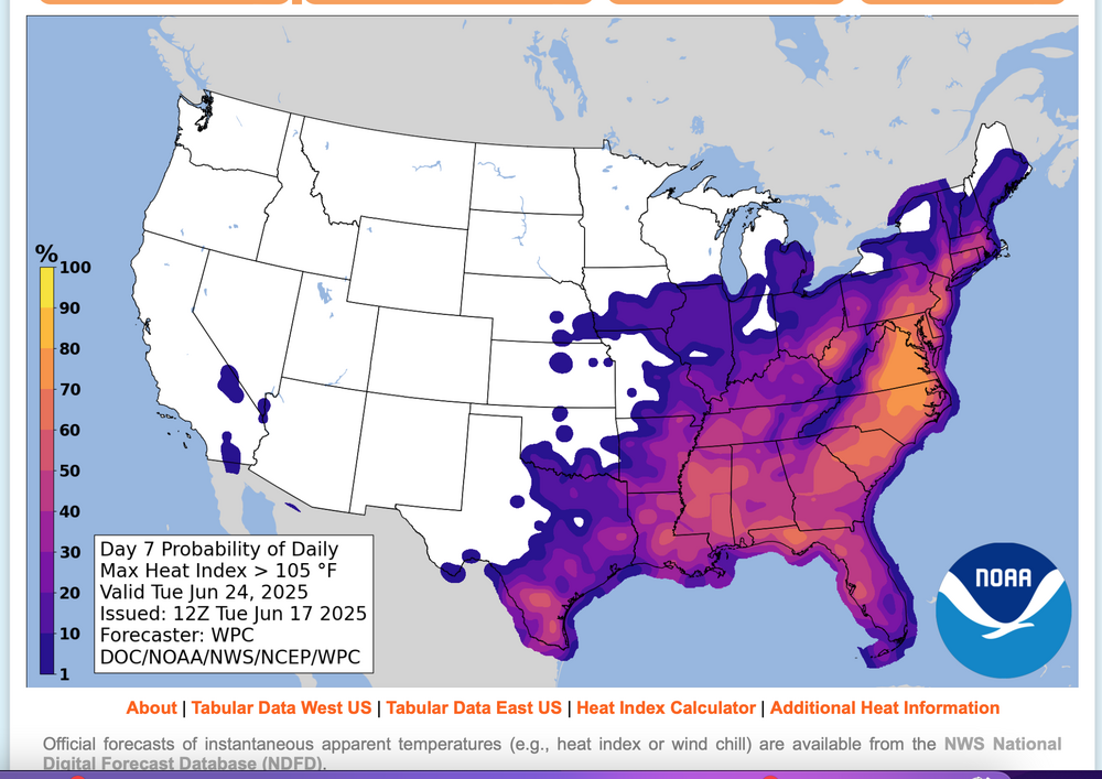
Considering, but not acting upon a possible thread for interior NJ first June 3 or more 100 degree days, occurring next week. Blend of Models is several degrees under 100. I want to see how temps play this Thursday (KEWR 90?), and subsequent modeling. Much can interrupt excessive heat, including sea breezes, thunderstorms, cloud debris. TOO early but for me, worthy of monitoring. 105 "heat index" - think that is our warning criteria up here, has according to WPC statisitcs is around a 60% chance of occurrence Monday and Tuesday. Here is Tuesday's early morning WPC prediction for Tuesday. Click for clarity and use the graph for probability interpretation.
-
No changes from my Sunday morning post... except to add the small potential for a nw flow severe event Sat afternoon, especially eastern parts of our area (CT/LI). That in addition to whatever happens this Thursday as currently outlooked by SPC. I looked at XMACIS and there just isn't any need from my perspective for a heat thread. What is coming is sort of normal for June, especially interior. The sudden change will take a few by surprise but little doubt in my mind we experience heat advisory (June 95-100) interior Thu afternoon, and then possible heat warning or however the NWS titles it for early next weeks MAX HI 100-105. Duration (4 day or 7day+ heat wave of 90+uncertain for KEWR) but I think heat wave likely begins Sunday afternoon. Right now WPC max HI only goes out to Monday and is more conservative.