wdrag
-
Posts
5,603 -
Joined
-
Last visited
Content Type
Profiles
Blogs
Forums
American Weather
Media Demo
Store
Gallery
Everything posted by wdrag
-
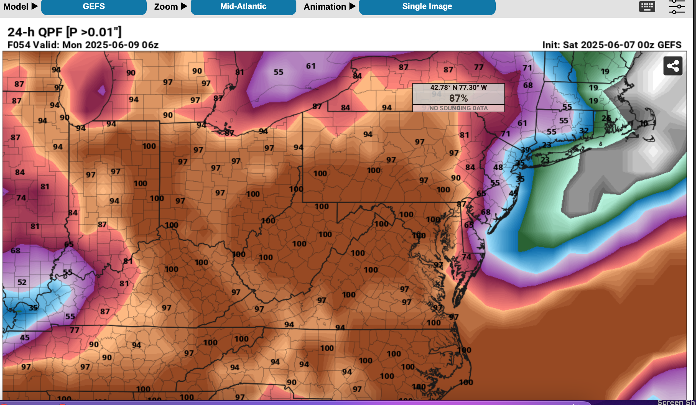
Ill be off line most of the rest of the day so wont be able to comment further. Lets first see if Newark can indeed make 100 early next week. It should feel 100+ but whether we can get to 100... 9 days in advance??? I've no reliable certitude.
-
For the record: Only Newark below. POR 1931. 8 summers had 100 in June as the warmest. Therefore the preponderance of 100 degree days did occur JA, generally not more than 2 days a month though a few big months which you can reference, especially for those that are using analog years. Eyeballing, the 1990s stand out a bit to me. METADATA may be important there which I did not check. ASOS install, locations etc. Bottom line this spells out the hottest days (not necessarily hottest summers). Don and others may be adding more. Thank you to the NWS collaboration developing XMACIS and to all the global researchers- modelers that develop and allow us view meteorological modeling. It is illuminating and can be useful perspective. You can figure out the columns for JJA Monthly Number of Days Max Temperature >= 100 for NEWARK LIBERTY INTL AP, NJ Click column heading to sort ascending, click again to sort descending. Mean 0 0 0 0 0 0 1 0 0 0 0 0 1 Max 0 2025 0 2025 0 2025 0 2025 0 2025 2 2021 5 2022 4 1953 1 1993 0 2024 0 2024 0 2024 9 1993 1931 0 0 0 0 0 0 0 0 0 0 0 0 0 1932 0 0 0 0 0 0 0 0 0 0 0 0 0 1933 0 0 0 0 0 0 1 0 0 0 0 0 1 1934 0 0 0 0 0 1 0 0 0 0 0 0 1 1935 0 0 0 0 0 0 0 0 0 0 0 0 0 1936 0 0 0 0 0 0 2 0 0 0 0 0 2 1937 0 0 0 0 0 0 1 0 0 0 0 0 1 1938 0 0 0 0 0 0 0 0 0 0 0 0 0 1939 0 0 0 0 0 0 0 0 0 0 0 0 0 1940 0 0 0 0 0 0 0 0 0 0 0 0 0 1941 0 0 0 0 0 0 0 0 0 0 0 0 0 1942 0 0 0 0 0 0 0 0 0 0 0 0 0 1943 0 0 0 0 0 2 0 0 0 0 0 0 2 1944 0 0 0 0 0 0 0 4 0 0 0 0 4 1945 0 0 0 0 0 0 0 0 0 0 0 0 0 1946 0 0 0 0 0 0 0 0 0 0 0 0 0 1947 0 0 0 0 0 0 0 0 0 0 0 0 0 1948 0 0 0 0 0 0 0 2 0 0 0 0 2 1949 0 0 0 0 0 0 5 3 0 0 0 0 8 1950 0 0 0 0 0 0 0 0 0 0 0 0 0 1951 0 0 0 0 0 0 0 0 0 0 0 0 0 1952 0 0 0 0 0 1 0 0 0 0 0 0 1 1953 0 0 0 0 0 1 0 4 1 0 0 0 6 1954 0 0 0 0 0 0 2 0 0 0 0 0 2 1955 0 0 0 0 0 0 3 1 0 0 0 0 4 1956 0 0 0 0 0 0 0 0 0 0 0 0 0 1957 0 0 0 0 0 0 1 0 0 0 0 0 1 1958 0 0 0 0 0 0 0 0 0 0 0 0 0 1959 0 0 0 0 0 1 0 0 0 0 0 0 1 1960 0 0 0 0 0 0 0 0 0 0 0 0 0 1961 0 0 0 0 0 0 0 0 0 0 0 0 0 1962 0 0 0 0 0 0 0 0 0 0 0 0 0 1963 0 0 0 0 0 0 1 0 0 0 0 0 1 1964 0 0 0 0 0 0 0 0 0 0 0 0 0 1965 0 0 0 0 0 0 0 0 0 0 0 0 0 1966 0 0 0 0 0 1 4 0 0 0 0 0 5 1967 0 0 0 0 0 0 0 0 0 0 0 0 0 1968 0 0 0 0 0 0 0 0 0 0 0 0 0 1969 0 0 0 0 0 0 0 0 0 0 0 0 0 1970 0 0 0 0 0 0 0 0 0 0 0 0 0 1971 0 0 0 0 0 0 0 0 0 0 0 0 0 1972 0 0 0 0 0 0 0 0 0 0 0 0 0 1973 0 0 0 0 0 0 0 1 0 0 0 0 1 1974 0 0 0 0 0 0 0 0 0 0 0 0 0 1975 0 0 0 0 0 0 0 0 0 0 0 0 0 1976 0 0 0 0 0 0 0 0 0 0 0 0 0 1977 0 0 0 0 0 0 2 0 0 0 0 0 2 1978 0 0 0 0 0 0 0 0 0 0 0 0 0 1979 0 0 0 0 0 0 0 0 0 0 0 0 0 1980 0 0 0 0 0 0 2 0 0 0 0 0 2 1981 0 0 0 0 0 0 0 0 0 0 0 0 0 1982 0 0 0 0 0 0 1 0 0 0 0 0 1 1983 0 0 0 0 0 0 0 0 0 0 0 0 0 1984 0 0 0 0 0 0 0 0 0 0 0 0 0 1985 0 0 0 0 0 0 0 0 0 0 0 0 0 1986 0 0 0 0 0 0 1 0 0 0 0 0 1 1987 0 0 0 0 0 0 0 0 0 0 0 0 0 1988 0 0 0 0 0 1 4 0 0 0 0 0 5 1989 0 0 0 0 0 0 0 0 0 0 0 0 0 1990 0 0 0 0 0 0 0 0 0 0 0 0 0 1991 0 0 0 0 0 0 2 0 0 0 0 0 2 1992 0 0 0 0 0 0 0 0 0 0 0 0 0 1993 0 0 0 0 0 1 4 3 1 0 0 0 9 1994 0 0 0 0 0 2 0 0 0 0 0 0 2 1995 0 0 0 0 0 0 1 0 0 0 0 0 1 1996 0 0 0 0 0 0 0 0 0 0 0 0 0 1997 0 0 0 0 0 0 2 0 0 0 0 0 2 1998 0 0 0 0 0 0 0 0 0 0 0 0 0 1999 0 0 0 0 0 0 3 0 0 0 0 0 3 2000 0 0 0 0 0 0 0 0 0 0 0 0 0 2001 0 0 0 0 0 0 0 3 0 0 0 0 3 2002 0 0 0 0 0 0 1 1 0 0 0 0 2 2003 0 0 0 0 0 0 0 0 0 0 0 0 0 2004 0 0 0 0 0 0 0 0 0 0 0 0 0 2005 0 0 0 0 0 0 1 2 0 0 0 0 3 2006 0 0 0 0 0 0 0 3 0 0 0 0 3 2007 0 0 0 0 0 0 0 0 0 0 0 0 0 2008 0 0 0 0 0 0 0 0 0 0 0 0 0 2009 0 0 0 0 0 0 0 0 0 0 0 0 0 2010 0 0 0 0 0 0 4 0 0 0 0 0 4 2011 0 0 0 0 0 1 3 0 0 0 0 0 4 2012 0 0 0 0 0 0 3 0 0 0 0 0 3 2013 0 0 0 0 0 0 2 0 0 0 0 0 2 2014 0 0 0 0 0 0 0 0 0 0 0 0 0 2015 0 0 0 0 0 0 0 0 0 0 0 0 0 2016 0 0 0 0 0 0 0 0 0 0 0 0 0 2017 0 0 0 0 0 0 0 0 0 0 0 0 0 2018 0 0 0 0 0 0 0 0 0 0 0 0 0 2019 0 0 0 0 0 0 0 0 0 0 0 0 0 2020 0 0 0 0 0 0 0 0 0 0 0 0 0 2021 0 0 0 0 0 2 0 0 0 0 0 0 2 2022 0 0 0 0 0 0 5 1 0 0 0 0 6 2023 0 0 0 0 0 0 0 0 0 0 0 0 0 2024 0 0 0 0 0 1 0 1 0 0 0 0 2 2025 0 0 0 0 0 0 M M M M M M 0
-
I will monitor... I certainly wouldn't be advising an emergency manager. I'm not an analog forecaster.
-
No sure why you say that? Explain? I dont see it in the means which I know are not necessarily reliable but all I can go on. I tend to see this coming heat as significant but July/August? Don might something more to say then what I'm seeing, which is reoccurring troughing in the east and maybe more ridging developing in the Atlantic, implying bouts of wetness alternating with humid heat. Typical above normal temp summer....but in the means but I cant think of 100. Modeling can be overexhuberant beyond a week. So I plan shorter term. Tuesday doubleheader softball hopefully gets in before the next bigger rain, and then the 24th, we may need to plan second game midday starting with a shorter count to avoid cooking our 70 and 80 year old players. That's how I plan.
-
Good Sunday morning, Heat is obviously coming now and interiors slated for an above normal number of 90+ days in June. Thursday may be a heat advisory afternoon for interior NJ (EWR etc). Also mixed layer Cape over 1500J with Bulk Shear >30 kits suggests potential for SVR. Timing timing timing. Then the heat wave, first of the year probably for most of us except water influenced coastal spots (Sunday-approximately around Wednesday of next week), possibly longer with widespread heat advisory conditions early next week, possibly a heat Warning coming for some spots. Interestsingly enough while ML CAPE is high early next week, Bulk Shear is low so any SVR Thunder may be more isolated, local convergence initiated. Recent abo e normal rainfall and another event coming before the heat... that will help with higher dews and possibly lower max temp potential a deg or two. Nevertheless, HOT looks to be on the way.
-
91+ at KEWR today...so interior NJ I think is well on its way to a normal or above normal month of 90 or higher via KEWR verification. Possibly near normal qpf too? Associated with oscillating warm-cool spells. KEWR normal 90 in June, please correct me if I'm wrong = FIVE? So far two. Two to 4 more modeled possibilities 6/19, 6/21-22, 6/25-26? Beyond...havent checked.
-
Presuming everyone is fully aware of the GFS failure., attempting to spin up a TS vcnty GMEX the past week or so.
-
Hi. fwiw...the post was associated with the late Sunday (8th) northeastward moving weakening lead short wave. Not the10th.
-
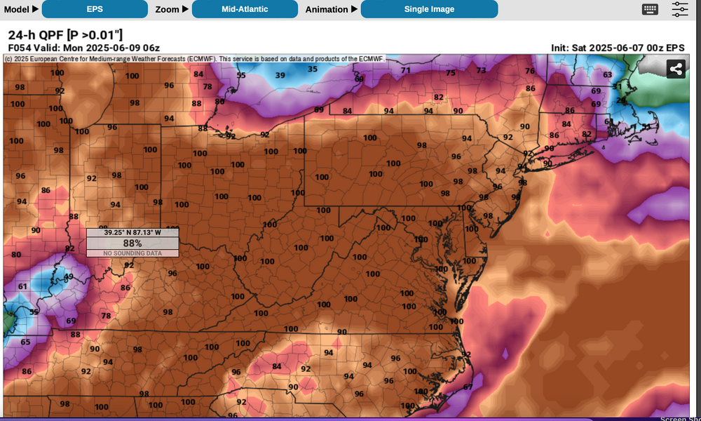
Also: fwiw.. ECAI had this mornings NJ rain nailed every cycle back to 174 hours per Trop Tidbits "prior version" 6 hrs ending 12z. GFS Op was not quite as consistent. If interested, take a look. This rain impacted outdoor activities this morning in NNJ.
-
Briefly reviewed... GEFS/EPS Blend would have been best as it rained through most of Nj but mainly sprits LI.

-
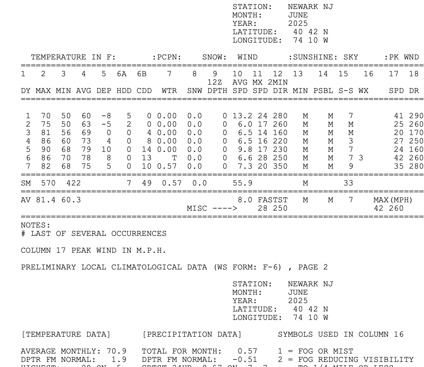
First 7 days of June inland as represented by KEWR Climate (five 80+)... Cooler than this for the coasts. CP at +1.1 for the month and only 3 days of 80.

-
Looks wet at times, daily through Tue... added the Prob of >0.01 from wet 00z/7 EPS and drier GEFS. I wouldn't promise anyone a dry Sunday afternoon-night... just by natural, albeit weakening northeastward ejection of the lead short wave, I would think rain would impact. our area later Sunday. When to mow if you didnt yesterday... for me up here, window of opportunity 4P today to 2P Sunday. Attached probs. Next chance of 90 interior seems next Thu-Fri though ensembles dont play it up. Very rapid warming again after the trough aloft our area Tue-Wed lifts northward, similar to this past Wed-Fri. Will add first week CF6 for Newark tomorrow morning.
-
Morning Don,
Noticed no MO projection for June? Too uncertain?
Probably no skill determining which summer month might be warmest departure?
Checking in,
Walt
-
On the 7th I'll toss up a CF6 for the first 7 days at KEWR.... whose data seems hot to some of us but likely is not per NWS tolerances for ASOS Data. Whether we can muster 90 this Thu or Fri is doubtful to me (17C 850) and smoke aloft which I suspect is knocking off a deg or 2 on daytime max. Looking ahead 13th-20th first day of summer... I'm taking a stab here but unless compromised by sea breezes or midday showers, looks to me like a pretty long stretch of a above normal temps as Both the EPS and GEFS are developing a significant ridge somewhere between 80 and 95W...Ie Great Lakes-Upper Midwest. That should mean warming here with possible cool frontal passages, but also possible shots at 90F for at least the interior. Have a day
-
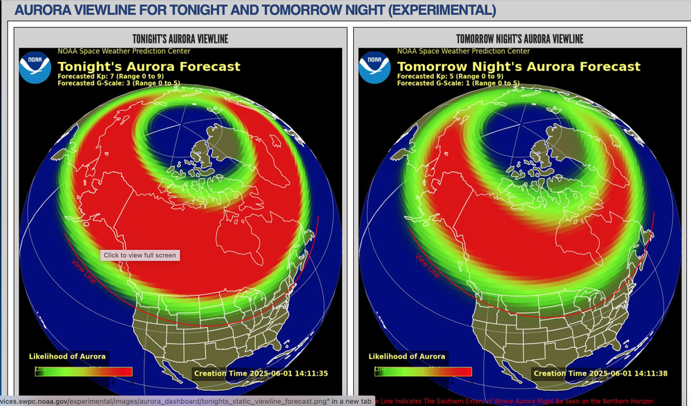
0.08 last night 8P-midnight in Wantage NJ. No clear cut aurora at 3A today on camera.
-
YES Aurora possible, imo best time to view if we get it 11P-430A when skies hopefully clear an smoke drifts to the east. As others noted camera picks up what the eye wont.
-
Yes I see that... I'll recheck their numbers at 6PM when the new issuance arrives. AND... hoping middle deck WAA clouds ahead of a weak boundary does not complicate things after 9PM. Better chance of clear skies south and west of us.
-
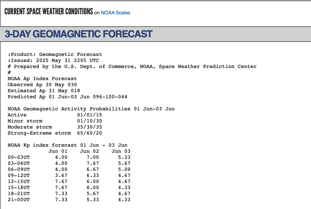
Thanks for the alert. KP values very good but not sure if we can see it down here after sunset. Please see attached.
-
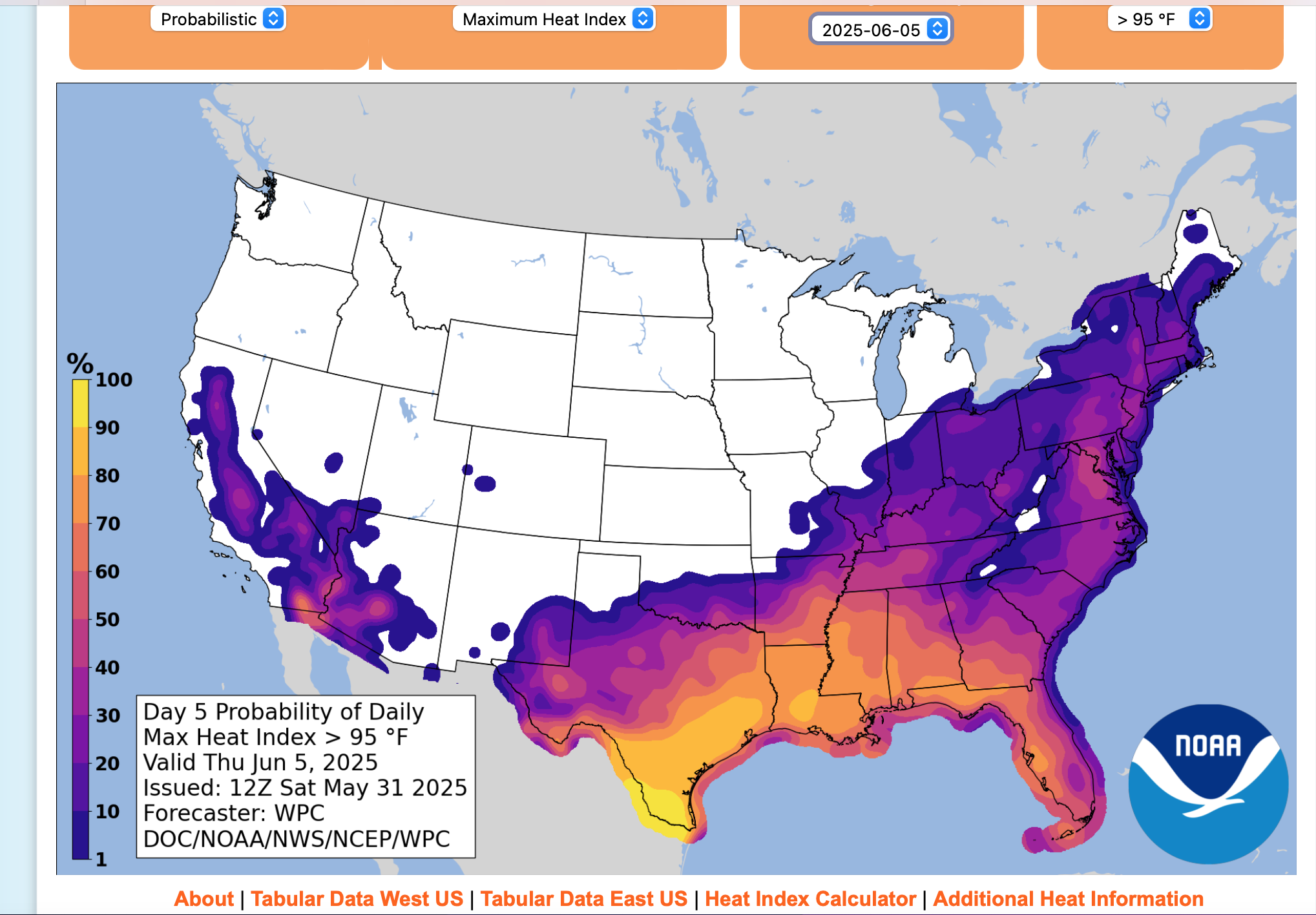
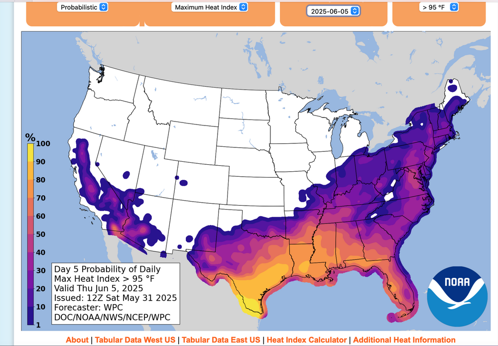
New product from NWS... I like it. No hover output-unfortuntely, but probabilistically a 30-40% chance of a Max HI 95+ on Thursday interior NJ.
-
12z/31 Guidance including ensembles continues 80s inland Tue-Fri, possibly weekend, with 90 possible Thu-Fri...even NYC??? AC will be needed parts of the inland areas Thu-Fri afternoon. So far, below June heat advisory guidance (I think still lower threshold in May-June than JAS) this coming Thu-Fri.
-
Davis seems top of the line for us enthusiasts
-
My final in Wantage for the 11 hour rain event 2.03 ending 11A. Fits NJ climate data as well as NYS Mesonet.By the way that is .23 LESS than the automated AWN... tips too much in heavy rain.
-
Maybe not in the country but different in the city... less relief! I think departures are important, be it night or day. We need to continue reviewing.
-
Will be interested in knowing statistically what summer (JJA) month will see the greatest departure from normal. I saw Don's post on +1 summer. Not sure this is substantial but one of these months might show up larger departure.
-
TROPICAL: Personal opinion is to follow the Tropical portion of AM WX... just too early to get excited. I dont see any clear GEFS/EPS signal for an event GMEX-FL coast yet.