wdrag
-
Posts
5,603 -
Joined
-
Last visited
Content Type
Profiles
Blogs
Forums
American Weather
Media Demo
Store
Gallery
Everything posted by wdrag
-
fwiw: Today might be a good day for housekeeping on locations of our various posters. Mine comes up pretty clean but for many on here, I've no clue. Might be good to edit more detail. Thanks for considering value added.
-
Wantage NJ at Noon. 0.1" from the snow showers since 9A. pavement wet...melting on pavement contact. 32.5 and still snowing at 1211PM 11/30/25. For those wondering where am located -- southern Wantage NJ which I consider part of i84 corridor-keeping posts simple.
-
Wantage NJ 32.7 maybe 0.2 on some of the grass - dirt but cant officially measure as melt son contact. still snowing at 1118A
-
That's correct... presuming temps at 5-6A are 31. Am not absolutely sure they will. be that cold in the cities. EC AI slightly warmer. No matter, intensity at onset matters. Also, by the time this gets here, I would think DPW's have treated cities to make it easier for the urban centers of I95. Otherwise some troubles lurk for the interior, including wet snow acc of 4" or more causing a few tree limbs to break s CT to NNJ
-
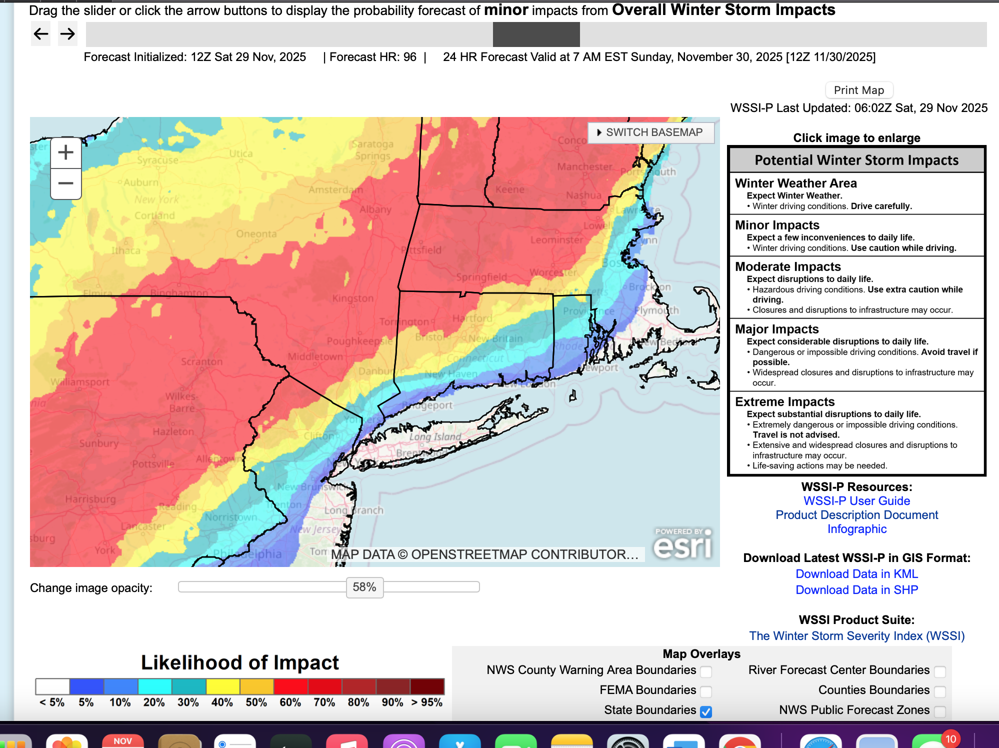
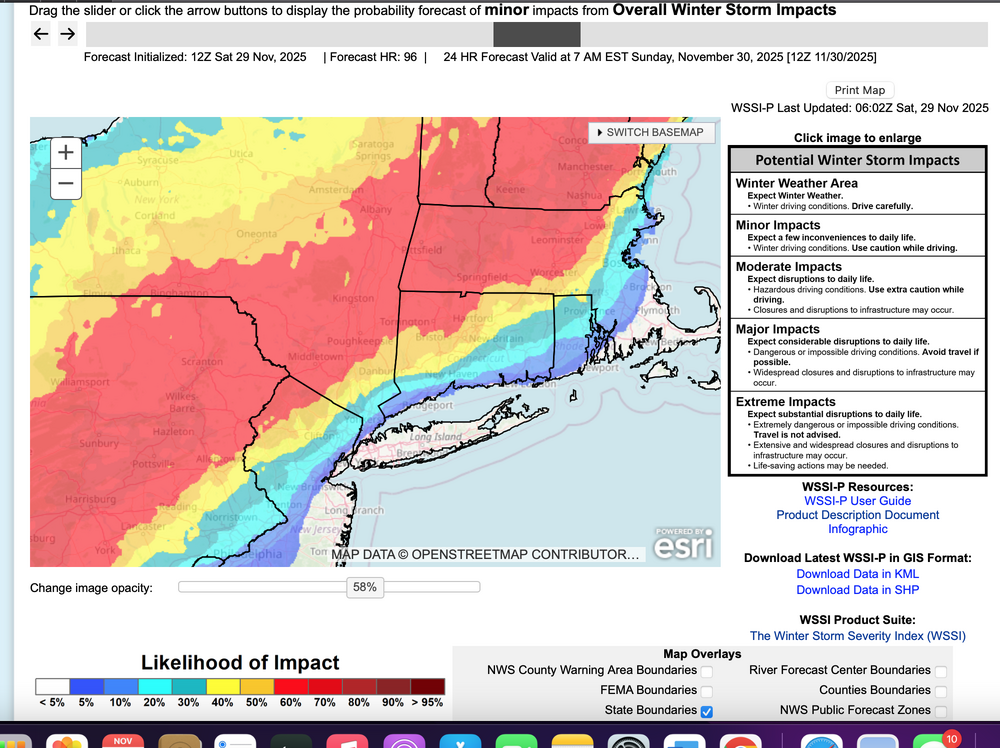
The southeastern edge of this wintry event should lie along the Interstate 95 corridor and include NYC-Philly-DC-Baltimore where a minor accumulation of sleet or snow occurs during the Tuesday morning rush hour. For these I95 urban centers, lets count on 0.1-1" of snow sleet at the start but probably not much of a problem due to anticipated melting on pavement. Still I'd leave a little earlier there and count on rain by 10AM. No change from me on the thread headline. That's my take at 7AM
-
I see just about everyone has tossed in the towel. So for now it's the best global modeling in the world (EC-EPS ECAI) vs all the other warmer model runs. Results ahead... front end could be a little bit of accumulative fun for us Tuesday morning. Will check back tomorrow to see if my over reliance on these colder cycles have any validity going forward.
-
You'd have to believe the Euro has more data and later input time... and more reliable (at least I do). I am sort of surprised it doesn't amp. ECAI does amp and plenty of snow interior. I'll be watching AI temps at 18z and 00z//3 carefully for trends on AI. Banding of wet snow could be a problem for some tree branches just s of I84 in nw NJ sw CT.
-
That's what I just saw as well. Research prior to the birth of many younger mets. I still think it worthwhile for forecasters who have time, to run a quick check.
-
Tech Attachment from 1989 attached> references an older set of models but the pattern still applies. See the checklist. https://www.weather.gov/media/erh/ta/ta88-17b.pdf
-
For what this is worth... has anyone checked BOX, OKX and discussions... I dont quite have time... but I'm thinking this rapid transition of an end moving- strengthening shortwave across our area with strong LFQ and even stronger RRQ of 250-300MB jets may fit the bombogenesis profile. Let us know if anyone has mentioned this? PPP drops at least 24 MB in 24 hrs 12z Tue-12zWED. I'm believing rapid intensification and now it's a matter of thermal profiles. Going to be an interesting day in these parts with R+ LI and a "period "of S+ wet snow inland. mPing of value Tuesday including the possibility of a northernly jet 40kt plus on the backside over LI as the storm rushes east northeast.
-
My first indicators of how future modeling will go, the NAM and RGEM. RGEM tends to be a warmer model. NAM tends to be quite amped at times. Still, I need to know whether NYC is still in the game for first measurable of the season. If the NAM 60-84 have NYC in some sort of snow, especially early Tues...thats good news, not necessarily correct. If the RGEM is likewise earlier and colder ptypes=qood news. You'll be more to date than I but that's how I read Global tendencies (OFF the mesoscale models - NAM supposed to go away in 2026). I do think the GFS is and has been too amped but this will be a significant short wave cutting east across NJ 00z/Wed so I foresee intensification as it rips negatively out into the north Atlantic. Tremendous RRQ lift from the St Law Valley 250MB 180 speed max.
-
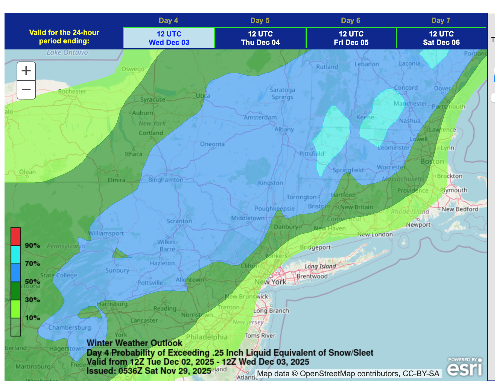
This thread headline looks good based on casual look at info through 06z/29. NYC CP might see their first measurable snow-sleet. Back later today. Ensemble WSSI-P graphic -06z/29, and ensemble prob for 3+" of snow (legend color code probs) hopefully speak for themselves.

-
12z/28 ECAI OPPPPP took a big step north in concert with its prior cycle ensembles. EC op has tiny touch of snow acc Tuesday night in the storms departure on w and n LI... garbage but maybe it will be something? Plan for less and enjoy mPing if its provides hope Tue AM and Tue night. Four days away so still model adjustments will occur. n/c to threadline attm.
-
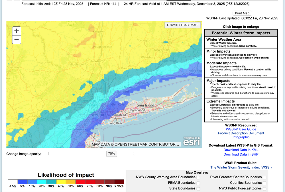
Based on ensemble guidance seen through 06z/28, a rapidly intensifying and fast moving coastal low will bring a variety of weather elements to the NYC subforum. Periods of moderate to heavy rain are expected coastal areas- preceded by a little snow-sleet near dawn Tuesday and to closeout the storm Tuesday evening, while a period of heavy snow-sleet seems likely for the interior, especially the I84 corridor. Gusty northerly winds to 45 MPH are possible for eastern Long Island in the early Wednesday morning departure. Due to the late development and rapid departure of the storm, the chance of coastal flooding is minimal. All ensembles including ECAI have significant precipitation. This may be Central Parks first measurable snow-sleet of the season, though temps at or just above freezing at sunrise Tuesday may preclude onset measurable in the city. Delays are anticipated over the interior hilly terrain with possible school closings or early dismissals along and north of I80, especially the I84 corridor from the Poconos across se NYS into CT. One attached graphic (WSSI-P) shows the potential for a minor impact event per the NWS inputs for the their 1AM Friday forecast.
-
While no wind thread today... am getting a tracking thread started for Tuesday by 930AM,
-
Holding off 12 hours til 7AFri. 18z ECAI still south but the ECAI Ensemble is not... its similar to the blend EPS-GEFS (melting LI, I95 itself eastward).
-
Am at Thanksgiving family dinner. If All goes well one or two threads will begin 9pm tonight or7am Friday. If it’s snow it will be for odds on CP first measurable snow sleet No time to elaborate right now. Have a wonderful family dinner. Walt
-
Thanksgiving prevails... Create new family memories and think about those who cannot be with us. Still contemplating a thread for Friday... I think there will be wind gusts to 40 kt at all the airports, but may be will fall short by 3KT. Marginal except if you have no power. Also even though its not in most forecasts, I'll be looking for many flurries in NYC metro Fri afternoon.
-
Thanksgiving prevails... Create new family memories and think about those who cannot be with us. I think Dec 2-3 will need a thread for first measurable sleet-snow NYC CP with a potential moderate snowstorm I84 corridor with coastal flooding Late Dec 2, early Dec 3 high tide (lunar abnormal). Also, Dec 7ish is dependent on whether the initial short wave is stronger per the EPS or whether the GEFS trailer into the Plains states prevails. In any case this looks to be an interesting two weeks of stratwarm aided early winter opportunities. Also even though its not in most forecasts, I'll be looking for many flurries in NYC metro Fri afternoon, isolated brief dustings inland from I95.
-
Dec 2-3 with snow interest, especially I84 where the prob for an inch or more is 50%. Dec 6-7 very uncertain due to large scale modeling differences. I would think these are our first two chance for minor measurable CP.
-
Already 40kt KMPO. Difficult to believe we won't have fair amount of G40 kt Friday as the very cold trough aloft sweeps by and can in its wake arrives with flurries. No time for a thread today.
-
I84 corridor next Tuesday: A snow and ice event is modeled with uncertain amounts but may cause hazardous conditions. If you need to travel next Tuesday please monitor future forecasts. I95 corridor-LI: probably worth a pause before taking the bait.
-
No wind thread for Friday, yet. I think something stronger follows next week but for now will wait to see how Thanksgiving winds develop/and or any NWS issuance.
-
Lots of variability in solutions but snow acc possibilities exist next week, esp I84 corridor.
-
Planning a sct 45-50 MPH thread 6A-6P Friday for the entire NYC subforum. EPS has most sampling sites 40-43 MPH and has been trending conservative in recent daytime w-nw situations. Expecting a few detours, power outages. Wind advisory potential. I will try to issue at 5P today or 6A Wednesday. As for Macy's Parade... most gusts below 30 MPH Thursday, but cant rule out 35 MPH.