wdrag
-
Posts
5,603 -
Joined
-
Last visited
Content Type
Profiles
Blogs
Forums
American Weather
Media Demo
Store
Gallery
Everything posted by wdrag
-
Wantage NJ: rates continue 1/2"hr. At 1035AM we're at 1.8" for the day so far. 27.3F.
-
Wantage NJ 4(lower part 8mi s of High Point NJ) : 1/2" past hour ending. 925AM. 1.1 for the day (both episodes total). snowing 3/4 mi and 26F. All surfaces covered including some of the roads previously plowed and salted around 4A.
-
Wantage NJ 4sw: 0.4" 240AM intermim report. Everything covered 23.5F. Walt 1/17/26
-
Noticed little or no comment and no wind advisories for what I think will be a notable 1-5 hour burst of wind this evening that impacts air travel an maybe a few downed branches-power outages... I think this will evolve as the upper 5H trough etc swings neutral and intensifies in its passage tonight. All yours... going to the movies and see some ping pong. The way the wind will show itself: right now, where it's downward transferring from is light. BUT, modeling continues to show rapid development of a strong wind field over 60 MPH at 5000 feet in southern PA/southern NJ 5P-8P, then that shifts northeast across northern PA, northern NJ/LI and se NYS 9PM-1AM with winds at 5000 feet further intensifying, then this departs PA/NJ for CT/MA in the 2A-6A Monday time frame. Soundings suggest AT Least Ridges above 1000 feet will gust briefly 50-55 MPH tonight. I suspect the valleys will be 45-50 MPH for an hour or two after nightfall. Explicit modeling has a little less than I expect so my confidence in wind driven isolated power outages and winds over 45 MPH is a little less than I'd like but I can't ignore some other data sets. Scattered wind and snow shower impacts this evening. I only commented since I didn't see much chatter about this
-
It was a good day Don--- a bite to eat at the Pine Tree.
We were glad we visited!
Thank you very much for your guidance messages.
Attached a train video.
Regards,
Walt
-
Whether the start warm resulted in the very cold December, I don't know for sure, but you're on your way for a decent winter... fingers crossed. Certainly recalls the way winter used to be for me here in nwNJ 1960s-70s,90s
-
NAM info: Just an fyi... from a valuable NWS resource: I have paraphrased recent probable changes. The NAM, for all of its issues, tends to have better forecasts of both low-level cold air and vertical profiles for these winter cases. The eventual (could still be 2026) replacement for the NAM will be the RRFS and the RRFS ensemble (which will replace the HREF). Anecdotally, the RRFS seems to provide decent guidance for winter weather elements, but there will be a more intensive look at this during this season's Winter Weather Experiment. I'll close the Dec 2025 thread Friday... I think the stratwarm probably had a favorable wintry impact here in the northeast USA though I never know for certain. Researchers can conclude via their postmortem.
-
Just can't do both my FB group and here. Merry Christmas. It's a good snow sleet combo here in SC.
-
Wantage NJ. 2.5" snowing very lightly.
-
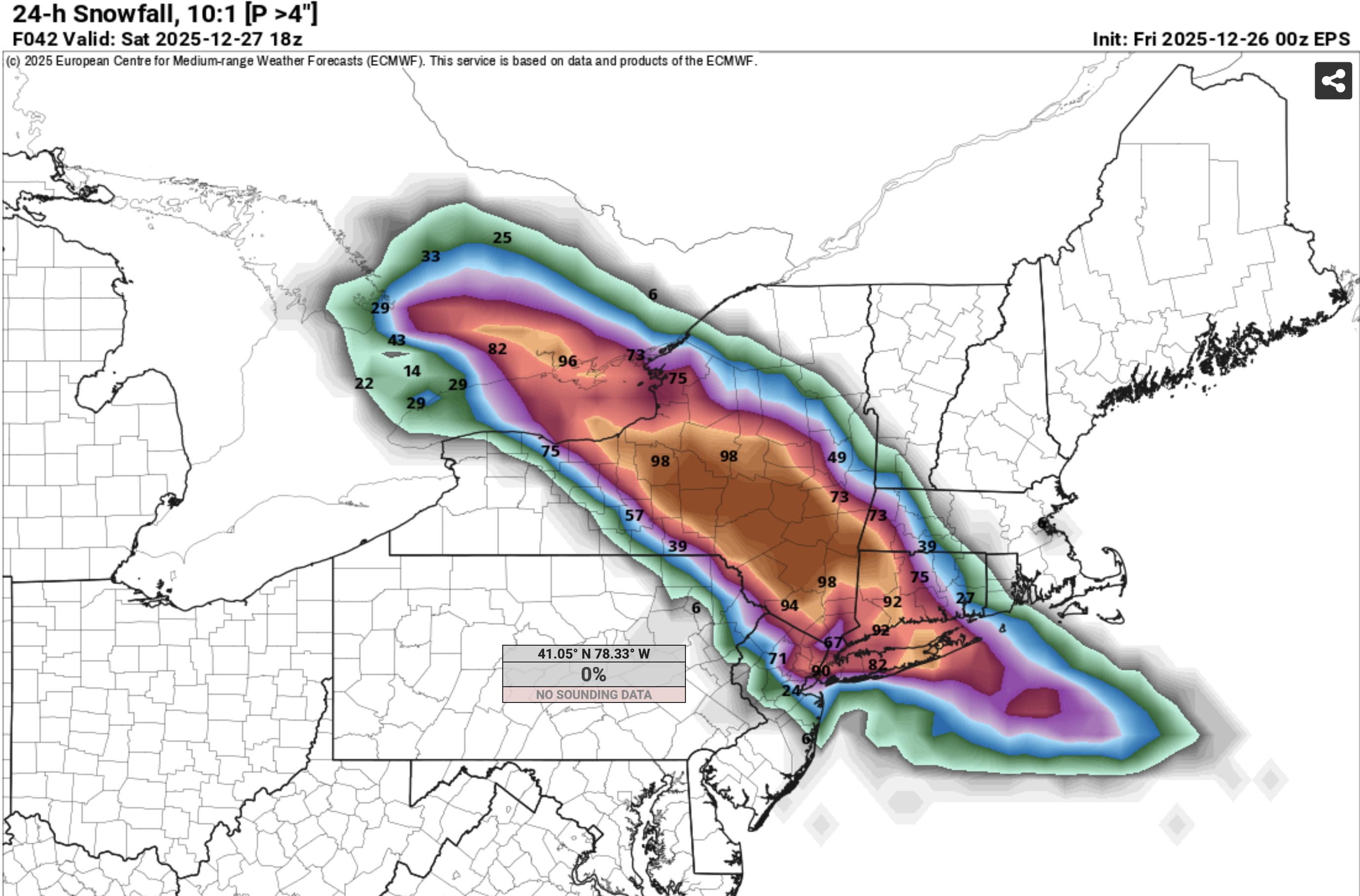
It reads the 9000 ft near 32F TT very well.... repeatedly. While NAM has lots of variability in its modeling of this storm... when you see it have ice, be cautious. Those that get my FB messages knew of my concern in NJ/PA. This is not a classic storm... no closed low at 850MB. Banding into good snow growth in the cold air produced. se NYS/CT/parts of LI. still a little hope for tail end southward rotate 1-2" down to I80 but the models overall were too snowy in ne PA/nw NJ including the SPC HREF big time. Euro prob for 4"+ seems pretty good. What I used this morning at 5s30A. Pattern still good for us into January. Good night.

-
I expressed my concern to OKX last weekend (the .02 T snow around daybreak. They kindly provided me their view using science soundings and what might have occurred. They prevailed on that T. I disagree but NWS prevails. It is obvious to me that improvement is needed in that CP snow reporting process. ALSO, that OKX send out a message that hits everyone at the same time with whatever occurred, instead of answering ph calls from media. NO ONE in the media deserves an advantage over another in the competitive media market. I've said my peace on this... I dealt with the same thing in NWS offices.
-
Classic winter snow event just ended with bitter cold to follow, similar to what I remember in the late 50s, 60s, 70s. Nice threading. I haven't been able to keep up with thread initiation, so am done threading and in general commenting. If you want a one way daily 6am ish message, dm me at [email protected] and let me know your location. Accuracy probably not as good as others in the D1-2 range but I know I grasp impacts ahead. I saw the Tomer Burg (polar weather) D1 post, after the event it was MUCH better than anything these I saw but I was also away in PA. I haven't done a very good job this year in nw NJ... partly due to aging slowing down and not able to review everything within constraints of home life. Am done considering what is posted on American Weather and also thread initiations, but I will add a precipitation total every once in a while. I'm at that age 75 where I need to focus much more here at home. Everyone continues on their own track. Best of health is what I think you will value. 12/14/25
-
00z/14 EPS melts most of the snow Wed-Fri AM, followed by potential wind advisory 45MPH gust event Friday afternoon-eve in CAA.
-
Wantage NJ 5.8" at 7A. Other Wanatge reports similar and similarly 5-6" from interior se PA through the ABE area to our area. Iso heavier totals. My last report. Blowing and drifting tonight with single digits or colder wind chill.
-
Wantage NJ 225AM 3.5". 28.9F light snow. It's a light weight powdery removal but slippery for sure.
-
Wantage NJ (this southern part at 740' MSL). 1.8" final-wet clingy snow. Less on driveway and virtually none on paved roads now... temp rising to 32.4F.
-
Wantage NJ (this southern part): 410 PM 1.2". The 3/4" or less driveway and 0.3" on salted road in front of our rural home, occasionally wet road there. 32.0F
-
Wantage 0.3" at 240P since SB around 150PM. 32.4aF down from a high of 35.2. We had sprinkles at 1025 AM. Driveway snow covered but treated roads just wet.
-
Nor did the observer at CP where 0.02 liquid occurring virtually as all snow and only T. Guessing the snow total was rounded down to a T (below 0.5"). That might be a future question mark for detail oriented minor climo checkers.
-
Who knows what goes on... I'll be interested in their 445P climates for LGA, EWR and CP and how a TV station got info before entire community regarding official amounts. That was always something that bothered me in offices, the TV station calls for info before the entire community. Competition.
-
Thank you Don. Clarification will eventually be needed.
-
Is there a message out on CP NON 0.1" snowfall this morning. I heard on CH4 it's a T? I can benefit from downsizing justification. Thanks.
-
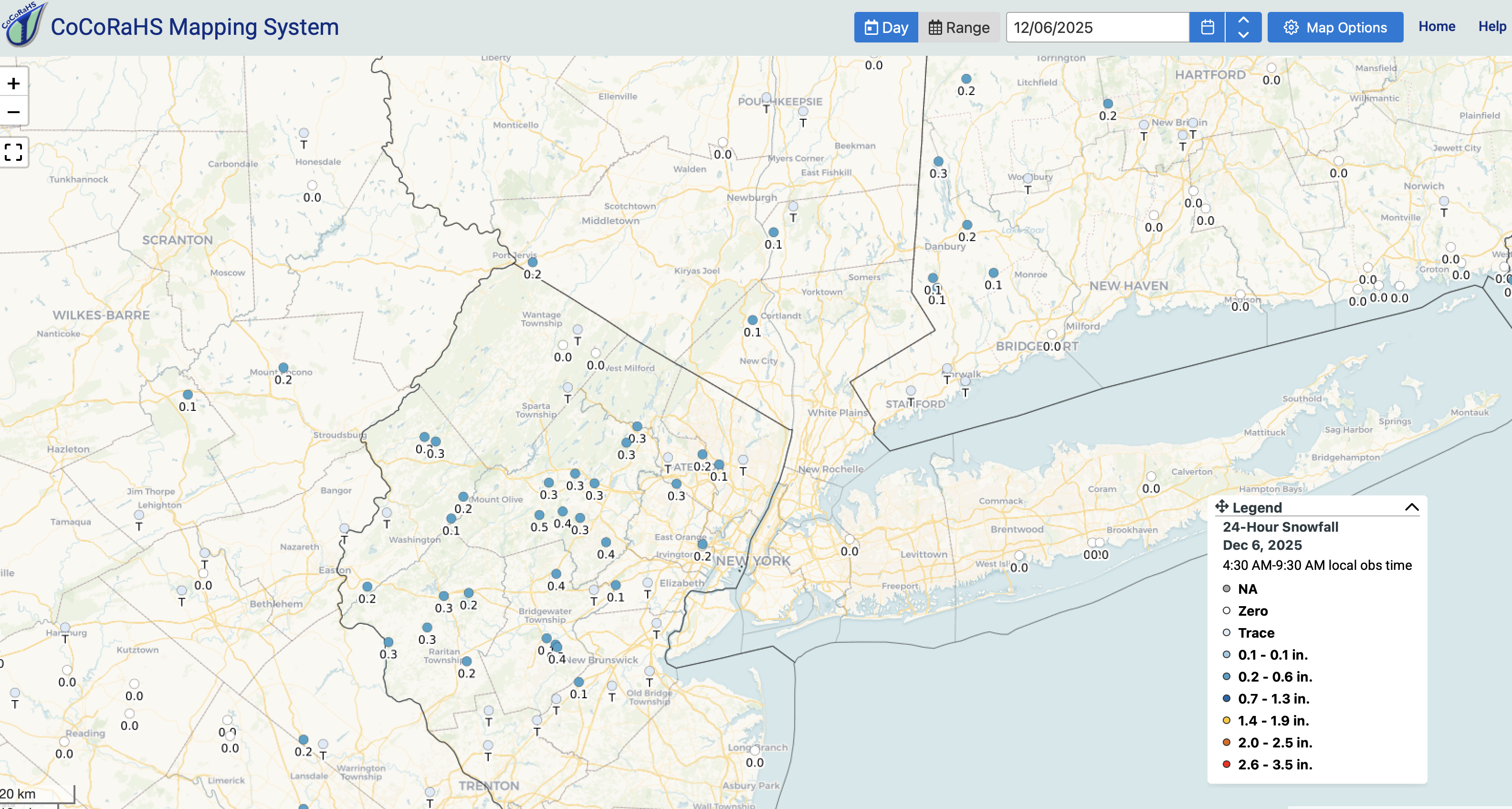
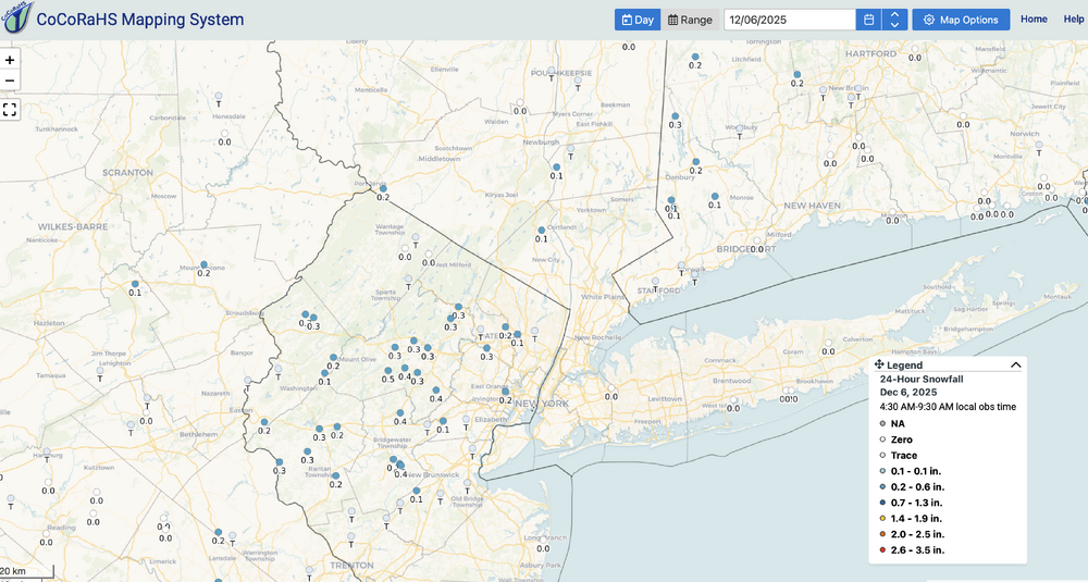
CoCoRaHs snowfall below as of 8A/6. Please click for clarity. Measurable snow sleet occurred at CP, KEWR, KLGA, a couple days earlier than POR normal first date in the second week of Dec. My last on this thread. We can move onto something bigger and more extensive inclusive of LI by the first day of winter (I would hope).
-
via XMACIS below. Newark POR 1931. normal first day of measurable snow 12/8 LaGuardia POR 1940. normal first day of measurable snow 12/11
-
KLGA and KEWR also measured this morning...both first of the season.