

donsutherland1
-
Posts
24,176 -
Joined
Content Type
Profiles
Blogs
Forums
American Weather
Media Demo
Store
Gallery
Everything posted by donsutherland1
-
February 2026 OBS & Discussion
donsutherland1 replied to Stormlover74's topic in New York City Metro
Here are the 16-day stretches with mean temperatures below 20° beginning with Winter 1975-76. I haven't added 2025-26, because the value isn't final, but it will come in between 19.7° and 19.9°.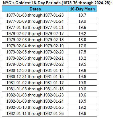
-
February 2026 OBS & Discussion
donsutherland1 replied to Stormlover74's topic in New York City Metro
January 24-February 8, 2026 is on track to record a 16-day mean temperature below 20° in Central Park. The last time that happened was outside the life span of many AmWx members: January 11-26, 1982. -
February 2026 OBS & Discussion
donsutherland1 replied to Stormlover74's topic in New York City Metro
Things change during the second half of February as wave lengths shorten. Since 1950, 75% of NYC's February 15 or later 10" or above snowstorms had a PNA-. -
February 2026 OBS & Discussion
donsutherland1 replied to Stormlover74's topic in New York City Metro
Some photos from this morning.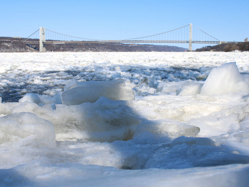


-
February 2026 OBS & Discussion
donsutherland1 replied to Stormlover74's topic in New York City Metro
Bridgeport, Central Park, Islip, JFK Airport, LaGuardia Airport, Newark, and White Plains have all registered daily low temperatures below 10° for the second consecutive day. The last time that occurred was January 30-31, 2019. -
February 2026 OBS & Discussion
donsutherland1 replied to Stormlover74's topic in New York City Metro
Yesterday’s high-low of 27-6 in NYC was a weathergami (only 27-6 combination in the climate record). -
February 2026 OBS & Discussion
donsutherland1 replied to Stormlover74's topic in New York City Metro
For the first time since February 4, 2023, Bridgeport, Central Park, Islip, JFK Airport, LaGuardia Airport, Newark, and White Plains have all registered daily low temperatures below 10°. Through 8 pm, the average low for the seven cities is 7.4°. On February 4, 2023, it was 2.9°. -
February 2026 OBS & Discussion
donsutherland1 replied to Stormlover74's topic in New York City Metro
You’d generally need a N or NNW wind. NYC doesn’t radiate very well. -
February 2026 OBS & Discussion
donsutherland1 replied to Stormlover74's topic in New York City Metro
The temperature in Central Park has fallen to 8°. That is New York City's coldest temperature since February 4, 2023 when the mercury dipped all the way to 3°. -
February 2026 OBS & Discussion
donsutherland1 replied to Stormlover74's topic in New York City Metro
The temperature in Central Park has fallen to 9°. That makes today the third day with a low below 10°. That's the most such days since Winter 2022-2023 when there were also three such days. -
February 2026 OBS & Discussion
donsutherland1 replied to Stormlover74's topic in New York City Metro
Bitterly cold air now covers the New York City region. As of 5 pm, the temperature in Central Park was just 10°. Tomorrow will likely be the coldest day this winter. The high temperature in New York City will be in the teens following a low in the middle to upper single digits. Monday will start very cold, but the afternoon will be less harsh as readings climb into the lower and middle 20s. The temperature will approach or reach freezing on Tuesday. The persistent and often severely cold pattern is poised to break near February 10th. However, exceptional warmth appears unlikely through at least mid-February, even as milder readings return. The ENSO Region 1+2 anomaly was +0.1°C and the Region 3.4 anomaly was -0.4°C for the week centered around January 28. For the past six weeks, the ENSO Region 1+2 anomaly has averaged -0.38°C and the ENSO Region 3.4 anomaly has averaged -0.57°C. La Niña conditions will likely continue into at least late winter. The SOI was -2.16 today. The preliminary Arctic Oscillation (AO) was -3.431 today. Based on sensitivity analysis applied to the latest guidance, there is an implied near 90% probability that New York City will have a cooler than normal February (1991-2020 normal). February will likely finish with a mean temperature near 31.0° (4.9° below normal). Supplemental Information: The projected mean would be 4.3° below the 1981-2010 normal monthly value. Overall, Winter 2025-2026 is on track for a seasonal mean temperature of 31.7°. That would be the lowest winter mean temperature since Winter 2014-2015 when the mean temperature was also 31.7°. Winter 2025-2026 would only become the fourth winter of the 21st century with a mean temperature of 32.0° or below. -
February 2026 OBS & Discussion
donsutherland1 replied to Stormlover74's topic in New York City Metro
Here's how things stand: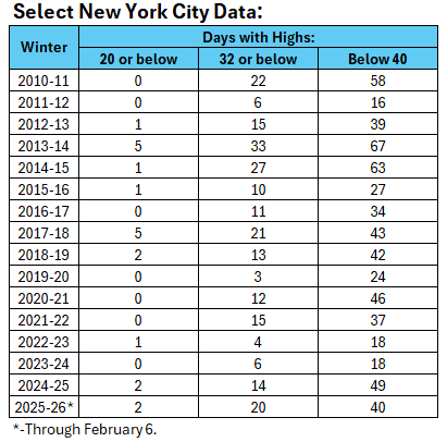
-
2025-2026 ENSO
donsutherland1 replied to 40/70 Benchmark's topic in Weather Forecasting and Discussion
It continues into the start of March. The Southeast could have the lowest chance of seeing a return to cold conditions. The Middle Atlantic could be a battleground. -
February 2026 OBS & Discussion
donsutherland1 replied to Stormlover74's topic in New York City Metro
Here’s BOX’s latest PNS: 715 NOUS41 KBOX 071830 PNSBOX CTZ002>004-MAZ002>024-026-RIZ001>008-080630- Public Information Statement National Weather Service Boston/Norton MA 130 PM EST Sat Feb 7 2026 ...SNOWFALL REPORTS... Location Amount Time/Date Provider ...Connecticut... ...Hartford County... Glastonbury Center 4.2 ENE 4.0 in 0900 AM 02/07 COCORAHS 1 SSE Marlborough 3.5 in 0842 AM 02/07 Trained Spotter Enfield 1.5 SE 2.5 in 0700 AM 02/07 COCORAHS Southwood Acres 0.3 WSW 2.5 in 0700 AM 02/07 COCORAHS Manchester 0.4 ENE 2.3 in 0730 AM 02/07 COCORAHS 1 SSW Vernon 2.3 in 0700 AM 02/07 COCORAHS Bristol 2.7 WNW 2.0 in 0700 AM 02/07 COCORAHS 1 ESE West Hartford 2.0 in 1030 AM 02/07 Amateur Radio 1 NNE Wethersfield 2.0 in 0930 AM 02/07 Amateur Radio Berlin 1.1 SE 1.8 in 0750 AM 02/07 COCORAHS Bloomfield 1.5 NW 1.7 in 0700 AM 02/07 COCORAHS West Hartford 0.5 ESE 1.4 in 0700 AM 02/07 COCORAHS Bradley AP 1.3 in 0100 PM 02/07 Official NWS Obs Southington 1.7 WNW 1.3 in 0800 AM 02/07 COCORAHS Suffield Depot 3.3 NNE 1.3 in 0700 AM 02/07 COCORAHS Newington 1.9 SSW 1.2 in 0700 AM 02/07 COCORAHS Salmon Brook 4.9 WSW 1.0 in 0700 AM 02/07 COCORAHS North Granby 1.3 ENE 0.8 in 0700 AM 02/07 COCORAHS ...Tolland County... Staffordville 5.0 in 0122 PM 02/07 CO-OP Observer 1 W Tolland 3.8 in 0948 AM 02/07 Tribal Leader Amston 1.7 N 3.5 in 0900 AM 02/07 COCORAHS Columbia 2.6 S 3.2 in 0830 AM 02/07 COCORAHS 4 S Tolland 3.0 in 1053 AM 02/07 Trained Spotter Vernon 1.6 N 2.6 in 0715 AM 02/07 COCORAHS Somersville 0.2 ENE 2.5 in 0745 AM 02/07 COCORAHS 1 NE Somers 2.2 in 0700 AM 02/07 COCORAHS Central Somers 0.3 N 2.0 in 0544 AM 02/07 COCORAHS ...Windham County... 3 ENE Killingly 8.0 in 1050 AM 02/07 Trained Spotter 1 ENE Killingly 7.0 in 1200 PM 02/07 Trained Spotter 3 SE Wauregan 7.0 in 1030 AM 02/07 Tribal Leader Canterbury 6.0 in 1035 AM 02/07 Amateur Radio Pomfret 4.5 in 0744 AM 02/07 Trained Spotter 2 E Danielson 4.0 in 0730 AM 02/07 COCORAHS Moosup 1.7 NE 3.5 in 0600 AM 02/07 COCORAHS 4 SW Union 3.5 in 0838 AM 02/07 Trained Spotter East Killingly 1.3 SW 2.0 in 0525 AM 02/07 COCORAHS Woodstock 2.0 in 0610 AM 02/07 Trained Spotter ...Massachusetts... ...Barnstable County... Falmouth 0.6 NNW 0.5 in 0800 AM 02/07 COCORAHS Mashpee 4.6 S 0.3 in 0800 AM 02/07 COCORAHS Waquoit 0.6 SSW 0.3 in 0800 AM 02/07 COCORAHS Barnstable 3.6 W 0.2 in 0700 AM 02/07 COCORAHS North Falmouth 1.0 NE 0.2 in 0800 AM 02/07 COCORAHS East Sandwich 0.1 in 0600 AM 02/07 COOP Brewster 1.4 W T in 0725 AM 02/07 COCORAHS Dennis 2.4 SE T in 0700 AM 02/07 COCORAHS East Falmouth 1.4 ESE T in 0745 AM 02/07 COCORAHS Osterville 1.6 NNW T in 0700 AM 02/07 COCORAHS Sandwich 0.9 NNE T in 0832 AM 02/07 COCORAHS South Dennis 1.0 NW T in 0700 AM 02/07 COCORAHS Truro 0.8 E T in 0630 AM 02/07 COCORAHS Yarmouth 2.0 S T in 0800 AM 02/07 COCORAHS ...Bristol County... NWS Boston/Norton 1.6 in 0100 PM 02/07 Official NWS Obs 2 NNE Bliss Corner 1.0 in 1200 PM 02/07 Amateur Radio Dighton 3.3 NNW 1.0 in 0700 AM 02/07 COCORAHS Fairhaven 2.2 ESE 1.0 in 0800 AM 02/07 COCORAHS 2 SSW Freetown 1.0 in 1000 AM 02/07 Public 1 SW North Attleborough 0.9 in 0741 AM 02/07 Trained Spotter Attleboro 0.9 ENE 0.8 in 0818 AM 02/07 COCORAHS Somerset 2.3 NNE 0.8 in 0700 AM 02/07 COCORAHS Rehoboth 2.1 N 0.7 in 0700 AM 02/07 COCORAHS Norton West 0.6 in 0700 AM 02/07 COOP Mansfield 2.4 ENE 0.5 in 0730 AM 02/07 COCORAHS Taunton 3.9 N 0.5 in 0730 AM 02/07 COCORAHS Acushnet 0.3 in 0600 AM 02/07 Amateur Radio 2 ESE New Bedford 0.3 in 0600 AM 02/07 Amateur Radio ...Dukes County... Vineyard Haven 0.8 WSW 0.8 in 0700 AM 02/07 COCORAHS Oak Bluffs 0.1 SW 0.5 in 0700 AM 02/07 COCORAHS West Tisbury 0.7 NNE 0.5 in 0700 AM 02/07 COCORAHS ...Essex County... Beverly Coop 13.0 in 0900 AM 02/07 COOP 2 SE Salisbury 13.0 in 1202 PM 02/07 Amateur Radio 2 W Manchester 11.7 in 0845 AM 02/07 COCORAHS Beverly 11.5 in 1045 AM 02/07 Trained Spotter 1 NNE Marblehead 11.5 in 0850 AM 02/07 Trained Spotter 1 ESE Danvers 10.8 in 1230 PM 02/07 Amateur Radio 2 WNW Gloucester 10.0 in 0102 PM 02/07 Trained Spotter Salem 10.0 in 0850 AM 02/07 Trained Spotter Hamilton 0.7 WSW 9.5 in 0730 AM 02/07 COCORAHS 2 NW Peabody 9.5 in 1200 PM 02/07 Amateur Radio Newburyport 8.5 in 1151 AM 02/07 Trained Spotter 2 N Saugus 6.5 in 1230 PM 02/07 Broadcast Media Rowley 6.2 in 0935 AM 02/07 Trained Spotter 1 WNW Ipswich 6.0 in 1035 AM 02/07 Trained Spotter Rockport 6.0 in 0955 AM 02/07 Trained Spotter 1 SE Lynn 5.8 in 0100 PM 02/07 Amateur Radio 1 N Methuen 5.5 in 1230 PM 02/07 Trained Spotter 3 W Haverhill 5.5 in 1220 PM 02/07 Trained Spotter 1 WNW Swampscott 5.0 in 1000 AM 02/07 Amateur Radio Boxford 1.8 WSW 4.5 in 0700 AM 02/07 COCORAHS 2 SE Amesbury 4.4 in 0110 PM 02/07 Trained Spotter 1 WNW Lynnfield 4.4 in 1013 AM 02/07 Trained Spotter Andover 4.0 in 1100 AM 02/07 Trained Spotter 1 SSE Haverhill 4.0 in 1115 AM 02/07 Amateur Radio 1 SSW North Andover 4.0 in 0901 AM 02/07 Amateur Radio Middleton 3.0 in 0700 AM 02/07 COOP Topsfield 3.0 in 0536 AM 02/07 Trained Spotter Groveland 1.2 NE 2.2 in 0915 AM 02/07 COCORAHS Andover 0.6 E 1.0 in 0633 AM 02/07 COCORAHS ...Franklin County... New Salem 3.1 S 3.3 in 0900 AM 02/07 COCORAHS 1 W Orange AP 2.5 in 0112 PM 02/07 Public 1 NW Turners Falls 2.5 in 0955 AM 02/07 Trained Spotter 3 NNW Greenfield 2.2 in 0951 AM 02/07 Public 1 WSW Ashfield 2.0 in 0800 AM 02/07 Amateur Radio East Hawley 1.6 in 0800 AM 02/07 COOP Conway 1.2 E 1.5 in 0700 AM 02/07 COCORAHS Shutesbury 2.9 SW 1.5 in 0700 AM 02/07 COCORAHS Sunderland 1.3 SE 1.5 in 0730 AM 02/07 COCORAHS Greenfield 1.4 in 0530 AM 02/07 COOP Colrain 3.7 WNW 1.3 in 0700 AM 02/07 COCORAHS Buckland 1.8 ESE 0.7 in 0730 AM 02/07 COCORAHS ...Hampden County... Hampden 2.0 NW 3.0 in 0800 AM 02/07 COCORAHS 1 SE Ludlow 2.5 in 0940 AM 02/07 Amateur Radio 3 WSW Springfield 2.5 in 0900 AM 02/07 Amateur Radio Holland 1.0 SSW 2.3 in 0700 AM 02/07 COCORAHS 2 SE West Springfield 1.5 in 0745 AM 02/07 Amateur Radio Feeding Hills 1.2 N 1.4 in 0700 AM 02/07 COCORAHS Agawam 1.1 SSW 1.0 in 0700 AM 02/07 COCORAHS 1 NNW Montgomery 1.0 in 0820 AM 02/07 Trained Spotter Russell 0.9 W 1.0 in 0700 AM 02/07 COCORAHS Southwick 4.3 NW 1.0 in 0700 AM 02/07 COCORAHS Westfield 2.2 N 1.0 in 0700 AM 02/07 COCORAHS ...Hampshire County... 1 WNW North Amherst 2.7 in 0918 AM 02/07 Trained Spotter Amherst 1.5 in 0715 AM 02/07 COOP South Hadley 3.2 SSW 1.2 in 0700 AM 02/07 COCORAHS Easthampton 1.0 E 1.1 in 0805 AM 02/07 COCORAHS Northampton 0.6 ESE 1.0 in 0700 AM 02/07 COCORAHS Plainfield 1.0 in 0805 AM 02/07 Trained Spotter Westhampton 0.4 WNW 1.0 in 0700 AM 02/07 COCORAHS Williamsburg 1.2 WSW 0.7 in 0610 AM 02/07 COCORAHS ...Middlesex County... 2 W Marlborough 6.8 in 1020 AM 02/07 Trained Spotter 1 E Winchester 5.0 in 1245 PM 02/07 Trained Spotter Ashby 4.0 in 1235 PM 02/07 Amateur Radio 3 NW Townsend 3.4 in 0107 PM 02/07 Trained Spotter 1 SSE Cochituate 3.0 in 0108 PM 02/07 Trained Spotter 1 NNW Lexington 2.6 in 1259 PM 02/07 Trained Spotter Natick 2.0 in 1130 AM 02/07 Public 1 WNW Pepperell 2.0 in 0802 AM 02/07 Trained Spotter Hudson 1.4 NW 1.7 in 0700 AM 02/07 COCORAHS Reading 1.2 N 1.7 in 0600 AM 02/07 COCORAHS Littleton 2.8 NNW 1.5 in 0700 AM 02/07 COCORAHS Lowell 2.6 ENE 1.4 in 0800 AM 02/07 COCORAHS Acton 1.3 SW 1.2 in 0700 AM 02/07 COCORAHS Ayer 0.1 SW 1.1 in 0700 AM 02/07 COCORAHS Melrose 1.0 WNW 1.1 in 0700 AM 02/07 COCORAHS Chelmsford 2.8 SSW 1.0 in 0737 AM 02/07 COCORAHS Framingham 2.0 NNE 1.0 in 0700 AM 02/07 COCORAHS Holliston 0.8 S 1.0 in 0700 AM 02/07 COCORAHS Maynard 0.7 ESE 1.0 in 0700 AM 02/07 COCORAHS Natick 1.9 NNE 1.0 in 0800 AM 02/07 COCORAHS Wilmington 2.2 WNW 1.0 in 0715 AM 02/07 COCORAHS 2 SE Carlisle 0.9 in 0710 AM 02/07 COCORAHS Medford 1.2 W 0.9 in 0700 AM 02/07 COCORAHS Watertown 1.1 W 0.8 in 0700 AM 02/07 COCORAHS ...Norfolk County... Bellingham 3.0 in 1215 PM 02/07 Trained Spotter 1 ESE Randolph 2.0 in 0121 PM 02/07 Trained Spotter Franklin 1.4 SW 1.0 in 0700 AM 02/07 COCORAHS Millis 1.0 in 0830 AM 02/07 Trained Spotter Blue Hill Coop 0.7 in 0700 AM 02/07 COOP Norfolk 1.6 WSW 0.6 in 0700 AM 02/07 COCORAHS Norwood 1.3 NW 0.6 in 0700 AM 02/07 COCORAHS Milton 1.3 N 0.5 in 0700 AM 02/07 COCORAHS South Weymouth 1.3 ENE 0.5 in 0930 AM 02/07 COCORAHS Westwood 1.5 SSW 0.5 in 0700 AM 02/07 COCORAHS Braintree 1.5 SE 0.2 in 0700 AM 02/07 COCORAHS ...Plymouth County... North Scituate 4.0 in 0118 PM 02/07 Trained Spotter Hingham 3.0 in 0100 PM 02/07 Amateur Radio 1 ESE Middleborough 2.4 in 1205 PM 02/07 Amateur Radio Rochester 1.0 in 0723 AM 02/07 COOP Abington 1.2 NNE 0.6 in 0700 AM 02/07 COCORAHS East Bridgewater 0.3 WSW 0.3 in 0700 AM 02/07 COCORAHS Marshfield 1.5 NNW 0.2 in 0700 AM 02/07 COCORAHS Carver 2.3 E 0.1 in 0600 AM 02/07 COCORAHS Kingston 3.3 WNW 0.1 in 0600 AM 02/07 COCORAHS Pembroke 2.8 SW 0.1 in 0800 AM 02/07 COCORAHS Plymouth 4.5 SSE T in 0652 AM 02/07 COCORAHS Wareham 5.6 NE T in 0700 AM 02/07 COCORAHS ...Suffolk County... 1 NE Beacon Hill 4.4 in 0100 PM 02/07 Trained Spotter Logan AP 4.2 in 0100 PM 02/07 Official NWS Obs South Boston 2.0 in 1200 PM 02/07 Amateur Radio Jamacia Plain 0.6 in 0800 AM 02/07 COOP ...Worcester County... 1 WNW Dudley 6.5 in 1100 AM 02/07 Trained Spotter 3 N Oxford 6.0 in 1154 AM 02/07 Public 3 ENE Charlton 5.8 in 1017 AM 02/07 Trained Spotter 2 WSW Ashburnham 5.2 in 1034 AM 02/07 Trained Spotter 1 SE Leicester 5.1 in 1232 PM 02/07 Trained Spotter 2 E Fitchburg 5.0 in 1159 AM 02/07 Trained Spotter Lunenburg 5.0 in 1155 AM 02/07 Trained Spotter Oxford 5.0 in 1230 PM 02/07 Trained Spotter Shrewsbury 5.0 in 1200 PM 02/07 Trained Spotter Worcester AP 4.9 in 0100 PM 02/07 Official NWS Obs 1 W Holden 4.5 in 1129 AM 02/07 Amateur Radio 1 S Southbridge 4.4 in 1130 AM 02/07 Amateur Radio 3 SW Auburn 4.3 in 1009 AM 02/07 Trained Spotter Grafton 4.0 in 1005 AM 02/07 Trained Spotter West Brookfield 4.0 in 1155 AM 02/07 Trained Spotter 1 NW Sturbridge 3.8 in 1000 AM 02/07 Trained Spotter Petersham 3.6 in 1150 AM 02/07 Trained Spotter 2 NNW Milford 3.5 in 1249 PM 02/07 Trained Spotter Spencer 1.7 W 2.9 in 0815 AM 02/07 COCORAHS Warren 2.4 WSW 2.5 in 0715 AM 02/07 COCORAHS Douglas 1.9 NNE 2.3 in 0730 AM 02/07 COCORAHS Boylston 1.5 S 2.0 in 0700 AM 02/07 COCORAHS Sterling 4.3 NW 2.0 in 0700 AM 02/07 COCORAHS Westminster 0.6 WSW 2.0 in 0643 AM 02/07 COCORAHS Barre 1.4 NNE 1.8 in 0700 AM 02/07 COCORAHS Berlin 1.3 WSW 1.8 in 0740 AM 02/07 COCORAHS Rutland 3.8 N 1.8 in 0700 AM 02/07 COCORAHS Athol 2.8 NNE 1.6 in 0730 AM 02/07 COCORAHS 2 SSE Hardwick 1.5 in 0530 AM 02/07 COCORAHS Uxbridge 2.4 WSW 1.2 in 0700 AM 02/07 COCORAHS Upton 1.0 in 0755 AM 02/07 Trained Spotter East Brimfield Lake 0.1 in 0700 AM 02/07 COOP ...Rhode Island... ...Bristol County... Barrington 1.8 NW 1.0 in 0815 AM 02/07 COCORAHS ...Kent County... 1 NNE Coventry 8.5 in 1200 PM 02/07 Amateur Radio 8 NW West Greenwich 7.0 in 0116 PM 02/07 Trained Spotter 1 NNW West Warwick 6.0 in 0120 PM 02/07 Trained Spotter Coventry 4.2 in 0900 AM 02/07 COCORAHS West Warwick 1.8 WNW 2.8 in 0700 AM 02/07 COCORAHS East Greenwich 2.3 ESE 2.7 in 0700 AM 02/07 COCORAHS 2 W Warwick 2.5 in 1000 AM 02/07 Amateur Radio TF Green AP 2.2 in 0100 PM 02/07 Official NWS Obs ...Newport County... Jamestown 0.3 SSE 3.0 in 0700 AM 02/07 COCORAHS Middletown 1.1 SW 2.0 in 0700 AM 02/07 COCORAHS Portsmouth 1.0 in 1000 AM 02/07 Amateur Radio Tiverton 4.4 SSE 0.6 in 0840 AM 02/07 COCORAHS ...Providence County... Harrisville 6.5 in 0106 PM 02/07 Public 2 SW Glocester 5.2 in 1245 PM 02/07 Trained Spotter 3 WSW Smithfield 5.2 in 0121 PM 02/07 Trained Spotter 1 SSE North Providence 3.5 in 0108 PM 02/07 Public 1 SSE Cumberland 2.7 in 0115 PM 02/07 NWS Employee 2 ENE Providence 2.7 in 0100 PM 02/07 Public 1 SSW Smithfield 2.5 in 1000 AM 02/07 Amateur Radio Greenville 6.7 WSW 2.3 in 0700 AM 02/07 COCORAHS Pascoag 0.5 SSW 1.9 in 0700 AM 02/07 COCORAHS North Smithfield 0.7 SE 1.0 in 0700 AM 02/07 COCORAHS Pawtucket 2.6 SSE 0.8 in 0700 AM 02/07 COCORAHS East Providence 2.6 N 0.7 in 0700 AM 02/07 COCORAHS ...Washington County... 2 NE South Kingstown 9.8 in 1150 AM 02/07 Trained Spotter 3 SE Ashaway 9.5 in 1100 AM 02/07 Amateur Radio 1 NNE Hopkinton 9.0 in 1000 AM 02/07 Amateur Radio 2 NW Westerly 9.0 in 1056 AM 02/07 Public Kingston 0.7 WSW 8.4 in 0700 AM 02/07 COCORAHS 1 SSE North Kingstown 8.0 in 1200 PM 02/07 Amateur Radio 1 W Richmond 8.0 in 0830 AM 02/07 Trained Spotter 1 WNW Westerly 8.0 in 1200 PM 02/07 Amateur Radio Charlestown 3.0 WSW 7.0 in 0800 AM 02/07 COCORAHS 3 WNW Jamestown 7.0 in 1015 AM 02/07 Amateur Radio 2 WNW Narragansett 7.0 in 1027 AM 02/07 Trained Spotter Hope Valley 1.1 NW 6.0 in 0800 AM 02/07 COCORAHS 2 NNE Block Island 5.0 in 0820 AM 02/07 Public Saunderstown 1.4 SW 4.0 in 0740 AM 02/07 COCORAHS Block Island Coop 3.0 in 0800 AM 02/07 COOP && -
Friday February 6 FROPA / WINDEX small event
donsutherland1 replied to HoarfrostHubb's topic in New England
715 NOUS41 KBOX 071830 PNSBOX CTZ002>004-MAZ002>024-026-RIZ001>008-080630- Public Information Statement National Weather Service Boston/Norton MA 130 PM EST Sat Feb 7 2026 ...SNOWFALL REPORTS... Location Amount Time/Date Provider ...Connecticut... ...Hartford County... Glastonbury Center 4.2 ENE 4.0 in 0900 AM 02/07 COCORAHS 1 SSE Marlborough 3.5 in 0842 AM 02/07 Trained Spotter Enfield 1.5 SE 2.5 in 0700 AM 02/07 COCORAHS Southwood Acres 0.3 WSW 2.5 in 0700 AM 02/07 COCORAHS Manchester 0.4 ENE 2.3 in 0730 AM 02/07 COCORAHS 1 SSW Vernon 2.3 in 0700 AM 02/07 COCORAHS Bristol 2.7 WNW 2.0 in 0700 AM 02/07 COCORAHS 1 ESE West Hartford 2.0 in 1030 AM 02/07 Amateur Radio 1 NNE Wethersfield 2.0 in 0930 AM 02/07 Amateur Radio Berlin 1.1 SE 1.8 in 0750 AM 02/07 COCORAHS Bloomfield 1.5 NW 1.7 in 0700 AM 02/07 COCORAHS West Hartford 0.5 ESE 1.4 in 0700 AM 02/07 COCORAHS Bradley AP 1.3 in 0100 PM 02/07 Official NWS Obs Southington 1.7 WNW 1.3 in 0800 AM 02/07 COCORAHS Suffield Depot 3.3 NNE 1.3 in 0700 AM 02/07 COCORAHS Newington 1.9 SSW 1.2 in 0700 AM 02/07 COCORAHS Salmon Brook 4.9 WSW 1.0 in 0700 AM 02/07 COCORAHS North Granby 1.3 ENE 0.8 in 0700 AM 02/07 COCORAHS ...Tolland County... Staffordville 5.0 in 0122 PM 02/07 CO-OP Observer 1 W Tolland 3.8 in 0948 AM 02/07 Tribal Leader Amston 1.7 N 3.5 in 0900 AM 02/07 COCORAHS Columbia 2.6 S 3.2 in 0830 AM 02/07 COCORAHS 4 S Tolland 3.0 in 1053 AM 02/07 Trained Spotter Vernon 1.6 N 2.6 in 0715 AM 02/07 COCORAHS Somersville 0.2 ENE 2.5 in 0745 AM 02/07 COCORAHS 1 NE Somers 2.2 in 0700 AM 02/07 COCORAHS Central Somers 0.3 N 2.0 in 0544 AM 02/07 COCORAHS ...Windham County... 3 ENE Killingly 8.0 in 1050 AM 02/07 Trained Spotter 1 ENE Killingly 7.0 in 1200 PM 02/07 Trained Spotter 3 SE Wauregan 7.0 in 1030 AM 02/07 Tribal Leader Canterbury 6.0 in 1035 AM 02/07 Amateur Radio Pomfret 4.5 in 0744 AM 02/07 Trained Spotter 2 E Danielson 4.0 in 0730 AM 02/07 COCORAHS Moosup 1.7 NE 3.5 in 0600 AM 02/07 COCORAHS 4 SW Union 3.5 in 0838 AM 02/07 Trained Spotter East Killingly 1.3 SW 2.0 in 0525 AM 02/07 COCORAHS Woodstock 2.0 in 0610 AM 02/07 Trained Spotter ...Massachusetts... ...Barnstable County... Falmouth 0.6 NNW 0.5 in 0800 AM 02/07 COCORAHS Mashpee 4.6 S 0.3 in 0800 AM 02/07 COCORAHS Waquoit 0.6 SSW 0.3 in 0800 AM 02/07 COCORAHS Barnstable 3.6 W 0.2 in 0700 AM 02/07 COCORAHS North Falmouth 1.0 NE 0.2 in 0800 AM 02/07 COCORAHS East Sandwich 0.1 in 0600 AM 02/07 COOP Brewster 1.4 W T in 0725 AM 02/07 COCORAHS Dennis 2.4 SE T in 0700 AM 02/07 COCORAHS East Falmouth 1.4 ESE T in 0745 AM 02/07 COCORAHS Osterville 1.6 NNW T in 0700 AM 02/07 COCORAHS Sandwich 0.9 NNE T in 0832 AM 02/07 COCORAHS South Dennis 1.0 NW T in 0700 AM 02/07 COCORAHS Truro 0.8 E T in 0630 AM 02/07 COCORAHS Yarmouth 2.0 S T in 0800 AM 02/07 COCORAHS ...Bristol County... NWS Boston/Norton 1.6 in 0100 PM 02/07 Official NWS Obs 2 NNE Bliss Corner 1.0 in 1200 PM 02/07 Amateur Radio Dighton 3.3 NNW 1.0 in 0700 AM 02/07 COCORAHS Fairhaven 2.2 ESE 1.0 in 0800 AM 02/07 COCORAHS 2 SSW Freetown 1.0 in 1000 AM 02/07 Public 1 SW North Attleborough 0.9 in 0741 AM 02/07 Trained Spotter Attleboro 0.9 ENE 0.8 in 0818 AM 02/07 COCORAHS Somerset 2.3 NNE 0.8 in 0700 AM 02/07 COCORAHS Rehoboth 2.1 N 0.7 in 0700 AM 02/07 COCORAHS Norton West 0.6 in 0700 AM 02/07 COOP Mansfield 2.4 ENE 0.5 in 0730 AM 02/07 COCORAHS Taunton 3.9 N 0.5 in 0730 AM 02/07 COCORAHS Acushnet 0.3 in 0600 AM 02/07 Amateur Radio 2 ESE New Bedford 0.3 in 0600 AM 02/07 Amateur Radio ...Dukes County... Vineyard Haven 0.8 WSW 0.8 in 0700 AM 02/07 COCORAHS Oak Bluffs 0.1 SW 0.5 in 0700 AM 02/07 COCORAHS West Tisbury 0.7 NNE 0.5 in 0700 AM 02/07 COCORAHS ...Essex County... Beverly Coop 13.0 in 0900 AM 02/07 COOP 2 SE Salisbury 13.0 in 1202 PM 02/07 Amateur Radio 2 W Manchester 11.7 in 0845 AM 02/07 COCORAHS Beverly 11.5 in 1045 AM 02/07 Trained Spotter 1 NNE Marblehead 11.5 in 0850 AM 02/07 Trained Spotter 1 ESE Danvers 10.8 in 1230 PM 02/07 Amateur Radio 2 WNW Gloucester 10.0 in 0102 PM 02/07 Trained Spotter Salem 10.0 in 0850 AM 02/07 Trained Spotter Hamilton 0.7 WSW 9.5 in 0730 AM 02/07 COCORAHS 2 NW Peabody 9.5 in 1200 PM 02/07 Amateur Radio Newburyport 8.5 in 1151 AM 02/07 Trained Spotter 2 N Saugus 6.5 in 1230 PM 02/07 Broadcast Media Rowley 6.2 in 0935 AM 02/07 Trained Spotter 1 WNW Ipswich 6.0 in 1035 AM 02/07 Trained Spotter Rockport 6.0 in 0955 AM 02/07 Trained Spotter 1 SE Lynn 5.8 in 0100 PM 02/07 Amateur Radio 1 N Methuen 5.5 in 1230 PM 02/07 Trained Spotter 3 W Haverhill 5.5 in 1220 PM 02/07 Trained Spotter 1 WNW Swampscott 5.0 in 1000 AM 02/07 Amateur Radio Boxford 1.8 WSW 4.5 in 0700 AM 02/07 COCORAHS 2 SE Amesbury 4.4 in 0110 PM 02/07 Trained Spotter 1 WNW Lynnfield 4.4 in 1013 AM 02/07 Trained Spotter Andover 4.0 in 1100 AM 02/07 Trained Spotter 1 SSE Haverhill 4.0 in 1115 AM 02/07 Amateur Radio 1 SSW North Andover 4.0 in 0901 AM 02/07 Amateur Radio Middleton 3.0 in 0700 AM 02/07 COOP Topsfield 3.0 in 0536 AM 02/07 Trained Spotter Groveland 1.2 NE 2.2 in 0915 AM 02/07 COCORAHS Andover 0.6 E 1.0 in 0633 AM 02/07 COCORAHS ...Franklin County... New Salem 3.1 S 3.3 in 0900 AM 02/07 COCORAHS 1 W Orange AP 2.5 in 0112 PM 02/07 Public 1 NW Turners Falls 2.5 in 0955 AM 02/07 Trained Spotter 3 NNW Greenfield 2.2 in 0951 AM 02/07 Public 1 WSW Ashfield 2.0 in 0800 AM 02/07 Amateur Radio East Hawley 1.6 in 0800 AM 02/07 COOP Conway 1.2 E 1.5 in 0700 AM 02/07 COCORAHS Shutesbury 2.9 SW 1.5 in 0700 AM 02/07 COCORAHS Sunderland 1.3 SE 1.5 in 0730 AM 02/07 COCORAHS Greenfield 1.4 in 0530 AM 02/07 COOP Colrain 3.7 WNW 1.3 in 0700 AM 02/07 COCORAHS Buckland 1.8 ESE 0.7 in 0730 AM 02/07 COCORAHS ...Hampden County... Hampden 2.0 NW 3.0 in 0800 AM 02/07 COCORAHS 1 SE Ludlow 2.5 in 0940 AM 02/07 Amateur Radio 3 WSW Springfield 2.5 in 0900 AM 02/07 Amateur Radio Holland 1.0 SSW 2.3 in 0700 AM 02/07 COCORAHS 2 SE West Springfield 1.5 in 0745 AM 02/07 Amateur Radio Feeding Hills 1.2 N 1.4 in 0700 AM 02/07 COCORAHS Agawam 1.1 SSW 1.0 in 0700 AM 02/07 COCORAHS 1 NNW Montgomery 1.0 in 0820 AM 02/07 Trained Spotter Russell 0.9 W 1.0 in 0700 AM 02/07 COCORAHS Southwick 4.3 NW 1.0 in 0700 AM 02/07 COCORAHS Westfield 2.2 N 1.0 in 0700 AM 02/07 COCORAHS ...Hampshire County... 1 WNW North Amherst 2.7 in 0918 AM 02/07 Trained Spotter Amherst 1.5 in 0715 AM 02/07 COOP South Hadley 3.2 SSW 1.2 in 0700 AM 02/07 COCORAHS Easthampton 1.0 E 1.1 in 0805 AM 02/07 COCORAHS Northampton 0.6 ESE 1.0 in 0700 AM 02/07 COCORAHS Plainfield 1.0 in 0805 AM 02/07 Trained Spotter Westhampton 0.4 WNW 1.0 in 0700 AM 02/07 COCORAHS Williamsburg 1.2 WSW 0.7 in 0610 AM 02/07 COCORAHS ...Middlesex County... 2 W Marlborough 6.8 in 1020 AM 02/07 Trained Spotter 1 E Winchester 5.0 in 1245 PM 02/07 Trained Spotter Ashby 4.0 in 1235 PM 02/07 Amateur Radio 3 NW Townsend 3.4 in 0107 PM 02/07 Trained Spotter 1 SSE Cochituate 3.0 in 0108 PM 02/07 Trained Spotter 1 NNW Lexington 2.6 in 1259 PM 02/07 Trained Spotter Natick 2.0 in 1130 AM 02/07 Public 1 WNW Pepperell 2.0 in 0802 AM 02/07 Trained Spotter Hudson 1.4 NW 1.7 in 0700 AM 02/07 COCORAHS Reading 1.2 N 1.7 in 0600 AM 02/07 COCORAHS Littleton 2.8 NNW 1.5 in 0700 AM 02/07 COCORAHS Lowell 2.6 ENE 1.4 in 0800 AM 02/07 COCORAHS Acton 1.3 SW 1.2 in 0700 AM 02/07 COCORAHS Ayer 0.1 SW 1.1 in 0700 AM 02/07 COCORAHS Melrose 1.0 WNW 1.1 in 0700 AM 02/07 COCORAHS Chelmsford 2.8 SSW 1.0 in 0737 AM 02/07 COCORAHS Framingham 2.0 NNE 1.0 in 0700 AM 02/07 COCORAHS Holliston 0.8 S 1.0 in 0700 AM 02/07 COCORAHS Maynard 0.7 ESE 1.0 in 0700 AM 02/07 COCORAHS Natick 1.9 NNE 1.0 in 0800 AM 02/07 COCORAHS Wilmington 2.2 WNW 1.0 in 0715 AM 02/07 COCORAHS 2 SE Carlisle 0.9 in 0710 AM 02/07 COCORAHS Medford 1.2 W 0.9 in 0700 AM 02/07 COCORAHS Watertown 1.1 W 0.8 in 0700 AM 02/07 COCORAHS ...Norfolk County... Bellingham 3.0 in 1215 PM 02/07 Trained Spotter 1 ESE Randolph 2.0 in 0121 PM 02/07 Trained Spotter Franklin 1.4 SW 1.0 in 0700 AM 02/07 COCORAHS Millis 1.0 in 0830 AM 02/07 Trained Spotter Blue Hill Coop 0.7 in 0700 AM 02/07 COOP Norfolk 1.6 WSW 0.6 in 0700 AM 02/07 COCORAHS Norwood 1.3 NW 0.6 in 0700 AM 02/07 COCORAHS Milton 1.3 N 0.5 in 0700 AM 02/07 COCORAHS South Weymouth 1.3 ENE 0.5 in 0930 AM 02/07 COCORAHS Westwood 1.5 SSW 0.5 in 0700 AM 02/07 COCORAHS Braintree 1.5 SE 0.2 in 0700 AM 02/07 COCORAHS ...Plymouth County... North Scituate 4.0 in 0118 PM 02/07 Trained Spotter Hingham 3.0 in 0100 PM 02/07 Amateur Radio 1 ESE Middleborough 2.4 in 1205 PM 02/07 Amateur Radio Rochester 1.0 in 0723 AM 02/07 COOP Abington 1.2 NNE 0.6 in 0700 AM 02/07 COCORAHS East Bridgewater 0.3 WSW 0.3 in 0700 AM 02/07 COCORAHS Marshfield 1.5 NNW 0.2 in 0700 AM 02/07 COCORAHS Carver 2.3 E 0.1 in 0600 AM 02/07 COCORAHS Kingston 3.3 WNW 0.1 in 0600 AM 02/07 COCORAHS Pembroke 2.8 SW 0.1 in 0800 AM 02/07 COCORAHS Plymouth 4.5 SSE T in 0652 AM 02/07 COCORAHS Wareham 5.6 NE T in 0700 AM 02/07 COCORAHS ...Suffolk County... 1 NE Beacon Hill 4.4 in 0100 PM 02/07 Trained Spotter Logan AP 4.2 in 0100 PM 02/07 Official NWS Obs South Boston 2.0 in 1200 PM 02/07 Amateur Radio Jamacia Plain 0.6 in 0800 AM 02/07 COOP ...Worcester County... 1 WNW Dudley 6.5 in 1100 AM 02/07 Trained Spotter 3 N Oxford 6.0 in 1154 AM 02/07 Public 3 ENE Charlton 5.8 in 1017 AM 02/07 Trained Spotter 2 WSW Ashburnham 5.2 in 1034 AM 02/07 Trained Spotter 1 SE Leicester 5.1 in 1232 PM 02/07 Trained Spotter 2 E Fitchburg 5.0 in 1159 AM 02/07 Trained Spotter Lunenburg 5.0 in 1155 AM 02/07 Trained Spotter Oxford 5.0 in 1230 PM 02/07 Trained Spotter Shrewsbury 5.0 in 1200 PM 02/07 Trained Spotter Worcester AP 4.9 in 0100 PM 02/07 Official NWS Obs 1 W Holden 4.5 in 1129 AM 02/07 Amateur Radio 1 S Southbridge 4.4 in 1130 AM 02/07 Amateur Radio 3 SW Auburn 4.3 in 1009 AM 02/07 Trained Spotter Grafton 4.0 in 1005 AM 02/07 Trained Spotter West Brookfield 4.0 in 1155 AM 02/07 Trained Spotter 1 NW Sturbridge 3.8 in 1000 AM 02/07 Trained Spotter Petersham 3.6 in 1150 AM 02/07 Trained Spotter 2 NNW Milford 3.5 in 1249 PM 02/07 Trained Spotter Spencer 1.7 W 2.9 in 0815 AM 02/07 COCORAHS Warren 2.4 WSW 2.5 in 0715 AM 02/07 COCORAHS Douglas 1.9 NNE 2.3 in 0730 AM 02/07 COCORAHS Boylston 1.5 S 2.0 in 0700 AM 02/07 COCORAHS Sterling 4.3 NW 2.0 in 0700 AM 02/07 COCORAHS Westminster 0.6 WSW 2.0 in 0643 AM 02/07 COCORAHS Barre 1.4 NNE 1.8 in 0700 AM 02/07 COCORAHS Berlin 1.3 WSW 1.8 in 0740 AM 02/07 COCORAHS Rutland 3.8 N 1.8 in 0700 AM 02/07 COCORAHS Athol 2.8 NNE 1.6 in 0730 AM 02/07 COCORAHS 2 SSE Hardwick 1.5 in 0530 AM 02/07 COCORAHS Uxbridge 2.4 WSW 1.2 in 0700 AM 02/07 COCORAHS Upton 1.0 in 0755 AM 02/07 Trained Spotter East Brimfield Lake 0.1 in 0700 AM 02/07 COOP ...Rhode Island... ...Bristol County... Barrington 1.8 NW 1.0 in 0815 AM 02/07 COCORAHS ...Kent County... 1 NNE Coventry 8.5 in 1200 PM 02/07 Amateur Radio 8 NW West Greenwich 7.0 in 0116 PM 02/07 Trained Spotter 1 NNW West Warwick 6.0 in 0120 PM 02/07 Trained Spotter Coventry 4.2 in 0900 AM 02/07 COCORAHS West Warwick 1.8 WNW 2.8 in 0700 AM 02/07 COCORAHS East Greenwich 2.3 ESE 2.7 in 0700 AM 02/07 COCORAHS 2 W Warwick 2.5 in 1000 AM 02/07 Amateur Radio TF Green AP 2.2 in 0100 PM 02/07 Official NWS Obs ...Newport County... Jamestown 0.3 SSE 3.0 in 0700 AM 02/07 COCORAHS Middletown 1.1 SW 2.0 in 0700 AM 02/07 COCORAHS Portsmouth 1.0 in 1000 AM 02/07 Amateur Radio Tiverton 4.4 SSE 0.6 in 0840 AM 02/07 COCORAHS ...Providence County... Harrisville 6.5 in 0106 PM 02/07 Public 2 SW Glocester 5.2 in 1245 PM 02/07 Trained Spotter 3 WSW Smithfield 5.2 in 0121 PM 02/07 Trained Spotter 1 SSE North Providence 3.5 in 0108 PM 02/07 Public 1 SSE Cumberland 2.7 in 0115 PM 02/07 NWS Employee 2 ENE Providence 2.7 in 0100 PM 02/07 Public 1 SSW Smithfield 2.5 in 1000 AM 02/07 Amateur Radio Greenville 6.7 WSW 2.3 in 0700 AM 02/07 COCORAHS Pascoag 0.5 SSW 1.9 in 0700 AM 02/07 COCORAHS North Smithfield 0.7 SE 1.0 in 0700 AM 02/07 COCORAHS Pawtucket 2.6 SSE 0.8 in 0700 AM 02/07 COCORAHS East Providence 2.6 N 0.7 in 0700 AM 02/07 COCORAHS ...Washington County... 2 NE South Kingstown 9.8 in 1150 AM 02/07 Trained Spotter 3 SE Ashaway 9.5 in 1100 AM 02/07 Amateur Radio 1 NNE Hopkinton 9.0 in 1000 AM 02/07 Amateur Radio 2 NW Westerly 9.0 in 1056 AM 02/07 Public Kingston 0.7 WSW 8.4 in 0700 AM 02/07 COCORAHS 1 SSE North Kingstown 8.0 in 1200 PM 02/07 Amateur Radio 1 W Richmond 8.0 in 0830 AM 02/07 Trained Spotter 1 WNW Westerly 8.0 in 1200 PM 02/07 Amateur Radio Charlestown 3.0 WSW 7.0 in 0800 AM 02/07 COCORAHS 3 WNW Jamestown 7.0 in 1015 AM 02/07 Amateur Radio 2 WNW Narragansett 7.0 in 1027 AM 02/07 Trained Spotter Hope Valley 1.1 NW 6.0 in 0800 AM 02/07 COCORAHS 2 NNE Block Island 5.0 in 0820 AM 02/07 Public Saunderstown 1.4 SW 4.0 in 0740 AM 02/07 COCORAHS Block Island Coop 3.0 in 0800 AM 02/07 COOP && -
Christina Georgina Rossetti's "In the Bleak Midwinter" opens: ...frosty wind made moan, earth stood hard as iron, water like a stone; snow had fallen, snow on snow, snow on snow... Today presents a scene that could have been taken right from that poem. An icy wind frequently gusting past 40 mph hurls the powder of last night's light snowfall all about. Occasional gusts propel the snow into dense clouds. Periodically, flurries fall from a slate gray sky that dims a feeble sun. The thermometer quietly slips ever lower through the teens. Overall, today has exceptional wintry appeal. Even as the New York City area is not experiencing the near blizzard conditions that have gripped New England's Cape Ann, the day is one that can be savored by all who cherish the winter, its cold, and its snow. To those who embrace winter and everything it has to offer, there is nothing "bleak" about winter. Finally, the dreadful dearth of such days in recent years makes today feel even more special.
-
February 2026 OBS & Discussion
donsutherland1 replied to Stormlover74's topic in New York City Metro
181 NOUS41 KOKX 071525 PNSOKX CTZ005>012-NJZ002-004-006-103>108-NYZ067>075-078>081-176>179-080325- Public Information Statement National Weather Service New York NY 1025 AM EST Sat Feb 7 2026 ...SNOWFALL REPORTS... Location Amount Time/Date Provider ...Connecticut... ...Fairfield County... 3 WSW Shelton 1.6 in 0850 AM 02/07 Trained Spotter Shelton 1.6 in 0850 AM 02/07 COCORAHS New Canaan 1.5 in 0800 AM 02/07 COCORAHS Sherman 1.2 E 1.5 in 0700 AM 02/07 COCORAHS Ridgefield 2.4 NNE 1.4 in 0700 AM 02/07 COCORAHS Bethel 1.2 in 0855 AM 02/07 COCORAHS Norwalk 1.2 in 0700 AM 02/07 COCORAHS Bethel 1.0 in 0700 AM 02/07 COCORAHS Bethel 4.5 SSE 1.0 in 0700 AM 02/07 COCORAHS Stamford 1.0 S 1.0 in 0700 AM 02/07 COCORAHS Bridgeport Airport 0.7 in 0700 AM 02/07 Official NWS Obs Norwalk 0.7 in 0800 AM 02/07 COCORAHS Stratford 0.5 in 0700 AM 02/07 COCORAHS ...Middlesex County... Durham 3.0 in 0700 AM 02/07 COCORAHS Higganum 3.0 in 0800 AM 02/07 COCORAHS Killingworth 2.0 in 0700 AM 02/07 COCORAHS Middlefield 1.4 W 2.0 in 0600 AM 02/07 COCORAHS 1 ESE Middletown 2.0 in 0950 AM 02/07 Trained Spotter Old Saybrook 2.9 NNE 1.9 in 0723 AM 02/07 COCORAHS ...New Haven County... Madison 3.5 in 0826 AM 02/07 Trained Spotter Guilford 3.2 in 0944 AM 02/07 CO-OP Observer 3 ENE Branford 2.0 in 0955 AM 02/07 Public Madison Center 1.3 N 1.7 in 0700 AM 02/07 COCORAHS 1 WNW North Haven 1.5 in 0854 AM 02/07 Trained Spotter Yalesville 1.5 in 0815 AM 02/07 COCORAHS Prospect 1.4 in 0730 AM 02/07 COCORAHS Hamden 1.1 in 0700 AM 02/07 COCORAHS Waterbury 1.0 in 0700 AM 02/07 COCORAHS ...New London County... Ledyard Center 6.4 in 0930 AM 02/07 Public 1 ENE Jewett City 6.0 in 0932 AM 02/07 Public Preston 5.7 in 0955 AM 02/07 Public 2 ENE Ledyard Center 5.0 in 0932 AM 02/07 Trained Spotter Mystic 5.0 in 0916 AM 02/07 Public Norwich 4.1 in 0900 AM 02/07 Cocorahs 2 NE Ledyard Center 4.0 in 0825 AM 02/07 Trained Spotter Norwich 5.2 SE 3.8 in 0700 AM 02/07 COCORAHS Mystic 3.6 in 0700 AM 02/07 COCORAHS Preston 3.6 in 0730 AM 02/07 COCORAHS New London 3.5 in 0730 AM 02/07 COCORAHS 1 SSW New London 3.5 in 0744 AM 02/07 Cocorahs Mystic 3.3 in 0700 AM 02/07 COCORAHS Groton 3.0 in 0700 AM 02/07 COCORAHS Norwich 3.0 in 0700 AM 02/07 COOP Norwich 2.6 in 0600 AM 02/07 COCORAHS East Lyme 2.5 in 0600 AM 02/07 COCORAHS Waterford 2.3 in 0700 AM 02/07 COCORAHS Niantic 2.0 in 0430 AM 02/07 COCORAHS Old Lyme 1.7 NNE 2.0 in 0700 AM 02/07 COCORAHS ...New Jersey... ...Bergen County... Montvale 1.8 ESE 0.4 in 0800 AM 02/07 COCORAHS Oakland 0.3 in 0800 AM 02/07 COCORAHS Fair Lawn 0.1 in 0830 AM 02/07 COCORAHS Tenafly 0.1 in 0730 AM 02/07 COCORAHS ...Essex County... West Orange Twp 0.6 WNW 0.4 in 0700 AM 02/07 COCORAHS ...Hudson County... Harrison 0.1 in 0614 AM 02/07 CO-OP Observer ...Passaic County... Little Falls 0.2 in 0700 AM 02/07 COCORAHS ...Union County... New Providence 0.2 in 0730 AM 02/07 COCORAHS Newark Airport 0.1 in 0700 AM 02/07 Official NWS Obs 1 NW Fanwood T in 0700 AM 02/07 COCORAHS ...New York... ...Nassau County... Farmingdale 1.0 in 0930 AM 02/07 Public 1 N Syosset 0.8 in 0802 AM 02/07 Trained Spotter Hicksville 1.4 SSE 0.6 in 0700 AM 02/07 COCORAHS Herricks 0.5 in 0700 AM 02/07 COCORAHS Syosset 0.5 in 0600 AM 02/07 COOP Massapequa Park 0.3 in 0700 AM 02/07 COCORAHS ...New York (Manhattan) County... Central Park 0.1 in 0700 AM 02/07 Official NWS Obs ...Orange County... Port Jervis 0.8 in 0630 AM 02/07 COCORAHS Cornwall On Hudson 0.3 in 0700 AM 02/07 COCORAHS Greenwood Lake 0.2 in 0800 AM 02/07 COCORAHS ...Putnam County... Cold Spring 1.0 in 0700 AM 02/07 COCORAHS Nelsonville 0.3 S 1.0 in 0700 AM 02/07 COCORAHS ...Queens County... NYC/JFK 0.8 in 0700 AM 02/07 Official NWS Obs Little Neck 0.3 SE 0.5 in 0700 AM 02/07 COCORAHS NYC/La Guardia T in 0700 AM 02/07 Official NWS Obs ...Rockland County... New Hempstead 0.6 SE 0.6 in 0915 AM 02/07 COCORAHS Stony Point 0.4 in 0700 AM 02/07 COCORAHS ...Suffolk County... 1 S Montauk 3.5 in 0803 AM 02/07 Public Orient 2.5 in 0841 AM 02/07 Trained Spotter 1 N Center Moriches 2.2 in 0902 AM 02/07 Cocorahs Greenport 2.0 in 0730 AM 02/07 Public Mattituck 2.0 in 0912 AM 02/07 Trained Spotter 2 NW Babylon 1.4 in 0945 AM 02/07 Public Babylon 1.1 in 0850 AM 02/07 Public Port Jefferson Station 1.1 in 0830 AM 02/07 COCORAHS Upton (NWS Office) 1.1 in 0700 AM 02/07 Official NWS Obs Blue Point 0.3 ENE 1.0 in 0700 AM 02/07 COCORAHS Mount Sinai 1.0 in 0800 AM 02/07 COOP Islip Airport 0.9 in 0700 AM 02/07 Official NWS Obs Center Moriches 0.8 in 0600 AM 02/07 COCORAHS Centereach 0.8 in 0700 AM 02/07 COCORAHS Nesconset 0.8 in 0910 AM 02/07 COCORAHS Brightwaters 0.5 in 0700 AM 02/07 COCORAHS Amityville 0.2 in 0800 AM 02/07 COCORAHS ...Westchester County... South Salem 1.4 in 0715 AM 02/07 COCORAHS Shrub Oak 1.0 in 0600 AM 02/07 COOP Shrub Oak 1.0 in 0600 AM 02/07 COCORAHS Armonk 0.6 in 0800 AM 02/07 COCORAHS Peekskill 2.8 NNE 0.5 in 0700 AM 02/07 COCORAHS ...Maritime Stations... Annandale 0.9 WSW 0.5 in 0700 AM 02/07 COCORAHS && -
Friday February 6 FROPA / WINDEX small event
donsutherland1 replied to HoarfrostHubb's topic in New England
As of 9 am, 2 SE Hamilton in Essex County had 13.0" of snow. Snow has continued to accumulated a good rate since then in much of Essex County. -
February 2026 OBS & Discussion
donsutherland1 replied to Stormlover74's topic in New York City Metro
Yes. Here’s the PNS: 241 NOUS41 KBOX 071422 PNSBOX CTZ002>004-MAZ002>024-026-RIZ001>008-080222- Public Information Statement National Weather Service Boston/Norton MA 922 AM EST Sat Feb 7 2026 ...SNOWFALL REPORTS... Location Amount Time/Date Provider ...Connecticut... ...Hartford County... 1 SSE Marlborough 3.5 in 0842 AM 02/07 Trained Spotter 1 SW Wethersfield 2.0 in 0800 AM 02/07 Public Bradley AP 1.0 in 0700 AM 02/07 Official NWS Obs ...Tolland County... Staffordville 2.4 in 0619 AM 02/07 CO-OP Observer ...Windham County... 3 SE Wauregan 5.0 in 0840 AM 02/07 Trained Spotter 4 SW Union 3.5 in 0838 AM 02/07 Trained Spotter Pomfret 2.5 in 0744 AM 02/07 Trained Spotter Woodstock 2.0 in 0610 AM 02/07 Trained Spotter ...Massachusetts... ...Barnstable County... 1 NE Falmouth 0.2 in 0600 AM 02/07 Amateur Radio ...Bristol County... 1 SW North Attleborough 0.9 in 0741 AM 02/07 Trained Spotter 2 NNE Bliss Corner 0.4 in 0559 AM 02/07 Amateur Radio NWS Boston/Norton 0.4 in 0700 AM 02/07 Official NWS Obs 2 ESE New Bedford 0.3 in 0600 AM 02/07 Amateur Radio Acushnet 0.3 in 0600 AM 02/07 Amateur Radio ...Dukes County... West Tisbury 0.2 in 0600 AM 02/07 Amateur Radio ...Essex County... 1 NNE Marblehead 11.5 in 0850 AM 02/07 Trained Spotter Beverly 11.0 in 0842 AM 02/07 Trained Spotter Salem 10.0 in 0850 AM 02/07 Trained Spotter 1 ESE Danvers 9.3 in 0830 AM 02/07 Amateur Radio 1 ESE Danvers 7.6 in 0755 AM 02/07 Amateur Radio 1 ENE Newburyport 7.0 in 0737 AM 02/07 Public Ipswich 5.5 in 0900 AM 02/07 Trained Spotter 1 WSW Hamilton 5.0 in 0725 AM 02/07 Trained Spotter 2 NW Peabody 4.5 in 0845 AM 02/07 Amateur Radio 1 WNW Ipswich 4.0 in 0655 AM 02/07 Trained Spotter 1 SSW North Andover 4.0 in 0901 AM 02/07 Amateur Radio 1 NNE Rockport 4.0 in 0910 AM 02/07 Trained Spotter Topsfield 3.0 in 0536 AM 02/07 Trained Spotter 1 SSE Haverhill 2.0 in 0710 AM 02/07 Amateur Radio 1 W Gloucester 1.0 in 0545 AM 02/07 Trained Spotter ...Franklin County... 1 WSW Ashfield 2.0 in 0800 AM 02/07 Amateur Radio Orange 1.5 in 0750 AM 02/07 Trained Spotter ...Hampden County... 3 WSW Springfield 2.5 in 0900 AM 02/07 Amateur Radio 2 SE West Springfield 1.5 in 0745 AM 02/07 Amateur Radio Holland 1.5 in 0805 AM 02/07 Trained Spotter 1 NNW Montgomery 1.0 in 0820 AM 02/07 Trained Spotter 1 SSE Westfield 0.7 in 0550 AM 02/07 Amateur Radio ...Hampshire County... 1 WNW North Amherst 2.7 in 0918 AM 02/07 Trained Spotter Plainfield 1.0 in 0805 AM 02/07 Trained Spotter ...Middlesex County... 2 W Marlborough 3.9 in 0915 AM 02/07 Trained Spotter 1 WNW Pepperell 2.0 in 0802 AM 02/07 Trained Spotter 1 SW Lexington 0.9 in 0727 AM 02/07 Trained Spotter ...Norfolk County... 1 WSW Franklin 1.0 in 0755 AM 02/07 Trained Spotter Millis 1.0 in 0830 AM 02/07 Trained Spotter ...Suffolk County... 1 NE Beacon Hill 1.0 in 0700 AM 02/07 Trained Spotter Logan AP 0.6 in 0700 AM 02/07 Official NWS Obs ...Worcester County... 1 WNW Dudley 2.8 in 0740 AM 02/07 Trained Spotter 1 NW Sturbridge 2.2 in 0730 AM 02/07 Trained Spotter Worcester AP 2.2 in 0730 AM 02/07 Official NWS Obs 4 NW Ashburnham 2.2 in 0845 AM 02/07 Amateur Radio 1 SSW Berlin 1.5 in 0720 AM 02/07 Public Upton 1.0 in 0755 AM 02/07 Trained Spotter ...Rhode Island... ...Kent County... 1 NNW West Warwick 3.0 in 0800 AM 02/07 Trained Spotter TF Green AP 1.5 in 0700 AM 02/07 Official NWS Obs ...Providence County... Harrisville 2.5 in 0900 AM 02/07 Public 1 SSW Smithfield 2.2 in 0845 AM 02/07 Amateur Radio 2 SW Glocester 2.2 in 0850 AM 02/07 Trained Spotter 2 ENE Providence 1.2 in 0857 AM 02/07 Public ...Washington County... 2 SE Kingston 8.5 in 0905 AM 02/07 Trained Spotter 1 W Richmond 8.0 in 0830 AM 02/07 Trained Spotter 3 W South Kingstown 7.5 in 0825 AM 02/07 Trained Spotter 1 SSW Ashaway 5.8 in 0850 AM 02/07 Public 4 NNE Narragansett 5.2 in 0803 AM 02/07 Broadcast Media 2 NNE Block Island 5.0 in 0820 AM 02/07 Public 1 WNW Westerly 4.8 in 0820 AM 02/07 Trained Spotter 2 WNW Narragansett 3.5 in 0615 AM 02/07 Trained Spotter && -
Friday February 6 FROPA / WINDEX small event
donsutherland1 replied to HoarfrostHubb's topic in New England
241 NOUS41 KBOX 071422 PNSBOX CTZ002>004-MAZ002>024-026-RIZ001>008-080222- Public Information Statement National Weather Service Boston/Norton MA 922 AM EST Sat Feb 7 2026 ...SNOWFALL REPORTS... Location Amount Time/Date Provider ...Connecticut... ...Hartford County... 1 SSE Marlborough 3.5 in 0842 AM 02/07 Trained Spotter 1 SW Wethersfield 2.0 in 0800 AM 02/07 Public Bradley AP 1.0 in 0700 AM 02/07 Official NWS Obs ...Tolland County... Staffordville 2.4 in 0619 AM 02/07 CO-OP Observer ...Windham County... 3 SE Wauregan 5.0 in 0840 AM 02/07 Trained Spotter 4 SW Union 3.5 in 0838 AM 02/07 Trained Spotter Pomfret 2.5 in 0744 AM 02/07 Trained Spotter Woodstock 2.0 in 0610 AM 02/07 Trained Spotter ...Massachusetts... ...Barnstable County... 1 NE Falmouth 0.2 in 0600 AM 02/07 Amateur Radio ...Bristol County... 1 SW North Attleborough 0.9 in 0741 AM 02/07 Trained Spotter 2 NNE Bliss Corner 0.4 in 0559 AM 02/07 Amateur Radio NWS Boston/Norton 0.4 in 0700 AM 02/07 Official NWS Obs 2 ESE New Bedford 0.3 in 0600 AM 02/07 Amateur Radio Acushnet 0.3 in 0600 AM 02/07 Amateur Radio ...Dukes County... West Tisbury 0.2 in 0600 AM 02/07 Amateur Radio ...Essex County... 1 NNE Marblehead 11.5 in 0850 AM 02/07 Trained Spotter Beverly 11.0 in 0842 AM 02/07 Trained Spotter Salem 10.0 in 0850 AM 02/07 Trained Spotter 1 ESE Danvers 9.3 in 0830 AM 02/07 Amateur Radio 1 ESE Danvers 7.6 in 0755 AM 02/07 Amateur Radio 1 ENE Newburyport 7.0 in 0737 AM 02/07 Public Ipswich 5.5 in 0900 AM 02/07 Trained Spotter 1 WSW Hamilton 5.0 in 0725 AM 02/07 Trained Spotter 2 NW Peabody 4.5 in 0845 AM 02/07 Amateur Radio 1 WNW Ipswich 4.0 in 0655 AM 02/07 Trained Spotter 1 SSW North Andover 4.0 in 0901 AM 02/07 Amateur Radio 1 NNE Rockport 4.0 in 0910 AM 02/07 Trained Spotter Topsfield 3.0 in 0536 AM 02/07 Trained Spotter 1 SSE Haverhill 2.0 in 0710 AM 02/07 Amateur Radio 1 W Gloucester 1.0 in 0545 AM 02/07 Trained Spotter ...Franklin County... 1 WSW Ashfield 2.0 in 0800 AM 02/07 Amateur Radio Orange 1.5 in 0750 AM 02/07 Trained Spotter ...Hampden County... 3 WSW Springfield 2.5 in 0900 AM 02/07 Amateur Radio 2 SE West Springfield 1.5 in 0745 AM 02/07 Amateur Radio Holland 1.5 in 0805 AM 02/07 Trained Spotter 1 NNW Montgomery 1.0 in 0820 AM 02/07 Trained Spotter 1 SSE Westfield 0.7 in 0550 AM 02/07 Amateur Radio ...Hampshire County... 1 WNW North Amherst 2.7 in 0918 AM 02/07 Trained Spotter Plainfield 1.0 in 0805 AM 02/07 Trained Spotter ...Middlesex County... 2 W Marlborough 3.9 in 0915 AM 02/07 Trained Spotter 1 WNW Pepperell 2.0 in 0802 AM 02/07 Trained Spotter 1 SW Lexington 0.9 in 0727 AM 02/07 Trained Spotter ...Norfolk County... 1 WSW Franklin 1.0 in 0755 AM 02/07 Trained Spotter Millis 1.0 in 0830 AM 02/07 Trained Spotter ...Suffolk County... 1 NE Beacon Hill 1.0 in 0700 AM 02/07 Trained Spotter Logan AP 0.6 in 0700 AM 02/07 Official NWS Obs ...Worcester County... 1 WNW Dudley 2.8 in 0740 AM 02/07 Trained Spotter 1 NW Sturbridge 2.2 in 0730 AM 02/07 Trained Spotter Worcester AP 2.2 in 0730 AM 02/07 Official NWS Obs 4 NW Ashburnham 2.2 in 0845 AM 02/07 Amateur Radio 1 SSW Berlin 1.5 in 0720 AM 02/07 Public Upton 1.0 in 0755 AM 02/07 Trained Spotter ...Rhode Island... ...Kent County... 1 NNW West Warwick 3.0 in 0800 AM 02/07 Trained Spotter TF Green AP 1.5 in 0700 AM 02/07 Official NWS Obs ...Providence County... Harrisville 2.5 in 0900 AM 02/07 Public 1 SSW Smithfield 2.2 in 0845 AM 02/07 Amateur Radio 2 SW Glocester 2.2 in 0850 AM 02/07 Trained Spotter 2 ENE Providence 1.2 in 0857 AM 02/07 Public ...Washington County... 2 SE Kingston 8.5 in 0905 AM 02/07 Trained Spotter 1 W Richmond 8.0 in 0830 AM 02/07 Trained Spotter 3 W South Kingstown 7.5 in 0825 AM 02/07 Trained Spotter 1 SSW Ashaway 5.8 in 0850 AM 02/07 Public 4 NNE Narragansett 5.2 in 0803 AM 02/07 Broadcast Media 2 NNE Block Island 5.0 in 0820 AM 02/07 Public 1 WNW Westerly 4.8 in 0820 AM 02/07 Trained Spotter 2 WNW Narragansett 3.5 in 0615 AM 02/07 Trained Spotter && -
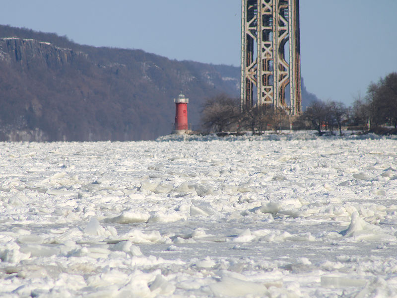
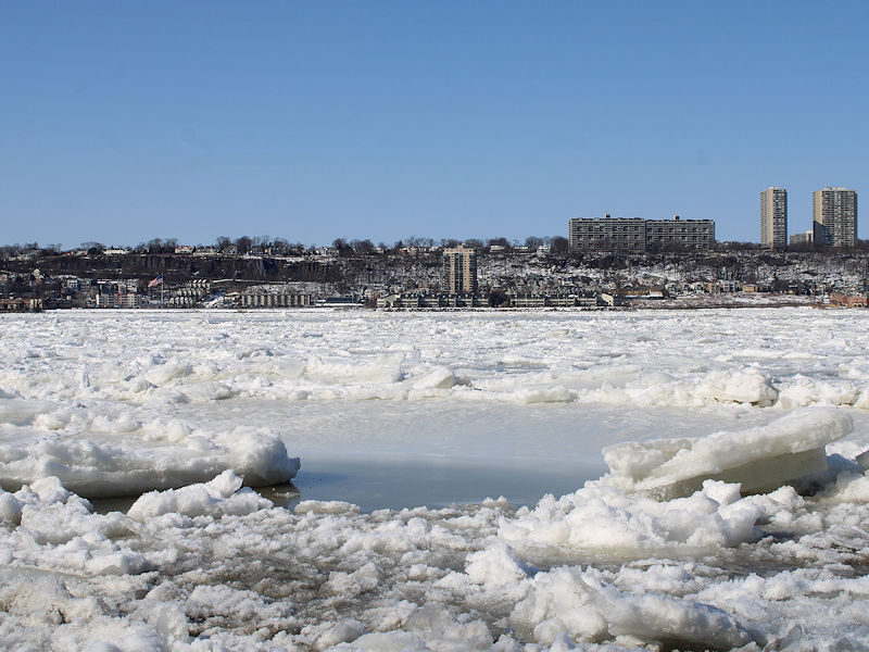
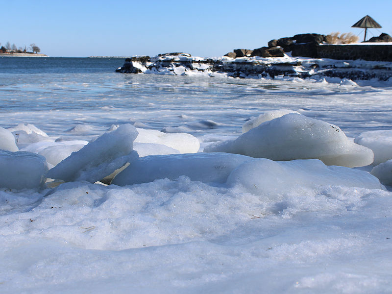
February 2026 OBS & Discussion
donsutherland1 replied to Stormlover74's topic in New York City Metro
The Sound was covered entirely in ice in February 2015. From February 21 viewed from Rye, NY: -
Friday February 6 FROPA / WINDEX small event
donsutherland1 replied to HoarfrostHubb's topic in New England
Essex County has multiple 5" or above snowfall reports. 1 SE Danvers currently leads the way with 6.5" of snow. -
February 2026 OBS & Discussion
donsutherland1 replied to Stormlover74's topic in New York City Metro
Some blowing snow from last night's powder: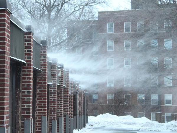
-
February 2026 OBS & Discussion
donsutherland1 replied to Stormlover74's topic in New York City Metro
Light snow is falling in Larchmont. There is a dusting. -
February 2026 OBS & Discussion
donsutherland1 replied to Stormlover74's topic in New York City Metro
I agree. In Central Park, it's a top 5 winter during the 21st century and among the top 25% of winters all-time through February 5th. It has featured a big snowstorm, prolonged cold, prolonged snow cover and several bouts of severe cold. December-January was the coldest since 2010-11. All three winter months will likely finish with below normal temperatures.


