-
Posts
23,786 -
Joined
Content Type
Profiles
Blogs
Forums
American Weather
Media Demo
Store
Gallery
Everything posted by donsutherland1
-
Washington, DC has now picked up 1” or more of rain in two consecutive hours. The last time that occurred was June 25, 2006.
-
Tomorrow will be mainly cloudy and cool. Scattered showers and thundershowers are possible. However, much of the time, there will be no precipitation. In the Southwest, a significant heatwave has now descended on the region. As of 3:35 pm MST, Phoenix had a high temperature of 110°. Phoenix will likely see numerous 110° or above temperatures and several minimum temperatures of 90° or above through the middle of next week. The heat also stretched into the Gulf States and Southeast. Memphis saw a high temperature of 103°, which surpassed the daily record of 101° set in 1969 and tied in 1980. Next week could see a brief surge of heat into the region. Widespread 90s are possible on one or two days. Overall, the month will likely wind up somewhat warmer than normal. During June 16-20, the MJO has been in Phase 1 at an amplitude of 1.500 or above. Of the six cases that saw such an outcome during June 15-25 (1988, 2003, 2010, 2012, 2017 and 2020), four had a warmer than normal July, one was somewhat cooler than normal and one was cooler than normal. The ECMWF seasonal forecast indicates that the summer will be warmer than normal throughout the region and across much of North America. Based on how the pattern has been evolving during the spring transition to summer, it is more likely than not that the warmest anomalies of the summer will likely occur in July and August with June being the coolest of the three months in the Northeast. The latest ECMWF monthly forecast indicates that July will be warmer than June relative to normal and that August will be the warmest summer month relative to normal. In addition, in the 6 past cases when the June AO averaged +0.750 or above (1950-2021), 50% of the following July cases were warmer than normal. 67% of the following August and September cases featured above normal temperatures. The ENSO Region 1+2 anomaly was -1.4°C and the Region 3.4 anomaly was -0.6°C for the week centered around June 29. For the past six weeks, the ENSO Region 1+2 anomaly has averaged -1.28°C and the ENSO Region 3.4 anomaly has averaged -0.73°C. La Niña conditions will likely persist through the summer. The SOI was -3.02. The preliminary Arctic Oscillation (AO) was +0.704 today. On July 6 the MJO was in Phase 4 at an amplitude of 1.431 (RMM). The July 5-adjusted amplitude was 1.593 (RMM). Based on sensitivity analysis applied to the latest guidance, there is an implied 56% probability that New York City will have a warmer than normal July (1991-2020 normal). July will likely finish with a mean temperature near 78.2° (0.7° above normal).
-
Morning thoughts… It will be partly to mostly cloudy and warm. High temperatures will reach the middle and upper 80s in most of the region. Likely high temperatures around the region include: New York City (Central Park): 83° Newark: 89° Philadelphia: 87° Tomorrow will be mainly cloudy and cool. Normals: New York City: 30-Year: 84.8°; 15-Year: 85.5° Newark: 30-Year: 87.0°; 15-Year: 87.8° Philadelphia: 30-Year: 87.9°; 15-Year: 88.7°
-
Unsettled weather could persist through Saturday. Scattered showers and thundershowers will be possible, along with cooler temperatures. However, much of the time, there will be no precipitation. In the Southwest, a significant heatwave is poised to develop. From tomorrow into the middle of next week, Phoenix will likely see numerous 110° or above temperatures and several minimum temperatures of 90° or above. The first 10 days of July could see near normal readings overall in the Northeast. A brief surge of heat could follow afterward. Overall, the month will likely wind up somewhat warmer than normal. The newest EPS weeklies suggest that a sustained period of above normal temperatures could develop after mid-July. During June 16-20, the MJO has been in Phase 1 at an amplitude of 1.500 or above. Of the six cases that saw such an outcome during June 15-25 (1988, 2003, 2010, 2012, 2017 and 2020), four had a warmer than normal July, one was somewhat cooler than normal and one was cooler than normal. The ECMWF seasonal forecast indicates that the summer will be warmer than normal throughout the region and across much of North America. Based on how the pattern has been evolving during the spring transition to summer, it is more likely than not that the warmest anomalies of the summer will likely occur in July and August with June being the coolest of the three months in the Northeast. The latest ECMWF monthly forecast indicates that July will be warmer than June relative to normal and that August will be the warmest summer month relative to normal. In addition, in the 6 past cases when the June AO averaged +0.750 or above (1950-2021), 50% of the following July cases were warmer than normal. 67% of the following August and September cases featured above normal temperatures. The ENSO Region 1+2 anomaly was -1.4°C and the Region 3.4 anomaly was -0.6°C for the week centered around June 29. For the past six weeks, the ENSO Region 1+2 anomaly has averaged -1.28°C and the ENSO Region 3.4 anomaly has averaged -0.73°C. La Niña conditions will likely persist through the summer. The SOI was +4.99. The preliminary Arctic Oscillation (AO) was +1.013 today. On July 5 the MJO was in Phase 4 at an amplitude of 1.589 (RMM). The July 4-adjusted amplitude was 1.647 (RMM). Based on sensitivity analysis applied to the latest guidance, there is an implied 56% probability that New York City will have a warmer than normal July (1991-2020 normal). July will likely finish with a mean temperature near 78.2° (0.7° above normal).
-
Morning thoughts… It will be partly to mostly cloudy and cooler. A few locations could see a shower or thundershower. High temperatures will reach the lower and middle 80s in most of the region. Likely high temperatures around the region include: New York City (Central Park): 82° Newark: 85° Philadelphia: 82° Unsettled weather will continue through Saturday. Normals: New York City: 30-Year: 84.7°; 15-Year: 85.3° Newark: 30-Year: 86.9°; 15-Year: 87.7° Philadelphia: 30-Year: 87.8°; 15-Year: 88.6°
-
Unsettled weather will likely return for tomorrow through Saturday. Showers and thundershowers will be possible, along with cooler temperatures. In the Southwest, a significant heatwave is likely to develop. From Friday into the middle of next week, Phoenix will likely see numerous 110° or above temperatures and several minimum temperatures of 90° or above. The first 10 days of July could see near normal readings overall in the Northeast. A brief surge of heat could follow afterward. Overall, the month will likely wind up somewhat warmer than normal. The newest EPS weeklies suggest that a sustained period of above normal temperatures could develop after mid-July. During June 16-20, the MJO has been in Phase 1 at an amplitude of 1.500 or above. Of the six cases that saw such an outcome during June 15-25 (1988, 2003, 2010, 2012, 2017 and 2020), four had a warmer than normal July, one was somewhat cooler than normal and one was cooler than normal. The ECMWF seasonal forecast indicates that the summer will be warmer than normal throughout the region and across much of North America. Based on how the pattern has been evolving during the spring transition to summer, it is more likely than not that the warmest anomalies of the summer will likely occur in July and August with June being the coolest of the three months in the Northeast. The latest ECMWF monthly forecast indicates that July will be warmer than June relative to normal and that August will be the warmest summer month relative to normal. In addition, in the 6 past cases when the June AO averaged +0.750 or above (1950-2021), 50% of the following July cases were warmer than normal. 67% of the following August and September cases featured above normal temperatures. The ENSO Region 1+2 anomaly was -1.4°C and the Region 3.4 anomaly was -0.6°C for the week centered around June 29. For the past six weeks, the ENSO Region 1+2 anomaly has averaged -1.28°C and the ENSO Region 3.4 anomaly has averaged -0.73°C. La Niña conditions will likely persist through the summer. The SOI was +11.26. The preliminary Arctic Oscillation (AO) was +1.109 today. On July 4 the MJO was in Phase 4 at an amplitude of 1.647 (RMM). The July 3-adjusted amplitude was 1.460 (RMM).
-
Morning thoughts… It will be partly to mostly sunny and very warm.. High temperatures will reach the upper 80s and lower 90s in most of the region. Likely high temperatures around the region include: New York City (Central Park): 87° Newark: 93° Philadelphia: 92° Unsettled weather will develop for tomorrow and Friday. Normals: New York City: 30-Year: 84.5°; 15-Year: 85.1° Newark: 30-Year: 86.8°; 15-Year: 87.5° Philadelphia: 30-Year: 87.7°; 15-Year: 88.4°
-
Tomorrow will be partly to mostly sunny and very warm. However, unsettled weather will likely return for Thursday and Friday. Showers and thundershowers will be likely, along with cooler temperatures. The first 10 days of July could see near normal readings overall in the Northeast. A brief surge of heat could follow afterward. Overall, the month will likely wind up somewhat warmer than normal. The newest EPS weeklies suggest that a sustained period of above normal temperatures could develop after mid-July. During June 16-20, the MJO has been in Phase 1 at an amplitude of 1.500 or above. Of the six cases that saw such an outcome during June 15-25 (1988, 2003, 2010, 2012, 2017 and 2020), four had a warmer than normal July, one was somewhat cooler than normal and one was cooler than normal. The ECMWF seasonal forecast indicates that the summer will be warmer than normal throughout the region and across much of North America. Based on how the pattern has been evolving during the spring transition to summer, it is more likely than not that the warmest anomalies of the summer will likely occur in July and August with June being the coolest of the three months in the Northeast. The latest ECMWF monthly forecast indicates that July will be warmer than June relative to normal and that August will be the warmest summer month relative to normal. In addition, in the 6 past cases when the June AO averaged +0.750 or above (1950-2021), 50% of the following July cases were warmer than normal. 67% of the following August and September cases featured above normal temperatures. The ENSO Region 1+2 anomaly was -1.4°C and the Region 3.4 anomaly was -0.6°C for the week centered around June 29. For the past six weeks, the ENSO Region 1+2 anomaly has averaged -1.28°C and the ENSO Region 3.4 anomaly has averaged -0.73°C. La Niña conditions will likely persist through the summer. The SOI was +8.62. The preliminary Arctic Oscillation (AO) was +0.804 today. On July 3 the MJO was in Phase 4 at an amplitude of 1.460 (RMM). The July 2-adjusted amplitude was 1.195 (RMM).
-
AGW is leading to an increased incidence of marine heatwaves. In the past, the La Niña would have a much larger cooling effect than today. Today, the marine heatwaves offset some of La Niña's cooling influence.
-
Morning thoughts… It will be partly to mostly cloudy and warm. Showers and thundershowers are possible. High temperatures will reach the lower and middle 80s in most of the region. Likely high temperatures around the region include: New York City (Central Park): 83° Newark: 88° Philadelphia: 88° Tomorrow will be fair and very warm, but unsettle3d weather will develop for Thursday and Friday. Normals: New York City: 30-Year: 84.4°; 15-Year: 84.9° Newark: 30-Year: 86.7°; 15-Year: 87.3° Philadelphia: 30-Year: 87.6°; 15-Year: 88.3°
-
Tomorrow will variably cloudy and warm. Showers and thundershowers are possible. The first 10 days of July could see near normal readings overall in the Northeast. A brief surge of heat could follow afterward. Overall, the month will likely wind up somewhat warmer than normal. The newest EPS weeklies suggest that a sustained period of above normal temperatures could develop after mid-July. During June 16-20, the MJO has been in Phase 1 at an amplitude of 1.500 or above. Of the six cases that saw such an outcome during June 15-25 (1988, 2003, 2010, 2012, 2017 and 2020), four had a warmer than normal July, one was somewhat cooler than normal and one was cooler than normal. The ECMWF seasonal forecast indicates that the summer will be warmer than normal throughout the region and across much of North America. Based on how the pattern has been evolving during the spring transition to summer, it is more likely than not that the warmest anomalies of the summer will likely occur in July and August with June being the coolest of the three months in the Northeast. The latest ECMWF monthly forecast indicates that July will be warmer than June relative to normal and that August will be the warmest summer month relative to normal. In addition, in the 6 past cases when the June AO averaged +0.750 or above (1950-2021), 50% of the following July cases were warmer than normal. 67% of the following August and September cases featured above normal temperatures. The ENSO Region 1+2 anomaly was -1.4°C and the Region 3.4 anomaly was -0.6°C for the week centered around June 29. For the past six weeks, the ENSO Region 1+2 anomaly has averaged -1.28°C and the ENSO Region 3.4 anomaly has averaged -0.73°C. La Niña conditions will likely persist through the summer. The SOI was +9.17. The preliminary Arctic Oscillation (AO) was +0.296 today. On July 2 the MJO was in Phase 4 at an amplitude of 1.243 (RMM). The July 1-adjusted amplitude was 1.103 (RMM).
-
Morning thoughts… It will be mostly sunny and warm. High temperatures will reach the middle and upper 80s in most of the region. Likely high temperatures around the region include: New York City (Central Park): 85° Newark: 91° Philadelphia: 88° It will be variably cloudy with some scattered showers and thundershowers tomorrow. Normals: New York City: 30-Year: 84.3°; 15-Year: 84.7° Newark: 30-Year: 86.6°; 15-Year: 87.2° Philadelphia: 30-Year: 87.5°; 15-Year: 88.1°
-
Tomorrow will see spectacular sunshine accompanied by seasonably warm temperatures. The first 10 days of July could see near normal readings overall in the Northeast. A brief surge of heat could follow afterward. Overall, the month will likely wind up somewhat warmer than normal. During June 16-20, the MJO has been in Phase 1 at an amplitude of 1.500 or above. Of the six cases that saw such an outcome during June 15-25 (1988, 2003, 2010, 2012, 2017 and 2020), four had a warmer than normal July, one was somewhat cooler than normal and one was cooler than normal. The ECMWF seasonal forecast indicates that the summer will be warmer than normal throughout the region and across much of North America. Based on how the pattern has been evolving during the spring transition to summer, it is more likely than not that the warmest anomalies of the summer will likely occur in July and August with June being the coolest of the three months in the Northeast. The latest ECMWF monthly forecast indicates that July will be warmer than June relative to normal and that August will be the warmest summer month relative to normal. In addition, in the 6 past cases when the June AO averaged +0.750 or above (1950-2021), 50% of the following July cases were warmer than normal. 67% of the following August and September cases featured above normal temperatures. The ENSO Region 1+2 anomaly was -1.4°C and the Region 3.4 anomaly was -0.6°C for the week centered around June 22. For the past six weeks, the ENSO Region 1+2 anomaly has averaged -1.30°C and the ENSO Region 3.4 anomaly has averaged -0.82°C. La Niña conditions will likely persist through the summer. The SOI was +10.03 The preliminary Arctic Oscillation (AO) was -0.020 today. On July 1 the MJO was in Phase 3 at an amplitude of 1.103 (RMM). The June 30-adjusted amplitude was 1.436 (RMM).
-
The QBO+ is definitely emerging. It will likely be positive or strongly positive during the upcoming winter.
-
Galveston, with a period of record that goes back to May 1874, had its warmest April, May, and June on record.
-
Morning thoughts… Clouds will yield to abundant sunshine. It will be warm. High temperatures will reach the middle and upper 80s in most of the region. Likely high temperatures around the region include: New York City (Central Park): 85° Newark: 91° Philadelphia: 89° Tomorrow will be fair and pleasantly warm. Normals: New York City: 30-Year: 84.1°; 15-Year: 84.5° Newark: 30-Year: 86.4°; 15-Year: 87.0° Philadelphia: 30-Year: 87.4°; 15-Year: 88.0°
-
Some additional scattered showers and thunderstorms are possible as a cold front moves across the region this evening. In the wake of the cold frontal passage, it will be somewhat cooler and less humid for several days. The first 10 days of July could see near normal readings overall in the Northeast. However, the month will likely wind up somewhat warmer than normal. During June 16-20, the MJO has been in Phase 1 at an amplitude of 1.500 or above. Of the six cases that saw such an outcome during June 15-25 (1988, 2003, 2010, 2012, 2017 and 2020), four had a warmer than normal July, one was somewhat cooler than normal and one was cooler than normal. The ECMWF seasonal forecast indicates that the summer will be warmer than normal throughout the region and across much of North America. Based on how the pattern has been evolving during the spring transition to summer, it is more likely than not that the warmest anomalies of the summer will likely occur in July and August with June being the coolest of the three months in the Northeast. The latest ECMWF monthly forecast indicates that July will be warmer than June relative to normal and that August will be the warmest summer month relative to normal. In addition, in the 6 past cases when the June AO averaged +0.750 or above (1950-2021), 50% of the following July cases were warmer than normal. 67% of the following August and September cases featured above normal temperatures. The ENSO Region 1+2 anomaly was -1.4°C and the Region 3.4 anomaly was -0.6°C for the week centered around June 22. For the past six weeks, the ENSO Region 1+2 anomaly has averaged -1.30°C and the ENSO Region 3.4 anomaly has averaged -0.82°C. La Niña conditions will likely persist through the summer. The SOI was +8.37 The preliminary Arctic Oscillation (AO) was -0.329 today. On June 30 the MJO was in Phase 3 at an amplitude of 1.436 (RMM). The June 29-adjusted amplitude was 1.483 (RMM).
-
-
Morning thoughts… Today will variably cloudy and warm. Thunderstorms, some of which could be severe, are likely High temperatures will reach the middle and upper 80s in most of the region. Likely high temperatures around the region include: New York City (Central Park): 86° Newark: 91° Philadelphia: 90° Tomorrow and Independence Day will be fair and pleasantly warm. Normals: New York City: 30-Year: 83.9°; 15-Year: 84.3° Newark: 30-Year: 86.3°; 15-Year: 86.7° Philadelphia: 30-Year: 87.3°; 15-Year: 87.8°
-

Galveston’s Record Warm Late Spring and Early Summer
donsutherland1 replied to donsutherland1's topic in Climate Change
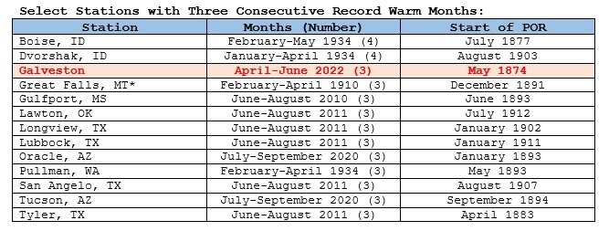
Cases where U.S. stations with long periods of record (POR) hold three consecutive record warm months are uncommon. To compile a list, the following criteria were used: Stations had at least 100 years of monthly data for the reference months (months for which the records were set) All daily data was available in the record warm months or, when missing values were substituted with monthly minimum readings, the record was still intact. It should be noted that stations with shorter period of record have also had three consecutive record warm months. For example, McAllen, TX saw its warmest September, October, and November in 2016, but its period of record begins in June 1941. Anchorage, which experienced its warmest June, July, and August on record in 2019 with a climate record that goes back to November 1953 is another example. Among the cases from stations with long periods of record that saw three consecutive record warm months, 69% have occurred since 2010. Primarily the cases can be found in areas where aridification is underway. The 1930s Dust Bowl era experienced conditions that mimicked the aridification that is underway in the Southwest on account of anthropogenic climate change. A number of stations having shorter periods of record are influenced by warming from marine heatwaves, which have also been increasing in frequency on account of anthropogenic climate change. Through June 2022, a total of 31 stations report three consecutive record warm months, but in the case of Trenton, the minimum temperature data for July 1865 is suspect and numerous dates had missing data. Most of the excluded stations had short periods of record. A few stations had large amounts of missing daily data for the record warm months. Out of the remaining 30 stations, 24 (80%) experienced their three consecutive record warm months during 2010 or later.- 29 replies
-
Under strong sunshine, the mercury soared into the 90s in many parts of the region. High temperatures included: Atlantic City: 91° Baltimore: 96° Boston: 92° Hartford: 94° New York City: 91° Newark: 99° Philadelphia: 94° Washington, DC: 92° Tomorrow will be variably cloudy and warm. A cold front will move across the region bringing thunderstorms. Some of the thunderstorms could grow to severe levels. Afterward, it will be somewhat cooler. The first 10 days of July could see near normal readings overall in the Northeast. However, the month will likely wind up somewhat warmer than normal. During June 16-20, the MJO has been in Phase 1 at an amplitude of 1.500 or above. Of the six cases that saw such an outcome during June 15-25 (1988, 2003, 2010, 2012, 2017 and 2020), four had a warmer than normal July, one was somewhat cooler than normal and one was cooler than normal. The ECMWF seasonal forecast indicates that the summer will be warmer than normal throughout the region and across much of North America. Based on how the pattern has been evolving during the spring transition to summer, it is more likely than not that the warmest anomalies of the summer will likely occur in July and August with June being the coolest of the three months in the Northeast. The latest ECMWF monthly forecast indicates that July will be warmer than June relative to normal and that August will be the warmest summer month relative to normal. In addition, in the 6 past cases when the June AO averaged +0.750 or above (1950-2021), 50% of the following July cases were warmer than normal. 67% of the following August and September cases featured above normal temperatures. The ENSO Region 1+2 anomaly was -1.4°C and the Region 3.4 anomaly was -0.6°C for the week centered around June 22. For the past six weeks, the ENSO Region 1+2 anomaly has averaged -1.30°C and the ENSO Region 3.4 anomaly has averaged -0.82°C. La Niña conditions will likely persist through the summer. The SOI was +19.39 today. The old daily record was +21.58 in 2009) The preliminary Arctic Oscillation (AO) was -0.168 today. On June 29 the MJO was in Phase 3 at an amplitude of 1.483 (RMM). The June 28-adjusted amplitude was 1.555 (RMM).
-
Morning thoughts… Today will partly sunny and hot. High temperatures will reach the lower and middle 90s in most of the region. Coastal areas will be somewhat cooler. Likely high temperatures around the region include: New York City (Central Park): 90° Newark: 96° Philadelphia: 93° Tomorrow will variably cloudy. Thunderstorms are likely. Some could be severe. Normals: New York City: 30-Year: 83.8°; 15-Year: 84.1° Newark: 30-Year: 86.1°; 15-Year: 86.5° Philadelphia: 30-Year: 87.1°; 15-Year: 87.6°
-

Galveston’s Record Warm Late Spring and Early Summer
donsutherland1 replied to donsutherland1's topic in Climate Change
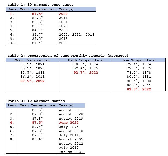
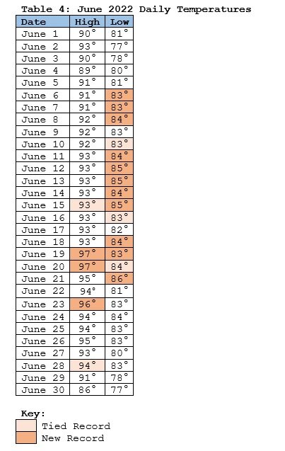
Galveston has seemingly been caught in summer's heat well before the summer even began. April saw Galveston edge past its relatively fresh mark of 75.0° from 2017 with a mean temperature of 75.5°. During May, the fire of summer burned all too hot for the close of spring. In terms of temperatures, the calendar had skipped ahead to June. The May 2022 average temperature of 83.0° demolished the 80.4° record that had been set in 2018. Prior to 2012, no May going back to 1875 had ever seen an average temperature of 80.0°. The unrelenting heat continued through June melting the fairly recent record that displaced the prior longstanding record. June 1881 registered an average temperature of 85.5°. That record stood for 130 years until it was eclipsed with an 86.2° mean temperature in 2011. Eleven years later, that record was erased, as June 2022 logged in with a mean temperature of 87.5°. Never before had Galveston experienced such warmth in July, let alone June. Only three cases in August were hotter. The combination of a warming climate, ongoing drought, persistent heat dome, and exceptionally warm coastal waters produced this outcome. Marine heatwaves have grown 20 times more common on account of anthropogenic climate change. During the month of June, the waters surrounding Galveston Island saw temperatures reaching 90°. Marine heatwaves and/or drought/emergent aridification have been factors in recent years during long periods of exceptional warmth. They have been present in numerous areas when monthly warm temperature records have been set in three consecutive months. Galveston is the most recent such case.- 29 replies
-
- 1
-

-
New York City is concluding a somewhat cooler than normal June, though much of the region saw near or somewhat above normal temperatures. In Central Park, the mean temperature was 71.4°, which was 0.6° below normal. Tomorrow will likely be the hottest day of the week. Many locations will see temperatures top out in the lower and perhaps middle 90s. Parts of the region could even experience a heatwave from tomorrow through Saturday. Afterward, it will be somewhat cooler. The first 10 days of July could see near normal readings overall in the Northeast. However, the month will likely wind up somewhat warmer than normal. Galveston is now wrapping up its third consecutive record warm month. The last time that happened was July-September 2020 in Oracle, AZ and Tucson. Anchorage is also concluding its first June on record where the high temperature reached or exceeded 60° on all 30 days. During June 16-20, the MJO has been in Phase 1 at an amplitude of 1.500 or above. Of the six cases that saw such an outcome during June 15-25 (1988, 2003, 2010, 2012, 2017 and 2020), four had a warmer than normal July, one was somewhat cooler than normal and one was cooler than normal. The ECMWF seasonal forecast indicates that the summer will be warmer than normal throughout the region and across much of North America. Based on how the pattern has been evolving during the spring transition to summer, it is more likely than not that the warmest anomalies of the summer will likely occur in July and August with June being the coolest of the three months in the Northeast. The latest ECMWF monthly forecast indicates that July will be warmer than June relative to normal and that August will be the warmest summer month relative to normal. The ENSO Region 1+2 anomaly was -1.4°C and the Region 3.4 anomaly was -0.6°C for the week centered around June 22. For the past six weeks, the ENSO Region 1+2 anomaly has averaged -1.30°C and the ENSO Region 3.4 anomaly has averaged -0.82°C. La Niña conditions will likely persist through the summer. The SOI was +24.39 today. The old daily record was +21.58 in 2009) The preliminary Arctic Oscillation (AO) was +0.487 today. On June 28 the MJO was in Phase 3 at an amplitude of 1.556 (RMM). The June 27-adjusted amplitude was 1.921 (RMM).


