

donsutherland1
-
Posts
23,980 -
Joined
Content Type
Profiles
Blogs
Forums
American Weather
Media Demo
Store
Gallery
Everything posted by donsutherland1
-
Winter 2022-2023 outlook compiled by The Washington Post. The NOAA, Weather.com, and AccuWeather outlooks are in reasonable agreement, especially with temperatures. WeatherBell is the cold outlier. The article notes of WeatherBell: The winter outlook from WeatherBell Analytics, a weather consulting firm, should put more pep in the step of snow lovers. The firm predicts temperatures that are normal to slightly below normal for nearly all of the country from November 2022 to March 2023. https://www.washingtonpost.com/climate-environment/2022/10/13/winter-outlooks-united-states-snow/
-
Morning thoughts… Today will be mostly cloudy and mild. There will be some periods of rain and perhaps a thunderstorm. High temperatures will reach the upper 60s and lower 70s in most of the region. Likely high temperatures around the region include: New York City (Central Park): 67° Newark: 69° Philadelphia: 70° Much cooler air will move into the region early next week. Normals: New York City: 30-Year: 65.5°; 15-Year: 66.5° Newark: 30-Year: 67.0°; 15-Year: 68.3° Philadelphia: 30-Year: 68.3°; 15-Year: 69.2°
-
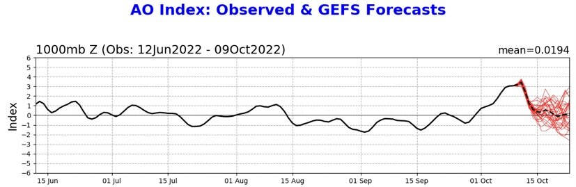
Tomorrow will be mostly cloudy with periods of rain. Some locations could experience a thunderstorm. It will be mild with temperatures rising into the middle and upper 60s. The mild weather will continue into the weekend. However, more cold air could begin to arrive late in the weekend. Early next week could turn much cooler. Out West, Portland reached 80° for the 8th time this month. The previous October record was 6 days. That record was set in 1952 and tied in 1980 and 1991. Since 1950, 15/21 (71%) of cases with an ENSO Region 1+2 anomaly of -0.75°C or below were warmer than normal in the Middle Atlantic region, including Philadelphia and New York City. 48% were 1° or more above average in New York City and 62% were 1° or more above average in Philadelphia. Just 14% were 1° or more below normal in New York City while 24% were 1° or more below normal in Philadelphia. One-third of cases in both cities saw a monthly mean temperature of 60° or above. Overall, such ENSO conditions also favored warmth in the Central and Northern Plains, along with dry conditions in the Plains States. October 1988 was the coldest exception. The closing week of September saw the coldest Region 1+2 anomaly since September 1988. That development has increased the probability of a cooler outcome this month. A cooler than normal October is the base case. October 2022 is well on track for a colder than normal outcome. For example, 26/29 (89.7%) cases that saw October 1-10 wind up with a mean temperature of 56.5° or below in New York City, had a monthly mean temperature below the current normal average of 57.9°. The ENSO Region 1+2 anomaly was -1.6°C and the Region 3.4 anomaly was -0.8°C for the week centered around October 5. For the past six weeks, the ENSO Region 1+2 anomaly has averaged -1.07°C and the ENSO Region 3.4 anomaly has averaged -0.87°C. La Niña conditions will likely persist through the fall. The SOI was +21.53 today. The preliminary Arctic Oscillation (AO) was +2.318 today. On October 10 the MJO was in Phase 6 at an amplitude of 1.330 (RMM). The October 9-adjusted amplitude was 1.143 (RMM). Based on sensitivity analysis applied to the latest guidance, there is an implied 74% probability that New York City will have a cooler than normal October (1991-2020 normal). October will likely finish with a mean temperature near 55.9° (2.0° below normal).
-
Morning thoughts… Today will be partly sunny and warm. High temperatures will reach the upper 60s and lower 70s in most of the region. Likely high temperatures around the region include: New York City (Central Park): 69° Newark: 71° Philadelphia: 72° Slightly cooler air will arrive to end the week. Normals: New York City: 30-Year: 65.8°; 15-Year: 66.9° Newark: 30-Year: 67.4°; 15-Year: 68.7° Philadelphia: 30-Year: 68.7°; 15-Year: 69.6°
-
Temperatures reached 70° or above in many parts of the region this afternoon. Tomorrow will be another warm day. The remainder of the week will see milder temperatures. Highs will mainly reach the middle and upper 60s. The temperature could reach or exceed 70° during the peak of the warmth. However, more cold air could arrive during the weekend with the cool weather continuing into next week. Since 1950, 15/21 (71%) of cases with an ENSO Region 1+2 anomaly of -0.75°C or below were warmer than normal in the Middle Atlantic region, including Philadelphia and New York City. 48% were 1° or more above average in New York City and 62% were 1° or more above average in Philadelphia. Just 14% were 1° or more below normal in New York City while 24% were 1° or more below normal in Philadelphia. One-third of cases in both cities saw a monthly mean temperature of 60° or above. Overall, such ENSO conditions also favored warmth in the Central and Northern Plains, along with dry conditions in the Plains States. October 1988 was the coldest exception. The closing week of September saw the coldest Region 1+2 anomaly since September 1988. That development has increased the probability of a cooler outcome this month. A cooler than normal October is the base case. October 2022 is well on track for a colder than normal outcome. For example, 26/29 (89.7%) cases that saw October 1-10 wind up with a mean temperature of 56.5° or below in New York City, had a monthly mean temperature below the current normal average of 57.9°. The ENSO Region 1+2 anomaly was -1.6°C and the Region 3.4 anomaly was -0.8°C for the week centered around October 5. For the past six weeks, the ENSO Region 1+2 anomaly has averaged -1.07°C and the ENSO Region 3.4 anomaly has averaged -0.87°C. La Niña conditions will likely persist through the fall. The SOI was +13.02 today. The preliminary Arctic Oscillation (AO) was +3.395 today. That broke the daily record high of +2.508, which was set in 2008. On October 8 the MJO was in Phase 5 at an amplitude of 1.141 (RMM). The October 7-adjusted amplitude was 0.944 (RMM). Based on sensitivity analysis applied to the latest guidance, there is an implied 72% probability that New York City will have a cooler than normal October (1991-2020 normal). October will likely finish with a mean temperature near 55.9° (2.0° below normal).
-
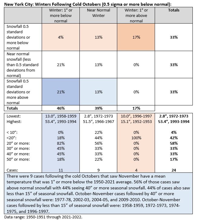
Just as with the cold November cases, there was a split between the outcomes: 44% above normal snowfall; 56% below normal snowfall. 38% of cases saw 30" or more snow (all of them had 40" or more). 19% of cases had 50" or more snowfall. 44% of cases also saw less than 20" of snowfall. Mean: 28.8"; Median: 24.5". This was from the same 1950-51 through 2021-22 dataset.
-
There is a greater tendency for cold Octobers to be followed by near normal or colder than normal winters than for cold Octobers to be followed by snowy winters. Below is a summary from 1950-51 through 2021-2022 for New York City's Central Park. October 2022 appears likely to meet the threshold (56.5° or below mean temperature) for a cold October during the period covered. Numerous earlier Octobers were colder and that would skew the numbers given the warming that has occurred. Probabilities of snowier outcomes may also be modestly higher than shown, as winters have become snowier, in general (1991-2020 period) than during the early part of the covered period (1951-80). For the cold October and November cases, the four winters with 40" or more snowfall had a December mean temperature below 38.5°. Three of the four cases with 15" or less snowfall had December mean temperatures at or above 38.5°. December 1958 was the single exception with a mean temperature of 29.3°.
-
Morning thoughts… Today will be mostly sunny and warm. High temperatures will reach the upper 60s and lower 70s in most of the region. Likely high temperatures around the region include: New York City (Central Park): 69° Newark: 71° Philadelphia: 74° Slightly cooler air will arrive to end the week. Normals: New York City: 30-Year: 66.2°; 15-Year: 67.3° Newark: 30-Year: 67.8°; 15-Year: 69.2° Philadelphia: 30-Year: 69.0°; 15-Year: 70.0°
-
At New York City, the first 10 days of October had a mean temperature of 56.3°. That was 5.6° below normal. Mean temperatures for select cities were: Boston: 57.2°/0.9° below normal (coolest since 2016) Bridgeport: 55.6°/4.5° below normal (coolest since 2003) Islip: 56.7°/3.0° below normal (coolest since 2003) New York City: 56.3°/5.6° below normal (coolest since 2003) Newark: 53.9°/8.2° below normal (coolest since 1965) ***tied as the 3rd coolest first 10 days of October*** Philadelphia: 57.3°/5.7° below normal (coolest since 2003) The remainder of the week will see milder temperatures. Highs will mainly reach the middle and upper 60s. The temperature could reach or exceed 70° during the peak of the warmth. However, more cold air could arrive late in the week sending readings below normal for another weekend into early next week. Since 1950, 15/21 (71%) of cases with an ENSO Region 1+2 anomaly of -0.75°C or below were warmer than normal in the Middle Atlantic region, including Philadelphia and New York City. 48% were 1° or more above average in New York City and 62% were 1° or more above average in Philadelphia. Just 14% were 1° or more below normal in New York City while 24% were 1° or more below normal in Philadelphia. One-third of cases in both cities saw a monthly mean temperature of 60° or above. Overall, such ENSO conditions also favored warmth in the Central and Northern Plains, along with dry conditions in the Plains States. October 1988 was the coldest exception. The closing week of September saw the coldest Region 1+2 anomaly since September 1988. That development has increased the probability of a cooler outcome this month. A cooler than normal October is the base case. October 2022 is well on track for a colder than normal outcome. For example, 26/29 (89.7%) cases that saw October 1-10 wind up with a mean temperature of 56.5° or below in New York City, had a monthly mean temperature below the current normal average of 57.9°. The ENSO Region 1+2 anomaly was -1.6°C and the Region 3.4 anomaly was -0.8°C for the week centered around October 5. For the past six weeks, the ENSO Region 1+2 anomaly has averaged -1.07°C and the ENSO Region 3.4 anomaly has averaged -0.87°C. La Niña conditions will likely persist through the fall. The SOI was +17.53 today. The preliminary Arctic Oscillation (AO) was +3.117 today. That broke the previous daily record high of +3.037 from 2001. On October 7 the MJO was in Phase 5 at an amplitude of 0.936 (RMM). The October 6-adjusted amplitude was 0.817 (RMM). Based on sensitivity analysis applied to the latest guidance, there is an implied 72% probability that New York City will have a cooler than normal October (1991-2020 normal). October will likely finish with a mean temperature near 55.9° (2.0° below normal).
-
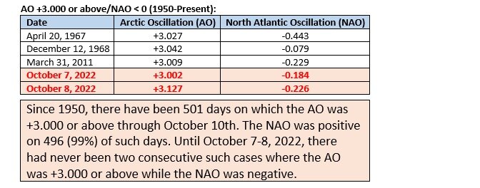
That probably played a role. Greenland’s record September warmth likely also set the stage.
-
It was historic. Recently, the AO was +3.000 or above while the NAO was negative on two consecutive days for the first time on record.
-
The AO and NAO are different indices. There can be cases where they are in different states. Wave lengths are still relatively short, so the influence of the AO+ has been offset.
-
Morning thoughts… Today will turn partly sunny and milder. High temperatures will reach the middle and upper 60s in most of the region. Likely high temperatures around the region include: New York City (Central Park): 67° Newark: 68° Philadelphia: 69° Tomorrow will turn milder. Normals: New York City: 30-Year: 66.6°; 15-Year: 67.7° Newark: 30-Year: 68.2°; 15-Year: 69.6° Philadelphia: 30-Year: 69.4°; 15-Year: 70.5°
-
New York City-JFK: 45 New York City-LGA: 46 New York City-NYC: 44 Newark: 37 Many 30s outside the City.
-
After a very cool start that saw the mercury approach record lows in a few locations, the temperature rose into the upper 50s and lower 60s across much of the region. Through 5 pm, highs included: New York City: 61°; Newark: 61°; and, Philadelphia: 65°. Nevertheless, the first 10 days of October remain on track to be much cooler than normal. The temperature will likely average 5°-6° below normal during the October 1-10 period, even with the return of milder air starting tomorrow. However, more cold air could arrive late next week sending readings below normal for another weekend. Out West, Portland saw the temperature reach 80° by 2 pm PDT. That was the 7th 80° high temperature this month. The old October record was 6 days, which was set in 1952 and tied in 1980 and 1991. Since 1950, 15/21 (71%) of cases with an ENSO Region 1+2 anomaly of -0.75°C or below were warmer than normal in the Middle Atlantic region, including Philadelphia and New York City. 48% were 1° or more above average in New York City and 62% were 1° or more above average in Philadelphia. Just 14% were 1° or more below normal in New York City while 24% were 1° or more below normal in Philadelphia. One-third of cases in both cities saw a monthly mean temperature of 60° or above. Overall, such ENSO conditions also favored warmth in the Central and Northern Plains, along with dry conditions in the Plains States. October 1988 was the coldest exception. The closing week of September saw the coldest Region 1+2 anomaly since September 1988. That development has increased the probability of a cooler outcome this month. A cooler than normal October is the base case. The ENSO Region 1+2 anomaly was -1.7°C and the Region 3.4 anomaly was -0.8°C for the week centered around September 28. For the past six weeks, the ENSO Region 1+2 anomaly has averaged -0.88°C and the ENSO Region 3.4 anomaly has averaged -0.88°C. La Niña conditions will likely persist through the fall. The SOI was +24.11 today. The preliminary Arctic Oscillation (AO) was +2.905 today. The previous record high was +2.709, which was set in 1990. On October 6 the MJO was in Phase 5 at an amplitude of 0.813 (RMM). The October 5-adjusted amplitude was 0.717 (RMM). Based on sensitivity analysis applied to the latest guidance, there is an implied 71% probability that New York City will have a cooler than normal October (1991-2020 normal). October will likely finish with a mean temperature near 55.9° (2.0° below normal).
-
After the coolest morning so far this season, temperatures rebounded into the lower 60s on a sun-filled October day.


-
Bridgeport: September 21, 1956 Islip: September 10, 1975 New Haven: September 17, 1950 New York City-JFK: October 4, 1996 New York City-LGA: October 1, 1947 New York City-NYC: September 30, 1912 Newark: September 21, 1956 White Plains: September 20, 1979, 1993, and 2004
-
Morning thoughts… Today will be partly sunny and unseasonably cool. High temperatures will reach the upper 50s and lower 60s in most of the region. Likely high temperatures around the region include: New York City (Central Park): 60° Newark: 62° Philadelphia: 63° Tomorrow will turn milder. Normals: New York City: 30-Year: 67.0°; 15-Year: 68.1° Newark: 30-Year: 68.6°; 15-Year: 70.0° Philadelphia: 30-Year: 68.6°; 15-Year: 70.9°
-
Despite abundant sunshine, the temperature peaked at 58° at New York City and Newark. The thermometer topped out at 62° in Philadelphia. Parts of the region have concluded their coolest first week of October in at least 6 years. October 1-7 mean temperatures included: Allentown: 54.6° (coolest since 2011) Atlantic City: 58.5° (coolest since 2011) Boston: 58.2° (coolest since 2016) Bridgeport: 56.9° (coolest since 2008) Islip: 58.5° (coolest since 2015) New York City-JFK: 57.3° (coolest since 2003) New York City-LGA: 58.8° (coolest since 2015) New York City-NYC: 56.9° (coolest since 2008) Newark: 55.0° (coolest since 2003) Philadelphia: 58.1° (coolest since 2011) Providence: 57.5° (coolest since 2015) Scranton: 54.6° (coolest since 2011) White Plains: 53.3° (coolest since 2003) Both New York City and Philadelphia had a lower mean temperature than Boston. Since 1874, there were only 6 such prior cases: 1920, 1939, 1963, 1977, 1987, and 2011. In 1987, Portland and Seattle had their previous warmest first week on record in October. Those records were surpassed this year. Portland saw the temperature soar to 87° today. That smashed the daily record of 82° from 1971. It is also the latest 87° temperature on record. All said, the first 10 days of October remain on track to be much cooler than normal. The temperature will likely average 4°-6° below normal during the October 1-10 period. Afterward, the pattern evolution will depend on the state of blocking and the influence of the cool ENSO Region 1+2 region. Since 1950, 15/21 (71%) of cases with an ENSO Region 1+2 anomaly of -0.75°C or below were warmer than normal in the Middle Atlantic region, including Philadelphia and New York City. 48% were 1° or more above average in New York City and 62% were 1° or more above average in Philadelphia. Just 14% were 1° or more below normal in New York City while 24% were 1° or more below normal in Philadelphia. One-third of cases in both cities saw a monthly mean temperature of 60° or above. Overall, such ENSO conditions also favored warmth in the Central and Northern Plains, along with dry conditions in the Plains States. October 1988 was the coldest exception. The closing week of September saw the coldest Region 1+2 anomaly since September 1988. That development has increased the probability of a cooler outcome this month. A cooler than normal October is the base case. The ENSO Region 1+2 anomaly was -1.7°C and the Region 3.4 anomaly was -0.8°C for the week centered around September 28. For the past six weeks, the ENSO Region 1+2 anomaly has averaged -0.88°C and the ENSO Region 3.4 anomaly has averaged -0.88°C. La Niña conditions will likely persist through the fall. The SOI was +18.05 today. The preliminary Arctic Oscillation (AO) was +3.132 today. That broke the daily record high figure of +2.602 from 1988. On October 5 the MJO was in Phase 4 at an amplitude of 0.716 (RMM). The October 4-adjusted amplitude was 0.685 (RMM). Based on sensitivity analysis applied to the latest guidance, there is an implied 71% probability that New York City will have a cooler than normal October (1991-2020 normal). October will likely finish with a mean temperature near 55.9° (2.0° below normal).
-
Despite bright sunshine, the temperature only reached 58 degrees in New York City. Some scenes from the New York Botanical Garden:


-
Morning thoughts… Today will be partly sunny and unseasonably cool. High temperatures will reach the upper 50s and lower 60s in most of the region. Likely high temperatures around the region include: New York City (Central Park): 59° Newark: 61° Philadelphia: 62° The cool weather will continue through Monday. Normals: New York City: 30-Year: 67.4°; 15-Year: 68.6° Newark: 30-Year: 69.0°; 15-Year: 70.4° Philadelphia: 30-Year: 61.3°; 15-Year: 71.3°
-
A cold front is now crossing the region. As a result, another cool weekend lies ahead. All said, the first 10 days of October remain on track to be much cooler than normal. The temperature will likely average 4°-6° below normal during the October 1-10 period. Afterward, the pattern evolution will depend on the state of blocking and the influence of the cool ENSO Region 1+2 region. Since 1950, 15/21 (71%) of cases with an ENSO Region 1+2 anomaly of -0.75°C or below were warmer than normal in the Middle Atlantic region, including Philadelphia and New York City. 48% were 1° or more above average in New York City and 62% were 1° or more above average in Philadelphia. Just 14% were 1° or more below normal in New York City while 24% were 1° or more below normal in Philadelphia. One-third of cases in both cities saw a monthly mean temperature of 60° or above. Overall, such ENSO conditions also favored warmth in the Central and Northern Plains, along with dry conditions in the Plains States. October 1988 was the coldest exception. The closing week of September saw the coldest Region 1+2 anomaly since September 1988. That development has increased the probability of a cooler outcome this month. The ENSO Region 1+2 anomaly was -1.7°C and the Region 3.4 anomaly was -0.8°C for the week centered around September 28. For the past six weeks, the ENSO Region 1+2 anomaly has averaged -0.88°C and the ENSO Region 3.4 anomaly has averaged -0.88°C. La Niña conditions will likely persist through the fall. The SOI was +20.69 today. The preliminary Arctic Oscillation (AO) was +2.948 today. On October 4 the MJO was in Phase 4 at an amplitude of 0.685 (RMM). The October 3-adjusted amplitude was 0.683 (RMM). Based on sensitivity analysis applied to the latest guidance, there is an implied 67% probability that New York City will have a cooler than normal October (1991-2020 normal). October will likely finish with a mean temperature near 56.1° (1.8° below normal).
-
Under mainly sunny skies, the temperature rebounded into the lower and middle 70s across the region. Tomorrow will be another warm day. However, the warmth will be short-lived. A cold front will cross the region, ushering in another cool weekend. All said, the first 10 days of October remain on track to be much cooler than normal. The temperature will likely average 4°-6° below normal during the October 1-10 period. Afterward, the pattern evolution will depend on the state of blocking and the influence of the cool ENSO Region 1+2 region. Since 1950, 15/21 (71%) of cases with an ENSO Region 1+2 anomaly of -0.75°C or below were warmer than normal in the Middle Atlantic region, including Philadelphia and New York City. 48% were 1° or more above average in New York City and 62% were 1° or more above average in Philadelphia. Just 14% were 1° or more below normal in New York City while 24% were 1° or more below normal in Philadelphia. One-third of cases in both cities saw a monthly mean temperature of 60° or above. Overall, such ENSO conditions also favored warmth in the Central and Northern Plains, along with dry conditions in the Plains States. October 1988 was the coldest exception. The closing week of September saw the coldest Region 1+2 anomaly since September 1988. That development increases the probability of a cooler outcome this month. The ENSO Region 1+2 anomaly was -1.7°C and the Region 3.4 anomaly was -0.8°C for the week centered around September 28. For the past six weeks, the ENSO Region 1+2 anomaly has averaged -0.88°C and the ENSO Region 3.4 anomaly has averaged -0.88°C. La Niña conditions will likely persist through the fall. The SOI was +25.46 today. The old daily record was +19.72, which was set in 2017. The preliminary Arctic Oscillation (AO) was +2.464 today. On October 3 the MJO was in Phase 4 at an amplitude of 0.685 (RMM). The October 2-adjusted amplitude was 0.855 (RMM).
-
Morning thoughts… Today will be partly sunny and warmer. High temperatures will reach the lower and perhaps middle 70s in most of the region. Likely high temperatures around the region include: New York City (Central Park): 72° Newark: 74° Philadelphia: 75° Tomorrow will turn warmer. Normals: New York City: 30-Year: 68.2°; 15-Year: 69.4° Newark: 30-Year: 69.8°; 15-Year: 71.3° Philadelphia: 30-Year: 71.0°; 15-Year: 72.2°
-
A brief period of warmer readings will develop tomorrow and continue through Friday before another strong cold front crosses the region on Friday. All said, the first 10 days of October are on track to be much cooler than normal. The temperature will likely average 4°-6° below normal during the October 1-10 period. Afterward, the pattern evolution will depend on the state of blocking and the influence of the cool ENSO Region 1+2 region. Since 1950, 15/21 (71%) of cases with an ENSO Region 1+2 anomaly of -0.75°C or below were warmer than normal in the Middle Atlantic region, including Philadelphia and New York City. 48% were 1° or more above average in New York City and 62% were 1° or more above average in Philadelphia. Just 14% were 1° or more below normal in New York City while 24% were 1° or more below normal in Philadelphia. One-third of cases in both cities saw a monthly mean temperature of 60° or above. Overall, such ENSO conditions also favored warmth in the Central and Northern Plains, along with dry conditions in the Plains States. October 1988 was the coldest exception. The closing week of September saw the coldest Region 1+2 anomaly since September 1988. That development raises the probability of a cooler exception this month. The ENSO Region 1+2 anomaly was -1.7°C and the Region 3.4 anomaly was -0.8°C for the week centered around September 28. For the past six weeks, the ENSO Region 1+2 anomaly has averaged -0.88°C and the ENSO Region 3.4 anomaly has averaged -0.88°C. La Niña conditions will likely persist through the fall. The SOI was +37.19 today. The old daily record was +27.39, which was set in 1999. The preliminary Arctic Oscillation (AO) was +1.570 today. On October 3 the MJO was in Phase 4 at an amplitude of 0.852 (RMM). The October 2-adjusted amplitude was 0.932 (RMM).


