donsutherland1
-
Posts
23,765 -
Joined
Content Type
Profiles
Blogs
Forums
American Weather
Media Demo
Store
Gallery
Everything posted by donsutherland1
-
E PA/NJ/DE Winter 2023-2024 OBS/Discussion
donsutherland1 replied to The Iceman's topic in Philadelphia Region
No record streak there. -
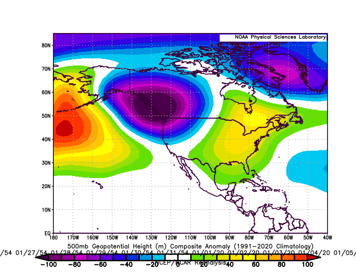
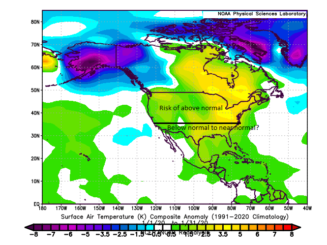
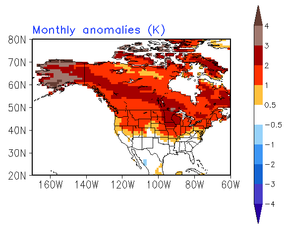
December is concluding in mild fashion. Locations including International Falls, Milwaukee, and Minneapolis will see their warmest December on record. New York City will finish its second warmest December on record. Strong El Niño events like the ongoing event typically see most of their snowfall after the first half of January (approximately 75% of their seasonal snowfall). The historic snow drought that grips Baltimore, New York City, and Philadelphia makes the wait almost unbearable. Patience will continue to be required. Looking ahead to January, the picture is complex. The strong El Niño event is likely to see a continuation of the negative Pacific Decadal Oscillation (possibly -1.000 standard deviations or more relative to normal). That combination would be almost unprecedented. Since 1950, there are two cases where the ENSO Region 3.4 anomaly was +0.50°C or above and the PDO was -0.95 sigma or below (1954: El Niño winter and 2020 (neutral winter that fell just short of El Niño status). Composite 500 mb Anomalies: 1954 was characterized by expansive and deep cold across Canada. That is not the case this year. Moreover, the climate has warmed substantially since 1954. That likely rules out its temperature anomalies. 2020 had a somewhat similar trough-ridge pattern with much more expansive warmth. However, the current winter has a much more active subtropical jet. Hence cooler anomalies than January 2020 (due, in part, to more frequent precipitation) are likely across the southern tier of the CONUS. January 2020 can serve as a reference for a reasonable "worst case" scenario. The January 2020 map is below: The latest CFSv2 monthly forecast provides an illustration of the risks: January 2020 featured below average snowfall across the New York City and Philadelphia areas. Monthly snowfall amounts included: Bridgeport: 4.6"; Islip: 2.5"; New York City: 2.3"; Newark: 2.7"; and, Philadelphia: 0.2" What could go right? 1. The PDO- could erode substantially introducing a 1965-1966-style breakdown of the generally warm pattern (albeit with less Arctic air than was available then) 2. Atlantic blocking could predominate given some storm track opportunities for snowfall 3. The sudden stratospheric warming event could ultimately lead to colder air coming into eastern North America toward the end of the month, even if it initially flows into the West What could go wrong? 1. The PDO- remains strong (-1.000 or below) 2. Most of the impact of the sudden stratospheric warming event winds up in Eurasia 3. Atlantic blocking breaks down 4. The subtropical jet weakens At present, it still appears that the first 1-2 weeks of January could wind up closer to normal than has been the case for December. Such temperatures would mark a dramatic departure from the "torch" that defined the closing week of December (widespread anomalies of 8° or more above normal in the Northeast). Initially, the first week of January could start dry, but a wetter pattern could emerge afterward. The key question concerns whether there will be sufficient cold still available. Afterward, there has been persistent guidance suggesting that the trough could shift out West with possible ridging developing in the East (2020 lite?). The EPS ensembles have been showing the development of a PNA- during the second week of the month, which would support conditions conducive to the trough's shifting to the West. Severe cold appears unlikely in the Northeast through at least the first half of January. Big snowstorms (6" or greater) for Washington to New York City also appear unlikely through the first half of January (ensemble guidance + strong El Niño climatology). None of this means that winter has been canceled. It suggests that the best wintry conditions are not likely during the first half of January.
-
E PA/NJ/DE Winter 2023-2024 OBS/Discussion
donsutherland1 replied to The Iceman's topic in Philadelphia Region
Baltimore’s record is now 701 days. Washington, DC does not have a record streak. -
Some of the cherry blossoms have come into bloom in Central Park, too.
-
E PA/NJ/DE Winter 2023-2024 OBS/Discussion
donsutherland1 replied to The Iceman's topic in Philadelphia Region
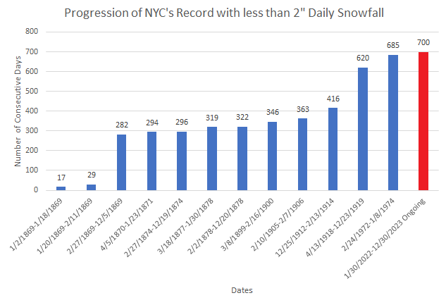
NYC is in a similar predicament. 685 days and counting (old record: 383 days). -
Today will be New York City's 700th consecutive day on which it has received less than 2" of daily snowfall.
-
E PA/NJ/DE Winter 2023-2024 OBS/Discussion
donsutherland1 replied to The Iceman's topic in Philadelphia Region
Today will mark Philadelphia's 700th consecutive day on which it has received less than 1" of daily snowfall.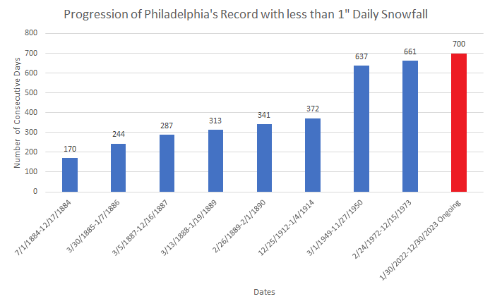
-
That now happens about once every four years. The most recent occurrence prior to this year was 2020. Columbia, SC will have more such days for the first time since 1984 and only 6th time overall.
-
Baltimore saw its record stretch without daily snowfall of 1" or more reach 700 days today. Philadelphia will reach 700 days tomorrow. The unseasonably mild weather will likely continue through the remainder of December, but readings will be somewhat cooler than they were today. The first week of January will likely feature somewhat below normal temperatures. However, severe cold appears unlikely. Initially, the arrival of a colder regime could coincide with a drier one, so snowfall prospects will remain limited. The second week of January could offer better opportunities for snowfall, as the retreat of cold air could occur while the pattern becomes wetter. There remains some uncertainty concerning the magnitude and duration of the colder period that could develop. At this time, it appears more likely than not that it will be seasonably cold or somewhat colder than normal with a duration of 1-2 weeks. The ENSO Region 1+2 anomaly was +1.6°C and the Region 3.4 anomaly was +2.0°C for the week centered around December 20. For the past six weeks, the ENSO Region 1+2 anomaly has averaged +1.75°C and the ENSO Region 3.4 anomaly has averaged +1.98°C. A basinwide El Niño event is ongoing. El Niño conditions may strengthen somewhat further this month. The SOI was +1.09 today. The preliminary Arctic Oscillation (AO) was -0.852 today. Strong blocking in the final week of November, as occurred this year, has often been followed by frequent blocking in December and January. Atlantic blocking is continuing to redevelop. On December 27 the MJO was in Phase 1 at an amplitude of 2.028 (RMM). The December 26-adjusted amplitude was 1.837 (RMM). Based on sensitivity analysis applied to the latest guidance, there is an implied near 100% probability that New York City will have a warmer than normal December (1991-2020 normal). December will likely finish with a mean temperature near 44.5° (5.4° above normal). That would make December 2023 the 2nd warmest December on record. With 2023 virtually certain to be among the 10 warmest Decembers on record, 60% of New York City's 10 warmest Decembers have occurred since 2000, including 40% since 2010, and all have occurred since 1980. Records go back to 1869.
-
New York City's second warmest December on record is concluding. Blossoms can be found in parts of the New York Botanical Garden.


-
After days of overcast skies, bouts of fog, rain, mist, and drizzle, the sun finally returned today.


-
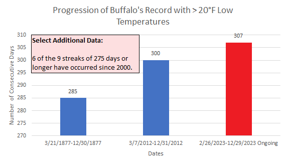
In addition to ongoing record streaks without 1" or 2" daily snowfall in New York City, today will be Buffalo's record 307th consecutive day on which the temperature has not fallen into the teens. The latest first occurrence of temperatures in the teens was January 3, 2022. That mark could be beaten this winter.
-
Yes. It's one variable. It can be important, but other variables can more than offset it.
-
The MJO's current passage through Phase 1 during which the preliminary amplitude has reached as high as 2.028, is the strongest on record for Phase 1 for the last 10 days of December. Daily MJO data recordkeeping began in 1974.
-
With no snowfall in the forecast, today will become Baltimore's 700th consecutive day during which the City has not seen at least 1" of daily snowfall.

-
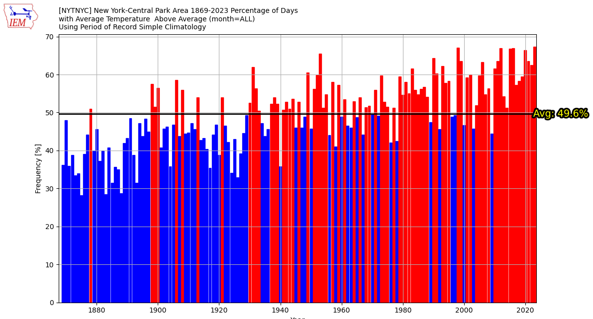
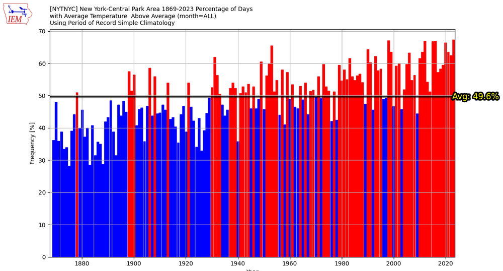
% of Below and Above Normal Days in New York City. The last year with a majority of below normal days was 2009 when 56% of days were cooler than normal.
-
That was likely it. It was a large lake.
-
I saw a caldera from an ancient explosion while out there, but don't recall the name of it. We even experienced a strong aftershock while there. I had spent time seeing a number of the Hindu temples (many in ruins) and a Buddhist temple.
-
I was there. It's a fabulous place.
-
1987-88 was a second year El Niño that peaked late summer/early fall and then collapsed late winter/early spring. The following winter featured a strong La Niña event.
-
In the wake of the region's most recent rainfall, Allentown, Bridgeport, Manchester, NH and New Haven have now seen their wettest December on record. New York City's seasonal precipitation has climbed to 59.19", which ranks as the 11th highest figure on record. Temperatures rose into the 50s across much of the region. Islip saw the temperature hit 56°, which tied the daily record set in 1971, and tied in 2008 and 2018. Tomorrow will be another very mild day. Additional showers are possible, even as some sunshine is also likely. The unseasonably mild weather will likely continue through the remainder of December, but readings will be somewhat cooler than tomorrow's highs. Somewhat colder air should begin moving into the region to close December. The first week of January will likely feature somewhat below normal temperatures. However, severe cold appears unlikely. Initially, the arrival of a colder regime could coincide with a drier one, so snowfall prospects will remain limited. The second week of January could offer better opportunities for snowfall, as the retreat of cold air could occur while the pattern becomes wetter. There remains some uncertainty concerning the magnitude and duration of the colder period that could develop. At this time, it appears more likely than not that it will be seasonably cold or somewhat colder than normal with a duration of 1-2 weeks. The ENSO Region 1+2 anomaly was +1.6°C and the Region 3.4 anomaly was +2.0°C for the week centered around December 20. For the past six weeks, the ENSO Region 1+2 anomaly has averaged +1.75°C and the ENSO Region 3.4 anomaly has averaged +1.98°C. A basinwide El Niño event is ongoing. El Niño conditions may strengthen somewhat further this month. The SOI was -3.79 today. The preliminary Arctic Oscillation (AO) was -0.741 today. Strong blocking in the final week of November, as occurred this year, has often been followed by frequent blocking in December and January. Atlantic blocking is continuing to redevelop. On December 26 the MJO was in Phase 1 at an amplitude of 1.837 (RMM). The December 25-adjusted amplitude was 1.774 (RMM). Based on sensitivity analysis applied to the latest guidance, there is an implied near 100% probability that New York City will have a warmer than normal December (1991-2020 normal). December will likely finish with a mean temperature near 44.4° (5.3° above normal). That would make December 2023 the 2nd warmest December on record. With 2023 virtually certain to be among the 10 warmest Decembers on record, 60% of New York City's 10 warmest Decembers have occurred since 2000, including 40% since 2010, and all have occurred since 1980. Records go back to 1869.
-
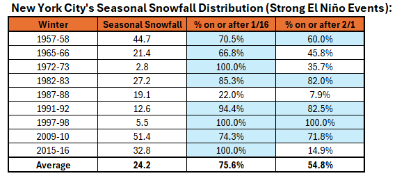
NYC snowfall statistics for strong El Niño winters. Slow starts to the snow season are generally the rule. Around three-fourths of seasonal snowfall in such winters occurs after January 15th.
-
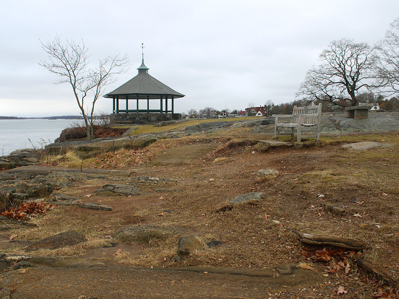
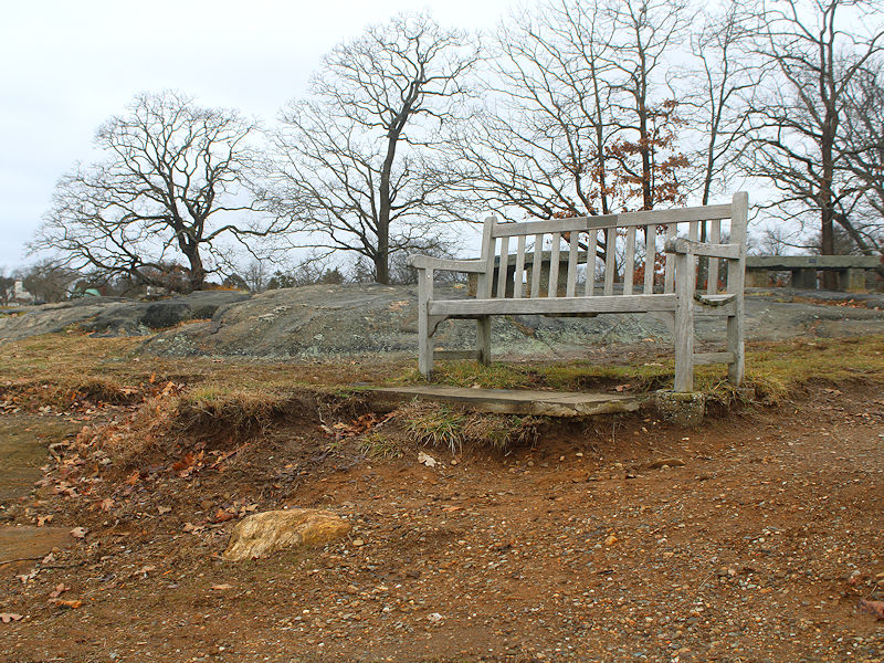
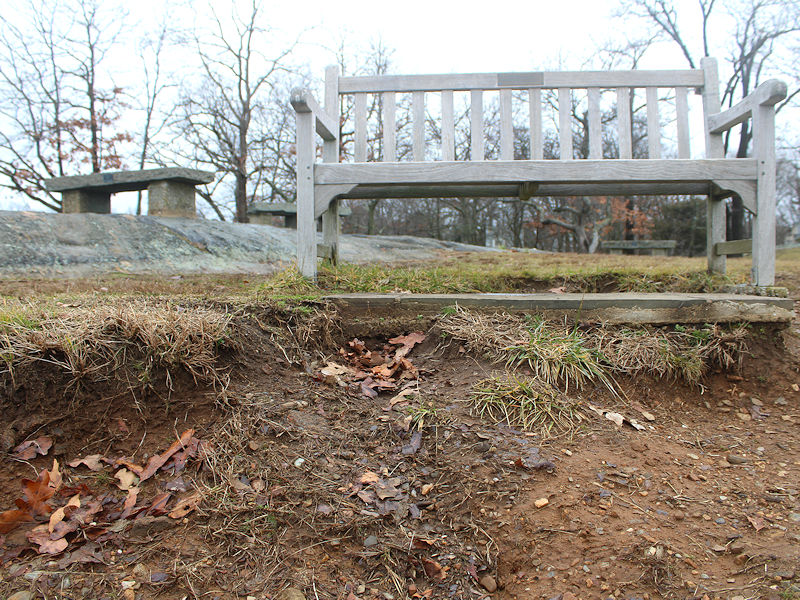
Three photos following the latest rainstorm, which saw a period of gusty winds. The photos reveal the growing erosion as a the waters from a slowly rising along Island Sound increasing come ashore during storms. The pictured bench was once surrounded by grass.
-
JFK's 30-Year rolling average is currently 26.7". JFK has one case of back-to-back winters with < 10" snowfall: 1996-97: 9.8" and 1997-98: 3.6". Prior to those winters, its 30-year average snowfall was 21.2".
-
The mild weather rolls on as the second warmest December and warmest year on record concludes in New York City. 1. The weekly guidance now shows the shift to a cooler, but not cold pattern for the first week of January. The duration could be 1-2 weeks. 2. Consistent with historic experience following cases where the Arctic Oscillation (AO) reached +3.000 or above during December 15-25, no big snowfalls are likely through at least January 10. The biggest snowfall for such cases was 6.4" in during winter January 2013-14. 3. The forthcoming sudden stratospheric warming event (SSWE) is looking less likely to be a major event. But its impact, even if a major event occurs, would not be instantaneous. It typically takes 2-4 weeks for its propagation into and through the troposphere begin to influence the hemispheric weather patterns. Its peak influence is mainly being felt 30-45 days after the event. Such events can trigger or reinforce Atlantic blocking. They do not provide anything close to guarantees of severe cold or major snowstorms. 4. That the models have diverged from strong consensus that had favored a major warming event and splitting of the polar vortex isn't too surprising. Such events are still not well understood. Over the medium and extended range, forecasting skill remains low. 5. Strong El Niño winters are typically "backloaded." Most of the seasonal snowfall falls January 16 or later in the New York City area. Those with the most pessimistic view might argue that 75% of 0.0" is still 0.0". 6. New York City has never seen two consecutive winters with less than 10" of snow since regular recordkeeping began in 1869. Such cases typically begin to appear when average seasonal snowfall declines below 25.0" (not the case for NYC at present). They remain relatively infrequent when seasonal snowfall falls to between 15.0" and 19.9" and but become relatively frequent once seasonal snowfall declines below 15.0". Considering the data from Allentown, Atlantic City, Baltimore, Boston, Bridgeport, Islip, New York City, Newark, Philadelphia, Richmond, and Washington, DC, there is no record of such occurrences when the seasonal snowfall was 25.0" or above. But with the larger climate context shifting, one can't completely rule out such a case for New York City as extremes increase in non-linear fashion, even as such an outcome remains unlikely. One will likely begin to see such occurrences later in the 2030s and beyond as seasonal snowfall declines toward 20" by the mid-2030s and then below it afterward as winters continue to warm. The last such period with seasonal snowfall declining below 25.0" (the 1990s) had some "near misses." In sum, Winter 2023-24 appears to remain on a trajectory that will result in an overall warm anomaly. Snowfall could be below normal but taking into consideration ENSO climatology, it is premature to assume another almost snowless winter is locked in stone.