donsutherland1
-
Posts
23,765 -
Joined
Content Type
Profiles
Blogs
Forums
American Weather
Media Demo
Store
Gallery
Everything posted by donsutherland1
-
The 1970-85 storm tracks might result in more snowfall than during that period, as warmer air holds more moisture and it would be sufficiently cold for snow.
-
My guess is that the seasonal average will fall to about 20” by the mid-2030s. The norm won’t fall to 10” anytime soon. There will still be big storms and snowy winters.
-
The background warming is part of the longer term evolution of seasonal snowfall. Even there, there will continue to be some snowy winters. Bad tracks and sustained warmth have all contributed to this year's outcome. Had the intense snow band from Saturday been 30-40 miles farther north, the current seasonal total would probably be around 15"-20".
-
No. There was a colder more stable temperature regime. A natural cycle and increasing background warming are involved this time around. Already, areas further south in the Mid-Atlantic region have seen a long-term decline in seasonal snowfall. NYC's winters are nearing thresholds where the transitions took place farther south. In terms of winter warmth, nothing has compared to the 2000s. The current winter will likely see yet another mean temperature of 40 or above. Prior to the 2000s the only such winter occurred in 1931-32. There have been five winters with such warmth in the 2000s. Winters 2022-23 and 2023-24 will become the first case of two consecutive winters with a mean temperature of 40 or above. Such warmth typically results in fewer opportunities for snowfall. Absent big storms, snowfall totals wind up lower.
-
Yes. NYC is likely in the early stages of a transition to lower seasonal snowfall.
-
Toronto has an amazingly long record.
-
Today is Charlotte's 750th consecutive day without any snow. Unless things change, the record of 778 days could be broken.
-
LaGuardia: October 1939 Newark: January 1893
-
There were two 100-degree days during summer 1948 at what is now JFK Airport (both in August).
-
Storm tracks also differed. However, the background climate was quite a bit colder then than it is now. In addition, the kind of marine heatwaves that skewed the overall patterns this winter were far less common at that time.
-
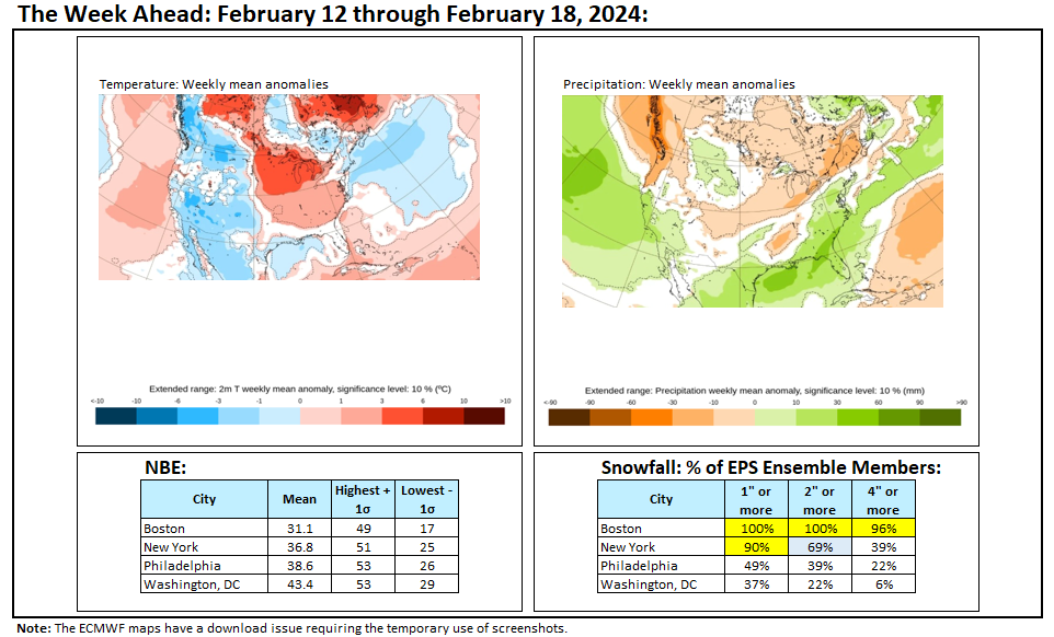
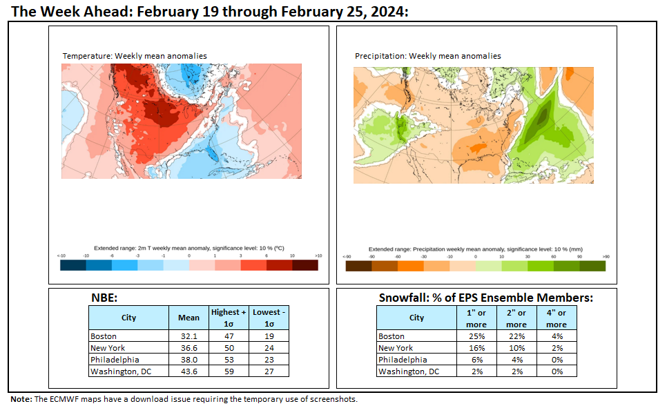
A cooler pattern remains in place. This will not be an especially cold pattern, but it will be noticeably colder than the pattern that defined the first 10 days of the month. Milder weather will likely begin to overspread the region by the middle of the week. Aside from a brief push of cooler air next weekend, temperatures should remain generally above normal once the milder pattern develops. The potential exists for the closing days of February to wind up much warmer than normal. The ENSO Region 1+2 anomaly was +1.2°C and the Region 3.4 anomaly was +1.7°C for the week centered around February 7. For the past six weeks, the ENSO Region 1+2 anomaly has averaged +0.93°C and the ENSO Region 3.4 anomaly has averaged +1.62°C. A basinwide El Niño event is ongoing. The ongoing El Niño event will continue to fade through much of February. The SOI was -3.99 today. The preliminary Arctic Oscillation (AO) was +0.340 today. On February 16 the MJO was in Phase 7 at an amplitude of 1.278 (RMM). The February 15-adjusted amplitude was 1.680 (RMM). Based on sensitivity analysis applied to the latest guidance, there is an implied 95% probability that New York City will have a warmer than normal February (1991-2020 normal). February will likely finish with a mean temperature near 39.3° (3.4° above normal). Winter 2023-2024 is on course to finish with a seasonal mean temperature of 40.1°-40.7°. That would rank the current winter among the ten warmest on record in New York City. It would also mark the second time when two consecutive winters have ranked among the top ten in terms of warmth. Winters 2015-2016 and 2016-2017 are currently the only two such winters to rank among the ten warmest on record. The probability that Winter 2023-2024 will have a mean temperature of 40.0° or above has increased in recent days. Should Winter 2023-2024 finish with a mean temperature of 40.0° or above, that would be the first time on record that New York City has seen two consecutive winters with such warmth.
-
Here's a table of accumulations:
-
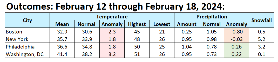
Final numbers for February 12-18, 2024.

-
I agree. The one big difference is that this winter has not seen a big Southeast snowstorm unlike 1972-73.
-
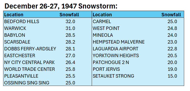
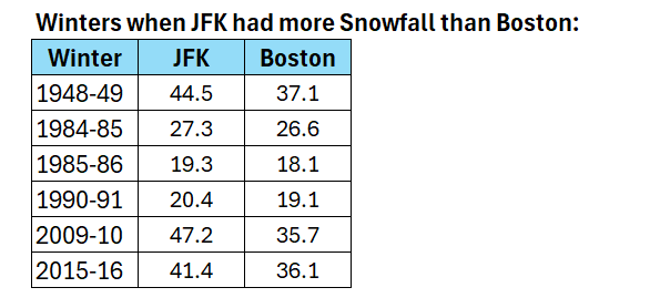
JFK's records go back to July 1948. JFK picked up 18.0" on December 19, 1948. LaGuardia is the only location in Queens that covers 1947-48. Seasonal snowfall there was 63.6". 22.8" fell there during the December 26-27, 1947 snowstorm.
-
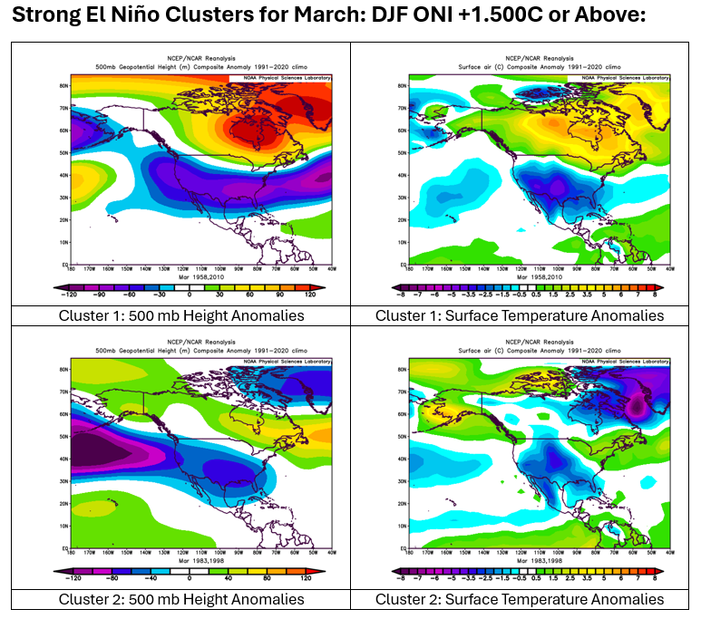
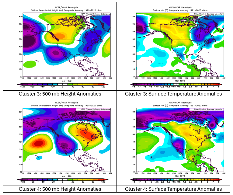
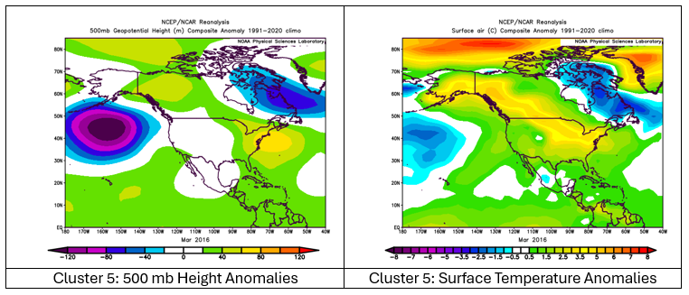
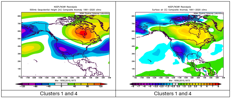
For reference: March clusters based on cases with an average ONI of +1.500C or above for December-February: The CFSv2 currently favors a warmer version of Cluster 1. The single case with a negative PDO was March 1973 (Cluster 4).
-
It's actually happened a number of times.
-
Boston: 9.7"; Philadelphia: 11.2"
-
Week ahead numbers: There are only low prospects of snowfall in the I-95 Corridor. The national blend of models is warmer than the ECMWF weeklies.
-
No. It was a neutral ENSO winter.
-
Numerous strong El Niño events have seen snow in March and have turned colder for a time in the leadup to mid-March (generally weeks 2 through 3). Of course, there's no guarantee that the upcoming March will evolve in such fashion though the monthly guidance hints at an almost canonical ENSO map.
-
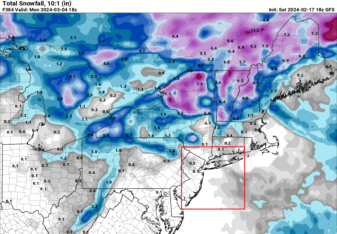
It is. And if the GFS is right, there could be few opportunities possibly through the remainder of this month. Some ensemble members provide some opportunities. The ECMWF and CFS2 weeklies favor very mild readings as February concludes, so next weekend might be the last chance for awhile. The probability of the weekend event producing accumulating snow in Central Park has fallen over the past day of guidance, but skill is still fairly low at the timeframe involved. 2/17 18z GFS:

-
Allentown: 5.7" (much more south of the City) Philadelphia: 2.3" Mount Pocono had 3.1" as of 7 am, but I'm not sure if that will be the final figure. New York City locations: Central Park: 2.0" (season total: 7.5") JFK Airport: 6.2" (season total: 12.8") LaGuardia Airport: 3.3" (season total: 10.5:)
-
An energetic clipper system brought light to moderate snow across the region, along with a narrow band of very heavy snow. Accumulations included: Baltimore: 0.1" Holland Twp, NJ: 13.0" Islip: 3.4" Macungie, PA: 14.8" New Brunswick, NJ: 11.0" New York City-Central Park: 2.0" New York City-JFK Airport: 6.2" New York City-LaGuardia Airport: 3.3" Newark: 4.2" Readington, NJ: 12.0" Washington, DC: 0.1" A cooler pattern remains in place. This will not be an especially cold pattern, but it will be noticeably colder than the pattern that defined the first 10 days of the month. Milder weather will likely begin to overspread the region early next week. The potential exists for the closing days of February to wind up much warmer than normal. The ENSO Region 1+2 anomaly was +1.2°C and the Region 3.4 anomaly was +1.7°C for the week centered around February 7. For the past six weeks, the ENSO Region 1+2 anomaly has averaged +0.93°C and the ENSO Region 3.4 anomaly has averaged +1.62°C. A basinwide El Niño event is ongoing. The ongoing El Niño event will continue to fade through much of February. The SOI was -4.56 today. The preliminary Arctic Oscillation (AO) was -0.825 today. On February 15 the MJO was in Phase 7 at an amplitude of 1.680 (RMM). The February 14-adjusted amplitude was 1.990 (RMM). Based on sensitivity analysis applied to the latest guidance, there is an implied 92% probability that New York City will have a warmer than normal February (1991-2020 normal). February will likely finish with a mean temperature near 39.0° (3.1° above normal). Winter 2023-2024 is on course to finish with a seasonal mean temperature of 40.0°-40.6°. That would rank the current winter among the ten warmest on record in New York City. It would also mark the second time when two consecutive winters have ranked among the top ten in terms of warmth. Winters 2015-2016 and 2016-2017 are currently the only two such winters to rank among the ten warmest on record. The probability that Winter 2023-2024 will have a mean temperature of 40.0° or above has increased in recent days. Should Winter 2023-2024 finish with a mean temperature of 40.0° or above, that would be the first time on record that New York City has seen two consecutive winters with such warmth.
-
Macungie, PA: 14.8”