donsutherland1
-
Posts
23,743 -
Joined
Content Type
Profiles
Blogs
Forums
American Weather
Media Demo
Store
Gallery
Everything posted by donsutherland1
-
2025-2026 ENSO
donsutherland1 replied to 40/70 Benchmark's topic in Weather Forecasting and Discussion
With shortening wave lengths, it actually becomes better for snowfall in the East than a PNA+. -
2025-2026 ENSO
donsutherland1 replied to 40/70 Benchmark's topic in Weather Forecasting and Discussion
There's no question that the PNA+ regime is ending. The ECMWF weeklies keep the PNA negative through the duration of their forecast period.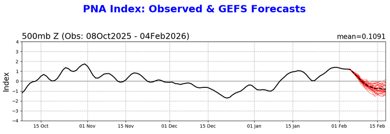
-
February 2026 OBS & Discussion
donsutherland1 replied to Stormlover74's topic in New York City Metro
Colder air will move back into the region tonight. As a result, tomorrow and Friday will see highs in the upper 20s and lows in the teens. An even stronger surge of Arctic air will likely arrive for the weekend, possibly accompanied by some snow flurries or snow showers. Some areas could pick up a heavier snow squall. Highs on Sunday could be in the teens in New York City with lows in the single digits. The persistent and often severely cold pattern could break near February 10th. However, exceptional warmth appears unlikely through at least mid-February. So far, January 20-February 2 has been the coldest two-week period this winter with a mean temperature of 21.0° in New York city. January 17-30 with 13.4" of snow has been the snowiest two-week stretch. The ENSO Region 1+2 anomaly was +0.1°C and the Region 3.4 anomaly was -0.4°C for the week centered around January 28. For the past six weeks, the ENSO Region 1+2 anomaly has averaged -0.38°C and the ENSO Region 3.4 anomaly has averaged -0.57°C. La Niña conditions will likely continue into at least late winter. The SOI was +31.22 today. The preliminary Arctic Oscillation (AO) was -3.454 today. -
February 2026 OBS & Discussion
donsutherland1 replied to Stormlover74's topic in New York City Metro
I've done the Coney Island polar plunge a few times. -
2025-2026 ENSO
donsutherland1 replied to 40/70 Benchmark's topic in Weather Forecasting and Discussion
Ray, Don't let the unnecessary jab affect you. Your work, effort to continually learn and improve, and you are highly respected here. People who are insecure often try to shield themselves from their own shortcomings by seizing on and exaggerating the real or perceived flaws, mistakes, and missteps of others. It is a deeply counterproductive approach, especially when it comes to people skills. Success in almost any environment depends on strong interpersonal abilities. Leaders and entrepreneurs succeed, because they can effectively appeal to people in promoting their vision, ideas, products, and services. Without good interpersonal skills, even considerable talent (and he certainly has it) is unlikely to be fully realized or effectively leveraged. -
MAX 17F ... MIN 6F ... SNOW 0.2"
-
2025-2026 ENSO
donsutherland1 replied to 40/70 Benchmark's topic in Weather Forecasting and Discussion
Yes. That's due to shortening wave lengths. EPO becomes relatively more important. -
February 2026 OBS & Discussion
donsutherland1 replied to Stormlover74's topic in New York City Metro
Tomorrow will be another relatively mild day. Highs will likely top out in the lower to perhaps middle 30s. A few flurries are possible as a weak system drags a cold front across the region. Colder air will then return on Thursday. An even stronger surge of Arctic air could arrive for the weekend, possibly accompanied by some snow flurries or snow showers. Highs both Saturday and Sunday could be in the teens in New York City. The last time there were two or more consecutive such highs was during January 5-7, 2018. The persistent and often severely cold pattern could break near February 10th. Overall, January 20th-February 3rd will likely be the coldest and perhaps snowiest two-week period this winter. The forecast WPO-/EPO-/AO-/PNA+ pattern is typically the coldest pattern in January and among the coldest during the first half of February. A persistently positive PNA will have above climatological risk of moderate or significant snowfalls. For perspective, the coldest two-week period this winter prior to January 20th was January 3-16, 2026 and January 4-17, 2026 with a mean temperature of 30.3°. The snowiest two-week period was December 14-27, 2025 when 7.2" of snow fell. Already, snowfall since January 20th has surpassed that figure. The ENSO Region 1+2 anomaly was +0.1°C and the Region 3.4 anomaly was -0.4°C for the week centered around January 28. For the past six weeks, the ENSO Region 1+2 anomaly has averaged -0.38°C and the ENSO Region 3.4 anomaly has averaged -0.57°C. La Niña conditions will likely continue into at least late winter. The SOI was +24.06 today. The preliminary Arctic Oscillation (AO) was -3.750 today. -
February 2026 OBS & Discussion
donsutherland1 replied to Stormlover74's topic in New York City Metro
2015 is prominently featured in the coldest 30-day periods in terms of minimum temperatures: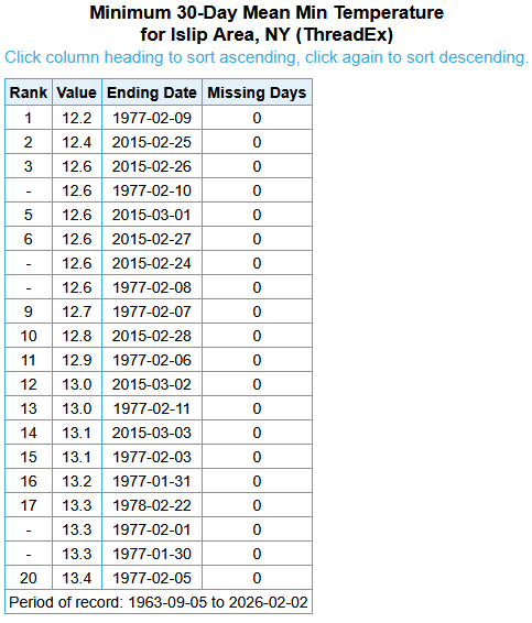
-
February 2026 OBS & Discussion
donsutherland1 replied to Stormlover74's topic in New York City Metro
Through today, cumulative snow depth is 83” in NYC. That’s the highest since 2015-16. -
February 2026 OBS & Discussion
donsutherland1 replied to Stormlover74's topic in New York City Metro
Newark had a high of -1 on January 10, 1859. -
February 2026 OBS & Discussion
donsutherland1 replied to Stormlover74's topic in New York City Metro
For NYC, only 2002 and 2020 had no measurable snowfall for February 1-March 31. -
February 2026 OBS & Discussion
donsutherland1 replied to Stormlover74's topic in New York City Metro
1887-88 is ahead mainly because it was several degrees colder through January even as it had slightly less snowfall than the current winter. -
2025-2026 ENSO
donsutherland1 replied to 40/70 Benchmark's topic in Weather Forecasting and Discussion
Ray has done an awesome job so far. Statistically, a cold March seems less likely, but it's still in play. I think March's outcome depends on whether the modeled SSWE can occur and, if so, whether it can propagate in a favorable fashion. If not, even if March starts cool, things could quickly break to the warm side. New England would probably hold onto the cold longer than the Mid-Atlantic. A strong EPO-/AO- pattern would probably be needed to deliver a 2018-style outcome. At this stage, the WPO becomes less important due to the shorter wave lengths. -
February 2026 OBS & Discussion
donsutherland1 replied to Stormlover74's topic in New York City Metro
Temperatures have begun to moderate. In New York City, the temperature broke above freezing for the first time since January 23. That was the longest such stretch since Winter 2017-2018. Tomorrow and Wednesday will likely see highs in the lower to perhaps middle 30s. A few flurries are possible on Wednesday as a weak system drags a cold front across the region. Colder air will then return on Thursday. An even stronger surge of Arctic air could arrive for the weekend, possibly accompanied by some snow flurries or snow showers. The persistent and often severely cold pattern could break near February 10th. Overall, January 20th-February 3rd will likely be the coldest and perhaps snowiest two-week period this winter. The forecast WPO-/EPO-/AO-/PNA+ pattern is typically the coldest pattern in January and among the coldest during the first half of February. A persistently positive PNA will have above climatological risk of moderate or significant snowfalls. For perspective, the coldest two-week period this winter prior to January 20th was January 3-16, 2026 and January 4-17, 2026 with a mean temperature of 30.3°. The snowiest two-week period was December 14-27, 2025 when 7.2" of snow fell. Already, snowfall since January 20th has surpassed that figure. The ENSO Region 1+2 anomaly was +0.1°C and the Region 3.4 anomaly was -0.4°C for the week centered around January 28. For the past six weeks, the ENSO Region 1+2 anomaly has averaged -0.38°C and the ENSO Region 3.4 anomaly has averaged -0.57°C. La Niña conditions will likely continue into at least late winter. The SOI was +24.02 today. The preliminary Arctic Oscillation (AO) was -3.066 today. -
February 2026 OBS & Discussion
donsutherland1 replied to Stormlover74's topic in New York City Metro
The longest stretch of subfreezing days since 2017-18 ended today. The ECMWF weeklies show a distinct milder period of 1-2 weeks duration. Social media is suddenly abuzz about the warmth it has noticed. Still, there's no need to despair. Winter 2025-2026 has already delivered some genuinely great moments. Although those moments might be in the past, they cannot be erased by the forecast moderation that lies ahead beginning around February 10th. Some highlights: New York City experienced its coldest December-January period since 2014-2015. New York City saw an 11.4" snowfall with many areas outside the City picking up 12"-18". New York City has seen two highs in the teens and two lows in the single digits. Outside the City, numerous locations have experienced subzero lows. Ice and ice floes have reappeared in the Hudson River for the first time in years. In a wider perspective, parts of the Great Lakes Region saw a record November daily snowfall, Toronto experienced its biggest snowstorm on record, and parts of Georgia, South Carolina, and North Carolina enjoyed a generational snowstorm. Nothing is cast in stone. Model skill beyond two weeks is low. Forecast patterns can change. Sometimes abruptly. IMO, rather than riding an emotional roller-coaster with each turn of the models or allowing the most negative outcomes to drive winter's wonderful moments from memory, it's better to appreciate what we've already experienced and stay patient about what lies ahead. Spring will come. It always does. But Winter 2025-2026 may still bring additional cold and snowfall, even if the models cannot currently see the cold and snow at the long lead times involved. -
2025-2026 ENSO
donsutherland1 replied to 40/70 Benchmark's topic in Weather Forecasting and Discussion
I was referring to the ECMWF weekly maps in general. I prefer the ECMWF chart to vendors. -
February 2026 OBS & Discussion
donsutherland1 replied to Stormlover74's topic in New York City Metro
I went to Cape May for the storm. There were near whiteout conditions. -
2025-2026 ENSO
donsutherland1 replied to 40/70 Benchmark's topic in Weather Forecasting and Discussion
Yes, they're definitely a step back (continuing the trend from recent days). I actually prefer the daily data, as one can better evaluate what's happening than if one had to make guesses over 3- and 4-day intervals. -
2025-2026 ENSO
donsutherland1 replied to 40/70 Benchmark's topic in Weather Forecasting and Discussion
February 2015 had exceptional warmth in the western third of the CONUS. -
2025-2026 ENSO
donsutherland1 replied to 40/70 Benchmark's topic in Weather Forecasting and Discussion
It's impressive, especially when one considers that the cool anomalies over the Atlantic bring down the areal average. My guess is that near record/record warmth could be possible in the Northern Plains and Canadian Prairies. -
2025-2026 ENSO
donsutherland1 replied to 40/70 Benchmark's topic in Weather Forecasting and Discussion
I'm not sure what data was used to for the run-up in the price, much less the plunge. I suspect that the dramatic shift in the CFSv2 started the sell-off. The latest ECWMF weeklies were not yet available. In the larger scheme of things, this was not looking like a Top 3 coldest February since 2010 nationwide. Using AmWx's Top 10 forecasters from 2025, here were the expected February numbers: IMO, that consensus consistently beats most of what is posted on Social Media for long-range ideas, perhaps because there is no incentive to hype for clicks, views, etc. Here are the Top 5 coldest Februaries since 2010: #1: 2021 #2: 2010 #3: 2019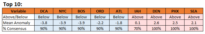
-
February 2026 OBS & Discussion
donsutherland1 replied to Stormlover74's topic in New York City Metro
It's very unlikely. The air mass isn't sufficiently cold. One probably won't have NNW or N winds that are optimal for the strongest cold air advection. -
2025-2026 ENSO
donsutherland1 replied to 40/70 Benchmark's topic in Weather Forecasting and Discussion
IMO, the Wbell anomalies are too cold. If one moves up one category (e.g., -5 to -7 becomes -3 to -5), one will probably be closer to the final values. Having said that, the Northeast will very likely finish below normal. With the expected readings through February 14th, one would need a top 5-10 warm finish just to bring the anomalies to normal. So far, none of the guidance (even the CFSv2) is showing sustained warmth of that magnitude. -
2025-2026 ENSO
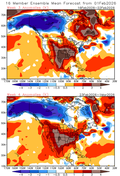
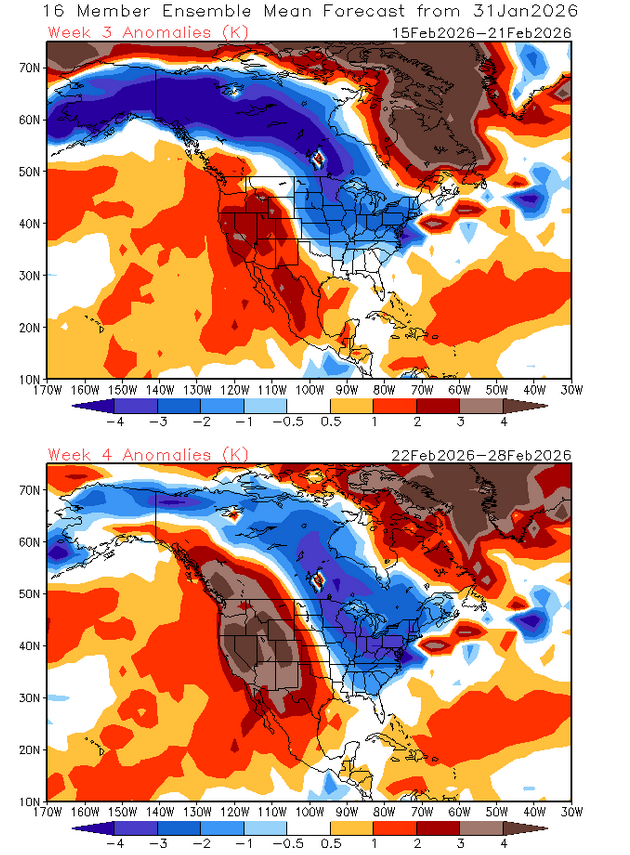
donsutherland1 replied to 40/70 Benchmark's topic in Weather Forecasting and Discussion
The NG market seems to be surfing the CFSv2's long-range outlook. From January 31: From February 1: The moderation starting around the 10th is real. The consistent theme is that the southern and central plains/West will remain generally warmer than normal but there could be a 7-10-day cooler period in the West. Wave lengths will be shortening beyond mid-month, complicating things and enhancing the level of uncertainty. I don't think either a mild or cold outcome in the East beyond let's say February 20th is a slam dunk. I'd still give greater weight to the ECMWF weeklies for a possible return of cooler weather, not necessarily severely cold weather, as there are some hints that the EPO and WPO could go negative sometime after mid-month.