donsutherland1
-
Posts
24,118 -
Joined
Content Type
Profiles
Blogs
Forums
American Weather
Media Demo
Store
Gallery
Everything posted by donsutherland1
-
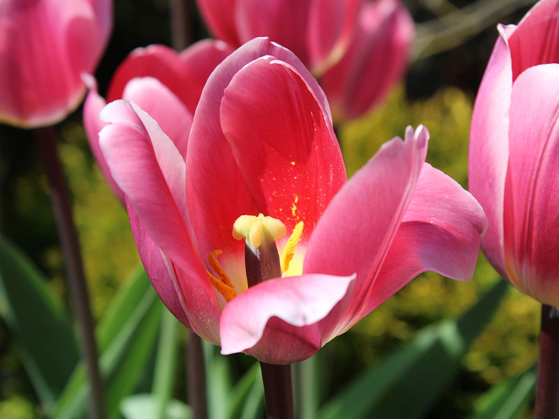
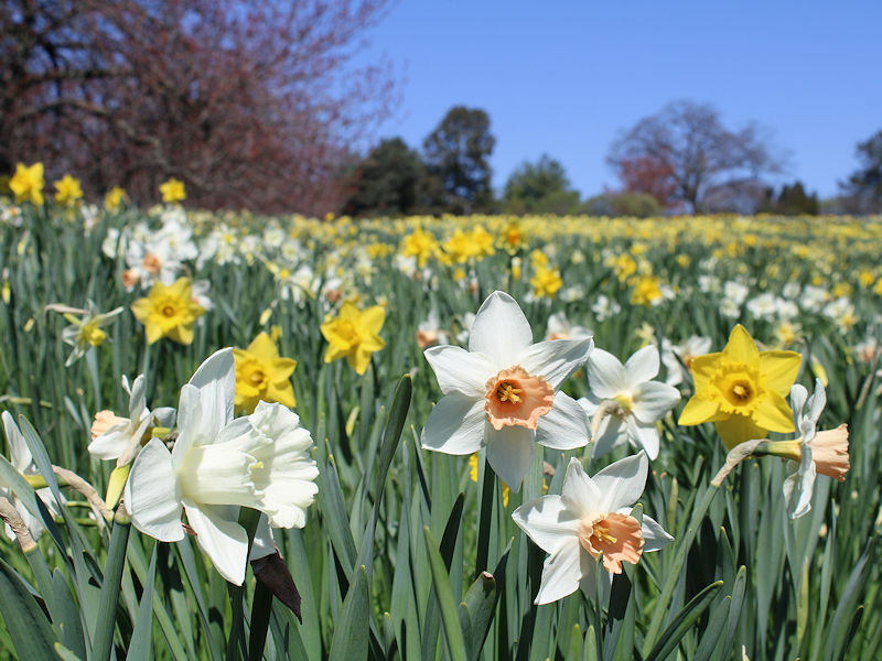
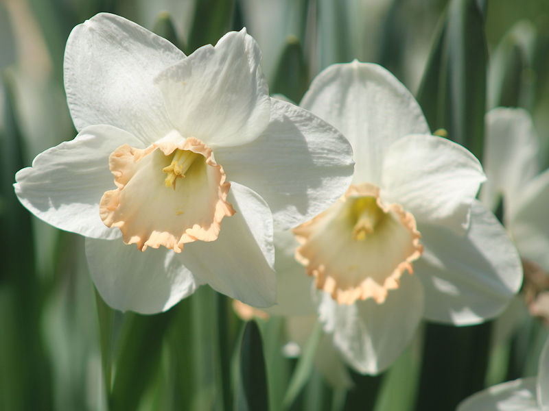
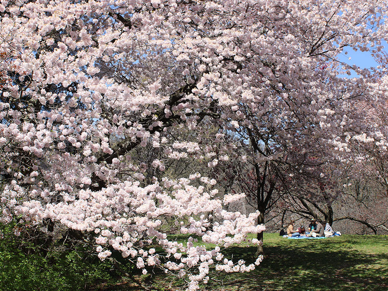
Although readings were confined to the lower and middle 50s, the signs of spring are everywhere. From the New York Botanical Garden:
- 970 replies
-
- 7
-

-
- april showers bring may..
- rain
- (and 2 more)
-
Great observation.
- 970 replies
-
- 1
-
-
- april showers bring may..
- rain
- (and 2 more)
-
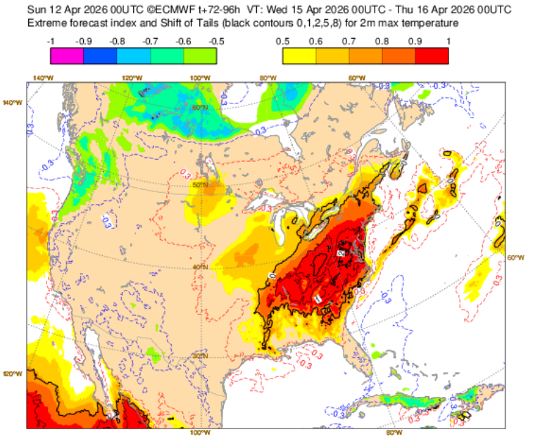
The signal for record heat in the Mid-Atlantic into the New York City area on Wednesday has increased. The latest ECMWF EFI guidance:
- 970 replies
-
- 3
-
-

-
- april showers bring may..
- rain
- (and 2 more)
-
Tomorrow will be a bit cooler with highs in the 50s. Afterward, much warmer weather will develop on Monday. Temperatures will likely peak in the 80s Tuesday through Thursday. No rain is likely through at least next Friday. The ENSO Region 1+2 anomaly was +1.2°C and the Region 3.4 anomaly was +0.2°C for the week centered around April 1. For the past six weeks, the ENSO Region 1+2 anomaly has averaged +1.25°C and the ENSO Region 3.4 anomaly has averaged 0.00°C. Neutral ENSO conditions will continue through at least mid-spring. The SOI was -27.62 today. The preliminary Arctic Oscillation (AO) was +0.933 today. Based on sensitivity analysis applied to the latest guidance, there is an implied near 81% probability that New York City will have a warmer than normal April (1991-2020 normal). April will likely finish with a mean temperature near 56.7° (3.0° above normal). Supplemental Information: The projected mean would be 3.7° above the 1981-2010 normal monthly value.
-
2026-2027 Super El Nino
donsutherland1 replied to Stormchaserchuck1's topic in Weather Forecasting and Discussion
The Newark list is can be found using Newark Airport. I am not sure why it wasn’t added to the Newark area option. -
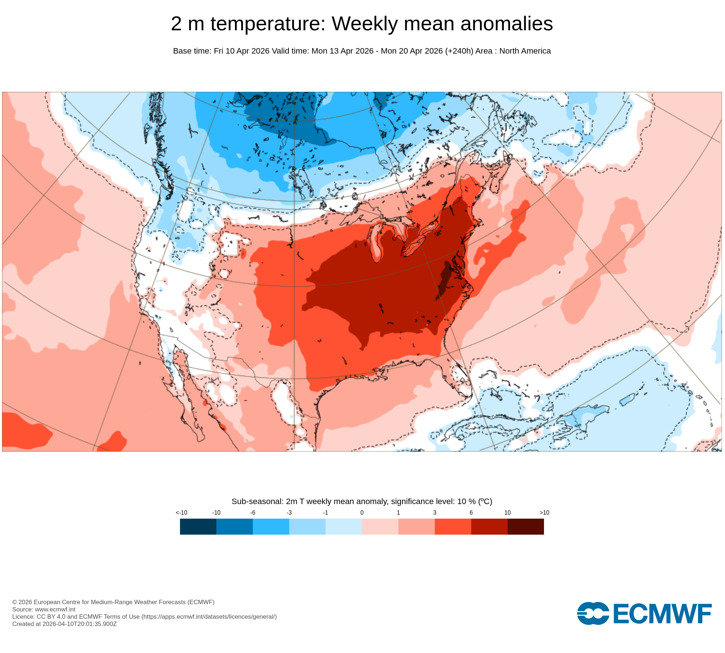
Next week is on course to feature the warmest weather so far this season. Central Park's April 15th daily record of 87° from 1941 and Newark's daily record of 88° from 1960 could be challenged. Tuesday through Thursday will likely see highs in the 80s in the New York City region. Highs will reach the 70s on Long Island, but Islip could make a run at 80° on Wednesday (daily record: 78°, 2002 and 2024) if the onset of the sea breeze is delayed.
- 970 replies
-
- 3
-
-

-
- april showers bring may..
- rain
- (and 2 more)
-
A warming trend is underway. Temperatures will top out in the 60s tomorrow and then upper 50s on Sunday. It will then turn much warmer next week. Temperatures will likely peak near or above 80° during Tuesday through Thursday. The ENSO Region 1+2 anomaly was +1.2°C and the Region 3.4 anomaly was +0.2°C for the week centered around April 1. For the past six weeks, the ENSO Region 1+2 anomaly has averaged +1.25°C and the ENSO Region 3.4 anomaly has averaged 0.00°C. Neutral ENSO conditions will continue through at least mid-spring. The SOI was -33.53 today. The preliminary Arctic Oscillation (AO) was +2.117 today. Based on sensitivity analysis applied to the latest guidance, there is an implied near 81% probability that New York City will have a warmer than normal April (1991-2020 normal). April will likely finish with a mean temperature near 56.7° (3.0° above normal). Supplemental Information: The projected mean would be 3.7° above the 1981-2010 normal monthly value.
- 970 replies
-
- 1
-
-
- april showers bring may..
- rain
- (and 2 more)
-
A warming trend is commencing. Temperatures will return to the 60s tomorrow. The warmth will extend into the weekend. It could turn even warmer next week with temperatures peaking near or even above 80° during Tuesday through Thursday. The ENSO Region 1+2 anomaly was +1.2°C and the Region 3.4 anomaly was +0.2°C for the week centered around April 1. For the past six weeks, the ENSO Region 1+2 anomaly has averaged +1.25°C and the ENSO Region 3.4 anomaly has averaged 0.00°C. Neutral ENSO conditions will continue through at least mid-spring. The SOI was -32.74 today. The preliminary Arctic Oscillation (AO) was +2.247 today. Based on sensitivity analysis applied to the latest guidance, there is an implied near 79% probability that New York City will have a warmer than normal April (1991-2020 normal). April will likely finish with a mean temperature near 56.5° (2.8° above normal). Supplemental Information: The projected mean would be 3.5° above the 1981-2010 normal monthly value.
- 970 replies
-
- 2
-

-
-
- april showers bring may..
- rain
- (and 2 more)
-
This morning's low temperature in Central Park was 30°. That will likely be the last freeze this season. Temperatures will likely top out in the middle 50s tomorrow. Afterward, it will turn warmer to end the week and start the weekend. Temperatures will return to the 60s on Friday. The warmth will extend into the weekend. It could turn even warmer next week. The ENSO Region 1+2 anomaly was +1.2°C and the Region 3.4 anomaly was +0.2°C for the week centered around April 1. For the past six weeks, the ENSO Region 1+2 anomaly has averaged +1.25°C and the ENSO Region 3.4 anomaly has averaged 0.00°C. Neutral ENSO conditions will continue through at least mid-spring. The SOI was -17.45 today. The preliminary Arctic Oscillation (AO) was +1.494 today. Based on sensitivity analysis applied to the latest guidance, there is an implied near 72% probability that New York City will have a warmer than normal April (1991-2020 normal). April will likely finish with a mean temperature near 56.0° (2.3° above normal). Supplemental Information: The projected mean would be 3.0° above the 1981-2010 normal monthly value.
-
Central Park had a low of 30° this morning. Yesterday, Bridgeport, Islip, and Central Park had identical high and low temperatures (56°-32°). The last time that occurred was December 25, 2022 when all three locations had highs and lows of 28°-14°.
- 970 replies
-
- 1
-
-
- april showers bring may..
- rain
- (and 2 more)
-
Yes. Typos.
-
Cooler conditions have returned to the region. Temperatures will likely top out in the 50s through Thursday. Highs tomorrow will struggle to reach the lower 50s. Tomorrow morning could see the low temperature approach 32° in New York City. Should the mercury reach 32°, New York City would see its second consecutive April with a freeze (last year's last freeze was April 9). The last time that happened was 2015 and 2016. Temperatures will return to the 60s on Friday. The warmth will extend into the weekend. It could turn even warmer next week. The ENSO Region 1+2 anomaly was +1.2°C and the Region 3.4 anomaly was +0.2°C for the week centered around April 1. For the past six weeks, the ENSO Region 1+2 anomaly has averaged +1.25°C and the ENSO Region 3.4 anomaly has averaged 0.00°C. Neutral ENSO conditions will continue through at least mid-spring. The SOI was -9.23 today. The preliminary Arctic Oscillation (AO) was +0.944 today. Based on sensitivity analysis applied to the latest guidance, there is an implied near 66% probability that New York City will have a warmer than normal April (1991-2020 normal). April will likely finish with a mean temperature near 55.5° (1.8° above normal). Supplemental Information: The projected mean would be 2.5° above the 1981-2010 normal monthly value.
-
Cooler conditions have returned to the region. Temperatures will likely top out in the 50s through Thursday. Highs on Tuesday and Wednesday will likely struggle to reach the lower 50s. Wednesday morning could see the low temperature approach 32° in New York City. Should the mercury reach 32°, New York City would see its second consecutive April with a freeze (last year's last freeze was April 9). The last time that happened was 2015 and 2016. Temperatures will return to the 60s on Friday. The warmth will extend into the weekend. The ENSO Region 1+2 anomaly was +1.2°C and the Region 3.4 anomaly was +0.2°C for the week centered around April 1. For the past six weeks, the ENSO Region 1+2 anomaly has averaged +1.25°C and the ENSO Region 3.4 anomaly has averaged 0.00°C. Neutral ENSO conditions will continue through at least mid-spring. The SOI was -7.43 today. The preliminary Arctic Oscillation (AO) was +1.535 today.
-
Central Park, JFK Airport, and LaGuardia Airport had identical low and high temperatures (57°-42°) today. The last time that happened was August 29, 2025 when all three stations had a 78°-65° daily temperature range. That was the only such occurrence last year. The record is 4 occurrences. That record was set in 1959 and tied in 1968 and 1976.
- 970 replies
-
- 4
-
-
- april showers bring may..
- rain
- (and 2 more)
-
Cooler conditions will return to the region tomorrow. Temperatures will likely top out in the 50s through Thursday. Highs on Tuesday and Wednesday will likely struggle to reach the lower 50s. Wednesday morning could see the low temperature approach 32° in New York City. Should the mercury reach 32°, New York City would see its second consecutive April with a freeze (last year's last freeze was April 9). The last time that happened was 2015 and 2016. Temperatures will return to the 60s on Friday. The warmth will extend into the weekend. The ENSO Region 1+2 anomaly was +1.3°C and the Region 3.4 anomaly was +0.2°C for the week centered around March 25. For the past six weeks, the ENSO Region 1+2 anomaly has averaged +1.25°C and the ENSO Region 3.4 anomaly has averaged -0.02°C. Neutral ENSO conditions will continue through at least mid-spring. The SOI was -7.79 today. The preliminary Arctic Oscillation (AO) was +2.006 today.
-
Some showers are possible tonight into tomorrow. Tomorrow will remain mild with highs in the middle and upper 60s. A cold front that will bring showers or a thundershower tomorrow afternoon or evening will result in cooler conditions returning to the region on Monday. Temperatures through midweek will likely top out in the 50s. The coolest weather is likely on Wednesday when the low could approach 32° in New York City. If so, New York City could see its second consecutive April with a freeze (last year's last freeze was April 9). The last time that happened was 2015 and 2016. The ENSO Region 1+2 anomaly was +1.3°C and the Region 3.4 anomaly was +0.2°C for the week centered around March 25. For the past six weeks, the ENSO Region 1+2 anomaly has averaged +1.25°C and the ENSO Region 3.4 anomaly has averaged -0.02°C. Neutral ENSO conditions will continue through at least mid-spring. The SOI was -4.90 today. The preliminary Arctic Oscillation (AO) was +2.054 today.
- 970 replies
-
- 1
-
-
- april showers bring may..
- rain
- (and 2 more)
-
The 12z NBM is a little cooler (32°).
-
April 10, 1997: 28°
-
DCA: +3.8 NYC: +2.7 BOS: +2.5 ORD: +3.9 ATL: +5.2 IAH: +3.5 DEN: +2.0 PHX: +2.0 SEA: +0.3
-
Will do.
-
Tomorrow and Sunday will remain mild with highs in the middle and upper 60s. Some spots could reach 70° or a little warmer. However, a cold front that will bring showers or a thundershower late Sunday or Sunday night will result in cooler conditions returning to the region on Monday. Temperatures through midweek will likely top out in the 50s. The ENSO Region 1+2 anomaly was +1.3°C and the Region 3.4 anomaly was +0.2°C for the week centered around March 25. For the past six weeks, the ENSO Region 1+2 anomaly has averaged +1.25°C and the ENSO Region 3.4 anomaly has averaged -0.02°C. Neutral ENSO conditions will continue through at least mid-spring. The SOI was -4.90 today. The preliminary Arctic Oscillation (AO) was +1.917 today.
- 970 replies
-
- 1
-
-
- april showers bring may..
- rain
- (and 2 more)
-
It will turn noticeably warmer tomorrow with highs in the upper 60s to perhaps 70°. Friday should feature highs near or just above 70°. Sunday will remain mild with highs in the middle and upper 60s. However, a cold front will result in cooler conditions returning to the region on Monday. Temperatures through midweek will likely top out in the 50s. The ENSO Region 1+2 anomaly was +1.3°C and the Region 3.4 anomaly was +0.2°C for the week centered around March 25. For the past six weeks, the ENSO Region 1+2 anomaly has averaged +1.25°C and the ENSO Region 3.4 anomaly has averaged -0.02°C. Neutral ENSO conditions will continue through at least mid-spring. The SOI was -8.37 today. The preliminary Arctic Oscillation (AO) was +1.999 today.
- 970 replies
-
- 1
-
-
- april showers bring may..
- rain
- (and 2 more)
-
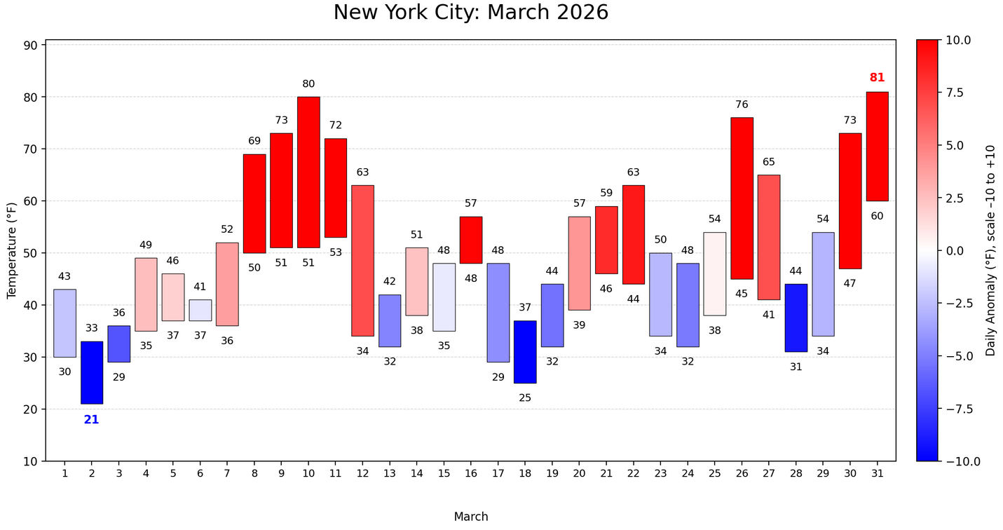
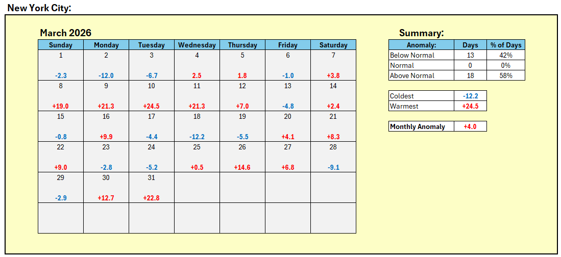
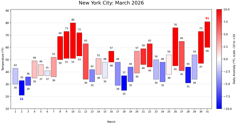
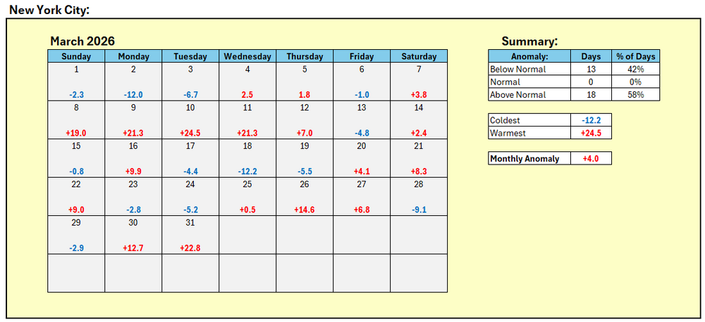
New York City finished March with a monthly mean temperature of 46.8°. That was 4.0° above normal and 4.3° above the earlier 1981-2020 baseline.
-
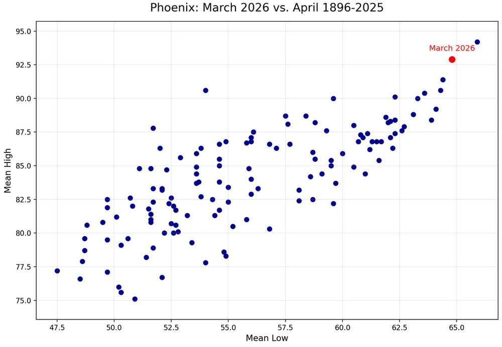
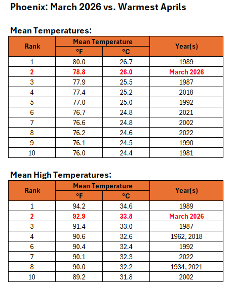
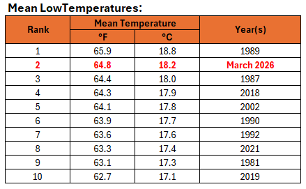
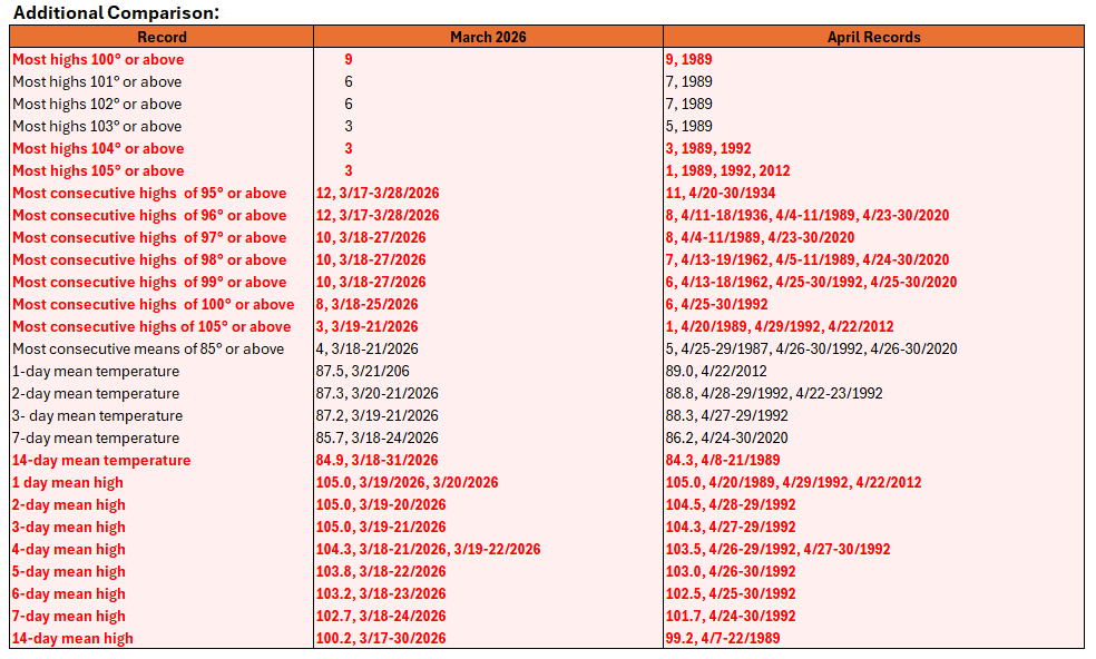
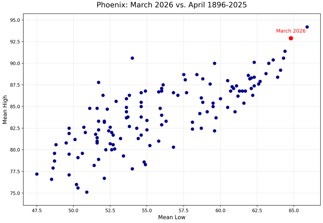
Phoenix was so warm during March 2026 that its mean monthly low, mean monthly high, and mean monthly temperatures would all have ranked second hottest on record for April. Numerous March temperature records surpassed the most extreme values experienced during April.