-
Posts
23,911 -
Joined
Content Type
Profiles
Blogs
Forums
American Weather
Media Demo
Store
Gallery
Everything posted by donsutherland1
-
Yes. That's correct. The snow could be falling or blowing.
-
Yes, but the temperature criterion was eliminated.
-
From here: https://sites.gsl.noaa.gov/desi/
-
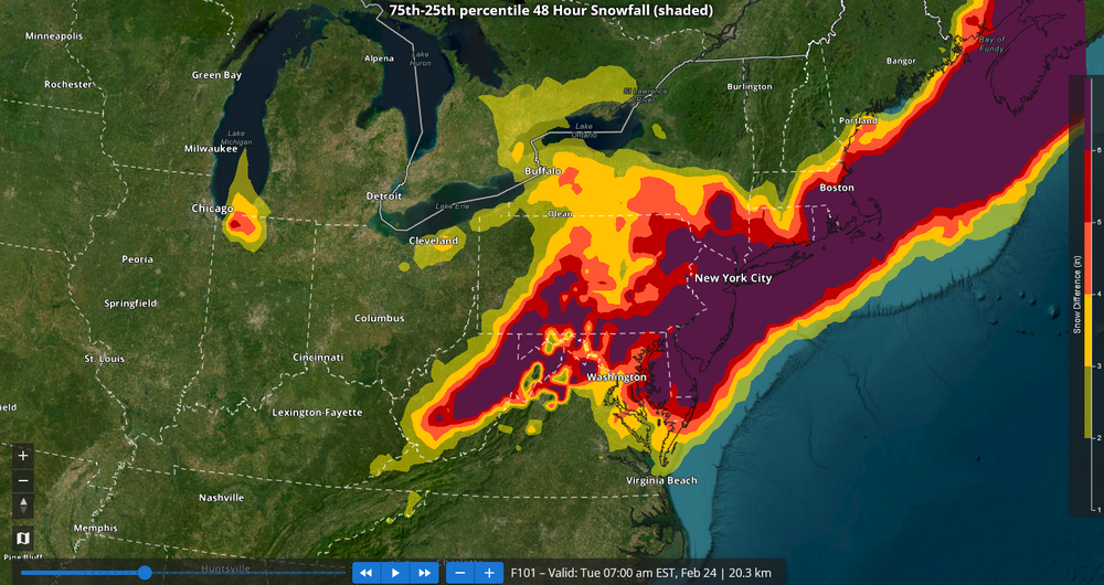
This system has more latitude to come farther north than the 2/6/2010 blizzard had, though there's a limit to how far north it will come. It will depend on the timing and location of phasing and the timing when the trough goes neutral/negative. I suspect 50 miles is within the realm of possibility, as underscored by spreads between the 25th/75th percentile outcomes. In 2010, there was an overwhelming block that precluded the storm's gaining latitude (AO: -5.205; NAO: -0.985) and locked strong confluence into place. In any case, the area of heaviest snows will probably be focused somewhere from the northern Delmarva across central/southern New Jersey barring some large changes. But it is plausible that warning-level snows could extend into northwest New Jersey/adjacent northeast Pennsylvania, NYC's northern/western suburbs, and the southern half of Connecticut.
-
The issue with the idea of posting blizzard warnings later today was that the lead time is too long. Blizzard warnings are only posted when blizzard conditions are ongoing or imminent in the next 12-18 hours.
-
No. Even if a blizzard is likely, the criteria do not allow for a blizzard warning at the lead time involved. A Blizzard Warning means that the following conditions are occurring or expected within the next 12 to 18 hours. 1) Snow and/or blowing snow reducing visibility to 1/4 mile or less for 3 hours or longer AND 2) Sustained winds of 35 mph or greater or frequent gusts to 35 mph or greater. There is no temperature requirement that must be met to achieve blizzard conditions. https://www.weather.gov/lwx/warningsdefined#Blizzard Warning
-
We agree about the NAM. I mentioned it just for purposes of reference. I give it very little weight at this timeframe and I'm looking forward to its retirement. I started somewhat conservatively, as there is enormous spread among the guidance and among the NBM's 25th/75th percentiles and 10th/90th percentiles. Hopefully, the spread will be smaller after the 12z and 18z cycles. I'll revisit the numbers late in the day. Finally, as you note, 4"-8" might also be a better initial call.
-
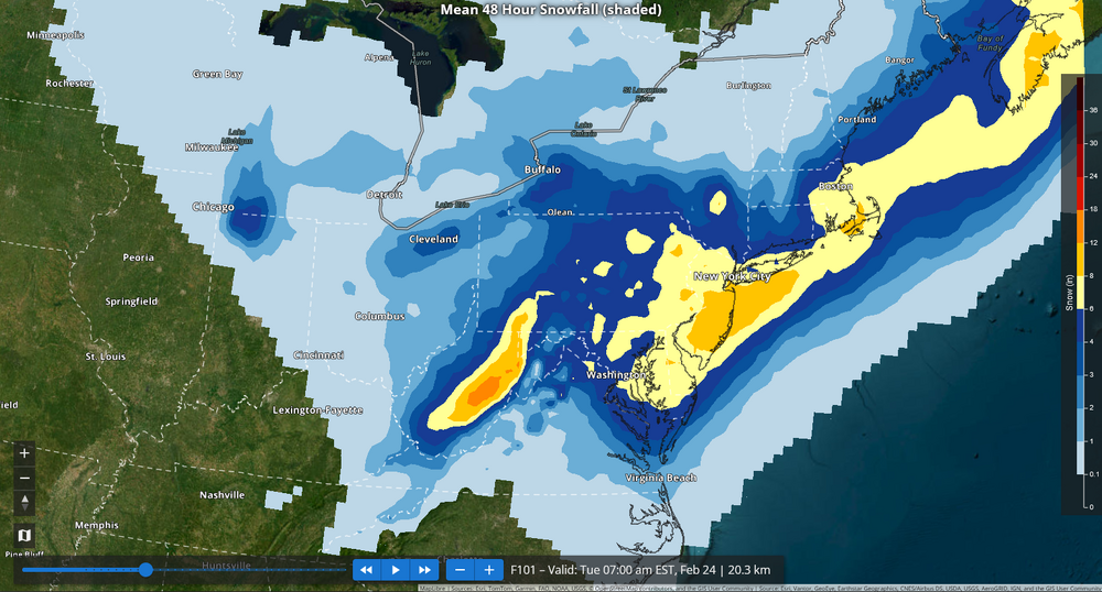
For reference, here are the 7z NBM numbers, including the spread between the 25th and 75th percentiles: Snowfall: Spread: A large area, including the New York City region has a 6" or above spread. In short, big changes are still possible.
-
Last night had some favorable developments. Although a significant or major snowstorm remains a low probability/high-impact scenario, there was a notable increase in EPS members supporting such a solution. 6" or above: 2/19 12z: 8%; 2/20 0z: 24% 10" or above: 2/19 12z: 0%; 2/20 0z: 12% Model disagreement, especially at the surface, persists. The GFS remains the most aggressive model. The NAM shows no accumulating snow in New York City. Things should start to narrow today. A good starting point might be a 3"-6"-type snowfall for New York City and its nearby suburbs with more than 6" likely in an area running from central/southern New Jersey northeastward across central and eastern Long Island. These numbers are subject to change as the situation remains dynamic.
-
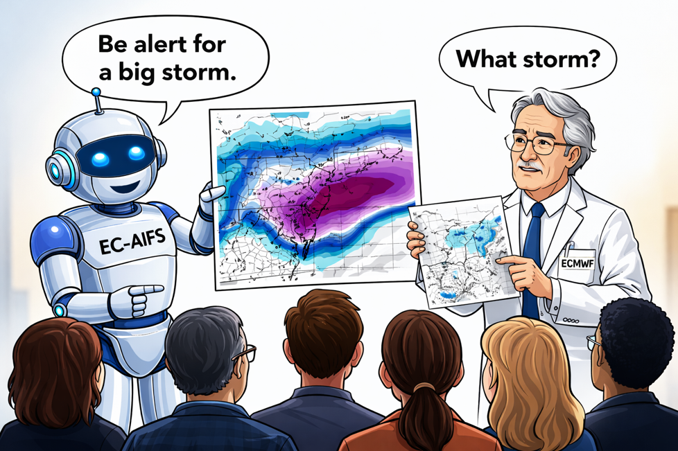
The 18z ECMWF-AIFS has thrown a lifeline to the GFS. Overall, a much snowier run.
-
Not at 18z.
-

February 2026 OBS & Discussion
donsutherland1 replied to Stormlover74's topic in New York City Metro
Another round of rain will arrive tonight and could continue into early Saturday. Most of the region will see less than 0.50" of rain. Highs will likely reach the lower 40s through Saturday. Another storm could bring some snow to parts of the region Sunday into Monday, but there remains some uncertainty about its track and impacts. A significant or major snowstorm remains a low probability, high-impact event. Currently, the GFS is the only operational model supporting this solution. No individual EPS member shows 10" or more snowfall and just 8% have 6" or more. The ENSO Region 1+2 anomaly was +0.7°C and the Region 3.4 anomaly was -0.2°C for the week centered around February 11. For the past six weeks, the ENSO Region 1+2 anomaly has averaged -0.03°C and the ENSO Region 3.4 anomaly has averaged -0.47°C. Neutral ENSO conditions are now developing. Neutral ENSO conditions will develop during the close of winter. The SOI was +0.48 today. The preliminary Arctic Oscillation (AO) was -0.065 today. Based on sensitivity analysis applied to the latest guidance, there is an implied near 99% probability that New York City will have a cooler than normal February (1991-2020 normal). February will likely finish with a mean temperature near 31.8° (4.1° below normal). Supplemental Information: The projected mean would be 3.5 below the 1981-2010 normal monthly value. Overall, Winter 2025-2026 is on track for a seasonal mean temperature of 32.0°, but the forecast development of an AO+ regime could lead to a sufficiently mild outcome to result in a winter mean temperature that exceeds freezing. If a 32.0° or below seasonal mean temperature occurs, that would be the lowest winter mean temperature since Winter 2014-2015 when the mean temperature was 31.7°. Winter 2025-2026 would only become the fourth winter of the 21st century with a mean temperature of 32.0° or below. -
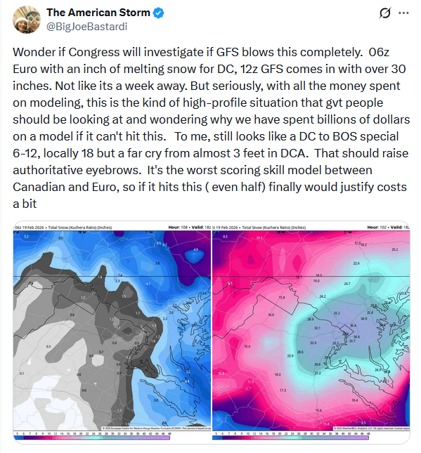
Here's his tweet on the storm: I don't disagree with his sentiments concerning the GFS. It remains perplexing that when it came to the last major upgrade of the GFS, NCEP did not adopt the top-flight 4dVAR initialization scheme that is used by the ECMWF, GGEM, and UKMET. Weaker initialization puts the model at a disadvantage from the start. Occasionally, the model scores, but far more often than not, other models provide better solutions. Finally, a significant or major hit has been a low probability, high-impact scenario. Unfortunately, as the lead time has diminished the overall probability of such an outcome has not increased. If anything, it has decreased. There's still uncertainty, but time is running out.
-
It could be worse. Consider the last four months in Phoenix: November: 3rd warmest; December: 1st warmest; January: 4th warmest; February: likely 1st warmest. Winter 2025-2026: 1st warmest by a large margin and potentially warmer than Phoenix's coolest spring on record.
-
This system is a good test. The ECMWF stood alone for a time. Now the GFS is doing so. If the ECMWF or something close to it verifies, that will again expose the GFS's deficiencies. Unfortunately, there does not appear to be any urgency to address the model's flaws.
-
The last I saw was that the AIFS held an edge 4-5 days out but they were comparable within 3 day or shorter timeframes.
-

February 2026 OBS & Discussion
donsutherland1 replied to Stormlover74's topic in New York City Metro
Some drizzle and rain showers are likely into early Thursday as a system streaks rapidly from Minnesota across central New York State and into New England. Parts of central New York State and southern/central New England, including Boston, could see some accumulating snow. Additional precipitation could arrive Friday or Saturday. Highs will likely reach the 40s through Saturday. The guidance has backed off on the potential for a significant or major snowstorm in the February 22-24 timeframe. More evidence in the form of model consensus and support from a large number of individual ensemble members would be needed before there can be reasonable confidence in a significant or major snowstorm. For now, a significant or major snowstorm remains a low probability but high-impact scenario. An AO-/PNA- pattern, which is forecast for the timeframe involved, has seen a number of significant or major snowstorms during the second half of February. Since 1950, New York City has seen four 6" or above snowstorms during such patterns, including the 1979 President's Day blizzard (12.7") and the February 25-26, 2010 snowstorm (20.9"). In contrast, during AO+/PNA- patterns, New York City has seen just one 6" or above snowstorm. Details should start to become clearer tomorrow. The ENSO Region 1+2 anomaly was +0.7°C and the Region 3.4 anomaly was -0.2°C for the week centered around February 11. For the past six weeks, the ENSO Region 1+2 anomaly has averaged -0.03°C and the ENSO Region 3.4 anomaly has averaged -0.47°C. Neutral ENSO conditions are now developing. Neutral ENSO conditions will develop during the close of winter. The SOI was +9.56 today. The preliminary Arctic Oscillation (AO) was -0.264 today. Based on sensitivity analysis applied to the latest guidance, there is an implied near 97% probability that New York City will have a cooler than normal February (1991-2020 normal). February will likely finish with a mean temperature near 31.8° (4.1° below normal). Supplemental Information: The projected mean would be 3.5 below the 1981-2010 normal monthly value. Overall, Winter 2025-2026 is on track for a seasonal mean temperature of 32.0°, but the forecast development of an AO+ regime could lead to a sufficiently mild outcome to result in a winter mean temperature that exceeds freezing. If a 32.0° or below seasonal mean temperature occurs, that would be the lowest winter mean temperature since Winter 2014-2015 when the mean temperature was 31.7°. Winter 2025-2026 would only become the fourth winter of the 21st century with a mean temperature of 32.0° or below. -
The Post needs to up its game. Here's a revised headline: 'Nuclear bomb cyclone' could bring feet of snow to NYC this weekend. Unfortunately, there's no escape from hype.
-

February 2026 OBS & Discussion
donsutherland1 replied to Stormlover74's topic in New York City Metro
In most cases, December 1 to mid-February, it isn't. But when wave lengths shorten, it becomes more favorable and the snowstorm stats speak for themselves. Two thirds of snowstorms with 10" or more snow in Boston, New York City, and/or Philadelphia during the second half of February occurred with a PNA-. -

February 2026 OBS & Discussion
donsutherland1 replied to Stormlover74's topic in New York City Metro
Following a foggy start, tomorrow will see highs reach the lower and perhaps middle 40s. Some rain showers or a period of rain is likely later tomorrow into early Thursday as a system streaks rapidly from Minnesota across central New York State and into New England. Parts of central New York State and southern/central New England, including Boston, could see some accumulating snow. Additional precipitation could arrive Friday or Saturday. Highs will likely reach the 40s through Saturday. Numerous ensemble members and operational models continue to suggest the potential for a significant or major snowstorm some time in the February 22-24 timeframe. More evidence in the form of model consensus and support from a large number of individual ensemble members will be needed before there can be reasonable confidence in such a solution. For now, one is dealing with a low probability but high-impact scenario. An AO-/PNA- pattern, which is forecast for the timeframe involved, has seen a number of significant or major snowstorms during the second half of February. Since 1950, New York City has seen four 6" or above snowstorms during such patterns, including the 1979 President's Day blizzard (12.7") and the February 25-26, 2010 snowstorm (20.9"). In contrast, during AO+/PNA- patterns, New York City has seen just one 6" or above snowstorm. Details should start to become clearer by Wednesday or Thursday. The ENSO Region 1+2 anomaly was +0.7°C and the Region 3.4 anomaly was -0.2°C for the week centered around February 11. For the past six weeks, the ENSO Region 1+2 anomaly has averaged -0.03°C and the ENSO Region 3.4 anomaly has averaged -0.47°C. Neutral ENSO conditions are now developing. Neutral ENSO conditions will develop during the close of winter. The SOI was +15.13 today. The preliminary Arctic Oscillation (AO) was -0.264 today. Based on sensitivity analysis applied to the latest guidance, there is an implied near 97% probability that New York City will have a cooler than normal February (1991-2020 normal). February will likely finish with a mean temperature near 31.5° (4.4° below normal). Supplemental Information: The projected mean would be 3.8 below the 1981-2010 normal monthly value. Overall, Winter 2025-2026 is on track for a seasonal mean temperature of 31.9°. That would be the lowest winter mean temperature since Winter 2014-2015 when the mean temperature was 31.7°. Winter 2025-2026 would only become the fourth winter of the 21st century with a mean temperature of 32.0° or below. -
-
Blizzard warnings are still provided. Only the watches were eliminated.
-
Blizzard watches were discontinued in late 2017.
-

Anyone having trouble paying the subscription?
donsutherland1 replied to MN Transplant's topic in Forum Information & Help
Yes. -

February 2026 OBS & Discussion
donsutherland1 replied to Stormlover74's topic in New York City Metro
The mean temperatures for those winters were: 1995-1996: 32.2° 2003-2004: 32.4° 2010-2011: 32.7° 2013-2014: 33.0° Finally, the reference to the last winter with a mean temperature of 32° or below should be to 2014-15, as shown in past posts. Apologies for the error.


