frd
-
Posts
7,193 -
Joined
-
Last visited
Content Type
Profiles
Blogs
Forums
American Weather
Media Demo
Store
Gallery
Everything posted by frd
-
Feb Long Range Discussion (Day 3 and beyond) - MERGED
frd replied to WinterWxLuvr's topic in Mid Atlantic
Positive changes on the PV for us down the road. -
Winter storm warning downgraded to an advisory here. How much do you have so far ?
-
Feb Long Range Discussion (Day 3 and beyond) - MERGED
frd replied to WinterWxLuvr's topic in Mid Atlantic
If even remotely correctly fun times are ahead. Keep in mind, this snowfall extends out beyond the 7 day just a bit. Attempting to see where the baroclinic, arctic air mass jackpot zone may be, we certainly appear to be in the game. -
Feb Long Range Discussion (Day 3 and beyond) - MERGED
frd replied to WinterWxLuvr's topic in Mid Atlantic
-
Feb Long Range Discussion (Day 3 and beyond) - MERGED
frd replied to WinterWxLuvr's topic in Mid Atlantic
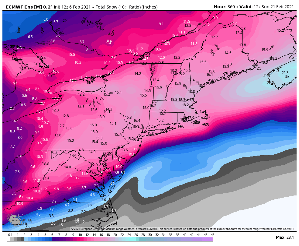
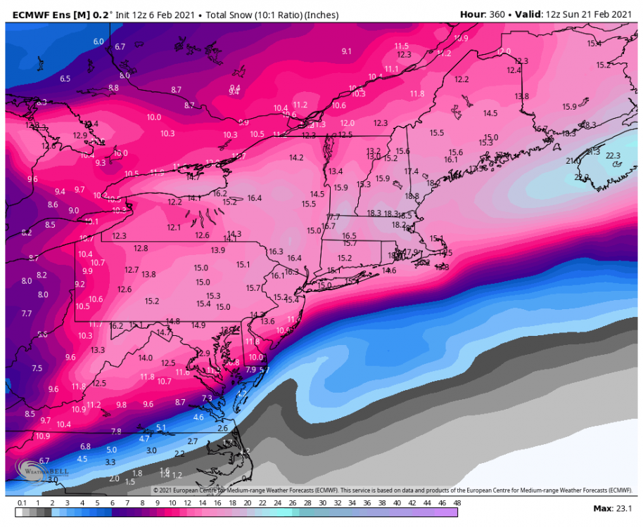
Only posted to show potential . This is hours under 214 Here the GFS sees the colder air mass and reacts, and of course, a favorable storm track as well. -
Feb Long Range Discussion (Day 3 and beyond) - MERGED
frd replied to WinterWxLuvr's topic in Mid Atlantic
I am beginning to feel a bit overwhelmed at all the storms and tracking coming up. -
Feb Long Range Discussion (Day 3 and beyond) - MERGED
frd replied to WinterWxLuvr's topic in Mid Atlantic
@WinterWxLuvr I believe this is a new threat . Beyond this time period, might be a miller A in the works. -
Feb Long Range Discussion (Day 3 and beyond) - MERGED
frd replied to WinterWxLuvr's topic in Mid Atlantic
I really don't think dry would be an issue, there seems to be a steady supply of disturbances. I am search for an all snow event , eventually with the deep arctic cold and snow cover to our North, and even colder air in the long range, if we don't get an all snow event, we never will. -
Feb Long Range Discussion (Day 3 and beyond) - MERGED
frd replied to WinterWxLuvr's topic in Mid Atlantic
This is the coldest version yet again. Colder by mean and colder by extent as well. Been many a years since I have witnessed this. I feel this raises the bar on colder storms in our area eventually. Also the NPO index continues to go towards a negative 3 SD near Feb 11 th. Looking for artic cold to maximize in our area after the 15 th. Also when seeing the progression of the GFS eddy heat flux it appears there could be increased odds of a mid Atlantic Snowstorm in the 15 th to the 18 th. -
Unless the heavier banding gets here this will be below the forecast of 3 to 6 . Currently about 1.25 inches. Happy for you !
-
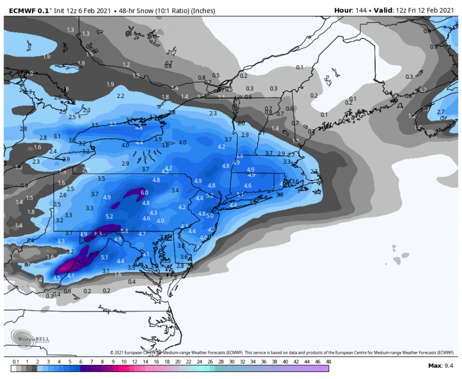
The heaver bands are flexing and waning , seems you are under one of the larger ones. Here the early AM band has moved on, hopefully watching to my SW for another. There were 4 heavier bands at first , now it seems we are going towards 2 bands, one near psu land and the the lower Eastern Shore moving towards Dover. The one nearing Baltimore has weakened.
-
Feb Long Range Discussion (Day 3 and beyond) - MERGED
frd replied to WinterWxLuvr's topic in Mid Atlantic
This is just crazy. First the almost - 6 SD dive in a few days, and even more intriguing is the recent reversal - from the AO going positive in a couple weeks, instead possibly going back down the third week of February. Continued blocking and colder scenarios in a back drop of expanding snow North America cover..thumb.gif.68434755bf1ae2d1974fb0af735f8262.gif)
-
Feb Long Range Discussion (Day 3 and beyond) - MERGED
frd replied to WinterWxLuvr's topic in Mid Atlantic
Wow, get some snow cover next week and may be able to keep a while, it if things time up correctly. Wonder the expanding cryosphere effect on future model runs . -
Feb Long Range Discussion (Day 3 and beyond) - MERGED
frd replied to WinterWxLuvr's topic in Mid Atlantic
Thanks for pointing that out, but EPS did look better. Hoping the colder snowier version wins out, it will be tough, but in the realm of possibilities. -
Wow, had no idea it was that high out there in psu land. Snowing pretty good here in Middletown, much better rates than the last storm. Very pretty out there.
-
Feb Long Range Discussion (Day 3 and beyond) - MERGED
frd replied to WinterWxLuvr's topic in Mid Atlantic
As you are aware, trends might be suggesting colder and more snow, versus ice. Here is another way to look at it in this animation. Focus on our area, not so much Virginia and NC in the time loop. Also, many disturbances in the flow as well. -
Feb Long Range Discussion (Day 3 and beyond) - MERGED
frd replied to WinterWxLuvr's topic in Mid Atlantic
What a progression. Tasty! -
Feb Long Range Discussion (Day 3 and beyond) - MERGED
frd replied to WinterWxLuvr's topic in Mid Atlantic
-
Feb Long Range Discussion (Day 3 and beyond) - MERGED
frd replied to WinterWxLuvr's topic in Mid Atlantic
Some of this falls here.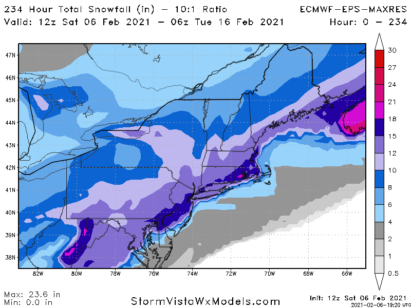
-
Feb Long Range Discussion (Day 3 and beyond) - MERGED
frd replied to WinterWxLuvr's topic in Mid Atlantic
I would truly think, and hope, that based on the pattern at some point during the next 15 days we will have an all snow event with high ratio snowfall. -
Feb Long Range Discussion (Day 3 and beyond) - MERGED
frd replied to WinterWxLuvr's topic in Mid Atlantic
@psuhoffman what do you make of euro taking pv Wesr ? I -
Feb Long Range Discussion (Day 3 and beyond) - MERGED
frd replied to WinterWxLuvr's topic in Mid Atlantic
-
Feb Long Range Discussion (Day 3 and beyond) - MERGED
frd replied to WinterWxLuvr's topic in Mid Atlantic
Nice discussion by Mount Holly on the threat for the period Feb 11 th to the 13 th. Another brief round of high pressure is expected Tuesday night and Wednesday, but the next southern-stream system migrates rapidly eastward across the central U.S. during this time frame. With subtly increased downstream ridge amplification, the Gulf of Mexico should be open for business for this next system. With improving dynamics via a strengthening anticyclonic upper- level jet in the Northeast, widespread lift should generate a broad region of precipitation across the lower Mississippi Valley northeastward to the Ohio Valley and central Appalachians by Wednesday night. Low pressure will strengthen in vicinity of the somewhat zonally-oriented baroclinic zone across the Ohio Valley eastward to the central Mid-Atlantic on Thursday. The GFS and ECMWF have begun to converge on a solution in which translation of low pressure occurs to the Mid-Atlantic coast by Friday. This event has many characteristics of a significant winter storm for the Northeast with all of the complications we know and love to hate in Mid-Atlantic winter-weather forecasting. There will be antecedent high pressure to the north (albeit in a somewhat transient sense) and slow-to-erode cold air in our region, a strong fetch of moisture from lower latitudes in advance of the developing cyclone, and phasing of the northern stream and southern stream that initiates well west of the coast. Of course, there will also be significant variations in the evolving low near the coast, substantial warm/moist advection introducing precipitation type concerns on the south side of the system, and timing issues both with the initial onset of precipitation (typically too fast) and with the potential dry slot (with systematic model biases sure to play a role here). A lot to digest, certainly, but the bottom line is that another impactful winter storm may occur in at least portions of our area by week`s end. Stay tuned. -
@CAPE We talked before about the warming Atlantic. Very interesting, may explain why some warmer ocean fish are now closer to shore, and also the effect of the NW Atlantic anomaly on weather patterns, storm tracks and hurricanes.
-
Is this a new tool ? I recently saw it posted for the first time under the NBM reference. Thanks for the breakdown.


.gif.02fd05b0e51a7f53fc90ba92d5e9b874.gif)