

frd
-
Posts
7,151 -
Joined
-
Last visited
Content Type
Profiles
Blogs
Forums
American Weather
Media Demo
Store
Gallery
Everything posted by frd
-
My kind of ice "whimper".
-
Feb Long Range Discussion (Day 3 and beyond) - MERGED
frd replied to WinterWxLuvr's topic in Mid Atlantic
A little old but still a nice illustration -
Feb Long Range Discussion (Day 3 and beyond) - MERGED
frd replied to WinterWxLuvr's topic in Mid Atlantic
Progressive could mean colder and that makes the ICON evolution a possibility. Models will continue to have problems in the short range. -
Well, this event here was the biggest of the season ( ha ha ) with 4 inches before compaction. Looks pretty on the trees. Yippee !
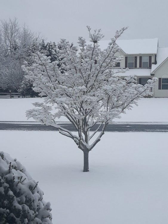
-
Feb Long Range Discussion (Day 3 and beyond) - MERGED
frd replied to WinterWxLuvr's topic in Mid Atlantic
Frisbee -
Feb Long Range Discussion (Day 3 and beyond) - MERGED
frd replied to WinterWxLuvr's topic in Mid Atlantic
Take some kind of Miracle to get snow and cold. I've given up on this winter , looks like the cold air next week erodes and all the blocking has delivered practically nothing. -
Feb Long Range Discussion (Day 3 and beyond) - MERGED
frd replied to WinterWxLuvr's topic in Mid Atlantic
I want my snow squalls -
Feb Long Range Discussion (Day 3 and beyond) - MERGED
frd replied to WinterWxLuvr's topic in Mid Atlantic
Recall there was actually quite a bit of decent consensus from the ensembles that decent cold was coming but now it really doesn't look that great, most of the cold is out West -
Feb Long Range Discussion (Day 3 and beyond) - MERGED
frd replied to WinterWxLuvr's topic in Mid Atlantic
Honestly thinking that this is the last chance at getting lucky for while in terms of significant area wide snowfall in areas that have missed most of the pathetic snow this season so far. . Hopefully changes with the TPV take place in the days ahead and the Euro OP track may trend more Southward in time . EPS is starting to hint at that. Certainly according to some, including HM the crazy situation out West may cause last minute model swings downstream and effect storm evolution even at short range. I mean really, - 6 AO and all that arctic cold. I am not interested in ice or snow to rain. I want an all snow event. -
Feb Long Range Discussion (Day 3 and beyond) - MERGED
frd replied to WinterWxLuvr's topic in Mid Atlantic
Very interesting, the TPV fujiwara effect. So what does this mean? Well, expect the unexpected. When it moves East eventually, will it shear out ? What will be the effect on confluence be ? More questions than answers. -
Feb Long Range Discussion (Day 3 and beyond) - MERGED
frd replied to WinterWxLuvr's topic in Mid Atlantic
This wasn't the look I thought we were going to.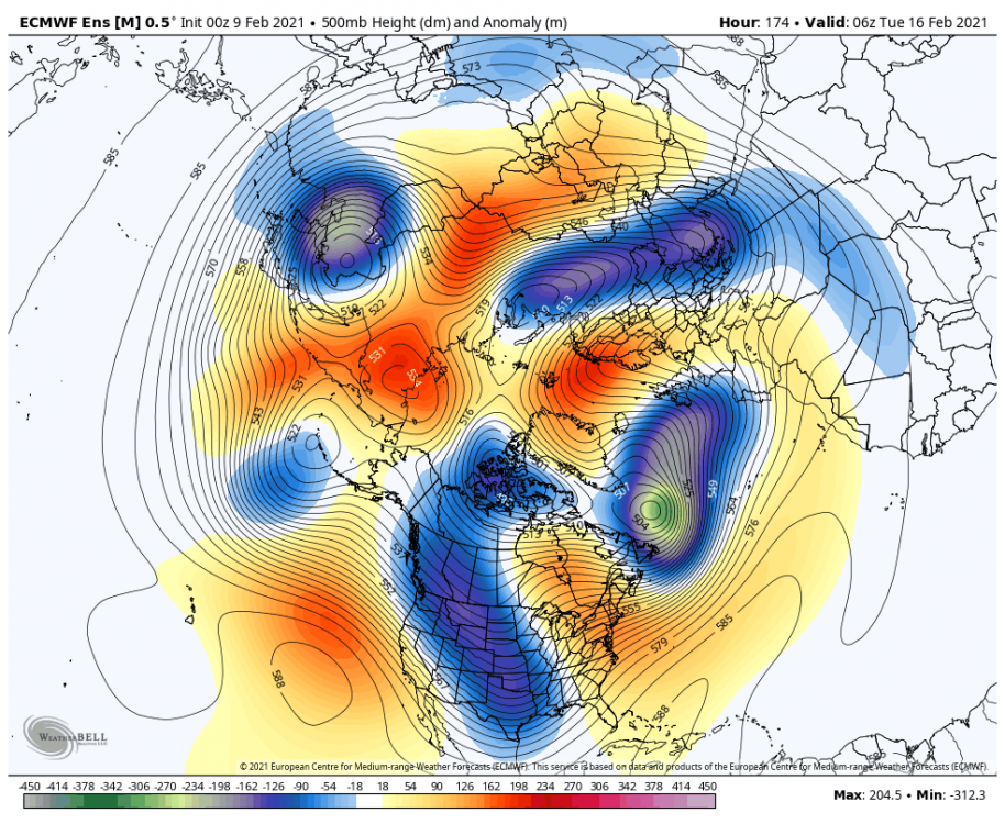
-
Feb Long Range Discussion (Day 3 and beyond) - MERGED
frd replied to WinterWxLuvr's topic in Mid Atlantic
REALLY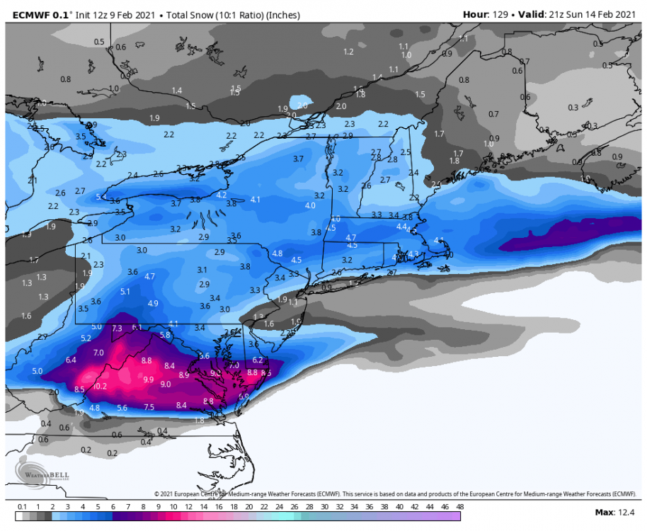
-
Northern Delaware included I hope. HM seems annoyed by models today and folks complaining. I am watching that TPV out West. Strange changes today overall.
-
At hour 30 looks better in the Midwest.
-
Feb Long Range Discussion (Day 3 and beyond) - MERGED
frd replied to WinterWxLuvr's topic in Mid Atlantic
Interesting, even though the talk focuses on areas South of us. -
Feb Long Range Discussion (Day 3 and beyond) - MERGED
frd replied to WinterWxLuvr's topic in Mid Atlantic
Wow, to that move up !.thumb.gif.38e1ea0fff6e40675ccfffb31738cebb.gif)
-
Feb Long Range Discussion (Day 3 and beyond) - MERGED
frd replied to WinterWxLuvr's topic in Mid Atlantic
I know I will be keeping a close look at the movement of the TPV , as HM mentioned this yesterday. The brunt of the arctic cold is out West but changes will most likely occur. Again, I am not searching for record breaking cold here, which may simply bring dry, but a cold running event that punches a little gusto and provides better coverage. . -
Feb Long Range Discussion (Day 3 and beyond) - MERGED
frd replied to WinterWxLuvr's topic in Mid Atlantic
GEFS agrees. Worse of winter out West. -
Feb Long Range Discussion (Day 3 and beyond) - MERGED
frd replied to WinterWxLuvr's topic in Mid Atlantic
Yeah, blocking looks to continue, but so far in terms of snowfall, it has done very poorly in delivering the goods to certain areas. -
Very difficult to get snow North of Dover this year . Two winter storm warnings and about 4 inches combined. Either WAA dies before it reaches us, or storm development is off to the North or we are not in an area for the best dynamics. Your area has done better. Really thought the baroclinic boundary would deliver. Will it ever, I am not sure. Even next week looks questionable. The 240 hour look does not favor the same areas that have been screwed over and over.
-
This is rather pathetic . This is looking like a non event here
-
Feb Long Range Discussion (Day 3 and beyond) - MERGED
frd replied to WinterWxLuvr's topic in Mid Atlantic
Yes it is a good thing, a few days ago , maybe longer it was thought the TPV would take up shop in the West, but not any longer. As Anthony mentions it will move about and swing East. This increases the odds for us to achieve colder weather. With the boundary and arctic cold nearby it increases the probabilities for snow as well. -
Feb Long Range Discussion (Day 3 and beyond) - MERGED
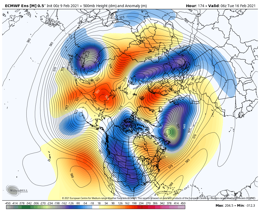
frd replied to WinterWxLuvr's topic in Mid Atlantic
-
Feb Long Range Discussion (Day 3 and beyond) - MERGED
frd replied to WinterWxLuvr's topic in Mid Atlantic
Incredible, further consolidation on a move towards - 6 SD..thumb.gif.af5a543c0b3393632e585993dcdb89d4.gif)
-
Feb Long Range Discussion (Day 3 and beyond) - MERGED
frd replied to WinterWxLuvr's topic in Mid Atlantic
Nice trends overnight into this morning. Colder scenario gaining more traction. I like this too Also notice snow cover over the mid center of country expanding South, and fringes around the great Lakes starting to freeze over . Arctic press evolving towards mid month extremes. This is yet again the coldest 10 day mean look yet. Are you kidding me a - 9.4 mean Sources regions getting colder and colder and areas Northeast of the Great Lakes getting colder as well..thumb.gif.edc23540896c4a6af5d40331a1b3f1cf.gif)


.gif.f6b71cecc1e7ef53bfd641470f3a0f47.gif)


.gif.9fd863939f0fe07520b971e65e9881f4.gif)
.gif.82d1743a449be4784b723e0d86a3b29a.gif)