

frd
-
Posts
7,150 -
Joined
-
Last visited
Content Type
Profiles
Blogs
Forums
American Weather
Media Demo
Store
Gallery
Everything posted by frd
-
Feb Long Range Discussion (Day 3 and beyond) - MERGED
frd replied to WinterWxLuvr's topic in Mid Atlantic
-
Feb Long Range Discussion (Day 3 and beyond) - MERGED
frd replied to WinterWxLuvr's topic in Mid Atlantic
Some of this falls here.
-
Feb Long Range Discussion (Day 3 and beyond) - MERGED
frd replied to WinterWxLuvr's topic in Mid Atlantic
I would truly think, and hope, that based on the pattern at some point during the next 15 days we will have an all snow event with high ratio snowfall. -
Feb Long Range Discussion (Day 3 and beyond) - MERGED
frd replied to WinterWxLuvr's topic in Mid Atlantic
@psuhoffman what do you make of euro taking pv Wesr ? I -
Feb Long Range Discussion (Day 3 and beyond) - MERGED
frd replied to WinterWxLuvr's topic in Mid Atlantic
-
Feb Long Range Discussion (Day 3 and beyond) - MERGED
frd replied to WinterWxLuvr's topic in Mid Atlantic
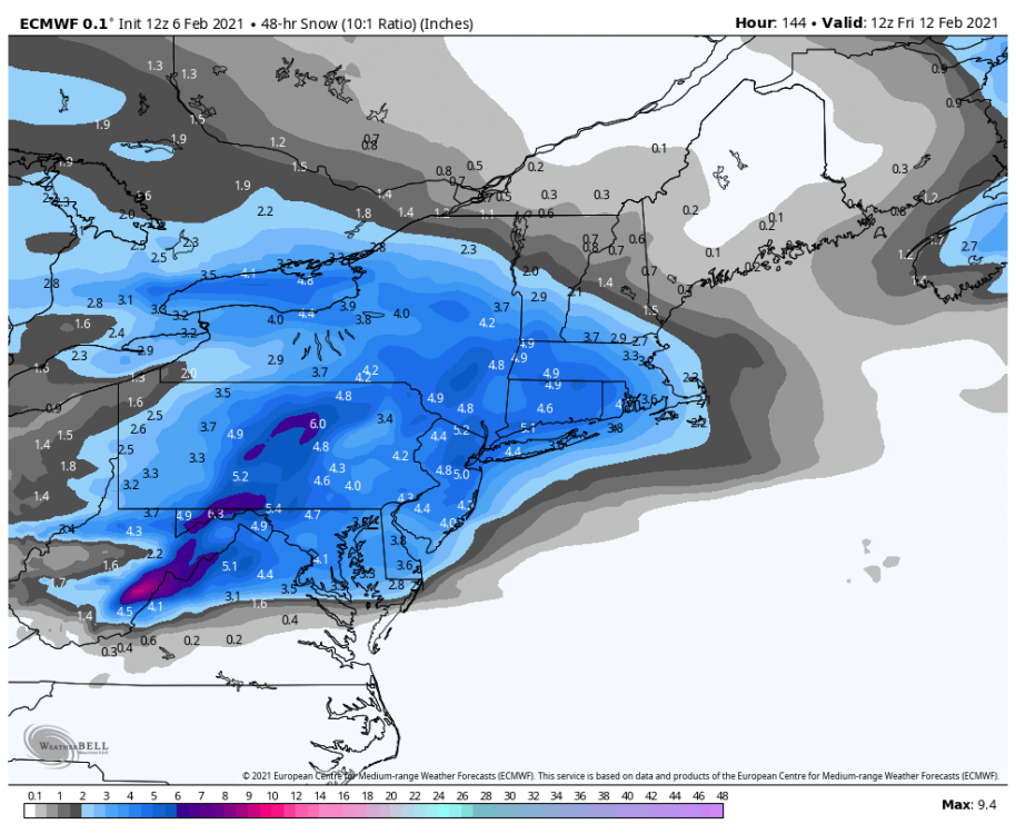
Nice discussion by Mount Holly on the threat for the period Feb 11 th to the 13 th. Another brief round of high pressure is expected Tuesday night and Wednesday, but the next southern-stream system migrates rapidly eastward across the central U.S. during this time frame. With subtly increased downstream ridge amplification, the Gulf of Mexico should be open for business for this next system. With improving dynamics via a strengthening anticyclonic upper- level jet in the Northeast, widespread lift should generate a broad region of precipitation across the lower Mississippi Valley northeastward to the Ohio Valley and central Appalachians by Wednesday night. Low pressure will strengthen in vicinity of the somewhat zonally-oriented baroclinic zone across the Ohio Valley eastward to the central Mid-Atlantic on Thursday. The GFS and ECMWF have begun to converge on a solution in which translation of low pressure occurs to the Mid-Atlantic coast by Friday. This event has many characteristics of a significant winter storm for the Northeast with all of the complications we know and love to hate in Mid-Atlantic winter-weather forecasting. There will be antecedent high pressure to the north (albeit in a somewhat transient sense) and slow-to-erode cold air in our region, a strong fetch of moisture from lower latitudes in advance of the developing cyclone, and phasing of the northern stream and southern stream that initiates well west of the coast. Of course, there will also be significant variations in the evolving low near the coast, substantial warm/moist advection introducing precipitation type concerns on the south side of the system, and timing issues both with the initial onset of precipitation (typically too fast) and with the potential dry slot (with systematic model biases sure to play a role here). A lot to digest, certainly, but the bottom line is that another impactful winter storm may occur in at least portions of our area by week`s end. Stay tuned. -
@CAPE We talked before about the warming Atlantic. Very interesting, may explain why some warmer ocean fish are now closer to shore, and also the effect of the NW Atlantic anomaly on weather patterns, storm tracks and hurricanes.
-
Is this a new tool ? I recently saw it posted for the first time under the NBM reference. Thanks for the breakdown.
-
@CAPE Best image of my hood and the extreme upper Eastern shore ( maybe you are in the lower left corner of the image ? ) I am close to the Central DE banding.
-
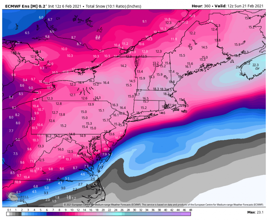
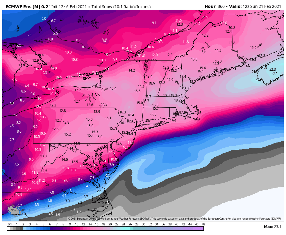
Subsidence Cool to look at, but almost impossible to forecast. Its doing a good job, but lets hope we both get under banding. Meanwhile, I am still trying to figure out the 360 hour Euro snowfall mean. Deciding whether to stock pile food stores.
-
-
From Jack Interesting observation but states the storm may yet trend NW due to possible model mishandling.
-
Wow ! A lower SD forecasted today, then yesterday.
.thumb.gif.54f76f14acc63b14d2ffbb6717070ef0.gif)
-
Same here, beautiful. Was totally sunny at sunrise, now there is this arc of cirrus with feathery wisps above, a work of art from mother nature. You can tell something is coming.
-
Feb Long Range Discussion (Day 3 and beyond) - MERGED
frd replied to WinterWxLuvr's topic in Mid Atlantic
How many days to resolve the reconsolidation? Any idea ? -
@MillvilleWx perfect call !
-
-
You had mentioned the Eastern Shore, can you share your thoughts for Northern Delaware based on the latest data ? Thanks
-
Comparison, more amped.
-
More amped solutions more likely per Jack, but short of a full phase, which would not be good for points East.
-
Feb Long Range Discussion (Day 3 and beyond) - MERGED
frd replied to WinterWxLuvr's topic in Mid Atlantic
True, lets see how things evolve in the coming days. -
Feb Long Range Discussion (Day 3 and beyond) - MERGED
frd replied to WinterWxLuvr's topic in Mid Atlantic
ENDLESS Opportunities with the target zone being the Mid Atlantic IMO , don't focus on the exact placements, or that this is the GFS, simply look at the feed of cold and disturbances. Impossible to say which ones might blossom into a bigger event at this time, but there will be opportunities, and some of those may be cold powder as well, with snow on snow. -
Feb Long Range Discussion (Day 3 and beyond) - MERGED
frd replied to WinterWxLuvr's topic in Mid Atlantic
Interested to see what this produces across our region, and the South as well. Baroclinic zone should hopefully spawn some interesting disturbances at lower latitudes. Also, liking the idea as well for squalls as mentioned by @MillvilleWx as the pattern progresses and during transition phases. -
Feb Long Range Discussion (Day 3 and beyond) - MERGED
frd replied to WinterWxLuvr's topic in Mid Atlantic
Even colder across SE Canada then previous runs today. Pretty much all of Southern Canada is well below normal. Very impressive. -
Feb Long Range Discussion (Day 3 and beyond) - MERGED
frd replied to WinterWxLuvr's topic in Mid Atlantic
GFS, what are you smoking ?


.gif.8d068e4bafe5251782b13f16503c900a.gif)