

frd
-
Posts
7,151 -
Joined
-
Last visited
Content Type
Profiles
Blogs
Forums
American Weather
Media Demo
Store
Gallery
Everything posted by frd
-
Very true. By Sunday warming begins again. What was forecasted as a nice 4 day period has turned into really just one, Saturday. Might change of course but strong upstream blocking is messing up everything in terms of a quick frontal passage.
-
Some indications the AO may start to go negative later this month.
-
Not sure the Euro has the handle on this just yet. The trend seems to be a slower frontal passage due to upstream blocking with higher rainfall totals as a result. Coolest post frontal anomalies may never make it to the coastal areas due to resistance from the WAR. FYI, the WPC seems to be going wetter over a larger area versus what the Euro has here.
-
Euro agrees, wow !
-
Certainly doesn't look like we enter October like a dessert. Soil moisture overall would favor a normal temp profile for the first part of the month. However, that would be unusual given the past 5 years. Also taking note that the AO is going towards more neutral, the NAO expected to turn negative, and the PNA after going on a major dive into negative territorry it may flip dramatically back to positive in early October.
-
Get ready for the inland trackers, coastal huggers and of course our friend the "cutter".
-
The scale's color scheme seems more dramatic than the actual numbers, but is still warmer nonetheless.
-
Still steamy out despite the wind change. Current dew point here is 70.
-
Does this include Delaware South of I-95 as well ? Mount Holly alluded to this potential in the recent 10:11 AM short-term AFDupdate, but didn't mention what the 12z CAMs showed.
-
After October 7 th
-
Dew point currently 71 at 8:00 AM., just nasty for mid September.
-
Exactly, looks aweful ! September should be another August. Climo is getting warmer and warmer right before our eyes.
-
Fits the pattern of the Euro weeklies which shows a robust WAR into early October. You just need the correct timing, but that is an odds thing. Overall, the potential is there.
-
I can dream though. I imagine surf temps will be like the last few years, maintining above 70 F. deep into September, maybe even early October.
-
Mount Holly just added Northern Delaware to a FFW Flood Watch National Weather Service Mount Holly NJ 604 PM EDT Wed Sep 8 2021 DEZ001-090800- /O.EXB.KPHI.FF.A.0010.000000T0000Z-210909T0800Z/ /00000.0.ER.000000T0000Z.000000T0000Z.000000T0000Z.OO/ New Castle- Including the cities of Wilmington 604 PM EDT Wed Sep 8 2021 ...FLASH FLOOD WATCH IN EFFECT UNTIL 4 AM EDT THURSDAY... The National Weather Service in Mount Holly has expanded the * Flash Flood Watch to include a portion of northern Delaware... including the following area...New Castle. * Until 4 AM EDT Thursday. * Thunderstorms with heavy rain are forecast to move through the region this evening into the overnight period. Heavy rainfall of one to two inches may quickly lead to flooding of flood prone and other low-lying areas due to rapid runoff.
-
As we lose a litte more sunlight everyday, along with mid September climo, it would suggest a downward trend regarding temps the next couple of weeks, however, the new normal September has us climbing higher and higher. Yuck ! From Mount Holly, this says it all....... < Strong southwest flow at 850mb will bring in much warmer air and daytime temps should have no problem rising into the mid to upper 80s through the midweek period.
-
Thanks. FYI a rogue storm hit Middletown 30 minutes ago.
-
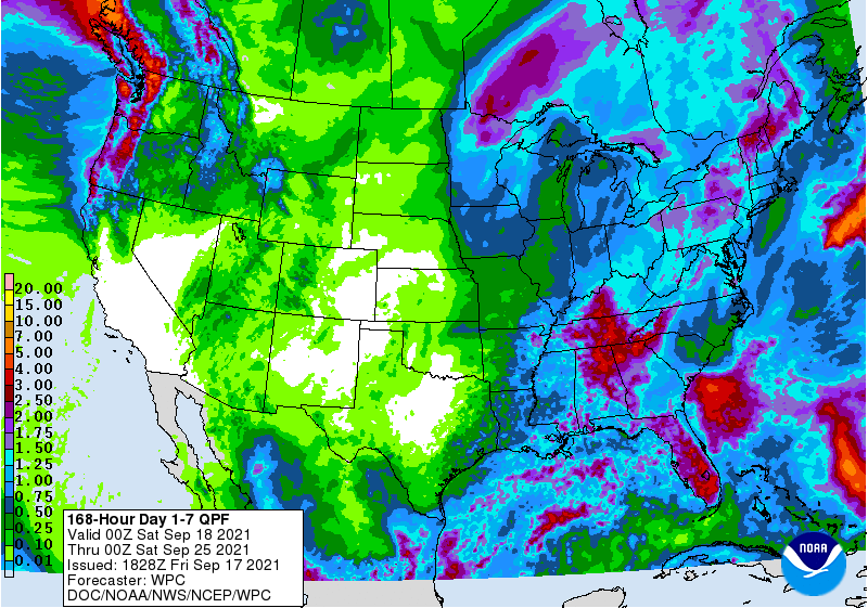
That presentation by the 12Z 3K NAM looks strange for the Eastern areas, not to mention total rainfall is pathetic. Example, most of Delware gets nothing. except for an East to West stripe near Dover, DE. Areas in the FFW . although they will flood with much less rainfall, are still only in the area of .25 inches or under. General coverage is very eratic.
-
Odds of wetter increased by Mount Holly. Area Forecast Discussion National Weather Service Mount Holly NJ 105 PM EDT Sun Sep 5 2021 The next perturbation moves into the region tonight and appears to be positioned slightly south of the first one. Guidance has trended wetter with this vort max, as it appears to be interacting a little more favorably with the larger-scale trough moving into the Lakes Erie/Ontario region by 12z Monday versus what models have been depicting in previous runs. The GFS/CMC and most of the higher- resolution guidance are signaling for precipitation to break out in a band near/south of the I-76 corridor this evening into the overnight hours, with the CMC and some of the hi-res guidance indicating a quarter to half inch of rainfall possible in this axis. This is noticeably higher than recent guidance, and even the 00z ECMWF has become a little more bullish (though hardly "aggressive"). Given this distinct trend, did bump PoPs southeast of the I-95 corridor during the tonight period, but kept them fairly modest for now pending later guidance.
-
And, create an almost perfect surfing scenario for various East Coast beaches after the well timed cold frontal passage. West winds and awesome incoming swells. https://magicseaweed.com/Wildwood-Surf-Report/392/
-
Yep ! TORNADO WATCH OUTLINE UPDATE FOR WT 483 NWS STORM PREDICTION CENTER NORMAN OK 1240 PM EDT WED SEP 1 2021 TORNADO WATCH 483 IS IN EFFECT UNTIL 1000 PM EDT FOR THE FOLLOWING LOCATIONS DEC001-003-005-020200- /O.NEW.KWNS.TO.A.0483.210901T1640Z-210902T0200Z/ DE . DELAWARE COUNTIES INCLUDED ARE KENT NEW CASTLE SUSSEX $$
-
Watch that cluster of heavy storms North of Richmand as it moves NNE. Tornado watch is up a few miles to my West in Maryland. Hope to get active later this afternoon. Maybe the tornado watch will be expanded to cover the three counties in Delaware later.
-
Not a drop of rain here. Northern Delaware getting good storms. Heard thunderstorms last 4 hours as they moved just North of my area.
-
Robust WAR makes that depiction logical. Never thought heaviest rains would go South of us. Same issue as in winter with inland runners and Great Lake tracks. I am happy with one to two inches.


