

frd
-
Posts
7,151 -
Joined
-
Last visited
Content Type
Profiles
Blogs
Forums
American Weather
Media Demo
Store
Gallery
Everything posted by frd
-
Pathetic as usual....... Went from likely to chance of storms. Reminds me of last winter in a way, when three winter storm warnings here dropped a total of 4 inches of snow. National Weather Service Mount Holly NJ 327 PM EDT Tue Sep 28 2021 Latest Mount Holly Update --- NEAR TERM /THROUGH WEDNESDAY/... There`s still a thunderstorm threat into the evening behind this morning`s convection, but most of the CAMs are backing off. Still expecting a gradual moistening and surface heating in cloud breaks ahead of the surface front and MLCAPE in the 1000-1500 range, but areal coverage is waning. PoPs have been adjusted downward.
-
Warmish
-
Question is, whether the weakening really happens and what occurs after it. Is the pv going to snap back into a tight ball, or does it remain on the weaker side going into December.
-
Exactly, remember last winter, everyone gung-ho about blocking that finally was in real-time. And also rather robust. Guess what, Canadian 10 temp means where very warm, and depite the NW flow we had very little meaningful cold to trigger baroclinic feedback/storms and also no deep cold that would be hard to scour out. We need arctic cold in my opinion combined with blocking. Some fear this combo leading to cold and dry. I actually like to play that card because we may score here in the low lands.
-
Something has broken the horrible 4 year streak, may portend to be a positive moving deeper into the fall for the lower lattitudes. Still a Nina, but might be atypical in outcomes.
-
Growing concensus for early winter enthusiasts. Of interest, is the forecated opposite state of the MJO versus last year during October, as well as Iceland/UK blocking taking place and a weakened state of the pv.
-
Updated forecast brings temperatures into the 40s for overnight lows later in the week.
-
Maybe some small hail with stronger storms on Tuesday. SHORT TERM /MONDAY NIGHT THROUGH TUESDAY NIGHT/... A progressive short wave trough will move over the Great Lakes Monday night with an attendant surface low and cold front moving towards our region out of southern Canada. While moisture is still limited, there is still weak instability forecast along and ahead of the front, so will keep scattered showers and thunderstorms in the forecast on Tuesday. Steep lapse rates and the slightly drier mid- level profile could lead to some small hail with the stronger of these thunderstorms.
-
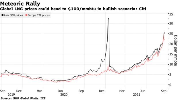
LNG prices are really going up. If winter is cold then expect huge demand and little additional supply to curb run away prices. https://bamwx.com/2021/09/24/weather-to-play-big-role-in-surging-natural-gas-prices-this-winter/ https://www.bloomberg.com/news/articles/2021-09-23/citi-isn-t-ruling-out-natural-gas-at-100-in-a-frigid-winter
-
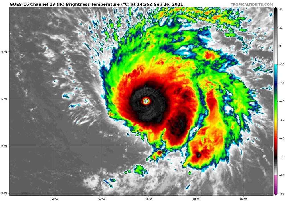
Will be of interest to keep track to see any upstream effect from the recurving typhoon.
-
I believe that is a record block. As some have stated, we need record blocks these days to get any meaningful cooling. from bluewave
-
Nice to see that the highest skill for December is going for the weakest 100 mb vortex. Of course, in our climo even with a weakened vortex and blocking in the AO and even the NAO regions does not insure winter weather in these parts in early to mid December. But, I imagine that might be a plus for December holiday spirits and such, regardless. As many know here, we really need a true source of arctic air to tap to achieve snowfall in December away from psu-land. Keep an eye on the temps in SE Canada during late November for a clue to snow prospects here in early to mid December.
-
Pretty cool animation from Stu
-
Incredible !!!!!
-
Things warming faster and faster.
-
In the end this means nothing. Just mentioning it. We are in a new background state as well. Hard to get excited about any meaningful winter weather since the super El Nino reset. Even blocking doesn't work anymore. Less cold air to work with and less baroclinic boundaries .
-
October following September as a new later summer month. Well, that might be grasping, but obvious the cooling that was modeled is vanishing The cooler weather beyond day 5 might simply be falling daily temps following climo.
-
from bluewave. And yes, the dew points have been off the hook ! < Continuation of our new subtropical climate theme. The dew point at JFK reached 70° again today. This was the 64th day so far this year. All the top years for 70° or higher dew points have occurred since 2016. https://mesonet.agron.iastate.edu/plotting/auto/?_wait=no&q=161&network=NY_ASOS&zstation=JFK&var=max_dwpf&dir=aoa&thres=70&month=all&year=2021&dpi=100&_fmt=js #1…..89 days….2018 #2….77 days…..2019 #3….68 days…..2016 #4….64 days…..2021…2020 >
-
The first significant drop in the AO might be in the cards for late month. Would like to see this actually happen to the degree forecasted and verifify to lend credence of computer modeling of a weak PV in November and December .
.thumb.gif.5c73217a831263ec31313978eb916389.gif)
-
Are you sure about that? This stat, ( below ) is for nearby NY Central Park, but other sites up and down the east coast have been warming dramatically. This is from Donald Sutherland recent post: New York City's Central Park is on track to record a low temperature of 70° or above today. The mean last date such a temperature has increased 4 days from September 10 (1951-80) to September 14 (1991-20). The interval from the first and last dates has also widened 9 days to 104 days during that time. Most of that widening has occurred during the most recent 30-year period (104 days vs. 96 days for 1981-2010). Overall, September has been warming to the extent that it is now more an extension of summer than gateway into autumn.
-
I will take this as a positive start.
-
I'm not sure what you're really talking about. Originally the front was forecast to pass our area on Wednesday. Thursday and Friday we're going to be sunny, if you read the Mount Holly AFD you'll still see that Wednesday and Thursday look unsettled. The sun will break out Friday morning late. I would appreciate if people pay attention to a poster's entire post. I said things may change , I never said it's certain. fyi nothing in weather is definite


.gif.feefdb4124b0d0eecbf21da5c8583565.gif)


.gif.d617dc01794f476bb362d84e9a4009c0.gif)