

frd
-
Posts
7,151 -
Joined
-
Last visited
Content Type
Profiles
Blogs
Forums
American Weather
Media Demo
Store
Gallery
Everything posted by frd
-
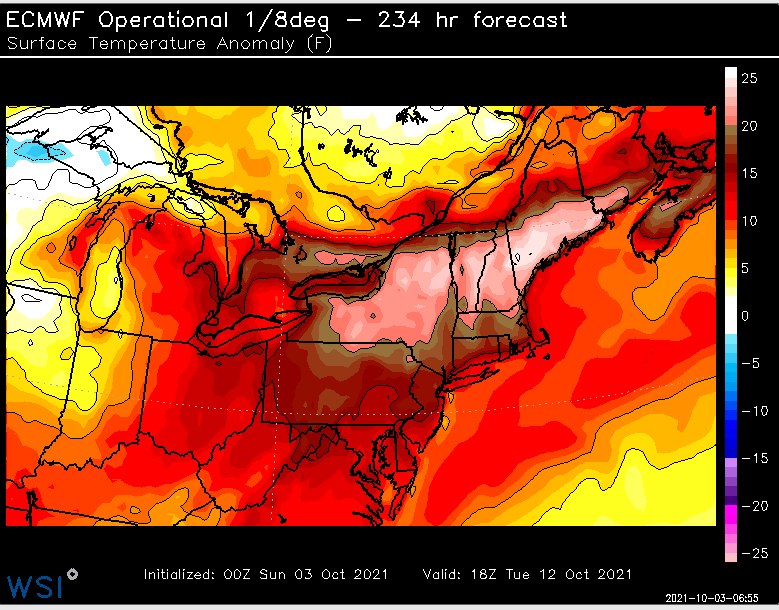
Seems the Euro still doesn't get things correct at range.
.gif.7a03c6ac04904c3af880b6dc9ab05f86.gif)
-
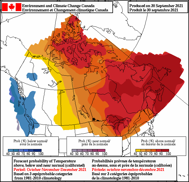
Some of the warmest Octobers on record have produced this in the following Novembers.

-
Went to the dog park, just got back. Feels like August out there Yuck !
-
The warmer this October ends the higher the odds of a colder Novemember into and early to mid December . So far things look to line up very warm in the NE
-
Yes, but some here say don't try to forecast past day 10. Because the forecast will be wrong. Hard to deny October warmth. ( and October humidity as well )
-
Another October cementing it's reputation as a rapidly warming month. No denying the trend. Some thought it would turn out cooler than normal, that's not going to happen. And yes, I am saying that knowing it's only the 3 rd of the month.
-
Possibly central Pac based La Nina setting up during the boreal winter. There is support for that outcome.
-
Pull the rubberband
-
Colder
-
QBO check
-
Well your seed may wash away. The trend is wetter !
.gif.b0704765cca4b6c71527b9436e105a03.gif)
-
At least we are not off to the races
.thumb.gif.8b110f400ce1ea414a2851f5f03597d1.gif)
-
Nothing like a 60 foot wave.
-
Wow !
-
End of next week looks depressing, unless you are reseeding your lawn. .
-
Not a good start for eventual early season cold air delivery. Hey, but whatever. This seems to be the recent par for the course deal.
-
Low of 47F.
-
From bluewave , his thoughts echo in our region as well. A return to warmer than average temperatures following a brief cooler to near normal first day of the month. This matches up with September and October being the fastest warming months of fall. The monthly temperature increases from 81-10 to 91-20 have been more pronounced during certain months. Newark and Islip are compared below. The +1.0 or warmer months for either station were bolded. So we get an extension of summer into September. ……….EWR…..ISP Dec…+1.5….+1.5 Jan….+1.2…+1.3 Feb….+0.5….+0.5 Mar….+0.4….+0.6 Apr….+0.5…..+0.6 May...+0.6….+0.9 Jun….+0.3….+0.6 Jul…..+1.4…..+1.1 Aug...+0.6….+0.9 Sep….+1.0….+1.3 Oct…..+0.9..+1.4 Nov….+0.2..+0.5
-
Was a pathetic Nino, screwy SOI and strange MJO , and it did not behave like your old fashion El Ninos.
-
For our area away from the higher elevations we really need the Pac to cooperate.
-
Its a psychological relief to know in advance that the odds of a normal winter for the Mid Atlantic outside of the higher elevations is going to be a challenge. That notion typically fits well with a Nina. Data supports less and less snowfall the last 5 years from generally DC and points South and SW. I also mentioned last winter I feel that a + PNA is more important than a super negative AO. Donald S. may even have the stats to prove this. Nothing is simple anymore, prior positive weather teleconnections need to be taken with a step back. No one really knows what this winter will hold, outside of the persistance track of late.
-
Latest IRI/CPC models going for a weak Nina. Well, except the CPC, but the other 26 models, including the Euro, keep the Nina weak.
-
Interesting.
-
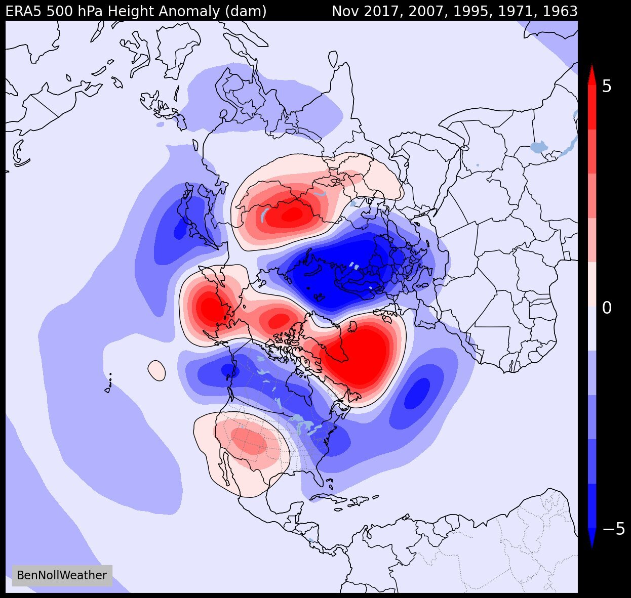
I was referring to Canada simply being colder versus torching. Hence my reference to the Canadian 10 day temperature anomoly. Folks assumed a -4 SD AO last winter would lead to colder and snow, it didn't.


.gif.c8bcdf01d72c5fd91ea101ea41f2aac9.gif)