frd
-
Posts
6,472 -
Joined
-
Last visited
Content Type
Profiles
Blogs
Forums
American Weather
Media Demo
Store
Gallery
Everything posted by frd
-
Feb Long Range Discussion (Day 3 and beyond) - MERGED
frd replied to WinterWxLuvr's topic in Mid Atlantic
Hot off the press, the 1/16/2021 GEFS lost all its members that supported a stronger vortex. Also noticed the extended duration of easterlies. Nice -
Feb Long Range Discussion (Day 3 and beyond) - MERGED
frd replied to WinterWxLuvr's topic in Mid Atlantic
Clustering supports that -
Feb Long Range Discussion (Day 3 and beyond) - MERGED
frd replied to WinterWxLuvr's topic in Mid Atlantic
Good , weaker vortex. -
Feb Long Range Discussion (Day 3 and beyond) - MERGED
frd replied to WinterWxLuvr's topic in Mid Atlantic
This goes along with the above post regarding the GFS NH polar vortex ellipse profile animation . Judah's animation matches the animation form stratobserve.com -
Feb Long Range Discussion (Day 3 and beyond) - MERGED
frd replied to WinterWxLuvr's topic in Mid Atlantic
Lastly, another huge change from what was forecasted the last 14 days . Movement towards Northern NA versus Siberia. This starts near hour 240 and speeding up from there. https://stratobserve.com/fcst_ell_vert -
Feb Long Range Discussion (Day 3 and beyond) - MERGED
frd replied to WinterWxLuvr's topic in Mid Atlantic
Another significant change in the long range , a rather broad vortex in a N S elongated fashion is predicted versus what was forecasted a few days ago as a solidified , more organized tighter vortex, mostly over Eurasia. -
Feb Long Range Discussion (Day 3 and beyond) - MERGED
frd replied to WinterWxLuvr's topic in Mid Atlantic
As psu used this image in a previous post, but wanted to point out this is an improvement from a couple days ago. Basically the - NAM states not deteriorating . -
Feb Long Range Discussion (Day 3 and beyond) - MERGED
frd replied to WinterWxLuvr's topic in Mid Atlantic
Tasty John Homenuk Recent EPS runs have trended stronger with Greenland blocking in the 5-10 day range again - now a 3 sigma event. There are also hints that a northern stream disturbance will be forced underneath it Days 7-10. If correct, would open door to a Mid Atlantic/Northeast winter storm. 3:14 PM · Jan 15, 2021· -
Feb Long Range Discussion (Day 3 and beyond) - MERGED
frd replied to WinterWxLuvr's topic in Mid Atlantic
You are going need a larger gravy ladle. Damn and some freshly ground black pepper. -
Feb Long Range Discussion (Day 3 and beyond) - MERGED
frd replied to WinterWxLuvr's topic in Mid Atlantic
Great point ! -
Feb Long Range Discussion (Day 3 and beyond) - MERGED
frd replied to WinterWxLuvr's topic in Mid Atlantic
Yikes !! -
Feb Long Range Discussion (Day 3 and beyond) - MERGED
frd replied to WinterWxLuvr's topic in Mid Atlantic
And I stand firm that now you need a cooperative Pac to get a decent SECS in the Mid Atlantic. New England doesn't require that. You want a more severe snow storm? Then you need some NAO help to raise the bar. -
Feb Long Range Discussion (Day 3 and beyond) - MERGED
frd replied to WinterWxLuvr's topic in Mid Atlantic
I could speculate if we had the same HL configuration and Greebland block in a Nino with a more active STJ maybe things would work out better but one, I am getting ahead of myself because who knows, we might score but I also know things seem to be different now, where we are fighting a altered base state. Also, Anthony mentioned the best cold dynamics and baroclinic storm opportunities are on the other side . I have witnessed many times though that a stout NAO block and severe - AO yielded little snow but this time it's been good indices for weeks and weeks and zero snowfall. That is the first time I have seen that. -
Feb Long Range Discussion (Day 3 and beyond) - MERGED
frd replied to WinterWxLuvr's topic in Mid Atlantic
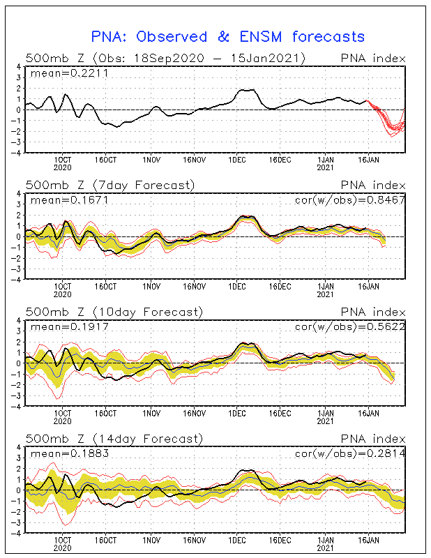
I have been reflecting and feel when we talk about threat windows, intervals of + PNA , transit ridges it really means we are in trouble. Anyone whom doubts the Pac needs to reassess in my opinion. SSWE, - NAO, - AO , - NAM state, HL blocking, etc., etc., mean nothing , all that really matters is that the Pac cooperates and that Canada doesn't torch in December. When I see some - SD deviations on the Canadian 10 mean and see the Pac improve instead or worsen only then do I feel we have a chance at something more than a pity event. Look at how this PNA has evolved.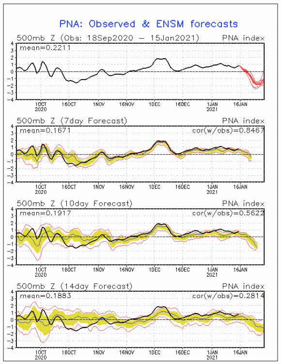
-
Feb Long Range Discussion (Day 3 and beyond) - MERGED
frd replied to WinterWxLuvr's topic in Mid Atlantic
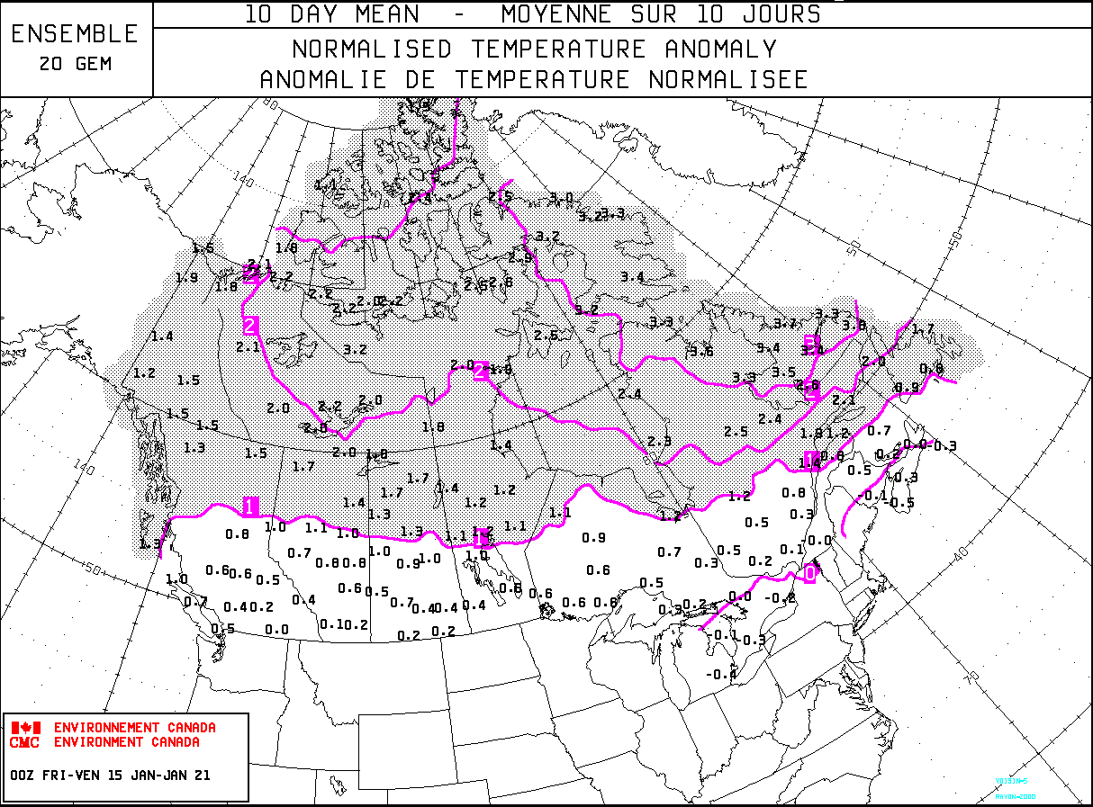
Digital snowfall low end forecast did good so far. May escape Jan with well below normal snowfall. Also above normal temps. Boring weather ahead contrary to Accu weather's news release last week for the East. HL blocking a complete failure by itself. Southern Canada finally with normal temps , wow !
-
Feb Long Range Discussion (Day 3 and beyond) - MERGED
frd replied to WinterWxLuvr's topic in Mid Atlantic
Another plus with those maps - if they are relatively close to reality storms will initially put down snow cover to our North possibly aiding with CAD and may help us eventually as the pattern progresses and the baroclinic zone shifts South. -
Feb Long Range Discussion (Day 3 and beyond) - MERGED
frd replied to WinterWxLuvr's topic in Mid Atlantic
End of the month, a couple big ones. Of course, fantasy land and beyond. -
Feb Long Range Discussion (Day 3 and beyond) - MERGED
frd replied to WinterWxLuvr's topic in Mid Atlantic
Maybe a hybrid system, I could envision an evolution towards a lower latitude grouping of lows as we near the period 26 th to the 29 th. Would be nice to see stronger Highs up in Western Canada to funnel the colder air SE -
Feb Long Range Discussion (Day 3 and beyond) - MERGED
frd replied to WinterWxLuvr's topic in Mid Atlantic
I believe this is a significant shift North on the ensembles for the 22 nd and 23 rd. -
Feb Long Range Discussion (Day 3 and beyond) - MERGED
frd replied to WinterWxLuvr's topic in Mid Atlantic
Wonder the cause? Incredible if you ask me. And, a little scary, possibly source region decay. -
AO negative since December 1 st and we may go the entire month of January without a significant snowfall .
-
Looking like both the storm on the 22 nd and the 25 th are rain makers . Heights up in the SE US. More of the same This sucks !
-
I imagine this is good to know in a long term thread. The effects of the SSWE can result in both record cold and record warmth as well as Amy mentions. Example Spain and the heat in Turkey.
-
Some indications the NAM state may be changing towards early February. Granted, the surface reflection of the SSWE are just now progressing as HM mentioned.
-
Based purely off of the retrogression in NA combined with movements up top it appears a carving out from the SSWE pushes colder air our way, and very importantly the baroclinic boundary in the process, and may even amplify and increase the tendency for East coast storm genesis. When look at the loops it appears the highest probabilities for this to occur is from Jan 24 th to Jan 29 th. A cool new tool by the way from Simon