

frd
-
Posts
7,133 -
Joined
-
Last visited
Content Type
Profiles
Blogs
Forums
American Weather
Media Demo
Store
Gallery
Everything posted by frd
-
You deserve some for sure! Sure feels like a December day ! Might need to find the winter hat, because I don't have a lot of hair on my head
-
Wind chill 29 here. Brrr ....but it feels refreshing !
-
After this cold blast we're looking like multiple weeks to take care of any outdoor yard issues
-
It was noted that the shoulder months of the winter might have the best potential due to the weaker state of the polar vortex
-
I did read from a couple of sources that at least for the time being the likelyhood of the trop and stat pv linking is low. Also some overall lack of structure. AO still progged to decline after November 6 th.
-
Hopefully the tropical connection is gone. That accounted for several huge events. The amount of rain has caused much frustration for farmers and allergy sufferers and those whom simply enjoy sunshine and outdoor activities.
-
Exactly, fast Pac flow has been setting records for past couple years in regards to super fast jet stream and breaking down + PNA attempts.
-
October 2020 General Discussions & Observations Thread
frd replied to uofmiami's topic in New York City Metro
This is certainly a repeating process the last few years, and even going further back, as you mention. Wonder if we transition back to a colder pattern after November 20th and repeat the last couple Decembers which featured colder weather, but also an abrupt change after December 20th to much warmer right in time for the holidays. Possibly the next increase in NA snow cover coincidences with increased ridging out West and a improved MJO progression. -
Wonder if we have not seen our last tropical rainfall connection. Something could down in November.
-
The core remains resilient.
-
If I recall correctly last November provided the old reliable head fake with a rather - AO. The real move up with the AO did not take place until December I believe.
-
I totally agree. I work in a health care setting and it is bad enough already with the backdrop of Covid and limitations on activities in the more at risk populations, but add on this lack of sunshine, with shorter days and the chill coming, it certainly is draining on one's mental health.
-
This is not a good sign, at least initially.
.thumb.gif.cc75f2f776c2d8a9dd7f23164daaaa28.gif)
-
Did you read what I have in the first line ? I did mention they feel the warmest winter ever is possible . < Here are my notes : They feel the polar vortex takes up camp in the Eurasia / Siberia, if that happens then expect the warmest winter ever. > Now if they are wrong and the PV weakens, or there is HL blocking , etc. They risk a rather substantial seasonal forecast bust , and then it becomes two years they have to revise. Massive amounts of evidence ( climate warming, analogs, persistence, Nina background, West Pac warm pool, + NAO persistence, etc. ) all point to warm winter in the Mid Atlantic and SE. , including large portions of the country. However, I am not sold yet on what transpires this winter. I still like late November and early December as an opportunity for cold here.
-
Yes
-
Hopefully they don't have to reverse course like last year. But, I am hoping for that.
-
BAMWx Winter outlook - I summarized the webinar this morning. One word, warm. Opposite last year, and really following Nina climo. Here are my notes : They feel the polar vortex takes up camp in the Eurasia / Siberia, if that happens then expect the warmest winter ever. They feel low sea supports a poor cryosphere and no cold air source for most of the United States. They stated a basin wide Nina supports a very warm winter. They mention the QBO missed the Easterly phase and the West phase is not conducive to a - AO. This favors a very warm winter. Last time we had a - NAO winter was 2011. Recent climate suggests it will not happen. Carbon release = arctic warming and seeing a strong PV already, from fire burn. They see no chance at a - NAO. A very warm winter again. Low chance of a SWWE. Only hope is that the PAC might induce PV stretching or elongation. They feel the MJO is active the next month or two. Best months for cold ( if there is any ) might be shoulder months of December or March due to the weaker PV as compared to very strong PV in Jan and Feb. MJO really favoring phase 5, but movement is expected , the standing wave might be changing. Have had the standing wave for over a month. Most models favor a cold Alaska and a warm US except the PAC NW. Models are really at a consensus for a warm winter, with little if any snowfall in the East. Lastly, they mention any cold air does that make it here will have very little staying power.
-
October 2020 General Discussions & Observations Thread
frd replied to uofmiami's topic in New York City Metro
Makes you wonder if we get the -NAO effect later in the season from the recent hurricane activity and elevated ace. ( even though not extreme ). In the back of my mind though is the consequence from all the fires and the model's seasonal call for a mostly + NAO, although there does seem to be at least the possibility of some cycling at times with the phase of the NAO. -
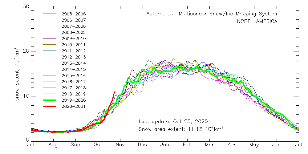
Seems the MJO's Eastward progress has slowed, at least for the time being, with the latest AO forecast consolidating on a consensus move to + 4 SD, a very significant development. However, after this, a drastic move down is forecast to begin, possibly associated with the MJO moving into more conducive phases, along with changes in the Kara Sea region. ( possibly sea ice related ) These developments may promote a change later in November within the NAM. Possibly even a elongation of the PV later in the month. Even though the latest guidance forecasts a stronger PV, at least short - term. The recent incredible advance of NA snow cover might have played a role in the record cold out West. As snow cover in North America either stalls, or even decline during the next 2 weeks look for another increase mid November going into early December. Possibly combining with a negative AO and or -EPO change to bring much colder air onto the East later November and early December.
-
October 2020 General Discussions & Observations Thread
frd replied to uofmiami's topic in New York City Metro
@bluewave it appears some things that correlated in the past do not show or result in the same outcomes in this new regime with the WPAC warmth and record IOD. Maybe even throw in Greenland ice melt as well. The QBO's sudden shifts recently is one, and this post about the October - NAO and active hurricane years is another. -
October 2020 General Discussions & Observations Thread
frd replied to uofmiami's topic in New York City Metro
Interesting -
Presently the polar vortex is strengthening but hopefully by the third week of November there are some signs that this may change - highly speculative the latest models from the GEFS shows the strengthening of the polar vortex currently. Actually some modeling posted by Simon at his strat site indicates a strong(er) pv for the next 46 days, which fits the seasonal models. Dr. Amy Butler posted a cool scatter plot which shows in a Nina you can certainly have pv disruptions. And like the NAO hard to predict with skill.
-
After 5 months of this crap I don't blame you. Once again we are both in the bullseye.
-
For the 25 th of October this is impressive.
-
True. Once in a while it finds the most likely outcome first.

.gif.7390841b329a1805bb205ad012abb526.gif)

