

frd
-
Posts
7,133 -
Joined
-
Last visited
Content Type
Profiles
Blogs
Forums
American Weather
Media Demo
Store
Gallery
Everything posted by frd
-
- EPO / perturb the PV / NEW EPS = Yeah baby !
-
Wonder the implications further down the road, if and when, the pv weakens ? I would speculate good for cold and snow if we weaken the PV as this would improve the odds of favorable NAM state. Really liked the long range zonal wind forecast from the Euro yesterday. I believe Isotherm has Jan. in mind for a better cold and snow outcome. The evolution from mid December on will indeed be very interesting. As we read the period around mid December is key to observing effects from wave 1 event and maybe a further weakening of the PV. You can't help but feel a bit better about the odds of snow and cold here eventually .
-
Wave 1 configuration coming up Anthony Masiello @antmasiello Replying to @antmasiello Guidance in the extended range is rapidly intensifying the Aleutian High in stratosphere/wave 1 configuration. 2:43 PM · Nov 30, 2020
-
Yes, based on MJO movement and other signals. You can be skeptical, however, it would seem the evolution of the pattern to warmer near the 20th is logical. This is a long-range discussion and the period near the 20 th is weirdly associated with a turn to milder in the East.
-
This is so true i....t was mentioned early in the season the importance of the cryosphere The latest 10-day mean temperature from the Canadian ensemble shows most of Canada is above normal. Granted it's cold for Canada but not cold nearly cold enough for us as you mentioned. Hopefully at some point during the winter Canada can be loaded with extreme cold which coincides with a - EPO discharge. Also hoping any future - NAO occurs as well after a Eastern Canada cold period.
-
As mentioned above, the change to warmer at Christmas and beyond is rather clear. Just like clockwork again. It is remarkable the change to warmer in the East near the winter solstice.
-
" Transient pattern " , the new 2020 weather buzz word. Not to be confused with the visual 1 inch mean snowfall maps always posted last winter. cough cough .... Paul Rodney I believe may have latched onto this pattern and the subsequent change later in the month of December to warmer. I always mention the 20th of December, as that has been golden in terms of the change to warmer the last 3 years, and maybe longer. But, maybe we do a continued progression back to a Nino-ish pattern in January. Again, we are in a new age of weather drivers, and as some here have mentioned, the West Pac / MJO and standing wave will all have a lot to say about the outcomes in Jan and Feb. Nice to at least see some influence here on the PV. Maybe a harbinger for January, or not. At least it is not 70 degrees after today for a while.
-
Lots of waves...... as HM posted, on would occur as wave lengths changed.
-
Can you kindly post the Euro ensemble AO, PNA and NAO please. I am asking because the AO really seems to go deeper to -SD than a couple days ago from the CPC site.
-
Update is in on the extended Euro. It does show a weakened strat vortex from mid December onward.
-
Ventrice mentioned this yesterday. I believe there is a proven lag time to impacts here in North America. Buy gas futures !
-
This is an impressive drop , razor sharp if you will, in the NAO. Have to see whether this holds in the days ahead.
-
Good thread. Seems Ural high and especially the +EAMT may weaken the vortex. Seems mid December is the tipping point to see if, and how, this goes down. Will it be enough, and will the vortex cooperate is the question. Tonight's Euro extended range will be very interesting, as Simon mentioned.
-
The call for a - EPO during mid December is gaining some traction on the long range models.
-
Don't get sucked in. Ha ha. Glad to see you posting. How you find the time is a mystery. I know your busy. We are dealing with some things that normally don't exist. or should I say coexist.
-
Not every day. 588 jeez
-
Damn the AO forecast looks good. Hope it happens !
-
A lot going for early December , especially towards the second week of December. Including a possible PV displacement, PV elongation, and the effect of a Siberian warming and the 7 day lag to NA, especially in the East. The displacement event if it were to occur could have implications for later in the month, in a way echoing Matt's thoughts from the post above.
-
Interesting to keep track of during mid to late December for any sensible weather implications in January.
-
Would be awesome if the actual blocking turns out more robust and longer lasting. I would love a December 09 event this way And to make it even better................. to happen near Christmas.
-
Extreme + PNA on the way it appears. Euro supports it as well. Question is the eventual evolution in early to mid December. Inland snow then a more significant event somewhere in the East.
-
Yes, that is true. Several mets and pros have mentioned a period in December when the NAO may drop. There is also a huge wave breaking event getting under way as well in the North Atlantic. This may have implications in the NAM domain as well . As mentioned here by Simon:
-
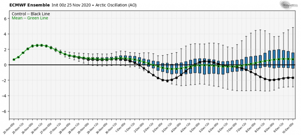
Interesting change today, with the caveat needing to see consistency in the next week, however, a nice drop forecasted in the AO domain.
.thumb.gif.4e9f9024b5da29bb098b9960a1bd762e.gif)
.thumb.gif.8746fd567649f8974f310a776bfb9133.gif)
-
Would love to eventually evolve the pattern change to a possible - EPO as HM mentioned recently moving deeper into December.


.gif.040c6b6f79c3c9905f4473c6bf03058f.gif)
.gif.1364923b8162d166997c4d8f89bad6d0.gif)