Jump to content

frd

Members
  • Posts

    5,709
  • Joined

  • Last visited

Everything posted by frd
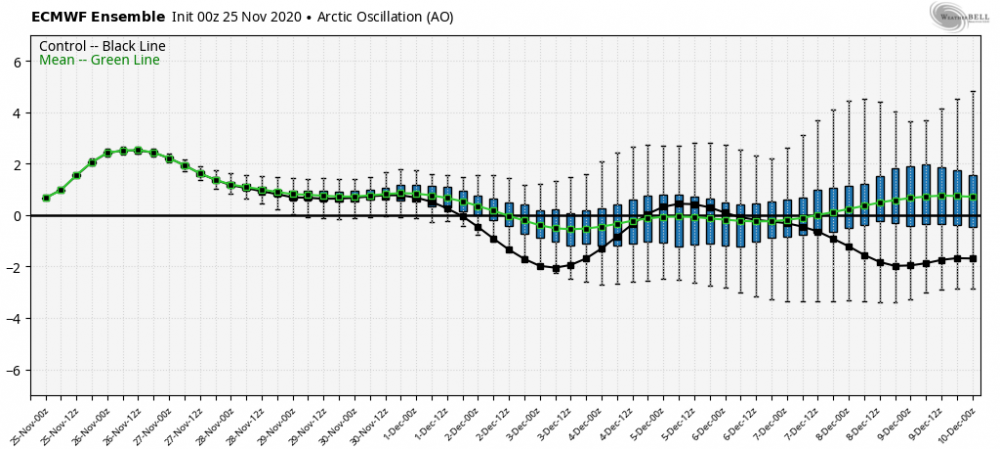
  1. Damn, looked good out West at 330 AM when I woke up. Then it went POOF ! Even .25 would have been nice but only a trace here. All of Delaware basically missed it. The dry days now start to add up. Well, less grass cutting but more watering. I hope @Eskimo Joe straw system I have down helps with the dryness. So far, so good. Hey @C.A.P.E. is this sudden dry and hot weather similiar to last year at this time or was that a bit later in July. I recall I went without rain for about 16 days and then the pattern changed and the rains and dews came from that point on. The grass fungus started after that as well.
  2. Yep, it is a bummer. I can relate. I am happy made it this long with green grass and not having to water flowers and others plants . So begins the watering chores and all the lovely things that go with it like : Bee stings, and more bee stings...more so wasps and other varieties Skeeters, ...hate them !!!!!!! Breathing dust and dirt Sweating like I am in the tropics Velvet ants ( a wasp ) cruising by my feet ( please don't bite me ) Cicada killers trying to intimidate me by dive bombing me .... My hose crimping up and the water coming to a stop followed quickly by me saying, what the F Eh, I am happy to be a live , all the above is cool with me LOL !! Getting outside is still enjoyable to me. It is like an adventure out there this time of year.
  3. I hope your right and I score later tonight. It is really dry out there. 5 days here with very little rain, if nothing tonight add another 6 days to that to total 11 days. I will keep my hopes up for the weekend to get rainfall with the frontal passage. It is almost useless to even to water the lawn. The evaporation and power of the sun now is just too much. Best to have the grass go dormant, and not water incorrectly and cause even more issues. Once we get to later August when it does rain it seems to help more and last longer in the soil , as the sun is a bit weaker then, ( shorter days to a degree and somewhat less brutal sun angle ) We enter the dog days of summer this week. Woof
  4. Cool animation, lasted a long time.
  5. I am so confident in your upbeat vibes Jebman, I will go ahead and get an off-season snow blower tune - up. It will take an hour just to remove the cobwebs, and mouse nests...... LOL, yes, it has been that long........ I am ready for the eventual next BIG winter.
  6. Not sure the eventual consequence, if any, but changes are afoot in the NE Pac, ( warming ) and the cold pool is breaking down, or so it seems in the NW Atlantic.
  7. Thanks for posting those images @C.A.P.E. I love looking at them in any season. As you age. ( me here ) I treasure experiences with storms more and more. For example my brother-in-law and I went to North Wildwood to body board yesterday. It was a blast ! Despite the wave forecast of 1 foot , LOL if you go to 10th St where there is not a sand bar , the waves are suprisingly good and the off shore West winds scooped up the waves. Had the swells been higher would have been a awesome day. Ah, lost my train of thought, sorry. As we leave my brother-in-law turns to the ocean and takes in one final look, he said, " I love days like this, it reminds of my youth, but also that you need to appreciate times like this even more once past 50. Only so many years left that my body can take this abuse, but I love it . " Thanks again CAPE !
  8. Please post those pics again here......they were great ! I think at one point back two years ago Maue had the satelite image of when the powerful storm was wrapping off the coast. Was so impressive to behold. Missed it here by not much. Some good years down the beach for snow as you mentioned.
  9. Looking at the Dover radar some very isolated cells forming and moving NE from the central Chessy Bay. Looks to headed towards the upper Eastern Shore.
  10. Yes, you are correct. The effects become less and less, and I might have read that it could even be responsible for heat further into the summer. That second part not sure though. But yeah, it is a waste.
  11. Better than hitting 100 degrees. I will still take this month. My lawn is happy as well as my garden. Without looking at the BWI stats wonder if yet again the higher overnight low temps are the cause of the warmer monthly June temps so far? That seems the case lately with an abundance of high soil moisture and last summer's super high dews. I think last summer also set a record for the average dew point being so high from July to late September. Maybe HM was the one who "might" have posted that. As for the -NAO and the interplay from the 50/50 low, seems that feature along with the record cold pool anamoly has really caused more issues further North with stalled warm fronts, and way more cloudy days for certain . Even with that said, I believe NYC is still near average, and like you said BWI +2 MTD. Even next week when looking at the warmer temps over the North and East it would seem more a function of warmer nights versus hotter days.
  12. Of interest looking way out there
  13. Today the SOI is: 20 Jun 2019 1012.56 1014.05 -19.54 AO set to drop along with the NAO Trends continue on the EPS
  14. Dehydration , you worked outside ? Hope you guys feel better. I had to get up three times last night as my dog, is going downhill.. all sort of issus developing . Went out at 3 AM to a tropical like rain forest , every window coated in dew and a slight fog, and mist as well hanging overhead. Yuck ! Then my dog has grown to fear ground bees , like the cicada killer bees even though they are mostly harmless. Takes him 5 minutes to look around and finally go. Soon those cicadas will be here , I think near July 23 rd ish
  15. Interesting it seems that when I use location in Maryland, you guys up there have been cloudier. However June on pace to go above climo cloudy this way looking at my chart.
  16. Interesting Day 1 to 3 from the WPC Zooming in on our area, seems like .50 inch, maybe .75. Not that much when you compare the wording form some of the local NWS offices. I know so far the forecast for most from the WPC from 4 days ago has not really worked out that great so far. Localized impacts are evident by the comments in this forum, and a general tough forecast for sure in nailing down everything from rainfall totals to severe weather impacts with this system.
  17. Actually better luck last week here , 48 hours of FFW has equaled about .30 here. But, the watch was a good idea, areas in Newark, DE had flash flooding and in Dover as well, very localized though. What is interesting is the morning gray theme going back to April and most of May. If you are a morning person and enjoy the first rays of sun to charge your get up and go, this weather sucks. Impact on garden not sure, but might be concerned when the tomatoes start to get to the ripening stage. Last August after the super high dews fungus set in and also grass fungus too causing the worse grass loss here in 20 years. Hey, I love your fire pit !! Nice job !
  18. Without question the ability to predict the -NAO accurately in advance is not possible. No one can I believe at this time claim to be able to. If a person states he or she can without being open and sharing how and what tool they use I just file under BS. Many pros have in the past stated using various secret formulas, solar, tripole, temps in a box over the ocean, the cold pool, cycles, ice melt, analogs etc. , etc., but to this day I have never seen a person be able to forecast the NAO more than 3 to 7 days in advance.
  19. Thanks, and yes that all makes sense. Higher temps at night, looking at the East Coast possibly. Irrigation makes sense too over the past 100 years. As you know, the article mentioned this is only summer, and the other seasons are very different. ( when comparing ) seems the oceans are at play here too , the Atlantic warming and at times the +PDO, when looking at the Fall and the winter comparisons As for the rain and crazy flow this spring speculation on the low solar min as some NASA folks have looked at it and feel there may be a relationship in jet activity and weather flow from the coming solar min. Glancing a couple days ago at your chart of the NW cold pool SSTs and looking back in time I felt there was a relationship with the cold pool and the solar min . Not scientific at all just a quick glance. The recent record was pretty obvious on that chart. And, I believe we are not at the min yet. 2020 I think ?
  20. @showmethesnow never saw this forecast using dew points. If that forecast came true I be surprised, but maybe it is related to the El Nino and blocking over Eastern Canada, because to get lower dews ( more normal vs like last summer ) here in the summer ( with the warm SW Atlantic ) I would think we need a cooler background state and a somewhat NW flow more so than average.
  21. You often read about the role of soil moisture and seasonal temps, more so in the fall and in the spring. I believe DT talks about this aspect a lot. I believe though it is many times used but may not really be a sound forecast tool. Either the area of excessive rainfall is rather small , or the anomaly is not that great and because of that it can easily be reversed by the high sun angle, longer days and high temps of late spring and early summer. Here though, in your post, it really shows this time it can not be so easily overlooked. The map is pretty impressive, not only in regards to record soil moisture, but also the vast area covered. of interest is this :
  22. This is really a remarkable record and a very interesting post by @bluewave <<<< From bluewave: No surprise that the front is stalled out near 40N with a SST gradient like this. The cold pool east of New England and the Canadian Maritimes set a new record coldest SST’s for the month of May.
  23. That is a remarkable new run for sure. I know a couple weather pros that mention the cold pool as a signal for a -NAO next winter. That would be great if it were to happen, but I am not so sure. Also, would not the theory of peaks and valleys simply create an outcome more likely of a +NAO. And, then we keep hearing about melting sea ice and warm season blocking. Maybe the current climate argues against a -NAO in the heart of winter. More research is needed. The only thing certain now is the unlikely odds of a long extreme heat wave around these parts, any time soon.
  24. @bluewave this SST configuration is also supporting the -NAO. is that true ? Seems according to Ventrice that the NAO may be trending down yet again. nothing extreme. But the general - NAO pattern is still there. Also, how does this cold pool dissapate or does it linger into the Fall ?
×
×
  • Create New...