

John1122
-
Posts
10,747 -
Joined
-
Last visited
Content Type
Profiles
Blogs
Forums
American Weather
Media Demo
Store
Gallery
Everything posted by John1122
-
December/January 2019/20 Winter Speculation Thread
John1122 replied to AMZ8990's topic in Tennessee Valley
Goodness. -
December/January 2019/20 Winter Speculation Thread
John1122 replied to AMZ8990's topic in Tennessee Valley
The GFS must have ran off EPS member 50. Buries Plateau and east. Unfortunately high and dry for the western areas for the most part. Not that its likely to play out as modeled. But lots of cold, storm signals abound and massive Pacific blocking. -
December/January 2019/20 Winter Speculation Thread
John1122 replied to AMZ8990's topic in Tennessee Valley
00z GFS is showing the negative side of massive blocking in the valley. Gulf coast areas see frozen while we are cold and dryish. -
December/January 2019/20 Winter Speculation Thread
John1122 replied to AMZ8990's topic in Tennessee Valley
It's speeding up through 4-5. Going high into 7 has a high correlation to 8-1. Lots of SE winter storms happen in 7 and 8. -
December/January 2019/20 Winter Speculation Thread
John1122 replied to AMZ8990's topic in Tennessee Valley
Break out the vodka. This is noon/1pm temps. -
December/January 2019/20 Winter Speculation Thread
John1122 replied to AMZ8990's topic in Tennessee Valley
Weeklies say goodbye to the heat after this next 7 days or so. After that it's BN to N for the rest of the run. -
My snow depth on the 23rd is 24 inches on member 50, dang compacting.
-
I could live with that! I'm going to start getting bread and milk now.
-
December/January 2019/20 Winter Speculation Thread
John1122 replied to AMZ8990's topic in Tennessee Valley
I saw that MRX actually started putting social media posts out about it already. I wonder how many places in the United States have such a unique local phenomenon. I know Mount Washington gets extremely high winds but I don't know if that has anything to do with mountain waves. -
December/January 2019/20 Winter Speculation Thread
John1122 replied to AMZ8990's topic in Tennessee Valley
Was just about to post that the EPS goes -EPO/+PNA with the coldest anomalies over our forum region. -
December/January 2019/20 Winter Speculation Thread
John1122 replied to AMZ8990's topic in Tennessee Valley
Your area looks like it's in a spot that's liable to get really icy. -
December/January 2019/20 Winter Speculation Thread
John1122 replied to AMZ8990's topic in Tennessee Valley
3 days later another winter storm approaches. Doesn't quite reach here on the precip maps but it's a set up for a classic event here as the Northern edge of precip is almost universally under modeled. Of course it will change 20 times in the next 10 days. -
December/January 2019/20 Winter Speculation Thread
John1122 replied to AMZ8990's topic in Tennessee Valley
-
December/January 2019/20 Winter Speculation Thread
John1122 replied to AMZ8990's topic in Tennessee Valley
Major winter storm for a lot of the valley on the 00z. Will likely flop around more but definitely a storm signal that keeps moving closer in time with cold air near by. -
December/January 2019/20 Winter Speculation Thread
John1122 replied to AMZ8990's topic in Tennessee Valley
GEFS snow mean is ticking up. Probably some of this is ice/sleet.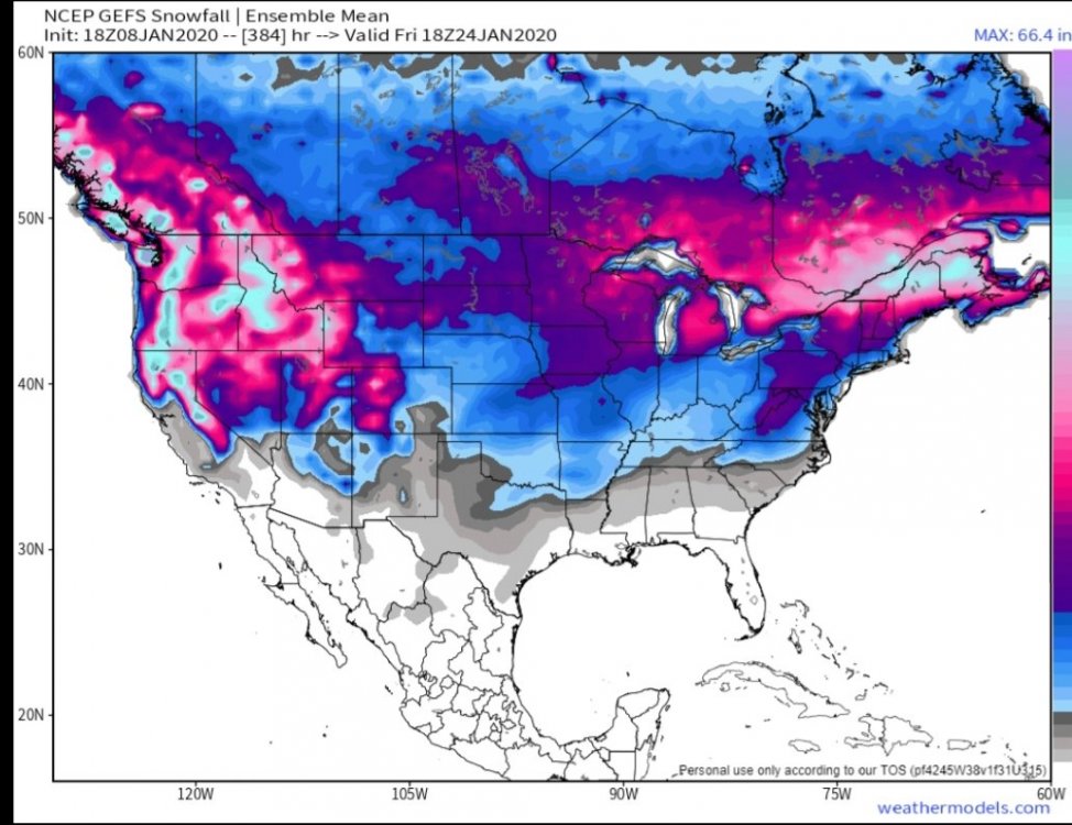
-
December/January 2019/20 Winter Speculation Thread
John1122 replied to AMZ8990's topic in Tennessee Valley
Pretty happy to see the Euro climbing inside 10 days with this. Also good news on the MJO on both the Euro and GEFS. If we can get the pattern to flip in the Jan 15th to February 15th window we should be in business. Big winter events keep showing up in parts of the forum area, usually in these situations the western areas see it first. -
December/January 2019/20 Winter Speculation Thread
John1122 replied to AMZ8990's topic in Tennessee Valley
If we can get through the next 3 days and keep the extended look and reel it in, I'll feel much better about a decent window for wintry weather in the January 17th-30th timeframe. -
I'm at 33 currently.
-
December/January 2019/20 Winter Speculation Thread
John1122 replied to AMZ8990's topic in Tennessee Valley
All day every day on running with a favorable Pacific. It controls everything up stream for us most of the time. If we want cold air it's not easy to come by unless the Pacific is cooperating somewhere. I've seen a bad Pacific blow a -NAO/-AO but I've rarely seen a favorable Pacific spoiled by the lack of those drivers. We had repeat snow and ice storms along with below 0 cold valley wide just a few years ago with nothing but the EPO in our favor. -
December/January 2019/20 Winter Speculation Thread
John1122 replied to AMZ8990's topic in Tennessee Valley
The GEFS is currently the outlier among all modeling. So we have that on our side for now. -
December/January 2019/20 Winter Speculation Thread
John1122 replied to AMZ8990's topic in Tennessee Valley
Not a particularly great model but supposedly better in winter than other season, the CFS turns us to winter and then has 3 snow events in the January 22-30th timeframe. -
December/January 2019/20 Winter Speculation Thread
John1122 replied to AMZ8990's topic in Tennessee Valley
If we can get that look to maintain and roll forward in time we might be on to something. Until it does, it's hard to believe it or the GFS. -
December/January 2019/20 Winter Speculation Thread
John1122 replied to AMZ8990's topic in Tennessee Valley
SEKy, and SWVa look pretty decent for a nice, quick hitter on virtually all modeling. The Euro joins the models that are showing rain on the maps for parts of northern Tennessee but skew-ts show snow soundings. Almost all the models showing the system have 850s at freezing or well below, 925s (2400ft) at freezing or maybe 33, and surface temps in the mid 30s. They all say best guess precip type as snow as well. -
December/January 2019/20 Winter Speculation Thread
John1122 replied to AMZ8990's topic in Tennessee Valley
0z NAM suite is showing snow more in Kentucky but if you look at the soundings the 850s are well below freezing and the precip type on the soundings say snow even in places like Union/Grainger Co where the model is showing rain. Which I believe it is showing because surface temps are mid 30s. So any decent rates will likely fall as snow instead of rain if the NAM is to be believed. -
December/January 2019/20 Winter Speculation Thread
John1122 replied to AMZ8990's topic in Tennessee Valley
The trends of the last 24 hours have all gotten better with that potential system Tuesday with that 3k NAM topping the stack with 2-4 inchs all the way from just East of Clarksville to SW VA. The GFS is confined more to the east but it's snow shield has expanded westward as well. The RAP/RGEM have SE Kentucky in the bullseye. Hopefully todays trends that have put more of us in the potential game continue into future runs.


