weatherwiz
-
Posts
79,954 -
Joined
-
Last visited
Content Type
Profiles
Blogs
Forums
American Weather
Media Demo
Store
Gallery
Everything posted by weatherwiz
-

“Cory’s in NYC! Let’s HECS!” Feb. 22-24 Disco
weatherwiz replied to TheSnowman's topic in New England
Time to get some sleep. Aiming to wake up 2-3 AM or maybe a bit after 1. Gotta recharge a bit -
“Cory’s in NYC! Let’s HECS!” Feb. 22-24 Disco
weatherwiz replied to TheSnowman's topic in New England
Looking at upper level water vapor and mesoanalysis...I think I would be a bit shocked if slides east. In fact, I think this will end up tracking somewhat close to what some guidance was showing 0z/12z yesterday...maybe not quite to the extent but I think some of the east jogs we saw today are overstated -
“Cory’s in NYC! Let’s HECS!” Feb. 22-24 Disco
weatherwiz replied to TheSnowman's topic in New England
So fun to watch
-
“Cory’s in NYC! Let’s HECS!” Feb. 22-24 Disco
weatherwiz replied to TheSnowman's topic in New England
No, they are sometimes issued for wildfires, child abductions, a hazardous spill, etc. -
“Cory’s in NYC! Let’s HECS!” Feb. 22-24 Disco
weatherwiz replied to TheSnowman's topic in New England
very well could be -
“Cory’s in NYC! Let’s HECS!” Feb. 22-24 Disco
weatherwiz replied to TheSnowman's topic in New England
Lets go!!! This is all new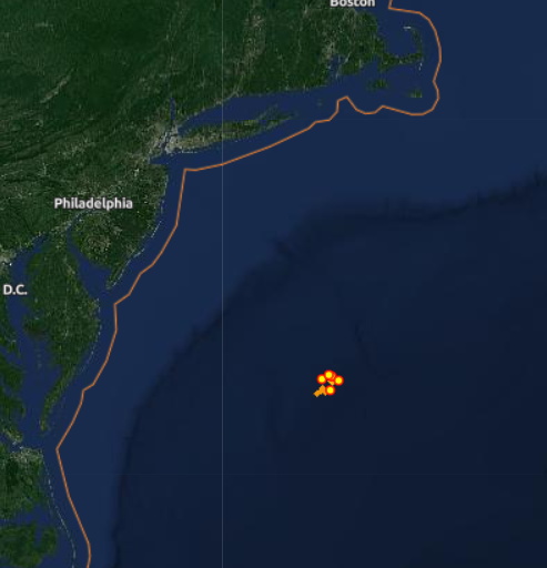
-
“Cory’s in NYC! Let’s HECS!” Feb. 22-24 Disco
weatherwiz replied to TheSnowman's topic in New England
Here's a good visual and this is probably one of the more impressive MAULs you usually see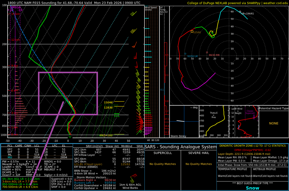
-
“Cory’s in NYC! Let’s HECS!” Feb. 22-24 Disco
weatherwiz replied to TheSnowman's topic in New England
Widespread heavy snow overspreads everyone through the night. Uniform ~30dbz across the state. HRRR also looks to hold onto the snow/banding longer before breaking down than NAM/GFS. Been pretty consistent too with widespread 40-50 mph gusts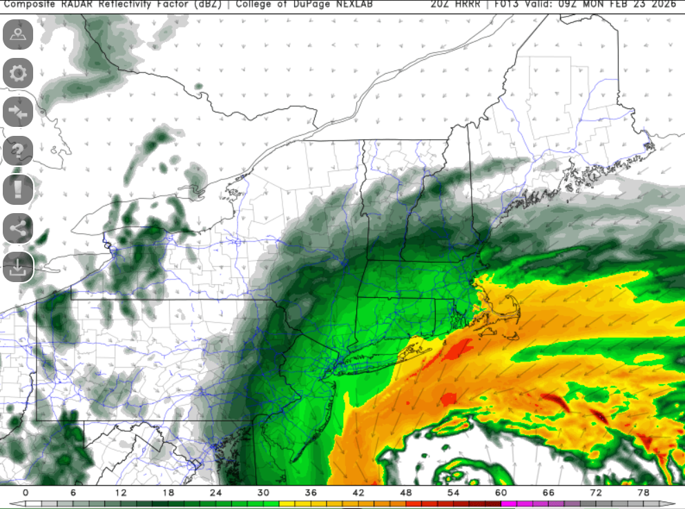
-
“Cory’s in NYC! Let’s HECS!” Feb. 22-24 Disco
weatherwiz replied to TheSnowman's topic in New England
No hate on the 20z HRRR holy moly -
“Cory’s in NYC! Let’s HECS!” Feb. 22-24 Disco
weatherwiz replied to TheSnowman's topic in New England
looks like low topped supercells -
“Cory’s in NYC! Let’s HECS!” Feb. 22-24 Disco
weatherwiz replied to TheSnowman's topic in New England
Pounding in S NJ and DE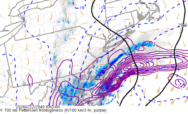
-
“Cory’s in NYC! Let’s HECS!” Feb. 22-24 Disco
weatherwiz replied to TheSnowman's topic in New England
This is going to be extremely fascinating to watch and see how it plays out. What may end up happening too is (and you can kind of see it there) there is enough fire hose to keep the band going but outside of the banding things may wind down quick. That would cause some pretty interesting spreads in totals across a short distance -
“Cory’s in NYC! Let’s HECS!” Feb. 22-24 Disco
weatherwiz replied to TheSnowman's topic in New England
Let's go curling
-
“Cory’s in NYC! Let’s HECS!” Feb. 22-24 Disco
weatherwiz replied to TheSnowman's topic in New England
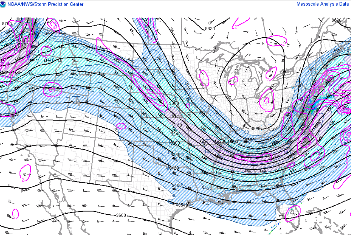
There could be and probably are many reasons but occlusion too quickly would support shutting off the influx of moisture into the storm but that doesn't really look to be the case. Another possibility is with how quickly the storm is strengthening, the best fronto is collapsing south and east closer to the low but that doesn't seem to be the case either because the front just simply dies over us and we seem to be sort of smoking subsidence. I am still leaning towards this being completely overstated but if this happens we can't say we're surprised by it lol -
“Cory’s in NYC! Let’s HECS!” Feb. 22-24 Disco
weatherwiz replied to TheSnowman's topic in New England
This has had me scratching my head -
“Cory’s in NYC! Let’s HECS!” Feb. 22-24 Disco
weatherwiz replied to TheSnowman's topic in New England
I'm going to install giant windmills in my backyard so I get thundersnow every time -
“Cory’s in NYC! Let’s HECS!” Feb. 22-24 Disco
weatherwiz replied to TheSnowman's topic in New England
Well not making any changes. There will certainly be some screw zones but no way to quantify that.
-
“Cory’s in NYC! Let’s HECS!” Feb. 22-24 Disco
weatherwiz replied to TheSnowman's topic in New England
Thank you! -
“Cory’s in NYC! Let’s HECS!” Feb. 22-24 Disco
weatherwiz replied to TheSnowman's topic in New England
WOAH Blizzard warning for me. LETS GOOOOOOOOOOOOOO!!!!!!! -
“Cory’s in NYC! Let’s HECS!” Feb. 22-24 Disco
weatherwiz replied to TheSnowman's topic in New England
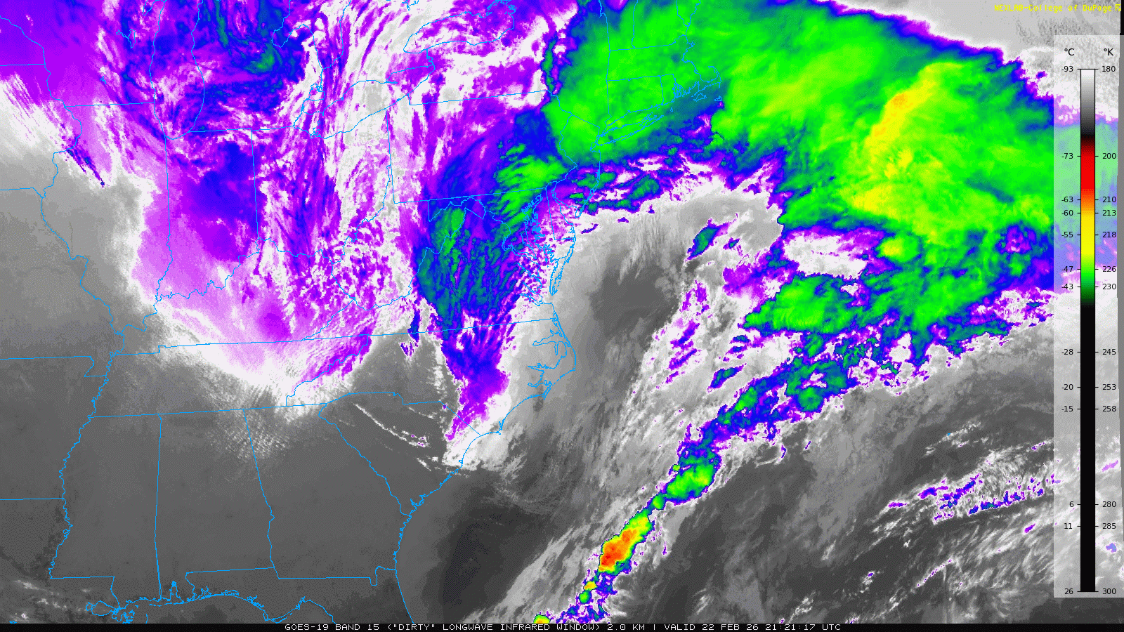
At this point it's time to really shift focus to satellite, radar, and mesoanalysis/HRRR -
“Cory’s in NYC! Let’s HECS!” Feb. 22-24 Disco
weatherwiz replied to TheSnowman's topic in New England
Thanks for posting this. It seems the 3km NAM is always aggressive with precipitation and development, especially on leading edge of approaching weather systems and out ahead of fronts. I am guessing this is part of its scheme where it just develops precipitation too quickly? I can think of the terminology here but I did a module on MetEd last summer that went into this. -
“Cory’s in NYC! Let’s HECS!” Feb. 22-24 Disco
weatherwiz replied to TheSnowman's topic in New England
I haven't see this talked about much but what I think is really going to be a killer in this is going to be areas of major subsidence. I've always been fearful we see a banded precipitation field given how intense the low becomes, but none of the simulated radar reflectivity's have shown this. However, I think it's kind of evident in looking at the fronto banding signatures. Ultimately what will happen is there will be spots which make out beautifully and score in the upper end of ranges and there will be spots which struggle to even get to the lower end. No way to really paint that on a map either -
“Cory’s in NYC! Let’s HECS!” Feb. 22-24 Disco
weatherwiz replied to TheSnowman's topic in New England
Hellebuyck is the MVP, 1st Star, 2nd Star, and 3rd Star -
“Cory’s in NYC! Let’s HECS!” Feb. 22-24 Disco
weatherwiz replied to TheSnowman's topic in New England
SCORE!!!!!!!!!!!!!!!!!!!!!!!!!!!! -
“Cory’s in NYC! Let’s HECS!” Feb. 22-24 Disco
weatherwiz replied to TheSnowman's topic in New England
That's what I'm thinking. It's very bizarre.