

weatherwiz
-
Posts
81,082 -
Joined
-
Last visited
Content Type
Profiles
Blogs
Forums
American Weather
Media Demo
Store
Gallery
Everything posted by weatherwiz
-
 Probably gusts 30-35. No thunder or lightning
 -
Really shocked the warnings got extended
-
There goes the curl booo
-
There's the warning
-
Nice core on that Belchertown cell. 60dbz to 20K on BOX
-
ahhhh...I was just thinking about this earlier and if it was MLCAPE or MUCAPE to follow...couldn't remember
-
Will be interesting to see how this progresses because the stronger instability will continue building east towards the CT River along with the ridge building too
-
gotta say...its a bit more unstable than models were forecasting in our region today
-
yeah that complex is going to ride the instability gradient. outflow def could fire stuff up farther east
-
How dare it get to 100F in summer
-
I find it to be alright...I don't think its anything truly groundbreaking over traditional MOS. What can be very valuable about it is how it provides temperatures based on percentile which can be a huge asset in highly anomalous patterns. For example, I think it was a couple years ago when they were getting very big heat in the West I remember some places where the 90th percentile which was verifying over the typical median which is spit out. I think it absolutely sucks though along boundaries, which I mean can be expected to a degree, but it almost always, always to favor towards the warmer side of the boundary. I've seen NBM bust by like 15F because it had the warm front blowing through and that never happened. I also like how it does not have the limit of reporting cloud cover...so it will pick up on the high clouds while traditional MOS will spit out CLR
-
Going to end up with convective cloud debris today too and may even see convection begin to pop early afternoon...or maybe closer to mid-afternoon. Pretty healthy looking convective complex (at least from satellite presentation) in Quebec racing southeast
-
Even the GFS has a quite a bit of elevated CAPE with at least western sections on the instability gradient. It will be an interesting evening/overnight, especially if the NAM sort of verifies with the advection of rather impressive MUCAPE. The HRRR I think has been solid with the idea of convection moving into the region this evening but I think this may end up being a bit more impressive than modeled. These are tough environments, even more mesos to handle
-
Bring it baby
-
Just an insane presentation still. Even looks like there may be a rain wrapped tornado
-
I don't know if I would necessarily bet against it, however, I would put forth some caution into the extent of what some of the forecasts are in terms of its strength. I think its just way too premature to start tooting around x,y,z are happening because we have a super-strong that is developing. I still don't necessarily see how a lot of comparisons can be drawn to how the atmosphere is responding to something developing, particularly when it comes to the ocean. There is quite a time lag between ocean-atmosphere response. It's not like the atmosphere is going full EL Nino mode because the ocean is warming...there will be some time before that warming in the Pacific has a full-fledged impact on the atmosphere. For example, most EL Nino's, particularly stronger ones will tend to peak during the Fall at some point and begin to weaken moving through winter, but its not until the winter months in which you see a much stronger correlation to the impacts of EL Nino.
-
It's more of the fact that everything is being blamed on something which has not yet become established and its not like these episodes of heat and large ridges are solely a response to EL Nino.
-
Absolutely ridiculous. So extra heat is being added from something that isn't established yet and is only in the developing states?
-
Correct, I should have been a bit more clear with this aspect
-
was looking at vorticity rolling through/shear/instability...but mostly focusing on the shortwave rolling through as the driver for anything. If that shortwave is nothing or relatively weak then yeah we won't see much of anything
-
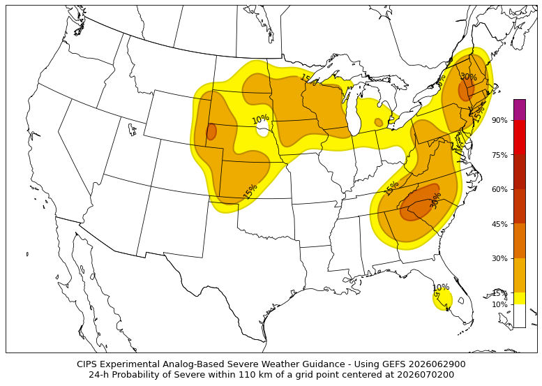
Actually I kind of like where that has the 30% area for D3. Looks like the instability gradient (talking about gradient between moderate and extreme instability) may be eastern NY into western New England. Something to watch because any development, particularly any cluster or complex, is going to ride that
-
Not bad for a D3
-
True, height falls are relatively meager. Certainly one of the negatives to consider
-
Looks like right along the theta-e axis. What happens tomorrow night could end up setting the stage for Wednesday too, particularly when it comes to any potential remnant outflow boundaries. We'll have to see how things time with shortwave energy and even shortwave strength but Wednesday has potential to be a higher-end severe day I think
-
Wednesday looks pretty solid


