weatherwiz
-
Posts
81,082 -
Joined
-
Last visited
Content Type
Profiles
Blogs
Forums
American Weather
Media Demo
Store
Gallery
Everything posted by weatherwiz
-
 Does anyone subscribe to weatherfront? I’ve been looking at that for quite a while. Been debating on doing the highest tier for radar scope for $100/year but weatherfront may be the edge given it has models
 -
There almost needs to be a separate scale for the Northeast. The impacts are not equal to other regions. Sure other regions get the higher end severe and more significant, however, a you can get a squall line rip through the Northeast and result in >50,000 power outages and put that line of same strength through the mid-west and barely get 20,000 power outages. Lots of reasons for that obviously but impacts here can be greater just because of population density and trees and how the power grid is configured
-
Agreed. The more I dig into the changes and thought about it, the changes are a great positive. The number of moderate risk/high risk issuances should be reduced and only conserved for events that hold true significant and widespread potential. And for our area at least, we maybe get those type of setups with that potential maybe once every five years, if lucky. Probably closer to 1:7.
-
crazy to think a 45% sig 1 is still only an enhanced. We may never even see a moderate risk in our area again
-
it's winter in the summer. Someone seems bound though to get some good rains but I'm a little skeptical of widespread amounts that high like the NAM has.
-
That is going to be they key I think to where the heaviest totals occur. Have to see where that sets up but sort of seems like that may be just north of SNE. We get into the heavy rains as it moves through but this might be maximized just north. I foresee one big band of rain lifting north then more showery
-
I think that is way overdone on a widespread level. I do think there will be a max of something along the lines of 3-4" but I don't think we're going to see widespread 2-3" amounts from this.
-
Kind of a strong smell of smoke out there this morning.
-
Damn only 45 knots. Looks like the core just missed
-
Let’s go 55 knots there
-
Damn only 2 off
-
My guess is EWR will measure 64 knots
-
There is nothing like sitting outside with an IPA and listening to the AC’s hum hummmmmmmmmmmmmmmmmmmmmmmmmmmmmmmmmnnnnnmm its music baby
-
I am kind of hoping the activity will cluster enough and develop a cold pool to survive on and lead to some downstream development
-
Stuff really blossoming quickly. May bode well for western/central Mass/CT this evening. Activity developing right along the edge of stronger westerly flow aloft and in an environment characterized by 2500 J of MLCAPE and on the edge of an EML. Stupid westerly flow and deeper mixing here though is resulting in lower MLCAPE but maybe we can bring dews up a bit this evening
-
An area of blossoming convection between Rocester and Binghamton which the HRRR didn't really have. Looks like some convection about to fire too northwest and west of Albany
-
hmmm well a Great White Shark can come swimming through and fart and that would probably mix the water temp back down into the 60's
-
Looks like the HRRR is already busting for today
-
yeah but what's the depth of those temperatures?
-
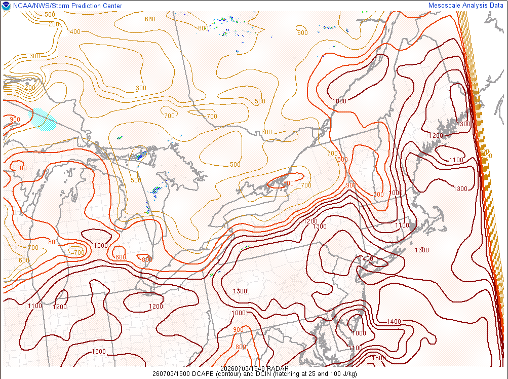
Crazy spread in CAMs today with convective coverage. The shitty W/WNW llvl flow really blows for coverage. But if we do see any storms enter the region they could pack quite a punch. The llvl flow is very weak but DCAPE values are absolutely nuts
-
Looks like they pulled 87...absolutely insane. NBM was not far off on that...much closer than GFS/NAM
-
This month is going to be a scorcher. We'll get some breaks in the higher heat/humidity...I mean we're at the mid-latitudes so fronts will be coming through but those breaks will be brief. Looks like we could get at least one day of 90's towards the end of next week (maybe two), then a front goes through and we drop off again (still seasonably warm) and then could be looking at another push of high heat/humidity
-
Nice downburst looks line over Hudson, NY
-
So sick of these stupid YouTube clowns with their stupid thumbnails of "get ready". Like to smack them across their stupid looking faces with their stupid microphones
-
QPF can't be taken at face value during the warm season (unless you're dealing with a clear-cut and well-defined synoptic lift event). When you're dealing with convection, guidance (especially less coarse models) are going to whip up erroneous QPF amounts over a widespread area when the reality is you're looking at convective precip which is going to be more hit and miss.