

weatherwiz
-
Posts
79,817 -
Joined
-
Last visited
Content Type
Profiles
Blogs
Forums
American Weather
Media Demo
Store
Gallery
Everything posted by weatherwiz
-

Blowvember - and not named for wind potential
weatherwiz replied to Go Kart Mozart's topic in New England
I don't know about that. I mean maybe here on this place, some people don't but I still question that. More times than not storms get hyped up 6-7-8 days out because the snow maps go bonkers and literally 95% of the discussion revolves around the 10:1 and Kuchera maps from 20 different models, 3% of the discussion is actually looking at and applying meteorology, and the other 2% consists of back-and-forth bickering because person A isn't happy with where they are with respect to the storm so cry bust while person B is very happy and calls overperformer because they got crushed. -
Blowvember - and not named for wind potential
weatherwiz replied to Go Kart Mozart's topic in New England
How about we just make our own snow maps!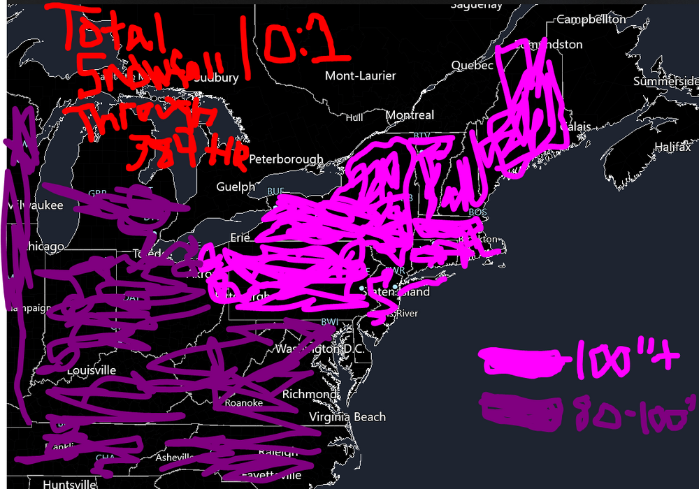
-
Blowvember - and not named for wind potential
weatherwiz replied to Go Kart Mozart's topic in New England
Agreed, I always thought that some of that stuff was overplayed...like the snow cover in southeast Canada, lack of snow cover on the ground here, etc. Sure there is some influence, but it isn't going to have any bearing on the overall pattern. If the pattern is in place and you have favorable shortwave evolution and interaction, who cares if there is or isn't snow pack across southeast Canada or our region. -
Blowvember - and not named for wind potential
weatherwiz replied to Go Kart Mozart's topic in New England
I guess this could be posted in the December thread, but one thing that hopefully works in our favor moving through the first half of December is a less chaotic flow and pattern which are loaded with shortwaves. A huge part of the reason why guidance has struggled so much, particularly ensembles is the barrage of shortwaves. One model run and one model would highlight one shortwave as the main player while another model choose another and it was just constant flip-flopping. The northern stream should offer us plenty of chances for clippers and/or re-developing clippers off the coast. Looks like we may lose some STJ for a while, which isn't a bad thing at all but once we get a bit of a STJ connection going again, as long as we continue with the troughing signal in the East, we'll open the door for coastals. -
Blowvember - and not named for wind potential
weatherwiz replied to Go Kart Mozart's topic in New England
I'm really not sold on much for this end of the week. It's just a cold front coming through with a weak wave developing along it. There certainly is room for a second wave to develop Thursday night/Friday morning but I don't think its going to be a situation where NNE has any room for snow (reason being QPF will be farther south). It's either going to be rain for SNE or the second wave develops even farther south and we get little QPF, outside of the coast. -
Blowvember - and not named for wind potential
weatherwiz replied to Go Kart Mozart's topic in New England
yeah definitely going to be on the slick side up your way. This is why when I complain about how shitty winter is...I have to remember to indicate I'm talking about down here. Even in the most garbage regimes, you NNE'ers still find way's to get wintry precip -
Blowvember - and not named for wind potential
weatherwiz replied to Go Kart Mozart's topic in New England
Should be a nice little drink for everyone tomorrow. Certainly not enough to cut into the deficit really but something. -
Blowvember - and not named for wind potential
weatherwiz replied to Go Kart Mozart's topic in New England
That could be some serious lake effect snow around Buffalo Saturday with thunder...maybe waterspouts too. Snowadoes comin' -
Blowvember - and not named for wind potential
weatherwiz replied to Go Kart Mozart's topic in New England
Kind of sucks that shortwave is trailing by so much coming across the Lakes. But then again...with our luck any interaction would proably just net cyclogenesis in the HV -
Blowvember - and not named for wind potential
weatherwiz replied to Go Kart Mozart's topic in New England
Nice!! -
Blowvember - and not named for wind potential
weatherwiz replied to Go Kart Mozart's topic in New England
the clouds -
Blowvember - and not named for wind potential
weatherwiz replied to Go Kart Mozart's topic in New England
yeah the clowns were going insane. I got shafted big time here with that band setting up over northern or central Connecticut. That was the white flag for me with winter. But that's what these snow maps do...they truly are ruining the field. They are used all over and everywhere. It's all about hype, ratings, likes, and mentions. Too bad NOAA doesn't have any authority to ban those garbage products from being created. -
Blowvember - and not named for wind potential
weatherwiz replied to Go Kart Mozart's topic in New England
yeah same storm but like Scott said not that dramatic. I forget what some of the forecasts were for Boston but I want to say the consensus forecasts were like 8-12''? -
Blowvember - and not named for wind potential
weatherwiz replied to Go Kart Mozart's topic in New England
This has probably been frustrating above anything else. The model agreement has been dogshit and the ensembles have been just as bad...they've lead to several "high confidence" forecasts for some storms 3-5 days out, and the snowfall forecasts start flying, winter storm watches/warnings start flying, and then everything falls to crap the last minute. Then of course we had the Feb 5(?) debacle where Hartford county went from a winter storm warning to advisory only to get over a foot of snow widespread lol. -
Blowvember - and not named for wind potential
weatherwiz replied to Go Kart Mozart's topic in New England
llvl lows developing and tracking to our south and this is what we can muster up for 925 temps But that is some serious llvl cold behind this...definitely concerned with some degree of suppression, however, we could be in game for clippers.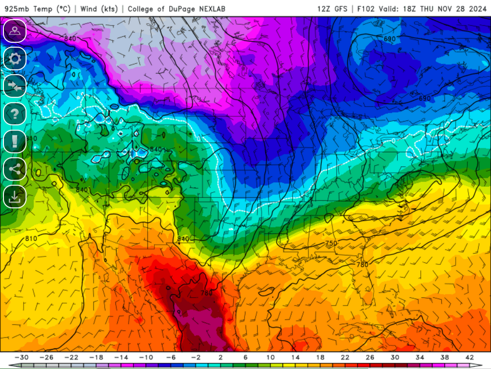
-
December 2024 - Best look to an early December pattern in many a year!
weatherwiz replied to FXWX's topic in New England
There seems to be a degree of spread within the strength of the MJO but perhaps the MJO strength will be too weak to have much of an impact or influence on the overall pattern, especially if that northern PAC domain verifies as is. -
Same...I'm down for the December one, whatever the date is.
-
Blowvember - and not named for wind potential
weatherwiz replied to Go Kart Mozart's topic in New England
west-northwest to northwest flow over waters which I'm sure are still quite warm with 850's -12C to -13C...that would be some wild instability. -
Blowvember - and not named for wind potential
weatherwiz replied to Go Kart Mozart's topic in New England
I would love to experience something like that but I'm fearful I will be airborne -
Blowvember - and not named for wind potential
weatherwiz replied to Go Kart Mozart's topic in New England
Could be some pretty intense LES this weekend...hell could be a pretty prolonged and prolific event. -
Blowvember - and not named for wind potential
weatherwiz replied to Go Kart Mozart's topic in New England
I wonder what its like in the Plains or like Montana when they get big wind events and are sustained 50-60 mph and gusting to 80. That must be fun -
We should also try and do one during the spring
-
December 2024 - Best look to an early December pattern in many a year!
weatherwiz replied to FXWX's topic in New England
I know we don't need southern stream energy to get storms but I would like to see signals of a bit more active southern stream. It is nice seeing a PV lobe (or multiple pieces) hanging around in southeast Canada so the one thing to watch for that is any shortwaves which may swing through our region. If you just look at SLP/QPF maps for storms you can often miss these because sometimes a storm won't "pop up" until like 2-3 days out while the signal where there at H5 for 4-5 days. But we keep that PV energy around and get a southern stream vort to ride the coast... -
Blowvember - and not named for wind potential
weatherwiz replied to Go Kart Mozart's topic in New England
What I'm also worried about too is and this is exactly what you said the other day...now we could run into issues where the vorts are shredded I probably jinxed that because I said the look didn't really seem like something where that would happen. -
Blowvember - and not named for wind potential
weatherwiz replied to Go Kart Mozart's topic in New England
That is one helluva change from 18z versus 12z in that H5 evolution mid-to-late week holy cow.


