weatherwiz
-
Posts
81,150 -
Joined
-
Last visited
Content Type
Profiles
Blogs
Forums
American Weather
Media Demo
Store
Gallery
Everything posted by weatherwiz
-
 ha, we may have clicked on just about the same area lol...I saw that and was like, "woah". But damn...the NAM also wants to really drive in that drier here, if you forward that 3 hours...huge difference. I get the brunt of the snow falls before that happens but this could be critical when it comes to achieving the upper end of forecast ranges.
 -
This is a terrible snipping tool job but hockey is about to come on so don't have time to illustrate this on a map but I would watch for two jack areas...one through south-central Connecticut and then up along MA/VT/NH border...these two zones may see totals push the 7-9" range. In between these two areas I wouldn't be surprised if 4-5" is more common. It's basically a quick hitting wall of snow then kind of poop....but it is going to be amazing under that wall.
-
Well making no changes to my forecast rom the other night after finally getting a chance to look at things closely today. Forecast soundings and bufkit look great for a good 2-3 hour period of heavy snow to get just about everyone. There is definitely room for some 7-10" totals north of the Pike but not adding an area for that.
-
Gotcha, I did have some worries that because the duration of those heavier rates looked relatively short whether the common totals would be more of 4-5” versus 6-7”. And Outside of the fronto bands I was a little worried we won’t accumulate efficiently.
-
What? I said same growth and rates would be great under the heaviest fronto bands (1” per hour rates) with ratios 12:1 to 15:1 and even out that in the discussion in the blog post I posted with my forecast. I said outside of this the rates and ratios could be poor or snow growth could struggle
-
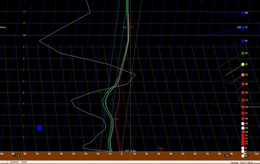
Yeah I wish I was on my laptop so I could fire up bufkit soundings for the HRRR. I guess maybe H7 temps could be warm enough to where if lift and snow growth is awful we get crappy flakes and sleet like. Not sure I buy that though but something to watch for
-
That’s kind of what the hrrr looks like
-
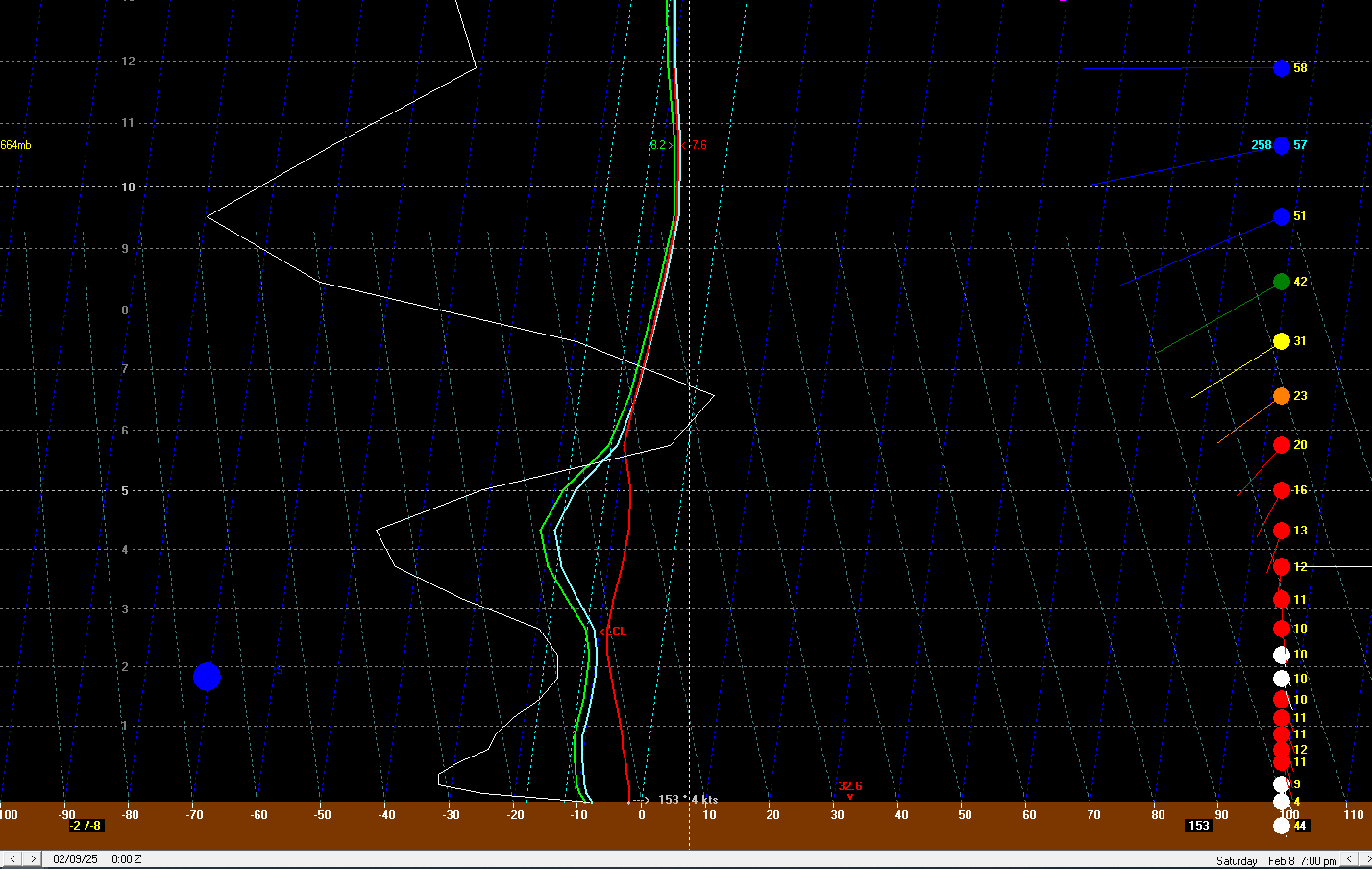
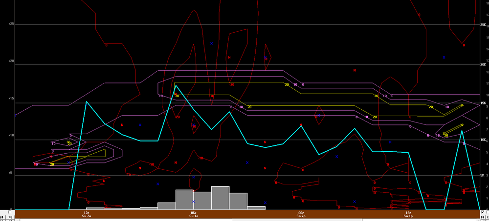
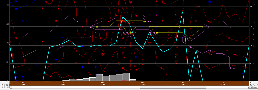
18z NAM bufkit certainly rips at BDL for a good 3-4 hours. But it also really likes the ratios too under the stronger omega. That's some pretty hourly rates there
-
Much liking the structure of the precip shield too on the 3km. Very uniform distribution of dbz and not crappy dbz either
-
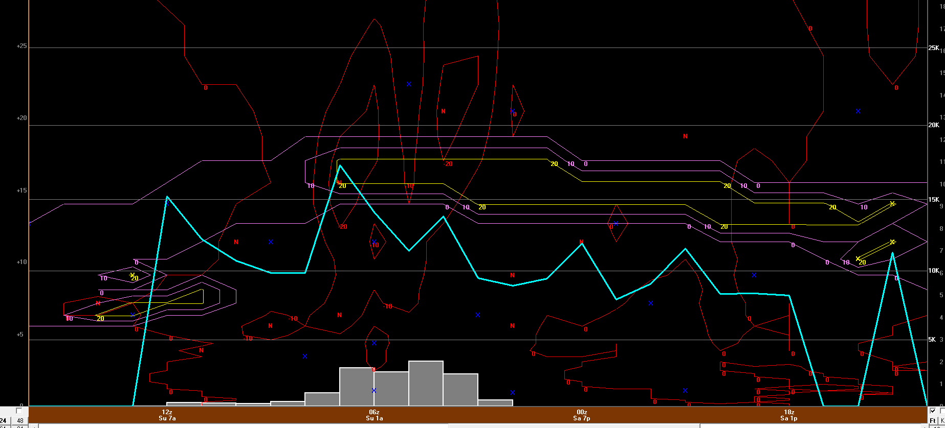
Even some kinking going on at 700. But that's a nice H7 fronto band that develops...probably a bit too late down in Connecticut but this would bode well probably Pike on north...that's where there is a good chance for some widespread 6-8" totals

-
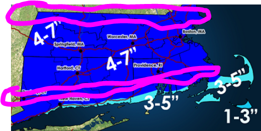
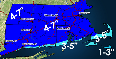
Well here is the 12z GF bufkit for BDL. I'll just stick with my 4-7" forecast though I think 4-5" amounts will be the more common across Connecticut with the best chance for 6-8" totals northwards (like where Scott mentioned). But you can see that the window for heavy snow/highest rates is confined to a very small window and and outside of the greatest lift there isn't a whole heck of a lot.
-
That's true but for those in the snow removal business or planning...that is a big difference. I am not involved in that vertical but I have a few friends who do snow removal and one will ask me for some thoughts here and there. He says when he sees ranges like 2-5" or even something like 4-8" or 5-9" it can make decision making difficult for him...planning on how many people to call in, exactly what type of equipment to use (including using plows on trucks), how much sand/salt, etc. He says the worst is the 2-5" range because that is the difference in just using shovels versus needing snow blowers and extra gas.
-
IMO, 6" is the ceiling for most. Anything above 6" will be the result of getting under multiple heavier bands. I think 4-5" amounts will be the most common across the board, but those areas that get lucky will end up with the 6-7" totals but that won't be widespread, that will be confined to a specific area. I mean looking around any various soundings on bufkit outside of the heavier fronto band the upward vertical motion is not particularly great. Now, the DGZ may be just low enough to where that could help compensate some but when I am looking at bufkit soundings and looking at omega, coupled with the DGZ and the snowfall ratios, I am asking myself, "what is the snow growth going to look like and what will the rates be"? Under the fronto band...1" per hour is obtainable but outside of that...may be lucky to push 0.50" per hour. Also, look at the duration of the lower omega values into the DGZ...its an extremely small window. WAA induced snow without a stronger forcing mechanism typically does not bode well for creating dendrites which accumulate efficiently.
-
6z gfs bufkit certainly argues this for Connecticut looking at multiple locations. If I have energy/time later today I'll probably make a revised map and drop the 4-7 to 3-6. There probably will be some 6-7" totals though, maybe north...difficult to say because that will be tied into the H7 fronto banding.
-
ehhh...if one takes the time to really digest everything, assess forecast soundings, evolution of low-levels and mid-levels, and then applying knowledge of these setups well there are plenty of flags which show what you're suggesting isn't far-fetched. Every single weather system is going to have flags and its important that flags be pointed out and assessed to determine what impact those flags would/could have. More often that not, red flags are going to have some impact on what occurs, otherwise every single weather system would overperform.
-
We seem to have short memories and aren't great at learning from mistakes. Or we get too caught up in stuff like QPF and then of course tossing in snow maps like they're worth a damn. But something of 2-4 somewhere is absolutely 100% doable. It's also not like we're getting several hours of intense lifting through the DGZ and even looking at bufkit soundings, outside of the periods where you're maximizing lift the snow ratios aren't anything spectacular. Outside of maximizing lift, snow growth and ratios will probably be meh. I promise you'll see several posts commenting how awful they are.
-
I feel kind of dumb. With the other day system I think it was @HoarfrostHubb who made a comment saying one of the models might be overdone with QPF but I said I think it was right...I didn't end up following the whole evolution too closely but I am going to guess that was overdone with QPF. Anyways, my point is, when looking at this setup it's important to understand what mechanisms are involved for the QPF production. We do have the strong diffluence aloft which is helping to net some upper-level divergence, but the overall driver here in QPF production is probably the WAA and llvl frontogenesis. That may and should yield some caution, not just with total QPF but QPF structure and how that QPF is being utilized (i.e. we're going to have to relay on pockets of enhanced VV to maximize snow growth and ratio). damn it...I should have went 3-6...maybe 3-5.
-
We get too quick to toss the NAM, especially when its shows what we don't want to see.
-
I am a little nervous about my widespread 4-7" forecast...I was debating on doing 3-6"...I know there really isn't a difference between the two but when you look at the "how you're getting there" and the mechanisms involved, IMO there is a bit of a difference between the two.
-
Getting a cute little snow flurry right now
-
edited
-
Well 2.5” from the other day, I didn’t get a chance to measure today but eyeballed probably about an inch (maybe 1.5”)…but I’ll call it an inch. so that’s 3.5” since Sunday. If I can pull off the 7” in my 4-7” forecast that brings me to 10.5”. would only need 49.5” to hit my goal of 60” for this stretch by mid March
-
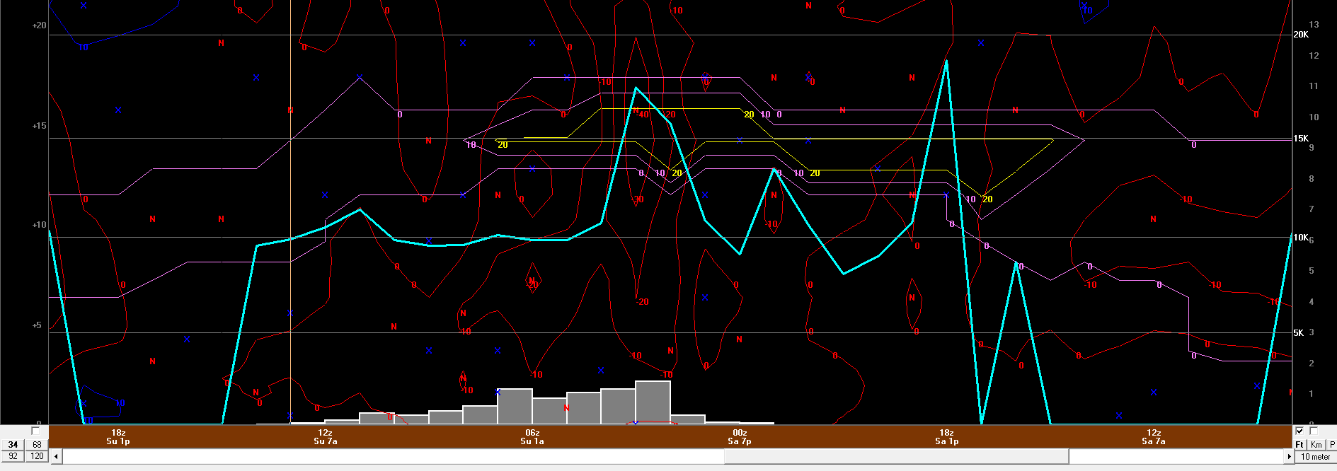
Well got the opportunity to dig deep into the details for Saturday into Sunday. Ultimately, one concern I have for higher totals is just the forward speed and the duration the best lift/maximized snow growth is. I could end up seeing some 7-10" amounts possible though but not widespread enough to map and that will be tied into very localized areas of enhanced lift. https://weatherwiz.blogspot.com/2025/02/february-8-9-2025-southern-new-england.html

-
Tracking February 6. Light to moderate event potential
weatherwiz replied to Typhoon Tip's topic in New England
Think we're getting freezing rain now. -
Tracking February 6. Light to moderate event potential
weatherwiz replied to Typhoon Tip's topic in New England
well technically you're right, it is rain. It doesn't fall as freezing rain, the freezing occurs when it comes into contact with a sfc.