-
Posts
80,247 -
Joined
-
Last visited
Content Type
Profiles
Blogs
Forums
American Weather
Media Demo
Store
Gallery
Everything posted by weatherwiz
-
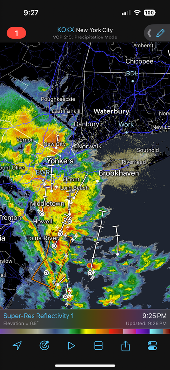
Maybe a nice little light show? Looks like the edge of the elevated instability is pushing towards the shoreline. Wonder if there could be some small hail in these
-
BOOM. My girlfriend is on the FaceTime with a friend who lives in New Jersey in a highrise building and he has the camera facing outside and we saw a sick CG!!!
-
Right
-
made a thread! Who doesn't want to begin the year with damage
-
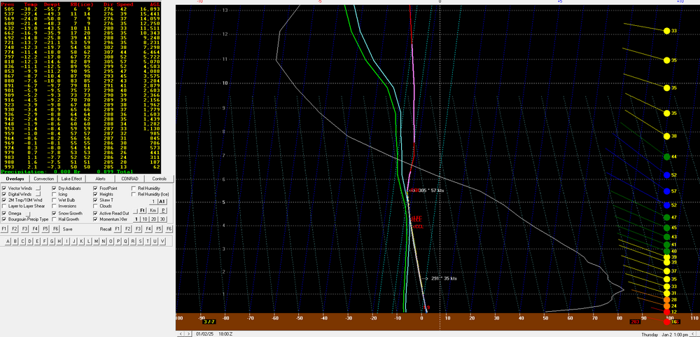
As one of Eminem's songs states, "Cold Wind Blows" and it will be blowing on Thursday. An area of deepening surface low pressure moving northeast across the region Wednesday into Thursday, combined with a large high pressure system building into the mid-South yields a strong pressure gradient across the Northeast Thursday. 925mb winds are expected to be greater than 40 knots region wide with 850mb winds exceeding 50 knots (while weakening through the afternoon). Forecast models indicate the presence of very steep low-level lapse rates region wide with a lapse rate within the lowest 5,000 feet of the atmosphere up around 9 C/KM, indicative of strong low-level mixing. Bufkit model soundings from both the GFS and NAM indicate the potential for widespread wind gusts of 55-60+ mph with sustained winds anywhere from 15-30 mph. While widespread wind advisories are already in place, I would not be surprised if we see some upgrades to a high wind warning over the next day. While the trees are bare which will limit the potential for damage, due to the magnitude and duration of strong winds, scattered power outages are likely along with some downed trees and limbs. There also may be a nice localized pocket of light-to-moderate snow within the Greens of southern Vermont Thursday which could net several-plus inches of accumulation. 12z NAM bufkit for BDL Thursday afternoon. Don't see NAM outmix the GFS too often
-
This is one of the more impressive wind signals we've had in a while I think. The trees are bare so that limits damage potential but there will be some power outages and downed trees.
-
Thursday is going to rip. I also don't recall many times seeing the NAM outmix the GFS. Wonder if we eventually see wind advisories converted to high wind warnings. BDL
-
Wasn't a bad day today. Went outside a bit on a quick lunch before the Bruins game to pick up dog poop now that the grass is fully visibile again...boy was there alot of dog poopy. I looked like Santa carrying his giant sack of gifts
-
wow so we actually have a decent shot to see above-average snow then. May February is Dreambruary for us
-
That's something we're going to have to watch closely...confluence is going to be huge too but we can't lose track of what is happening within the Southwest with the energy and this seems to be an area where models can struggle drastically. Like I mentioned the other day...this could end up being something which gives us a big boost or totally screws us.
-
I really hope the 8th-12th time frame can pan something out. I don't feel very confident or very good about our prospects once the pattern relaxes. I feel like most of the bullets will have been used up by then and once the pattern relaxes its an inactive storm track. But hopefully the relax of the pattern will come with another reload and not a relaxation then do a warmer pattern.
-
crack may actually have more value than snow maps.
-
can we ban posting snow maps beyond 5 days out???
-
Perhaps a shitty evolution or scenario on the 6th opens up more room for something around the 10th
-
One thing too with the 8th-12th time frame is there is some major uncertainty with that energy in the southwest. I bet that is going to end up playing a huge role in whether we're looking at an interior Southeast/mid-Atlantic special or northern mid-Atlantic/Northeast ordeal.
-

New England Winter 2024-25 Bantering, Whining, and Sobbing Thread
weatherwiz replied to klw's topic in New England
Hey @dendrite remember the picture of that massive spider I posted back in like August that was outside above the AC unit and you don't me, "don't you dare kill it?". Well it had remained within the window ever since, even after I uninstalled. Unfortunately, it is now a popsicle, it looks like its frozen and dead within the window sill. I'm kind of sad actually. It just stayed in its little home all these months. -
I think everyone needs to go to the local package store and grab a 40 of Steel Reserve. I may do that soon. I’ve only had two Steel Reserves since December 2018…might need to re-introduce them back.
-
I’ve driven myself so nuts these last 3-4-5 winters that I think I just look for the bad as a coping mechanism but in all seriousness…these last several winters have pissed me off. I am so sick of looking in the extended and seeing patterns which are “favorable”. I would have a friend who does landscaping text me once in a while (he follows a lot of different weather sources) and when he would catch wind of something he would text me, “what’s your thoughts?” And I would say, “yeah I’m super excited, this looks good and favorable for snow”…then nothing would happen. It just became embarrassing and quite frankly pissed me off. So this has driven me. maybe 20-30 years ago you would just look at the pattern in the extended and just derive some thoughts based off the pattern, but we’ve come along way in this field. Perhaps this is just wishful thinking by me, but I am a firm believer we’ve come far enough in this field to where we can go further with just pattern assessment and just quickly say the pattern looks good based off blue colors in the East. We’ve seen enough of these “good” pattern not to produce to the point that we can all sit back and be like, “alright what’s going on here?” Obviously a reason here is how the pieces evolve and interact within the pattern but I fully believe we can sniff that out well ahead of time in some cases.
-
Those heights get any lower and you can probably kiss the stratosphere at the base of Mount Washington.
-
Most of these weather Youtubers are awful, however, unfortunately they are mastering the game. They know exactly what gets clicks and subscriptions and unfortunately some of them are probably making some damn good money from this stuff.
-
I really hope it works. Even if it doesn't we still have the rest of the month and February (even March) which can always deliver but if this winter ends up another dud...then I really hope we can start stringing together some neutral ENSO years. The entire atmosphere just needs to be flushed. This back-and-forth of Nino/Nina sucks. I bet if we had the neutral ENSO background state and got the good PAC/Arctic looks we would be cashing in handsomely or at least having seasons closer to average.
-
This is going to feel like the longest two weeks ever. We still have like another 5-6 days before that period gets around D5
-
What's wild to think about is if we were to get a March '06 or '12 redux, we're only two months away from getting 70's and 80's
-
I hate these features because they can really muk things up and its very difficult to have an idea of its influence.
-
Probably an unpopular opinion but I want to go back to the days of injecting southern stream shortwave energy up the coast and more of a bonus with northern stream phasing. I know we don't need southern stream energy to get storms up here and even big storms but the northern stream alone isn't doing jack shit for us. I'm curious to see if that cut-off low southwest of California is either going to help us or royally screw us...or maybe best case not be much of a factor.


