

weatherwiz
-
Posts
81,150 -
Joined
-
Last visited
Content Type
Profiles
Blogs
Forums
American Weather
Media Demo
Store
Gallery
Everything posted by weatherwiz
-
Bingo, agreed
-
Its unfortunate how such a topic has been approached and then conveyed. It is not about the science, unfortunately. This is what happens when information falls into the hands of the wrong people. I 10000% agree with you the globe warms and cools and its always been that way but the concern is the acceleration of this warming period. Unfortunately for something like this the best course of measure would be for one to conduct their own research and not listen to the media.
-
but why is it a crock of crap. Also, there is more to it then just temperatures and precipitation.
-
I'm actually fine with the differentiating between the two. IMO, climate change and global warming are two very different beasts. By definition, all global warming means is the average increase in the Earth's temperature. And since coming out of the last ice age, the Earth has been on a warming trend, however, the argument is the warming is being accelerated and this is what then has branched into the climate change aspect. Who cares if the warming is attributed to natural cycles, human activity, a mixture of both, or because aliens on Pluto are directing lasers at us. Maybe climate change isn't a good term though. But with global warming, that doesn't mean every single location is warming or there can't be any cold. there still needs to be a balance so if its anomalously warm somewhere, chances are it needs to be anomalously cold somewhere...otherwise the Earth's energy budget and balance would be severely disrupted. but I guess one argument can also be this budget is already severely disrupted...the balance is off.
-
But climate change does not mean it can't snow or be cold anymore...and it doesn't mean that places that don't typically get snow can't. That's the problem...99% of people don't understand what climate change means. anyone who thinks this or believes this is extremely misguided.
-
Not just water vapor, but CO2 as well. As I'm sure you know, both are excellent absorbers of longwave radiation, which the Earth's surface emits. But regardless of whether the Earth is warming because of overnight temperatures versus. daytime temperatures is irrelevant at the end of the day. And as you know as well, the most extreme warming is occurring within the Arctic regions. This is also impacting stratospheric processes such as ozone. At the end of the day, the Earth goes through cycles of being warmer and cooler, however, due to increased CO2 we are severely messing with these cycles. For example, the current warming cycle the Earth is in coming off the last age, we are accelerating this cycle. We're going to see cold winters, we're going to see winters with alot of snow, we're going to see big storms...but these occurrences and return rates will likely decrease.
-
The only people saying climate change will lead to no more snow or no more cold (for us) are agenda driven clowns. There is a ton of misinformation on climate change that is tossed around, absolutely. The true science behind it all is not flawed. All one needs is a basic understanding of atmospheric physics and basic understanding of meteorology and the path to understanding what is going on is as straight as an arrow.
-
That is a nasty environment across eastern AR, western TN, and southeastern MO late tomorrow evening and scary given its nighttime. I bet we end up seeing 15% hatched tornado area...I wonder if we could even see a high risk for tornadoes (30% hatched). Nothing worse than overnight events
-
About to go to bed and some light flakes falling
-
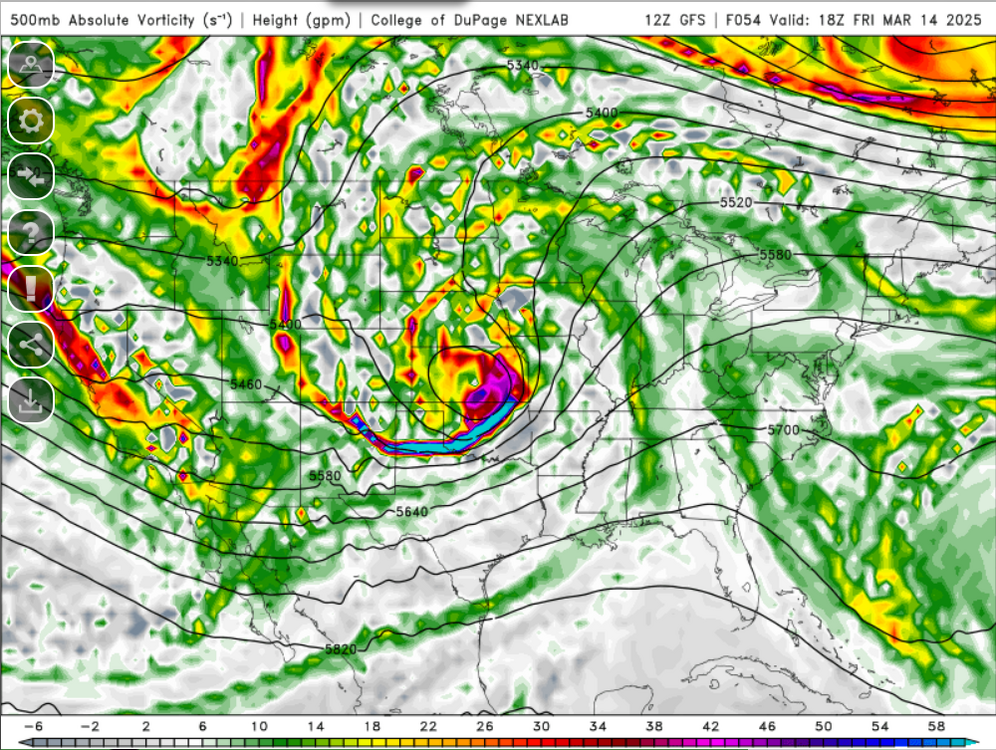
I really can't get over this shortwave. That is some environment there...I bet there is an upgrade to a massive moderate risk. Probably a narrow corridor too for an intense tornado or two.
-
That is one negative about anomalous early season warmth...it makes days like today (which are fantastic) seem a bit "worse" than they really should be. I mean if we had today after a stretch of 20's or 30's...this would be superb but having this after multiple days of 60's seems like a step back
-
Hey @dendrite that temu clown is back...but thankfully this time I don't need a language translator to see how badly I'd get scammed
-
But I also think this goes to show how important the Fall can be, particularly late Fall in "setting the stage". Obviously things can drastically change mid-season (winter) but that is usually the product of something of high magnitude (major SSW, PV split, constant Rossby wave breaking, etc.). This winter should be a great case study. I mean we already have a general idea of why it didn't produce but after the fact...the signs were most likely there all along that these "good looks" weren't going to produce. But this is how we better ourselves and increase forecasting capabilities...look at what went wrong, identifying those flags and then comparing to the data set and differentiating between good years versus no good years.
-
Agreed with that 100%
-
51 days until May 1 35 days until the 384th hour of the GFS goes to May 1
-
The one thing that prevented more in the way of extremely cold Arctic temperatures was...the lack of extreme cold within the Arctic region. Hell, look at the central states during February...that was pretty low standard to the typical true Arctic airmasses they get.
-
If not for the later timing, we probably would eventually see a marginal risk here Sunday...BOOOOOOOO
-
That is an intriguing severe weather setup Friday. Only real negative is its still a bit too early for those juicy dews but the southern flank of that risk area...southern Arkansas into western TN could be prime for discrete supercells and strong tornadoes. That is going to be one major widespread damaging wind event though
-
GFS has some rogue robust shortwave energy. Euro has it to some degree, though not as intense. I do think we could see some rain/higher elevation snow showers develop late afternoon/evening.
-
Must be above 90 and dews above 70 for me to consider shorts. It gets cool at night, even in summer…unless it’s tropical and lows stay in the upper 60’s or 70’s
-
I've always wondered too, is it at all possible that increasing model resolution may actually have some negative impact on model performance moving forward in-time? I could see where I am wrong in this because the equations (deltas in change in wind/direction over time, temperature, pressure, density, etc/) usually only deal with certain scales and I'm sure there are equations built in to perhaps assist with this but I have to wonder if sometimes the increased resolution adds some sort of negative feedback within the extended range.
-
Well said. And now that we are moving into Spring we're going to see the hype train transition over the the severe track. Obviously it will go unnoticed with our region but over the next 2-3 months it will be nothing but Supercell Composite/Significant Tornado Parameter charts circulating all over social media and hyping every trough ejecting into the southern Plains as the next 5/3/99 or April 2011. Back to the research side of things, if I get time this summer I really want to dig into the last 3-4 winters and do a more in-depth comparison to previous winters, winters which produced and winters which didn't. I know this research exists out there and there are people who are already well advanced in this topic already, but what I really want to focus on are pattern transitions and pattern evolutions. This is at least the 3rd winter in a row where we've been tantalized by "good looks" in the extended range with little return. Yes, good looks doesn't guarantee anything but that answer just doesn't suffice with me. We get too caught up in just static plots...we can look at monthly 500mb height anomalies in the Arctic domain for some of the most negative NAO January's on record and make some conclusions...but the reality is, its not the averaged pattern or the averaged anomalies which count, its how you transitioned to that point. If you look at the last several years (maybe not so much this year) but all these "good looks" that developed, those favorable patterns occurred on the back end of cutters or back end of weather systems moving off the East Coast and then its a quick transition to not so favorable patterns ahead of the next system...that isn't going to cut it. I know there are statistics which correlate teleconnection phases, ENSO, etc. to temperatures, precipitation, and snow but none of those correlations are strikingly high. I have to think through the means of additional research and critical thinking, we can probably increase forecasting accuracy, even if there is little improvement in model skill in the medium range.
-
With alot of the recent changes this may not be as feasible anymore, however, I wonder if there was alot of work/research going into the GFS in the extended range and what is causing it to struggle mightily with the northern stream and why there is a tendency towards the evolution of snow storms within the Northeast. I'm sure there had to be because this is how upgrades are performed but this tendency is often enough there must be something within its physics...but this goes welllll beyond the ability of my brain comprehension. Anyways...its not good. Its not good for the field and its not good for those involved in forecasting professionally. There were the last storm we got and someone I work with said, "Weather is always changing, look at this storm we just got. My wife a few weeks ago saw something where we we were supposed to get 30" and look, we got like 8". I know exactly what he was talking about...it was the one storm where the asshole snow maps were getting tossed around all over because they were showing 20-30 inches over a huge chunk of the region. But there is just so much hype generated in the 6-10+ day time frame it's absolutely ridiculous. It really drives me to the point to where sometimes this isn't fun anymore, there is no more science its just pure hyped garbage. Just like when you read content posted...and from meteorologists, "This isn't a forecast and I'm not saying this is happening but a possible solution" captioned above something clearly meant to drive hype. WHAT POINT IS THERE POSTING SOMETHING LIKE THAT? There is none outside of generating clicks, likes, and followers...that is it. But the field is getting watered down by pure senseless garbage.
-
The one I was interested in for like 20 minutes and thought "we had a chance I'll take this though...its time to move on from winter
-
animated.mov


