weatherwiz
-
Posts
81,150 -
Joined
-
Last visited
Content Type
Profiles
Blogs
Forums
American Weather
Media Demo
Store
Gallery
Everything posted by weatherwiz
-
Friday could be pretty decent for the Adirondacks. Could get smoked pretty good actually.
-
Maybe the problem is just where it is being dumped. I know Ray has mentioned this several times, but we haven't really had any patterns favoring dumping the source region cold directly into our region. The dumps have been central Plains, upper-Midwest, and then those airmasses are moderating quickly as the move our way. Also, even this winter was seasonably cold here (I would at least term it that way), it seemed there was just a lack of that bitterly Arctic cold on this side of the hemisphere. There was that one period in mid-February where the central states got it. Ultimately though, from a research perspective, we may have to fine tune expectations or re-define the sensible aspect of weather as a result from the combination of teleconnections. What probably was a strong correlation in the 1970's and 1980's...might not be as strong anymore. And this could be from a variety of different reasons, including just from building the database itself....adding more scenarios to the picture.
-
I mean look at the backside of the past few systems that ejected into the Plains and lifted northeast along with the one for mid-week. For such strong and rapidly deepening low pressure systems, the cold spilling in on the backside seems lackluster. Its cold air wrapping into the system...as soon as these systems are ejecting out of the region, the warm right back up. It's not like these systems are bringing days and prolonged stretches of BN temperatures within the central states.
-
And when looking at any "cold shots" in the extended they are going to end up moderating as we get closer. I don't think there is much to suggest its a colder look or we're going to enter a BN regime. The teleconnections can say what they want but there is one thing we're lacking...a colder base across Canada. Just seasonably chilly, at best behind systems. However, if we get some wonky stuff where we're stuck in an onshore misery with extensive clouds and drizzle...that is a different story.
-
Any cold or below-average periods will likely be brief and the result of strong fronts moving through as opposed to any significant changes in the pattern. There will be some crap days for sure but the overall but as long as we continue this theme of rapidly deepening lows which eject into the central Plains and lift northeast, the warmth will outweigh the cold.
-
A precursor to the derecho we’ll see in a few months
-
Maybe more of an inversion down that way?
-
Some big gusts here…very loud.
-
just insane. I always get a kick out of the video out there of two people watching it come towards them and saying "it isn't that big" But this is just crazy to have such a visual in this region.
-
Can’t believe 2018 was already 7 years ago and 2011 14 years ago
-
Can’t wait until these are 30F higher
-
I’m sure the higher elevations will get another accumulating snow event before all said and done
-
Holy shit

-
I don't know how people can sit on ice. I would be EXTREMELY nervous that I would fall in. If I wanted my butt to be cold I'll just sit inside a walk-in freezer.
-
This is more like it
-
Curious to see how well that verifies. We all know there is a tendency this time of year for those cold shots to be overstated and this one may fit that mold. However, that isn't a good enough reason to justify this case but when looking at this you can see why it probably is overstated. First off, these are some intense cyclones undergoing rapid cyclogenesis crossing the Plains so they are drawing down some chilly temperatures on the backside. Hell, there could be a decent swath of heavy snow on the backside of this from South Dakota through southern Minnesota and even within the Ohio Valley they could get snow showers Wednesday night. Anyways, for us, these systems are also occluding extremely quickly and tracking well to our northwest...its difficult seeing any anomalously cold llvl airmasses truly advect into our area. But maybe the BN temps are more related to some local influences with onshore flow from the cuttoff in the ATL?
-
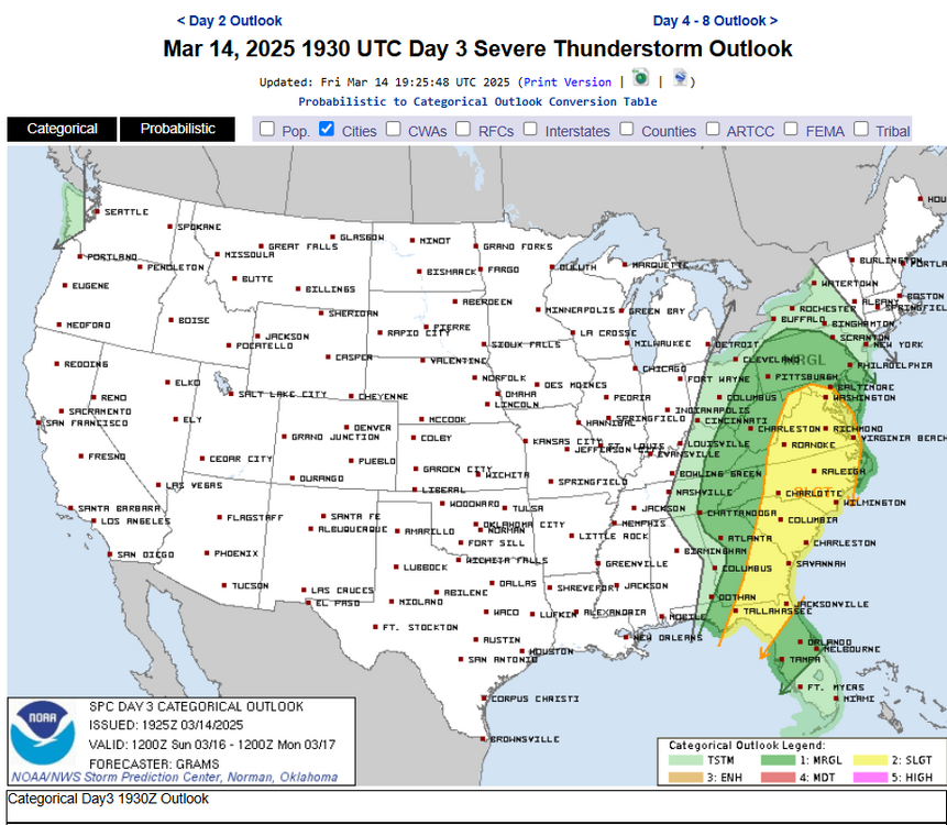
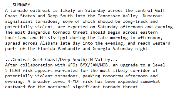
About as intense of wording as you'll see with this much lead time. Perhaps the scariest part of these next two days is great significant tornado is evening into overnight period when you get the additional ramp up of the LLJ. Sometimes you'll end up seeing potential lessened because of storm mode (quickly becoming linear) but the southern extent of the whole risk area is really primed for numerous discrete supercells based on wind profiles.
-
Thought we may see a high risk
-
Could be quite warm indeed just ahead of the front.
-
Tomorrow could be very bad, especially if the storm mode stays discrete for a bit. Eventually everything will grow upscale into a QLCS but that southern area there may actually be predominately discrete cells. I still think we could see a high risk
-
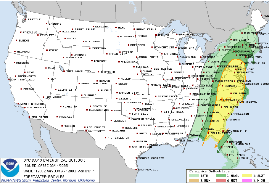
TBH I don't even know if anyone in SNE gets any thunder. I'm pretty shocked to see the marginal so far east...thought the cutoff would be well back to like PA/NJ border. Eventually we'll see it cut back.
-
Going to be some nasty supercells out in eastern Missouri today...hauling ass too.
-
Did not think we'd see (or even need) a Marginal Risk in our area but alas we have it so just enjoy it! Put the snowblowers away, snow shovels, snow map, snow boards...its a new season. Lets get things cooking before May
-
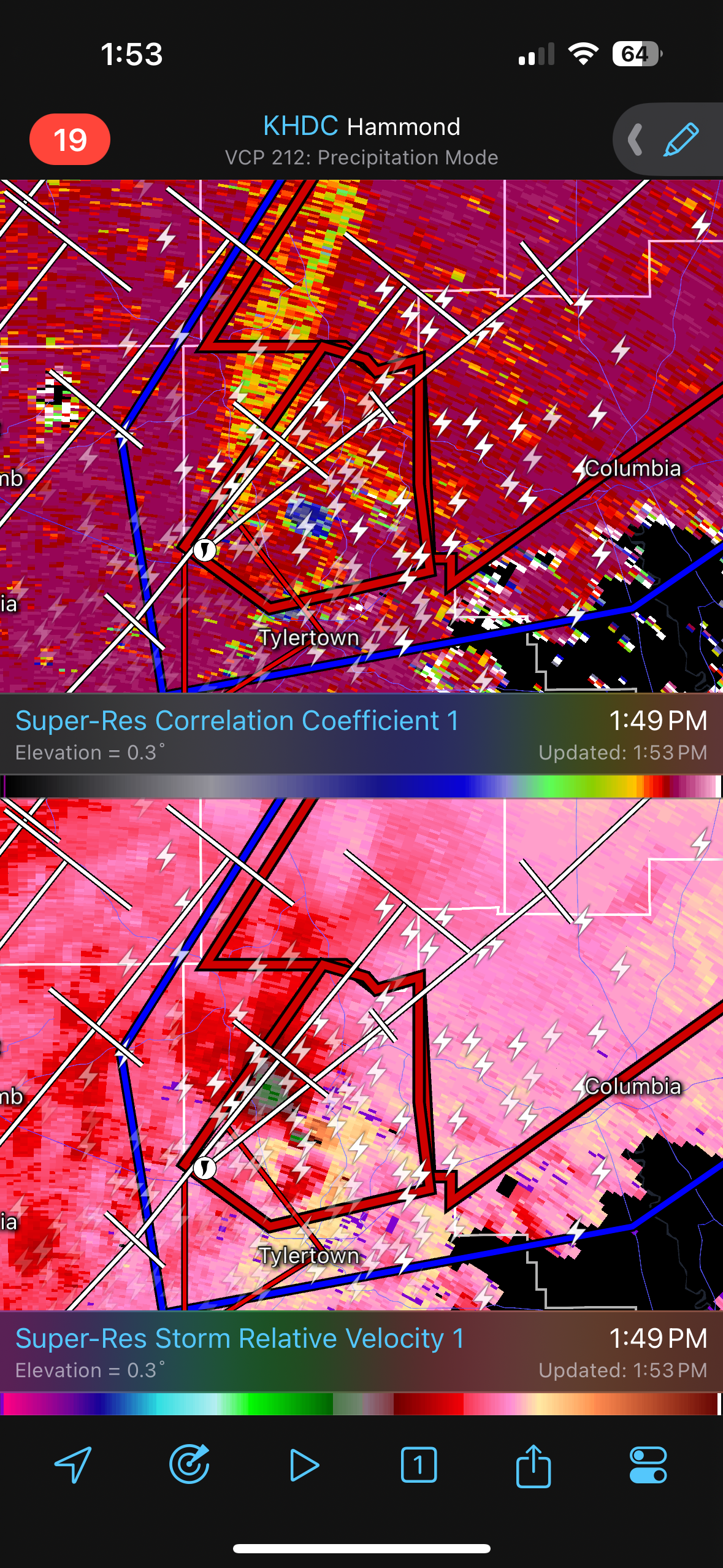
It's going to be an overnight event mostly...Saturday will be during the day and I'll be following along. I mostly use spc mesoanalysis https://www.spc.noaa.gov/exper/mesoanalysis/ and watch satellite and use Radarscope/Gr lvl 2. I like the gr lvl 2 to get some 3D views of the storm structure and see how high debris is being lofted. But I don't really follow any streams or anything.
-
We may see southwest Connecticut kiss a marginal risk Sunday