weatherwiz
-
Posts
79,817 -
Joined
-
Last visited
Content Type
Profiles
Blogs
Forums
American Weather
Media Demo
Store
Gallery
Everything posted by weatherwiz
-
Some interesting differences on the NAM versus GFS and one of the noteworthy differences is temperatures. At 0z Thursday the NAM is mid-to-upper 50's while the GFS is upper 50's to lower 60's. This may not seem like much but that delta could be a big difference in what is realized in wind potential. I would side with the GFS on this and if you put those temps with the NAM's evolution that is a major wind event for most.
-
Holy shit you're right...I see that at 7:00. That would probably be just before the main line would be approaching BOS too. Just checked the 3km and it has a pretty solid line. You may actually see the line strengthen as it moves west-to-east across the region with the enhanced upper support.
-
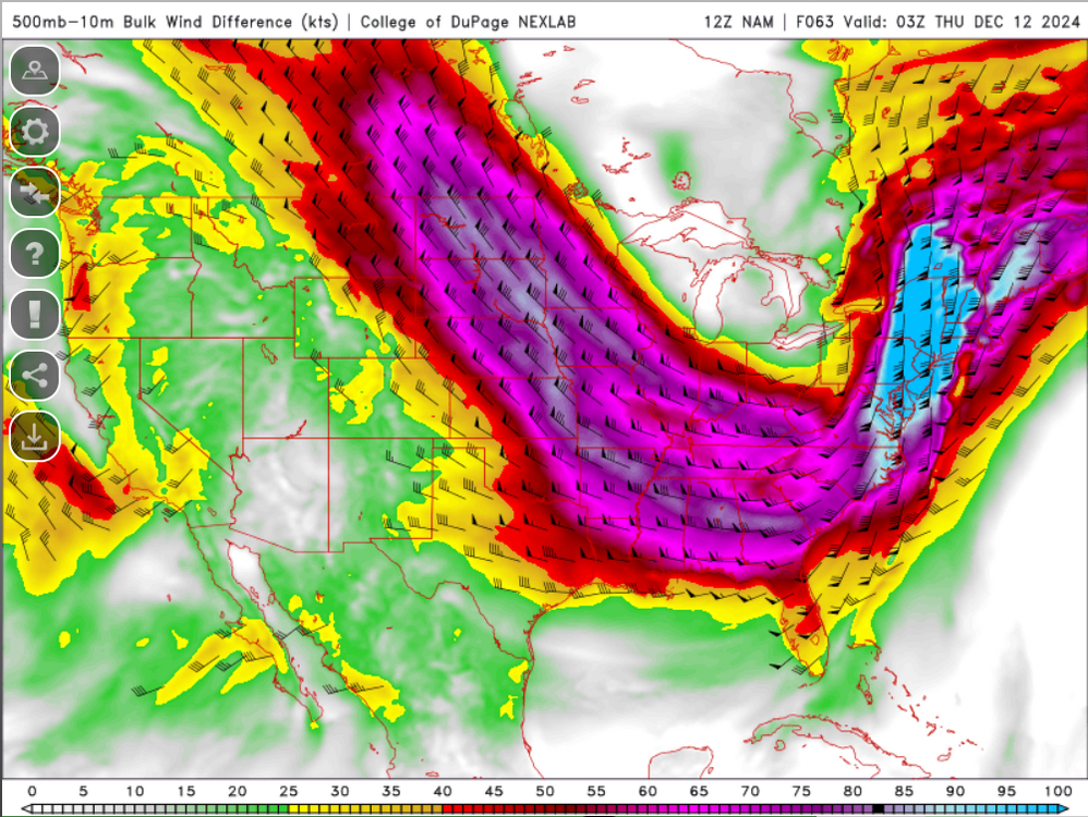
Just checked 6z GFS for bufkit at BOS...that is pretty wild at 9:00 PM Wednesday night. Though if you toggle the Momentum Xfer from 10 to 1 you can see that it is probably a bit overmixed. My early thoughts with this is we'll see some decent sustained winds across the region but if you're going to want gusts above 50 mph you're going to need the assistance of convection. Without convection the gusts may be difficult to come by (and for what you said...showery stuff stabilizing things). And good note about the wind with lines in these setups...important to understand the strongest winds occur just out ahead of the line and just prior to the arrival of the heavy rains
-
Going to be one heck of a forced line with wind damage.
-

December 2024 - Best look to an early December pattern in many a year!
weatherwiz replied to FXWX's topic in New England
yeah if we see a stronger and deepening low just to our west its game on for some wind wind inland. At least right now though, this could be a huge wind issue towards the coast of Connecticut and eastern New England. IIRC, for coastal areas the strongest winds tend to be just a bit inland away from the water. Though an inversion may not be a huge issue in this one with temps/dews around 60. -
December 2024 - Best look to an early December pattern in many a year!
weatherwiz replied to FXWX's topic in New England
SPC going to have to expand the general thunder line farther north...may even see a marginal risk added. Could see some convectively driven damaging wind gusts potential and even a low end risk for a tornado just to our southwest -
December 2024 - Best look to an early December pattern in many a year!
weatherwiz replied to FXWX's topic in New England
Sounding on the CAPE. That's serious stuff just above the ground Connecticut shoreline just a bit inland -
SNE GTG Banter Thread: Funky Murphy's 1pm 12/14
weatherwiz replied to 40/70 Benchmark's topic in New England
We can make a new thread for January and propose dates...maybe even add in some February too. The earlier the better so people can check schedules, etc. -
December 2024 - Best look to an early December pattern in many a year!
weatherwiz replied to FXWX's topic in New England
Confidence in mid-to-late month has to be extremely low right now. -
December 2024 - Best look to an early December pattern in many a year!
weatherwiz replied to FXWX's topic in New England
That was probably dumb of me yesterday to think there was a shot to see things trend not as warm on the GFS. Anyways, we know inversions can tend to screw us and limit wind potential but if we see sfc temps and dews push 60 and get convection into play...an inversion won't be much of a concern. We'll see how far west and how far inland the wind potential gets but this could be a pretty big deal for eastern sections, especially towards the Cape and coastal Maine. Could be something a little more than our typical cool season wind events. -
December 2024 - Best look to an early December pattern in many a year!
weatherwiz replied to FXWX's topic in New England
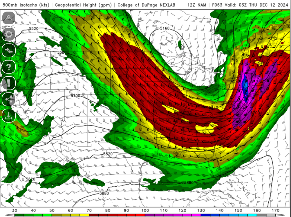
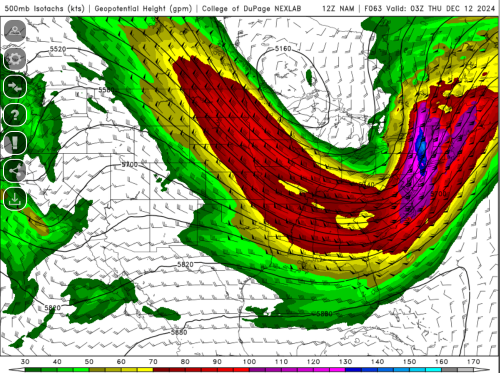
GFS even with a touch of sfc instability (even the NAM). We see dews push 60 and this will be wild. These bulk shear values are insane...nearly 110 knots. Lets get a forced line going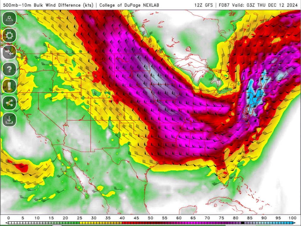
-
December 2024 - Best look to an early December pattern in many a year!
weatherwiz replied to FXWX's topic in New England
I guess I just wouldn't be surprised if we see a bit of a trend towards the warmth not getting as far inland. But I suppose there won't be much to stop warmth from flooding in just south of the warm front. -
December 2024 - Best look to an early December pattern in many a year!
weatherwiz replied to FXWX's topic in New England
I would think the warm front would struggle to propel northwards through the region. The SLP track is a bit too east and also noting the multiple waves developing along it. Probably end up seeing a funky looking sfc warm front. -
December 2024 - Best look to an early December pattern in many a year!
weatherwiz replied to FXWX's topic in New England
Part of me thinks the GFS is a bit too aggressive with the warmth into SNE Wednesday. Coastal areas yes but I question how far north we'll see 50's surge. -
SNE GTG Banter Thread: Funky Murphy's 1pm 12/14
weatherwiz replied to 40/70 Benchmark's topic in New England
I'm fine with that. I would like to get to see as many people as possible. Clarke's would be out for me but we can re-tackle Funky's after the New Year. -
You don't see it too much around here but sometimes its a riot seeing what MOS/NBM has for some of the midwestern cities. You can sometimes see like a 15-20F difference in the forecast high or sometimes even the low. Not of course you would divulge into the details and should be able to develop a sense of what to expect but sometimes that along can't be enough if you don't understand the local climate.
-
I know at the end of the day when it comes to forecasting temperatures this does require a bit of effort if you want to be really accurrate and get within a degree or two. I know when I used to do the wxchallenge I used to spend like 30 minutes for the high/low temp Anyways, MOS/NBM have been atrocious the last month...not just here but across a good part of the country. I get they have limitations with specific patterns and such but these products can be downright embarrassing. Forecasting too cold at night when it doesn't get that cold, then when they forecast on the warmer side it ends up much colder. They will underperform on highs plenty of times and then rare times they underperform on highs when it didn't seem like that would be the case. It sucks when you have to solely use these products for temperatures because they're awful really.
-
December 2024 - Best look to an early December pattern in many a year!
weatherwiz replied to FXWX's topic in New England
I buy northern New England and the higher terrain of Mass coming out of mid-week with plowable accumulations. Have to watch for some powerful winds northeast coast of Maine too. -
December 2024 - Best look to an early December pattern in many a year!
weatherwiz replied to FXWX's topic in New England
This is true...hopefully something that can work to our benefit once we get a bit deeper in the month and towards January. -
SNE GTG Banter Thread: Funky Murphy's 1pm 12/14
weatherwiz replied to 40/70 Benchmark's topic in New England
I would favor something more in January or even February. Its after the holiday...still may be tough for kids in winter sports (I know basketball can run into March). -
December 2024 - Best look to an early December pattern in many a year!
weatherwiz replied to FXWX's topic in New England
It seems like this has been a crazy theme the last several winters. Even when we are in a good pattern, we can't seem to get something to work and when we do get storms the trough axis develops just too far west and we're getting flow blown warm sector. Is it possible the warm waters are having a big influence in this? Part of me is curious on this but on the other hand, it's not like we see fronts and boundary's struggle to get off the coast but it seems that now consistently these type of setups cyclogenesis is just way too far west for us. Doesn't even seem to matter what the overall regime is, the evolution seems to gravitate towards this. -
SNE GTG Banter Thread: Funky Murphy's 1pm 12/14
weatherwiz replied to 40/70 Benchmark's topic in New England
I plan on going but if there isn't enough of a turnout I'm fine with another date too. -
-
Definitely going to give this a read, thank you! And that was something I was going to mention too...don't current NWP models already have some degree of AI integrated into them? But looks and sounds like that will be established in the paper.
-
Agree, poorly worded by me. I am definitely interested in reading literature on this and I am certainly open to having a completely different view on this. What really irks me though (and not just with AI) is these watered down articles and and all these claims made just to draw people in, especially from companies and organizations who profit on marketing stuff...you can make anything sound good and like the best thing ever and sell it to the average Joe.