

calculus1
-
Posts
5,305 -
Joined
-
Last visited
Content Type
Profiles
Blogs
Forums
American Weather
Media Demo
Store
Gallery
Everything posted by calculus1
-
I think something is wonky. I don’t think IP or ZR are even options with this storm. Currently at my high temp of the day of 36.3 F.
-

The “I bring the mojo” Jan 30-Feb 1 potential winter storm
calculus1 replied to lilj4425's topic in Southeastern States
Is Skip Waters the same as @beanskip? He used to post quite regularly on this board. -
The “I bring the mojo” Jan 30-Feb 1 potential winter storm
calculus1 replied to lilj4425's topic in Southeastern States
I really like the fact that this weekend is compared to the 12/26/2010 analog. If this storm develops anything like that Christmas storm, most all of NC will be most happy. -
It appears 7.8 will be my low this morning. Actually, a bit warmer than I had expected.
-
I have not seen him on this forum in a long time. It's been ten years or more since he last posted, if I recall correctly. He had his own paywall website for a while, and a public FB page, but I don't think those exist anymore either. Sorry.
-
I ended up barely making it above freezing at 1:34 this afternoon, when we hit 32.1 F IMBY. We have since fallen back down to 26.8 F, at 4:40 PM, under full sun. This is a cold day by Hickory standards. This sleet has staying power, as does the freezing rain. Anything that was shaded from full sun, has not had any melt today. My driveway, is still a solid 1.5+ inches thick of sleet concrete. Schools are already canceled again tomorrow, and Wednesday is looking like a remote learning day.
-
Perhaps Robert? @wxsouth
-
I think it has a decent chance to meander NW. We have five or so days for that happen. Nothing is written in stone, yet.
-
"Prince Euro." I see what you did there. LOL I continue to regress in temperature. Down to 31.0 F.
-
I made it up to exactly 32.0 F at 10:53 AM, but I have since begun to fall backwards in temperature, which is incredibly odd for this time of day. Now back down to 31.4 F. Regardless, the sun is doing its work on the minimal ice on the trees, and I am sure it is sublimating some of the ice on the ground, but these two inches of sleet may have substantial staying power.
-
2025-2026 Fall/Winter Mountain Thread
calculus1 replied to Buckethead's topic in Southeastern States
I’m gonna go A-. This storm reminded me of those winters as a kid. The sleet was fantastic! The CAD was amazing! Still in the 20s here. Hardly any glaze, just enough to be pretty, so I never lost power. Sledding was great. Schools will be closed Monday (and probably Tuesday and Wednesday here in Catawba County). Roads are straight up glaciers. This whole next week will be abnormally cold. Loved it! -
Finished with 2 inches of sleet and 5-inch drifts on the front walk where two separate roof sections drain. .
-
This is awesome! I shared a short video in the general obs thread. We are still at 24.6 with IP+. So cool!
-
Southern Crippler - Get well soon Jimbo Storm Obs
calculus1 replied to BooneWX's topic in Southeastern States
Just mega sleetfest here in NE Hickory right now. Crazy awesome! Sleetfest.mp4 -
The line has arrived. All sleet! Heavy sleet!
-
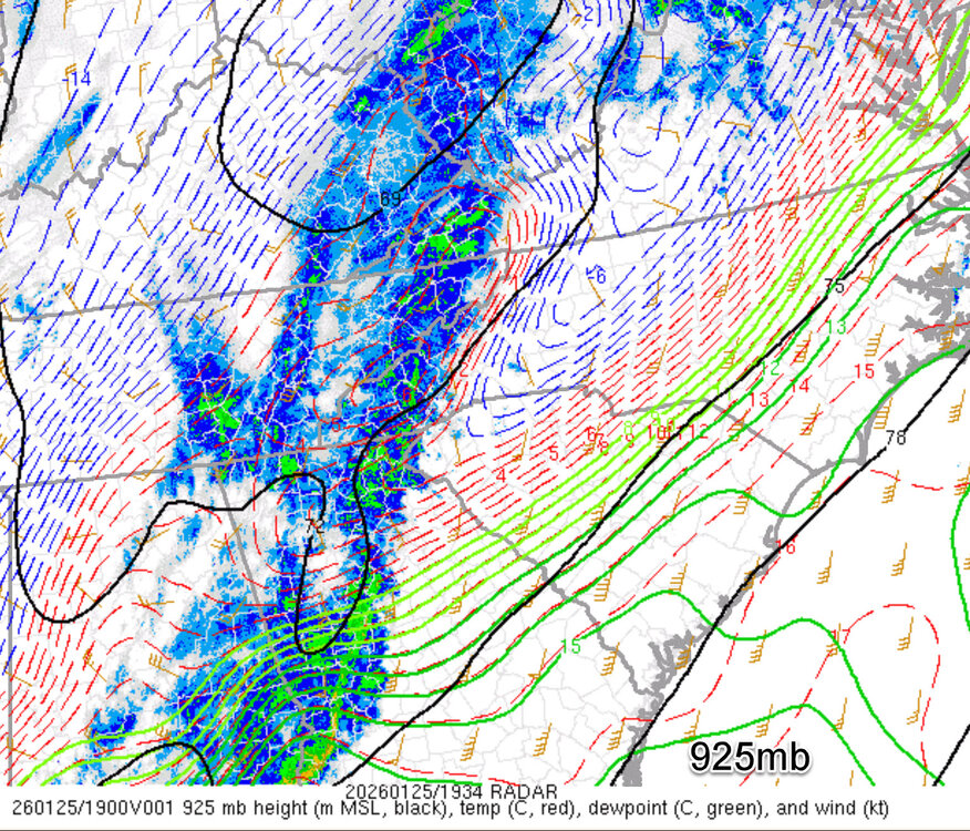
Look at the sharpness on this CAD. Maybe sleet rather than ZR where those 925s are coldest?
-
25.2/22 here. Interested to see whether this is insane sleet or freezing rain...
-
24.6/22 right now. Crazy cool for almost 1:30 in the afternoon.
-
Finally got out to measure and sled. 1.5+ inches of accumulation. Still sleeting. 21 F. .
-
Very heavy sleet right now. Heaviest I have seen so far at any point in this storm. Still, hardly any glaze to speak of in the trees.
-
Thanks, man. Yes, it is nice to wake up to a wintry scene (and still have power). It’s been a while. It’s not the big snow we wanted, but it is still a wonderful scene. .
-
Outside this morning. Just beautiful!
-
2025-2026 Fall/Winter Mountain Thread
calculus1 replied to Buckethead's topic in Southeastern States
Wow! That’s quite a bit of ice for you, @Met1985 . Very atypical, I would imagine. . -
Very tiny sleet pellets. Very cold. Very little glaze. Awesome! .
-
Southern Crippler - Get well soon Jimbo Storm Obs
calculus1 replied to BooneWX's topic in Southeastern States
16/15 Everything covered in snow/sleet mix. Mainly sleet, I believe, but it did slow at several points last night. The trees are not drooping at all. So, minimal glaze here, thankfully.


