CT Rain
-
Posts
26,264 -
Joined
-
Last visited
Content Type
Profiles
Blogs
Forums
American Weather
Media Demo
Store
Gallery
Everything posted by CT Rain
-
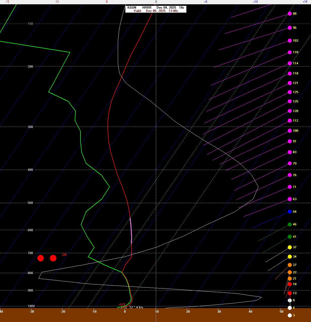
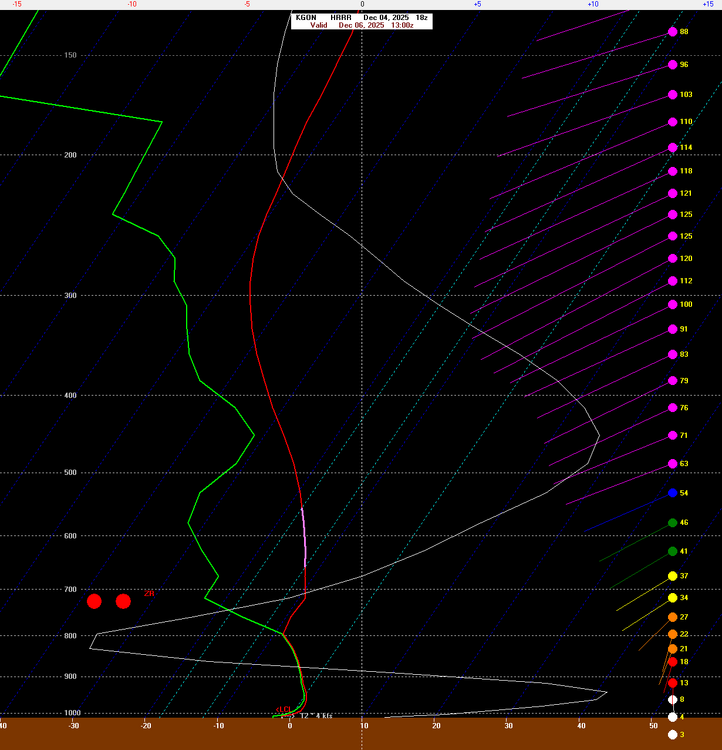
Could be some FZDZ especially at the coast Saturday AM. Worth watching for some sneaky issues.
-
Probably some boundary layer issues south coast too.
-
We take.
-
That's awesome. Glad to see the winter starting with a bang for you guys.
-
I love how Jay is reporting 38-55" in the last 7 days. Quite a range!
-

November 2025 general discussions and probable topic derailings ...
CT Rain replied to Typhoon Tip's topic in New England
Yeah it's def been running warm. -
A Carrington event right over Kevin.
-
November 2025 general discussions and probable topic derailings ...
CT Rain replied to Typhoon Tip's topic in New England
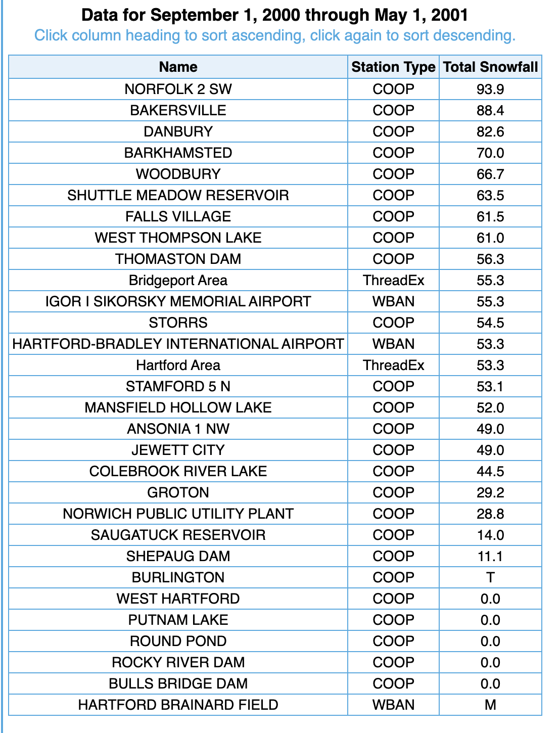
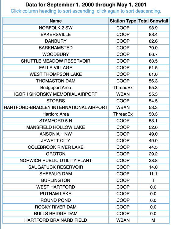
It is missing a lot - I wouldn't use it. Shuttle Meadow Res in Southington is a decent proxy I think. -
November 2025 general discussions and probable topic derailings ...
CT Rain replied to Typhoon Tip's topic in New England
-
November 2025 general discussions and probable topic derailings ...
CT Rain replied to Typhoon Tip's topic in New England
Soundings looked decent for some scattered snow showers. We'll take what we can get. -
November 2025 general discussions and probable topic derailings ...
CT Rain replied to Typhoon Tip's topic in New England
The data is pretty clear. We're warming and it's mainly us. There's really not much a question here. If you want to have a debate on how that warming manifests itself or what we should do about it (if anything) those are completely reasonable questions to ask. -
Spooky Season (October Disco Thread)
CT Rain replied to Prismshine Productions's topic in New England
What model is this? -
Spooky Season (October Disco Thread)
CT Rain replied to Prismshine Productions's topic in New England
She's gone. -
Spooky Season (October Disco Thread)
CT Rain replied to Prismshine Productions's topic in New England
You're ridiculous -
2 days late... but not denied?
-
Spooky Season (October Disco Thread)
CT Rain replied to Prismshine Productions's topic in New England
Euro drops like 20" of rain in DC lol -
GFS is really nasty for the Jersey Shore. Doesn't look like a whole lot around here besides rain and some wind.
-
Where do you find these graphics? lol
-
The GFS is really nasty. That's quite the damaging wind signature especially south coast.
-
Spooky Season (October Disco Thread)
CT Rain replied to Prismshine Productions's topic in New England
I haven't looked this morning but yesterday the GFS BUFKIT soundings had like 60 knots at the top of the mixed layer for IJD/HFD/etc -
Spooky Season (October Disco Thread)
CT Rain replied to Prismshine Productions's topic in New England
The GGEM has come much farther north after being a southern outlier. The GFS is a pretty significant damaging wind event so worth watching. -
Really nice looking hail setup
-
Congrats Litchfield County
-
Decent looking shear.
-
I admire your weenieness!