CT Rain
-
Posts
26,264 -
Joined
-
Last visited
Content Type
Profiles
Blogs
Forums
American Weather
Media Demo
Store
Gallery
Everything posted by CT Rain
-
And it's normally right
-
NAM is sort of a torch lol
-

January 2026 regional war/obs/disco thread
CT Rain replied to Baroclinic Zone's topic in New England
Just uploaded a new youtube video after some of the 12z guidance. You may find it a bit interesting - or not lol https://www.youtube.com/watch?v=tb_0phGpeCs -
Love kissing the DGZ on the ground.
-
It's a real mess. PHI put out a map and then annotated on it to expect less due to mixing. Like huh?
-
The NWS forecasts have sort of been a mess. Watch text not matching maps, maps changing quickly, etc. Seems like it's NBM gone awry.
-
Woody slots around midnight lol
-
That's a deep DGZ lol
-
January 2026 regional war/obs/disco thread
CT Rain replied to Baroclinic Zone's topic in New England
What's best about this is we'd get Scott to stop whining! -
January 2026 regional war/obs/disco thread
CT Rain replied to Baroclinic Zone's topic in New England
Pretty good trends overnight IMO. Seems like potential for a decent event Sunday/Monday. Don't think the upper end is too high here but could be a nice moderate kinda event? -
January 2026 regional war/obs/disco thread
CT Rain replied to Baroclinic Zone's topic in New England
-
Yeah it'll be a blast. Seems like Aspen is in a bit better shape than some of the other resorts in CO. Hoping for a surprise with one of the systems moving off the Pacific this week.
-
Killington was surprisingly good Thursday/Friday. Some ice and definitely fast but they recovered nicely from Monday's ice. Lift lines were fine too. Heading to Aspen in a week... ugh. What a disaster out in the Rockies this year.
-
26th-27th event, coming at us like a wounded duck.
CT Rain replied to Go Kart Mozart's topic in New England
I can't speak for other markets but at least in Hartford-New Haven I think the average TV forecast is typically more conservative than the NWS and also more frequently correct. -
26th-27th event, coming at us like a wounded duck.
CT Rain replied to Go Kart Mozart's topic in New England
That's true.. however their snow forecasts are almost always far more bullish than the people doing it for "ratings, page views, clicks, or advertising revenue." Not sure how to square that circle. -
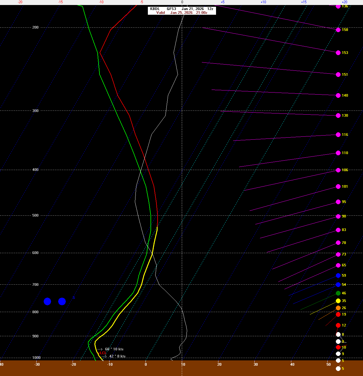
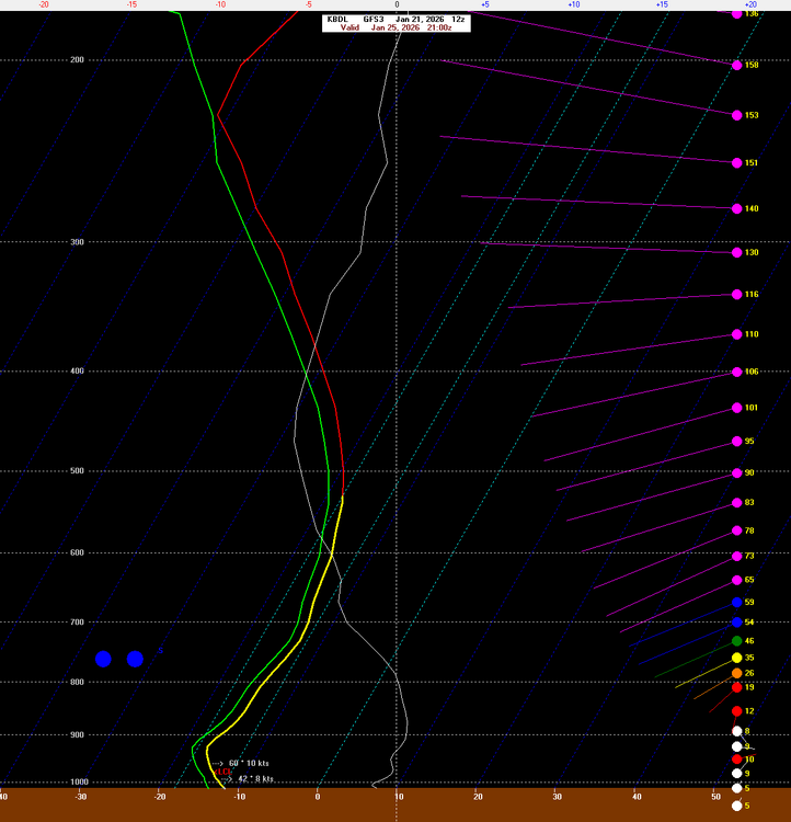
This system looks like crap at 500mb but we still manage nice lift thanks to warm advection along that baroclinic zone. Probably turns out being a more narrow band of good stuff than what's currently modeled.
-
-
If it's not in the model blend it's probably not making it into the forecast.
-
Meh on the GFS. What a surprise. Just posted this video on the pattern for Christmas week. https://youtu.be/zPngHf9xvyY
-
The models yesterday didn't really have this thin layer of moisture at 850.
-
That video was wild. I'm hopeful after Friday's torch we can start building up again Christmas Week. I'm heading to Killington for New Years so fingers crossed!
-
PF gets a good snowstorm on Boxing Day too!
-
Shut the blinds through Christmas. Ugh.
-
December 14th - Snow showers or Plowable snow?
CT Rain replied to Sey-Mour Snow's topic in New England
Nope. New Haven lol -
December 14th - Snow showers or Plowable snow?
CT Rain replied to Sey-Mour Snow's topic in New England
Thank you! Yeah I normally do them at work in a studio but just fired up the laptop today in the dining room lol