CT Rain
-
Posts
26,264 -
Joined
-
Last visited
Content Type
Profiles
Blogs
Forums
American Weather
Media Demo
Store
Gallery
Everything posted by CT Rain
-

Friday February 6 FROPA / WINDEX small event
CT Rain replied to HoarfrostHubb's topic in New England
Another Kuchera -
You're so dramatic lol
-
Agree
-
Possible coastal storm centered on Feb 1 2026.
CT Rain replied to Typhoon Tip's topic in New England
yeah those time lagged members are skewing it. But good luck with Kevin's 6-10 EOR. -
Possible coastal storm centered on Feb 1 2026.
CT Rain replied to Typhoon Tip's topic in New England
-
Possible coastal storm centered on Feb 1 2026.
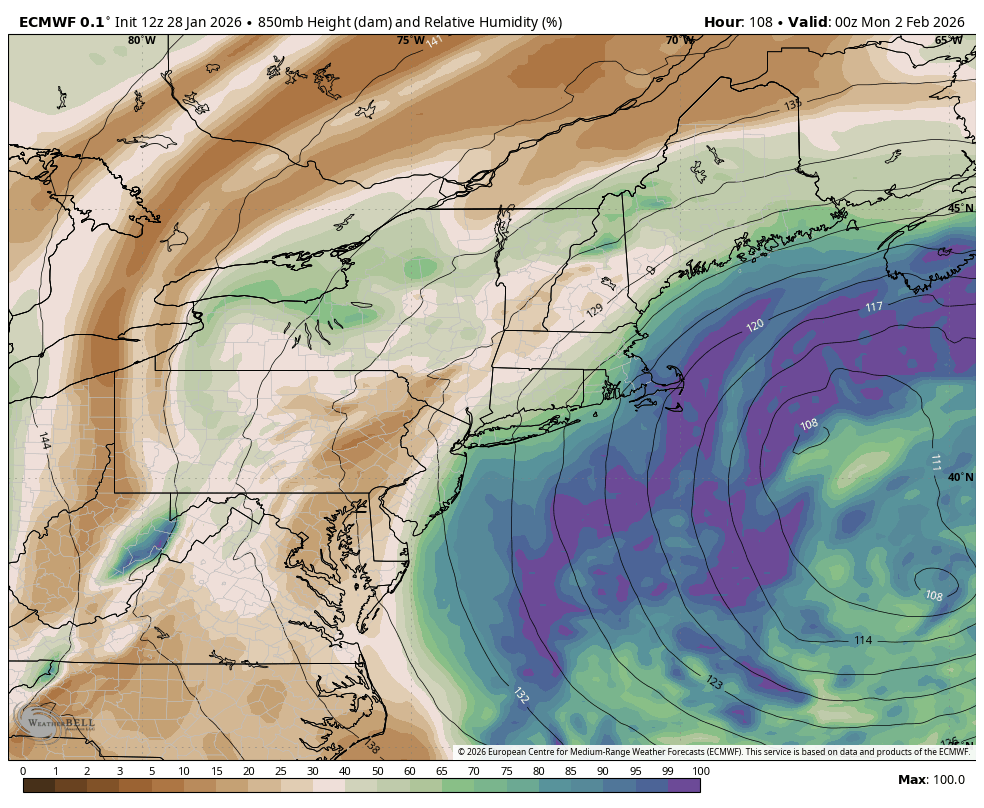
CT Rain replied to Typhoon Tip's topic in New England
Not pictured is the dry air at 850mb.
-
Possible coastal storm centered on Feb 1 2026.
CT Rain replied to Typhoon Tip's topic in New England
...for ACK. -
Possible coastal storm centered on Feb 1 2026.
CT Rain replied to Typhoon Tip's topic in New England
Yeah just not feeling this one. The Cape could still get hit hard though. -
Possible coastal storm centered on Feb 1 2026.
CT Rain replied to Typhoon Tip's topic in New England
Would be great for any model other than the GFS/GEFS to get on board. -
Possible coastal storm centered on Feb 1 2026.
CT Rain replied to Typhoon Tip's topic in New England
How may will perish? -
Possible coastal storm centered on Feb 1 2026.
CT Rain replied to Typhoon Tip's topic in New England
Jesus -
17.0" here
-
Yikes. Already up to you
-
50/50 NAM/Euro blend probably makes sense right now.
-
You're not angering anyone you're just taking the time to look at output that might as well been created by Kevin after 3 zimas and a box of colored pencils. You do you though!
-
Yeah Euro cooled a bit but no change in QPF. We take.
-
Probably drop for southern 1/3 to 8-12 and keep 12-18 inland.
-
8" for Kevin and 18" for you? Yikes.
-
From 6z to 12z the NAM is certainly juicier with QPF but no real change in the sleet penetration. So overall a plus I guess.
-
It's worse.
-
Nam is perilously close to a ton of sleet for most of CT/RI/SE Mass.
-
I was thinking that too. Seems possible.
-
It's too dependent on surface temps when once you're below 31 or 32F they don't make any difference at all. The key is to figure out how efficiently snowflakes are produced (maximized around -15C) and the favored crystal type which impacts the density of the snowfall (ratio). For any real skill you have to look at where lift is maximized and at what temperature and also the depth of the DGZ (-12c to -18c). Kuchera would do OK if you're right around 32F because it would skew numbers down in that case not due to bad snow growth but due to melting/compacting.
-
I have 10-18" for the state. Just post the straight QPF and adjust as necessary in your head based on expected ratio. They're just not good.
-
Can we stop with the stupid Kuchera maps?