CT Rain
-
Posts
26,253 -
Joined
-
Last visited
Content Type
Profiles
Blogs
Forums
American Weather
Media Demo
Store
Gallery
Everything posted by CT Rain
-
Has anyone checked in on Stein?
-
Thankfully Twitter is not real life!
-
Here's the CT stuff. It covers close to 1/3 of the state. https://yalecovidwastewater.com/reports
-
Ha that's true. I don't know I feel like all of this changes very quickly in a few weeks when ~50% of adults have had their first shot.
-
The CDC also recommends red meat be cooked well done and not to eat runny yolks. Governors are going to reopen because they know there is no appetite for lockdowns or strict capacity limits. I was very pro restriction when we all had to do our part to slow the spread, flatten the curve, etc. But today is far different than a year ago and there will be a ton of vaccines given out in the next month. This will be with us for a long time we're going to have to live with it.
-
Even "blue state" governors are opening stuff up quickly. Indoor dining is returning, bars are reopening, indoor gatherings are allowed with increased capacity. It makes sense now. Risk will never be zero but as we're rapidly vaccinating people and there's a lot of immunity in the population already from prior infection it's time to open up.
-
Yeah, I think the lockdowns and mask mandates made sense at the time. Now that most people >65 have been vaccinated the rationale for keeping strict restrictions in place becomes more tenuous. The goal was to flatten the curve to prevent the health care system from collapsing and that worked. Now that the vulnerable have a growing level of protection time to open up. I still think mask mandates in public when you can't maintain distance makes sense... and it doesn't make sense to open nightclubs at 100% capacity.
-
Dual pol showed that beautifully. Nice surge north with the warm layer in the boundary layer.
-
The NAM is very close to something fun for interior areas on Monday.
-
You are such a baby. Right now you're under like 5 dbz radar returns. Has your visibility dropped below 4 mile?
-
lol yeah the high res models all had that band tickling the coast. No surprise here.
-
You may get some sleet in a bit actually. Radar shows a pretty good surge north in the melting layer through N NJ and SE NY.
-
Kevin finally gets his 48 hour snow event on the GFS
-
Am I the only meteorologist who has never once pulled up the ICON?
-
Both. I mean just sort of weak and strung out.
-
HRRR is a dumpster fire. Time to move on to Morch.
-
There are a few big ensemble members in there. Worth watching.
-
It was closer to an inch and they were hit hard.
-
For sure. We've had a couple decent events in CT over the last few years where we've been able to fine tune the impacts with certain flat ice amounts thanks to the ASOS I group. Once you get to 0.5" you start seeing some limbs snap and outages and over 0.75" it starts to get more significant.
-
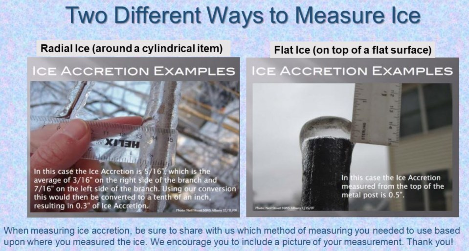
Yup for sure. I mean I guess it could always bump up but a quick thump probably doesn't get it done. Also the NWS is now forecasting straight "flat ice" accretion. No more radial. So 0.5" of flat ice accretion is the new warning threshold but you won't start seeing major impacts until at least 0.75" and probably more like 1.0" Radial ice = flat ice * 0.4
-
We're sort of QPF limited for a big ice storm here. 0.5"-1.0" of all ZR will cause some issues but definitely short of what you need for the ice storm that Kevin dreams about.
-
Low 50s for Groton!
-
Super cold airmass too.