CT Rain
-
Posts
26,272 -
Joined
-
Last visited
Content Type
Profiles
Blogs
Forums
American Weather
Media Demo
Store
Gallery
Everything posted by CT Rain
-
I'm pretty sure they have a lot of crews staging since they are required by law to do it once they declare the level 4.
-
I'm pretty sure after Isaias they're being as proactive as possible.
-
Yeah - I remember a few events like this with pack and a ripping LLJ. This pack is going to be nuked pretty quickly.
-
3km NAM has some epic upslope precip for the Poconos and Catskills. Have to worry about some flash flooding there especially with snow melt.
-
I was actually just thinking about that storm a few minutes ago. The strongest pressure gradient was pretty localized in that storm so it was really SW CT, Long Island, and NYC metro that got hit hard.
-
I wonder if there's sort of a sweet spot just inland away from the cooler waters where the snow pack gets nuked. Maybe HFD/PVD/TAN?
-
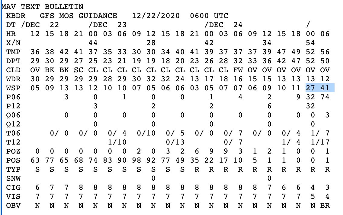
Don't often see >40 knots of MOS around here.
-
Would probably get a name in 2020!
-
There was quite a bit of damage in Guilford from that storm. One of the bigger events I recall growing up.
-
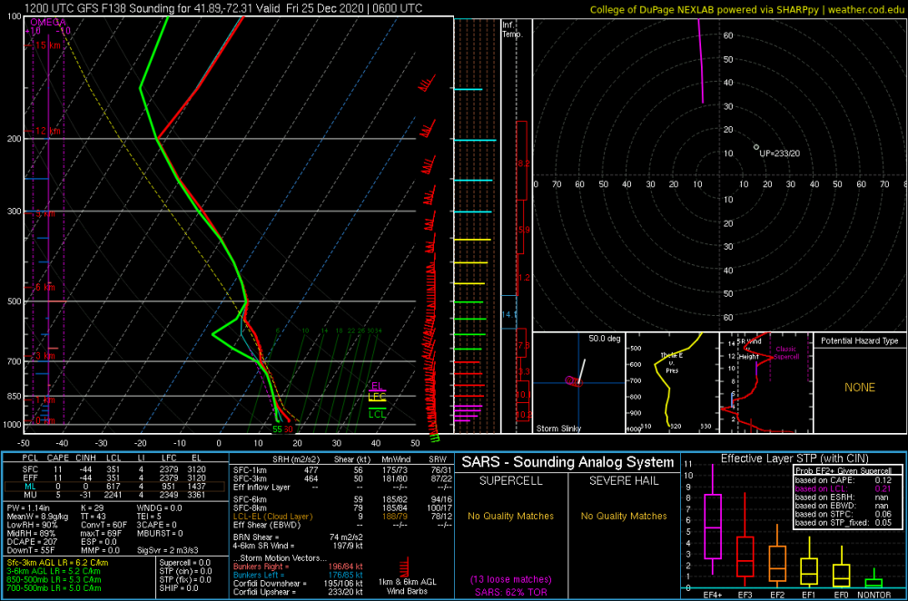
GFS is quite a look that's for sure.
-
I mean who won't want to wake up to text messages from Kevin. "Roaring here. Easily gusting over 60."
- 993 replies
-
- 10
-

-

-
Wild stuff
-
This is a good thread! 1) October 2011 Snowstorm 2) February 2013 Blizzard 3) June 1, 2011 Tornado (was there shortly after in Monson, MA) 4) Tropical Storm Irene 2011 5) Blizzard of '96
-
Vaporized to CYUL? Mid 50s dews and gusting winds will be curtains for the pack south of the Pike.
-
I mean it has 60 knots for MMK and 61 knots to GON. That's not that unimpressive.
-
It's the GFS... so all caveats apply... but this sounding for HFD caught my interest.
-
Yeah most snow is a disaster with the 4" gauge so I always keep it inside... unless it's a quick transition to sleet/rain. I can vouch that getting a spouse to keep an eye on a rain gauge... or better yet clear a snow board and do a core.... is not something that will ever happen.
-
If we still have snow pack take the extreme under.
-
Do you leave the gauge out for snow? I always take it in and just do cores with the snow board.
-
Yeah I agree. They were putting up some huge ASOS precip numbers. They had 2.80" total liquid so a 14:1 ratio. Not like the fluff bomb in NH. KBGM 162353Z AUTO 09009KT 1/2SM SN FZFG VV007 M07/M09 A3004 RMK AO2 TWR VIS 3/4 SLP199 P0011 60028 T10721089 11056 21083 58023 RVRNO KBGM 170553Z AUTO 1/4SM +SN FZFG VV002 M09/M11 A2985 RMK AO2 TWR VIS 3/4 SLP136 P0040 60120 T10891106 11072 21089 58023 RVRNO KBGM 171153Z AUTO 02011KT 3/4SM BR VV013 M09/M11 A2990 RMK AO2 SFC VIS 1 SNEMM SLP153 P0007 60131 70279 T10891106 11089 21094 51008 PWINO FZRANO RVRNO $
-
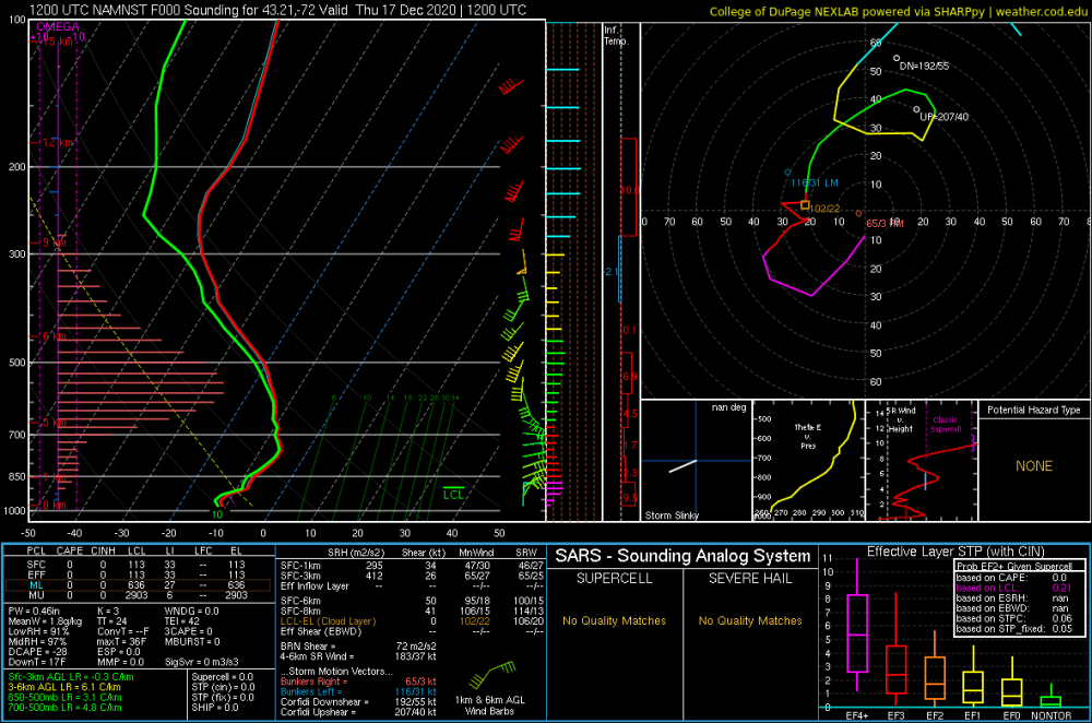
I mean it's possible the DGZ wasn't deep but there was sufficient lift there for it to puke dendrites. Obviously a deeper DGZ will help but it's not necessary. Also looks conditionally unstable above the DGZ in both which is definitely good.
-
For sure. Pretty unusual to see that strong of a veering wind profile (WAA) that high up. Really maximized that omega plus the conditionally unstable layer above as you mentioned.
-
Here's a NAM sounding over Brian's fanny from this morning. Don't get a better DGZ signal than this.
-
They look like gravity waves to me.
-
A bit around 3 a.m. Most was just ugly snowflakes.