CT Rain
-
Posts
26,302 -
Joined
-
Last visited
Content Type
Profiles
Blogs
Forums
American Weather
Media Demo
Store
Gallery
Everything posted by CT Rain
-

Significant Severe Weather Event Possible Thursday, August 27, 2020
CT Rain replied to weatherwiz's topic in New England
Here's our coverage as the storms moved into the New Haven area. Pretty impressive live shots from Hamden and New Haven in there too. https://www.youtube.com/watch?v=Yow0-a_YDe0 -
Significant Severe Weather Event Possible Thursday, August 27, 2020
CT Rain replied to weatherwiz's topic in New England
Yeah, looks like straight line wind damage to me. Radar matched what I saw on the ground very well... narrow path that reached max strength over North Haven followed by the circulation occluding and a hellacious RFD surge southeast of there. I don't really like the NWS classification of microbursts... this was just a really wide swath of RFD damage. -
Significant Severe Weather Event Possible Thursday, August 27, 2020
CT Rain replied to weatherwiz's topic in New England
I wrote about the storm in my blog if anyone's interested. https://www.nbcconnecticut.com/weather-news/on-ryans-radar/august-27-tornado-event/2325826/ -
Significant Severe Weather Event Possible Thursday, August 27, 2020
CT Rain replied to weatherwiz's topic in New England
Looks like it was a meteotsunami in Long Island Sound. -
Significant Severe Weather Event Possible Thursday, August 27, 2020
CT Rain replied to weatherwiz's topic in New England
We mentioned Leete's Island and Stony Creek a few times on air this afternoon - was a wild looking storm down that way. -
Significant Severe Weather Event Possible Thursday, August 27, 2020
CT Rain replied to weatherwiz's topic in New England
Well that was quite a day -
Significant Severe Weather Event Possible Thursday, August 27, 2020
CT Rain replied to weatherwiz's topic in New England
Seems like the convection between ALB and BGM is going to help at least temporarily keep the warm front south as it moves toward CT. -
Significant Severe Weather Event Possible Thursday, August 27, 2020
CT Rain replied to weatherwiz's topic in New England
Yeah, that's not great. -
Significant Severe Weather Event Possible Thursday, August 27, 2020
CT Rain replied to weatherwiz's topic in New England
Meanwhile, here in reality, Chris's point is very good. Doesn't look like a widespread event but rather a real nasty cluster of storms near and along the warm front. Too far south is capped and too far north is wedged. -
Significant Severe Weather Event Possible Thursday, August 27, 2020
CT Rain replied to weatherwiz's topic in New England
And good effective shear too. -
Significant Severe Weather Event Possible Thursday, August 27, 2020
CT Rain replied to weatherwiz's topic in New England
Drizzle in Tolland? Roofs off in Southington?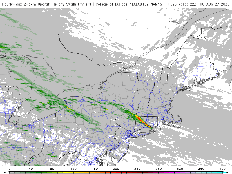
-
Significant Severe Weather Event Possible Thursday, August 27, 2020
CT Rain replied to weatherwiz's topic in New England
There is the potential for some elevated convection NE of the front - watch for some hailers. -
March 12/13/14 Blizzard/Winter Storm/WWA etc
CT Rain replied to Bostonseminole's topic in New England
This could be a rare upslope event into Litchfield Co CT. It's tough to get it without a good synoptic assist. -
March 12/13/14 Blizzard/Winter Storm/WWA etc
CT Rain replied to Bostonseminole's topic in New England
To be honest, we get so many bad snowfall reports in the media (some intentional, some not) it's easy to toss the outliers at first. -
March 12/13/14 Blizzard/Winter Storm/WWA etc
CT Rain replied to Bostonseminole's topic in New England
Isoplethed this as best we could.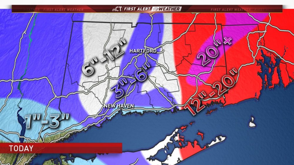
-
March 12/13/14 Blizzard/Winter Storm/WWA etc
CT Rain replied to Bostonseminole's topic in New England
Nice! Where in Scotland? Josh wants to head up there to take some pictures of the jackpot zone. -
March 12/13/14 Blizzard/Winter Storm/WWA etc
CT Rain replied to Bostonseminole's topic in New England
lol you mehd your way to 5" -
March 12/13/14 Blizzard/Winter Storm/WWA etc
CT Rain replied to Bostonseminole's topic in New England
Only 4" on my snow board in WeHa. -
March 12/13/14 Blizzard/Winter Storm/WWA etc
CT Rain replied to Bostonseminole's topic in New England
Yeah woof. That was unpleasant. -
March 12/13/14 Blizzard/Winter Storm/WWA etc
CT Rain replied to Bostonseminole's topic in New England
It's not snowing hard there yet? -
March 12/13/14 Blizzard/Winter Storm/WWA etc
CT Rain replied to Bostonseminole's topic in New England
Mid level magic IMBY. We take. -
March 12/13/14 Blizzard/Winter Storm/WWA etc
CT Rain replied to Bostonseminole's topic in New England
Who knows... maybe an HFD crusher??? -
March 12/13/14 Blizzard/Winter Storm/WWA etc
CT Rain replied to Bostonseminole's topic in New England
Hard to figure out where that western band will setup and pivot. It's definitely scooting east pretty good. Does it continue or does it slow and pivot? Snow is picking up here for sure... probably close to moderate. -
March 12/13/14 Blizzard/Winter Storm/WWA etc
CT Rain replied to Bostonseminole's topic in New England
Only about 1.5" here so far. We were stuck in that subsidence zone earlier. Blah. -
This thread is a total triple bunner.