

CT Rain
-
Posts
26,272 -
Joined
-
Last visited
Content Type
Profiles
Blogs
Forums
American Weather
Media Demo
Store
Gallery
Everything posted by CT Rain
-

Significant Severe Weather Event Possible Thursday, August 27, 2020
CT Rain replied to weatherwiz's topic in New England
Oh wow - figured it was bad. You can track the RFD surge from the Farm River in North Branford/Foxon right over Snake Hill and then down toward Tisko off Damascus Rd. Did you ever get your drone up? -
It was a fun one here. Some of the best winds I've seen for about an hour.
-
Significant Severe Weather Event Possible Thursday, August 27, 2020
CT Rain replied to weatherwiz's topic in New England
Yeah I imagine Snake Hill is an absolute mess. I'm also wondering how it is over by the Supply Ponds... the core of the strongest wind went from Snake Hill right over the Supply Ponds and then down through Damascus Rd near Tisko. Let me know what you see - I'd love to take a look! -
Significant Severe Weather Event Possible Thursday, August 27, 2020
CT Rain replied to weatherwiz's topic in New England
I was out on the Sound Sunday and saw the damage from the water. The most impressive damage was just west of you over the Thimbles where there were a number of snapped flag poles, snapped/uprooted trees, etc. Lots of debris in the water including flipped over docks, limbs, etc. What a mess. Glad you're OK. -
Significant Severe Weather Event Possible Thursday, August 27, 2020
CT Rain replied to weatherwiz's topic in New England
I drove around Branford yesterday and the damage is remarkable. Widespread 80-100 mph gusts with snapped stands of hardwood trees, some structural damage, etc. Have to imagine it's the worst damage in town since at least Hurricane Gloria. What struck me overall was the pretty much continuous damage path from Bethany to Hamden to North Haven and then North Branford/Foxon/Branford. One of the most impressive swaths of widespread damage I can recall outside of a significant tornado in New England. -
Significant Severe Weather Event Possible Thursday, August 27, 2020
CT Rain replied to weatherwiz's topic in New England
It was in time for Branford but definitely late for Bethany and Hamden. -
Significant Severe Weather Event Possible Thursday, August 27, 2020
CT Rain replied to weatherwiz's topic in New England
Here's our coverage as the storms moved into the New Haven area. Pretty impressive live shots from Hamden and New Haven in there too. https://www.youtube.com/watch?v=Yow0-a_YDe0 -
Significant Severe Weather Event Possible Thursday, August 27, 2020
CT Rain replied to weatherwiz's topic in New England
Yeah, looks like straight line wind damage to me. Radar matched what I saw on the ground very well... narrow path that reached max strength over North Haven followed by the circulation occluding and a hellacious RFD surge southeast of there. I don't really like the NWS classification of microbursts... this was just a really wide swath of RFD damage. -
Significant Severe Weather Event Possible Thursday, August 27, 2020
CT Rain replied to weatherwiz's topic in New England
I wrote about the storm in my blog if anyone's interested. https://www.nbcconnecticut.com/weather-news/on-ryans-radar/august-27-tornado-event/2325826/ -
Significant Severe Weather Event Possible Thursday, August 27, 2020
CT Rain replied to weatherwiz's topic in New England
Looks like it was a meteotsunami in Long Island Sound. -
Significant Severe Weather Event Possible Thursday, August 27, 2020
CT Rain replied to weatherwiz's topic in New England
We mentioned Leete's Island and Stony Creek a few times on air this afternoon - was a wild looking storm down that way. -
Significant Severe Weather Event Possible Thursday, August 27, 2020
CT Rain replied to weatherwiz's topic in New England
Well that was quite a day -
Significant Severe Weather Event Possible Thursday, August 27, 2020
CT Rain replied to weatherwiz's topic in New England
Seems like the convection between ALB and BGM is going to help at least temporarily keep the warm front south as it moves toward CT. -
Significant Severe Weather Event Possible Thursday, August 27, 2020
CT Rain replied to weatherwiz's topic in New England
Yeah, that's not great. -
Significant Severe Weather Event Possible Thursday, August 27, 2020
CT Rain replied to weatherwiz's topic in New England
Meanwhile, here in reality, Chris's point is very good. Doesn't look like a widespread event but rather a real nasty cluster of storms near and along the warm front. Too far south is capped and too far north is wedged. -
Significant Severe Weather Event Possible Thursday, August 27, 2020
CT Rain replied to weatherwiz's topic in New England
And good effective shear too. -
Significant Severe Weather Event Possible Thursday, August 27, 2020
CT Rain replied to weatherwiz's topic in New England
Drizzle in Tolland? Roofs off in Southington?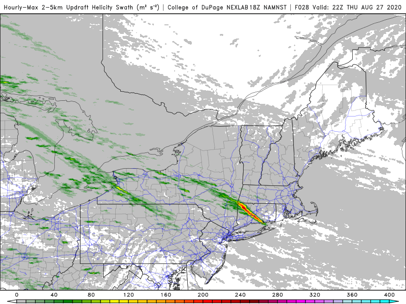
-
Significant Severe Weather Event Possible Thursday, August 27, 2020
CT Rain replied to weatherwiz's topic in New England
There is the potential for some elevated convection NE of the front - watch for some hailers. -
It also has to strengthen some. A 1002 mb low over BDR isn't going to be very exciting. If the UKMet is right with something in the mid 980s then we'll have more of an opportunity for fun.
-
lol no kidding. If this goes too far west I'd be worried about missing out on rain. Do think there's a risk for some tornadoes east of the storm's path and at least some gusty wind particularly south coast. Not a huge storm but may be fun for some.
-
March 12/13/14 Blizzard/Winter Storm/WWA etc
CT Rain replied to Bostonseminole's topic in New England
This could be a rare upslope event into Litchfield Co CT. It's tough to get it without a good synoptic assist. -
March 12/13/14 Blizzard/Winter Storm/WWA etc
CT Rain replied to Bostonseminole's topic in New England
To be honest, we get so many bad snowfall reports in the media (some intentional, some not) it's easy to toss the outliers at first. -
March 12/13/14 Blizzard/Winter Storm/WWA etc
CT Rain replied to Bostonseminole's topic in New England
Isoplethed this as best we could.
-
March 12/13/14 Blizzard/Winter Storm/WWA etc
CT Rain replied to Bostonseminole's topic in New England
Nice! Where in Scotland? Josh wants to head up there to take some pictures of the jackpot zone. -
March 12/13/14 Blizzard/Winter Storm/WWA etc
CT Rain replied to Bostonseminole's topic in New England
lol you mehd your way to 5"


