CT Rain
-
Posts
26,302 -
Joined
-
Last visited
Content Type
Profiles
Blogs
Forums
American Weather
Media Demo
Store
Gallery
Everything posted by CT Rain
-
Meh that storm sucked
-
We've seen convection screw up thermal profiles due to latent heat release but this was pretty rare.
-
Right? Just crazy
-
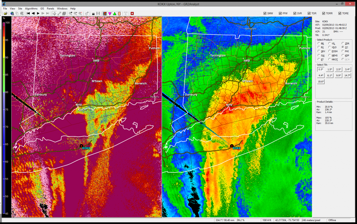
Finally made some animations of the level 2 radar data from OKX from the blizzard. On the left is base reflectivity and the right is correlation coefficient. Notice how when the convection fires along that monster zone of frontogenesis on LI/CT CC drops rapidly indicating mixed phase. CC was very low at times (<0.75) which is pretty unusual for a winter storm. A lot of what you had was large, heavily rimed snowflakes and monster wet aggregates. In some cases we had hail under the strongest convection and in other cases we had sleet which seemingly appeared out of nowhere likely due to latent heat release from the convection screwing up the thermal profiles. Almost saw sleet up to Tolland in this storm! There are some really cool things in the dual pol data including depolarization streaks as the ice crystals were forced to line up by the electric field (lots of charge from lots of graupel interactions), gravity waves over NYC to the west of the strong convection (not sure if this was convection related or not) that likely played with the ptype over Nassau County and Queens (you can see lines of low CC even though BR doesn't show the inertial gravity waves too well in this case, and also lots of nonuniform beam filling down radial which screwed with the dual pol products from OKX over RI, N CT, and MA. http://ryanhanrahan.files.wordpress.com/2013/11/brcc_part1.gif
-
I can't take the credit - http://www.nwas.org/jom/abstracts/2013/2013-JOM21/abstract.php Pretty cool though to see that in a snowstorm - would be interesting to compare when the depolarization streaks appeared and archived lightning activity in the area.
-
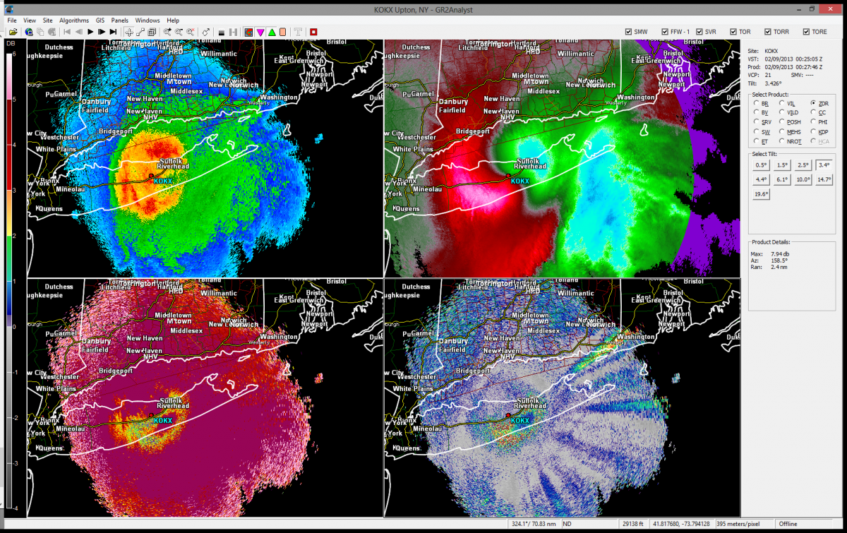
Missed this at the time - but take a look at the dual pol data from the Feb blizzard off OKX. Above the freezing layer (note bright band in CC) the positive/negative streaks of ZDR are depolarization streaks. Atmosphere was so highly electrified the ice crystals were aligning with the electric field vector. Pretty sweet. This is the 3.4 deg tilt so the top of the bright band is ~5kft and the depolarization streaks (normally seen in the anvils of thunderstorms) are above 8kft. The high amount of graupel and small hail in the clouds from convection was able to electrify the clouds enough for this fun.
-
The 00z OKX sounding did have a layer near 0c at 900 mb before the balloon was ripped to shreds. I do agree that in that band with insane reflectivities (50-60 dbz oriented north/south - so definitely not your typical "bright band") you probably had suspended graupel/hail that was able to form. What is a little odd though is the reports of rain in interior SE CT during the height of the banding. Makes me think latent heat release from convection was intense enough to change an all snow sounding to a rain sounding - at least briefly. Essex, Old Lyme, and other towns around there flipped to pouring rain for a period of time. If you get a chance pull up the OKX level 2 data and check it out. It's really cool.
-
I know, it was a once or twice-in-a lifetime kind of event. Less snow in 1978 but the drifts (and wind) made up for it. Hopefully we'll get something like that again. I could almost see the "hail sleet" being a sleet/hail combo where the vertical motion (and convection) was intense enough to produce sneaky warm layers via latent heat release and the vertical motion was suspending sleet pellets and you were getting riming of supercooled water that refroze on the sleet pellet (like hail growth) or in some cases fusing sleet pellets together. The dual pol products from OKX show all sorts of weird stuff going on with mixing/melting layers just popping up all over the place but generally focused in a N/S band from just east of OKX north into Tolland County right along the eastern edge of that superband where convergence in low levels was very strong and some upright convection was taking place. If anyone has any other ideas/theories please join in! I'd like to save a bunch of the dual pol screen grabs and make them into a movie file so you all can see.
-
Yeah that's what I'm thinking. The met here from Clinton was reporting giant sleet (all ice/not soft hail or graupel) that was as big as peas. We had a bunch of reports of that and also reports of rain as far north as Essex. Seems to me the lift was so great in the 0-6kft layer and there was upright convection ongoing you were able to develop small hail (or sleet that was lofted/suspended in an updraft and grew) which is just remarkable. The RAP BUFKIT soundings for GON and HVN at were all subfreezing (by a fairly substantial margin) in the 00z-02z time frame so I'm not sure how else to explain it. As for the rain I think the convection was so vigorous the latent heat release was messing with low level thermal profiles and developing pockets of >32F air where you wouldn't normally expect to see them. If anyone as a chance to look at the dual pol data from that storm it is absolutely fascinating. I have it all on GR but I don't think I'm able to save a loop of it.
-
wtf was going on over S CT. That was the fun monster aggregate/sleet/small hail combination in the convection. I love how it's snowing south of OKX in the Atlantic ocean and it's all mixed up in S CT from East Lyme to HVN. I'm guessing you had some latent heat release screwing around with ptype in low levels and also probably had enough upright convection to result in some hail development.
-
Just looked through the Feb blizzard thread and downloaded all the level 2 radar data from the peak of the event. Insane. What a storm.
-
Most fun storm ever. A little depressing that I may never see a storm like it again. http://www.youtube.com/watch?v=tYY97QZadHI
-
Did you invite Ginx over to take photos of PDII?
-
That morning I thought it would be a struggle to start as snow in the valleys and a struggly to start accumulating in the hills. Also I wasn't relying on the mega deformation band to just crush north central and northwest Connecticut near the end of the storm. I had bumped those numbers up from the nigh before... and then around noon or 1pm I bumped them up again.
-
I actually haven't saved some of the damage stuff yet but I'll try to do that tonight actually. By Monday and Tuesday we have some pretty good damage video. I actually have 5 front pages of the Hartford Courant framed for the week following the storm for my weather lair.
-
Thanks will. It does pain me sometimes to forecast snow for tolland. I get a sick satisfaction with disappointing him on air
-
Here's more octosno porn
-
Yeah it was nuts. Definitely my most memorable snowstorm for the exceptional damage, 10 days without power, and the pure awesomeness of the meteorology. It was by far the most anomalous storm I've ever forecasted. I honestly couldn't believe I was saying the kinds of things I was on the air that morning before the snow started falling.
-
Yup I was in Holden a couple days after... and shortly after the storm I was up in the high terrain up on the east slope of the Berks. You are correct that the extent of the damage wasn't terribly widespread. What was remarkable about the snowstorm damage was that the worst damage was in the lower elevations and highly/densely populated areas. Once you got up above 700 or 800 feet the snow was a bit fluffier and you had less leaves on the trees in general. Imagine ice with leaves lol.
-
Yeah the damage in some parts of the Farmington Valley was just unreal. On par with some of the stuff I saw in Massachusetts after the 2008 ice storm.
-
Yeah there were some areas in CT that saw very little from Oct 2011. So 1978 was more widespread with heavy impact though western CT did not see as much of an impact and southern and eastern parts of the state. The wind was vicious though so you had very impressive drifting even where you had less than 20". The fact so many people were stranded turned the storm into a legendary one for many. Had the storm occurred on a weekend it probably would have had much less of an impact (if it happened 20 years later the number of 4WD/AWD cars would have alleviated some of the issues too). I would probably edge 1978 over 2011 in CT particularly because it was more widespread and impacted everyone. The two are in the same league, however, something that CT hasn't been able to say in over 30 years.
-
Yeah agreed. Looking at specific storms we all have memories of different ones for different reasons. 3/93, 1/96, 4/97, 3/01, 2/03 all have pretty special places in my weather memory. Oct 11 blows them all out of the water though.
-
Yeah agreed. Judging storms by impact I think is the most important means of ranking storms. The 2006 powder bomb was the least impactful 26" of my life. I cleared my car off in about 3 minutes. I would have to give the edge to 1978 and definitely 1888 over 2011. All three storms were quite different.
-
The 3 biggest for impact would have to be October 2011, February 1978, and March 1888. 1888 for amounts, 1978 for drifts/amounts/strandings/coastal flooding, and 2011 for damage. I'm not sure any others come into that category.
-
Trying to put October 2011 in some type of historical perspective in CT. I can't think of any snowstorm other than 1978 that had the same type of societal impact in post-1900. Can anyone think of any others?