-
Posts
26,257 -
Joined
-
Last visited
Content Type
Profiles
Blogs
Forums
American Weather
Media Demo
Store
Gallery
Everything posted by CT Rain
-
lol
-
It's all good. I'm pretty spoiled and travel a ton to cool places. I'll be back. I've always said that a hurricane is the only weather that will cut a trip short for me. Blizzards are a dime a dozen around here and tornadoes who knows until it's happening.
-
That's actually not true. All the stations had continuous coverage that day. One of the reasons why stations will do this for tropical systems and snowstorms is that people will watch in large numbers (our ratings will be much higher for storm coverage than for what the typical programming is) and most people only watch for small chunks of time - so if you're on for 10 hours straight you provide a service for someone who may be interested in checking in every now and then.
-
Hurricane hunter obs are not impressive.
-
The GFS would be massive hydro problems in CT and W Mass.
-
It is. I mean I would say anything that’s a top 5 outage in the last 50 years is historic and isaias was #3 on that list was a 50 mph TS.
-
Yeah I mean rain soaked soil, potential for 60 gusts and our infrastructure does not look great.
-
I’m somewhere between France and Newfoundland right now
-
I mean it doesn’t take much to knock out power here. Isaias was a top 3 outage for Eversource.
-
This seems like the biggest wildcard to me at this point. Track is relatively locked in but I can see a pretty wide range in impacts right now with uncertainty wrt strength.
-
No doubt about that. I was in town for about 10 days leading up to the 4th and it was absolutely mobbed. Hard to think of a better way for a virus to spread than packed bars, little ventilation, terrible weather, etc.
-
I do think the interesting thing with the new CDC guidance and Delta overall is how the public has really just moved on. I live in one of the most liberal towns in one of the most liberal states (not Cambridge, but close) and yesterday at the gym I saw zero people in masks out of maybe 60 or 70 people there. We're in that fuzzy space between containment/mitigation and people just making judgment calls based on their own risk tolerance. For example I was traveling quite a bit and got a rapid test a few hours before going to a wedding just to be sure... but I'm not changing my day to day behavior after being vaxxed and not living with anyone who's high risk.
-
Yeah - seems like we're probably farther into Delta than we think and this will run its course sooner rather than later.
-
Also wrt to the Ptown cluster... I was there for about 10 days leading up to July 4th and town was an absolute mob scene. It's always packed in the summer but this was unbelievable. With terrible weather and bars/clubs so packed you couldn't move (with virtually no ventilation, low ceilings, etc) it seems like a perfect environment for a few superspreader events. Even worse than a cruise ship. Not a huge surprise a number of vaccinated people were infected... but there were tens of thousands who weren't.
-
Is it that crazy? I know about 20 people who had covid in Ptown and they were either asymptomatic or very mildly symptomatic. They never would have been tested had the news of the "provincetown cluster" been everywhere. Seems reasonable that as the spread is more significant in younger people who are mildly or asymptomatic there is going to be a big drop in testing and tons and tons of cases going unreported.
-
My sense is that it all winds up south with the MCS coming out of the Great Lakes tonight. But given the time of year (warm SSTs) will have to watch that screaming LLJ.
-
Sorry for your loss, Jay.
-
I mean at least what I've read everywhere was that it was unclear whether this variant was more dangerous/deadly... though it was clear it was much more transmissible. Even if it is as virulent as prior variants (for arguments sake) even places with low vax rates... those who are vaccinated skew toward those who are high risk and elderly. So just that alone would bring down bad outcomes significantly.
-
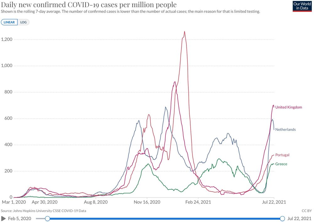
Delta also won't last forever. places with low vax rates in the south will have an ugly August with it but elsewhere there is a lot of protection from severe disease thanks to prior infection and vaccination. In Europe we're already starting to see things turnaround as Delta peaks with far lower hospitalization rates/deaths than previous spikes. India's spike was vicious (and deadly) but it was also quite quick.
-
Yeah I think it depends on where. In Provincetown, MA which is probably one of the most liberal towns in America it's certainly not an issue. I do think international travel is going to have vax requirements for quite some time though.
-
There's one large venue in Provincetown that was strict about enforcing vax status and it was fine. No one cared and the line just took a while longer. And of course vaccinated people can still have and transmit the disease but the odds are lower than if you're someone who's unvaccinated. So yeah, you can still have an outbreak but it's just not as likely. It doesn't bother me if a restaurant or venue wants to enforce that. International travel is doing it too - at least to get into the Schengen Zone.
-
Choosing not to get vaccinated is a personal decision - but I have no problem not letting the unvaxxed into a packed nightclub or concert. I got a couple tests after going to Ptown to make sure I wouldn't transmit the virus to others. Thankfully negative. Going to test again before a wedding this weekend just to be double sure.
-
I know a ton of people who contracted COVID in Provincetown over July 4th weekend and all of them were vaccinated and wound up either asymptomatic or mildly symptomatic with no worse than an annoying cold. It's time to move on now that we've decoupled the deaths/hospitalization curve from the case curve. Hard to institute lockdowns or strict mandates for the purpose of protecting those who chose not to get vaccinated.
-
Yeah I actually went back and looked at it just now and I think those are spurious outbounds. The damage is about 2 miles north of where that "couplet" was too.
-
I think there was some side lobe contamination there. The data looked a bit noisy.


